Pennsylvania County U.S. Geological Survey Maps

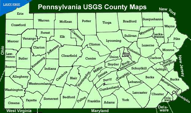
Click on a county to get an index map of that county which will link to USGS maps of the townships. A complete list of Pennsylvania counties (and county seat) is shown below. Active links to neighboring states are also shown.

Pennsylvania USGS County Maps

Adams Co. Map Allegheny Co. Map Armstrong Co. Map Beaver Co. Map Bedford Co. Map Berks Co. Map Blair Co. Map Bradford Co. Map Bucks Co. Map Butler Co. Map Cambria Co. Map Cameron Co. Map Carbon Co. Map Centre Co. Map Chester Co. Map Clarion Co. Map Clinton Co. Map Crawford Co. Map Clearfield Co. Map Columbia Co. Map Cumberland Co. Map Dauphin Co. Map Delaware Co. Map Elk Co. Map Erie Co. Map Fayette Co. Map Forest Co. Map Franklin Co. Map Fulton Co. Map Greene Co. Map Huntingdon Co. Map Indiana Co. Map Jefferson Co. Map Juniata Co. Map Lackawanna Co. Map Lancaster Co. Map Lawrence Co. Map Lebanon Co. Map Lehigh Co. Map Luzerne Co. Map Lycoming Co. Map McKean Co. Map Mercer Co. Map Mifflin Co. Map Monroe Co. Map Montgomery Co. Map Montour Co. Map Northampton Co. Map Northumberland Co. Map Perry Co. Map Philadelphia Co. Map Pike Co. Map Potter Co. Map Schuylkill Co. Map Somerset Co. Map Snyder Co. Map Sullivan Co. Map Susquehanna Co. Map Tioga Co. Map Union Co. Map Venango Co. Map Warren Co. Map Washington Co. Map Wayne Co. Map Westmoreland Co. Map Wyoming Co. Map York Co. Map New York Ohio West Virginia Maryland Delaware New Jersey

Sixty-seven Counties and County Seats

Adams County (Gettysburg)
Allegheny County (Pittsburgh)
Armstrong County (Kittanning)
Beaver County (Beaver)
Bedford County (Bedford)
Berks County (Reading)
Blair County (Hollidaysburg)
Bradford County (Towanda)
Bucks County (Doylestown)
Butler County (Butler)
Cambria County (Ebensburg)
Cameron County (Emporium)
Carbon County (Jim Thorpe)
Clarion County (Clarion)
Centre County (Bellefonte)
Chester County (West Chester)
Clinton County (Lock Haven)
Clearfield County (Clearfield)
Columbia County (Bloomsburg)
Crawford County (Meadville)
Cumberland County (Carlisle)
Dauphin County (Harrisburg)
Delaware County (Media)
Elk County (Ridgway)
Erie County (Erie)
Fayette County (Uniontown)
Forest County (Tionesta)
Franklin County (Chambersburg)
Fulton County (McConnellsburg)
Greene County (Waynesburg)
Huntingdon County (Huntingdon)
Indiana County (Indiana)
Jefferson County (Brookville)
Juniata County (Mifflintown)
Lackawanna County (Scranton)
Lancaster County (Lancaster)
Lawrence County (New Castle)
Lebanon County (Lebanon)
Lehigh County (Allentown)
Luzerne County (Wilkes-Barre)
Lycoming County (Williamsport)
McKean County (Smethport)
Mercer County (Mercer)
Mifflin County (Lewistown)
Monroe County (Stroudsburg)
Montgomery County (Norristown)
Montour County (Danville)
Northampton County (Easton)
Northumberland County (Sunbury)
Perry County (New Bloomfield)
Philadelphia County (Philadelphia)
Pike County (Milford)
Potter County (Coudersport)
Schuylkill County (Pottsville)
Snyder County (Middleburg)
Somerset County (Somerset)
Sullivan County (Laporte)
Susquehanna County (Montrose)
Tioga County (Wellsboro)
Union County (Lewisburg)
Venango County (Franklin)
Warren County (Warren)
Washington County (Washington)
Wayne County (Honesdale)
Westmoreland County (Greensburg)
Wyoming County (Tunkhannock)
York County (York)

Neighboring States

Delaware USGenWeb Map
Ohio USGenWeb
West Virginia USGenWeb
Maryland USGenWeb Map
New Jersey USGenWeb
New York USGenWeb Map

Other Geographic Information

Pennsylvania 1836 (401KB)
Eastern Pennsylvania 1876 (562KB)
Western Pennsylvania 1876 (525KB)
BIG MAP of Western Pennsylvania (446KB)
How To Order USGS Maps
Search GNIS for Geographic Features
List of Pennsylvania Counties (PAGenWeb)
Allegheny/Pittsburgh Plats, Pitt Library
List of Pennsylvania Municipalities & Townships
Pennsylvania Towns and Cities (KeystoneWeb)
Geographic Name Thesaurus
PA Township Search

Back to Pennsylvania County Maps   |   Go to Pennsylvania On-line Histories

blue-green bar

Pennsylvania County Genealogy Sites

blue-green bar


PaGenWeb

Valid HTML 4.01!