
dicksevier@gmail.com

![]()
dicksevier@gmail.com
This page was last updated 4/21/2016
Note that each map may be enlarged by clicking on it or its title. Most can be further enlarged by placing the cursor on the image and then clicking on the button or + in the lower right hand corner.
State Maps
Township Maps
Topographic Maps
Parish Maps
City Maps
Civil War Maps
Website
Statistics
![]()
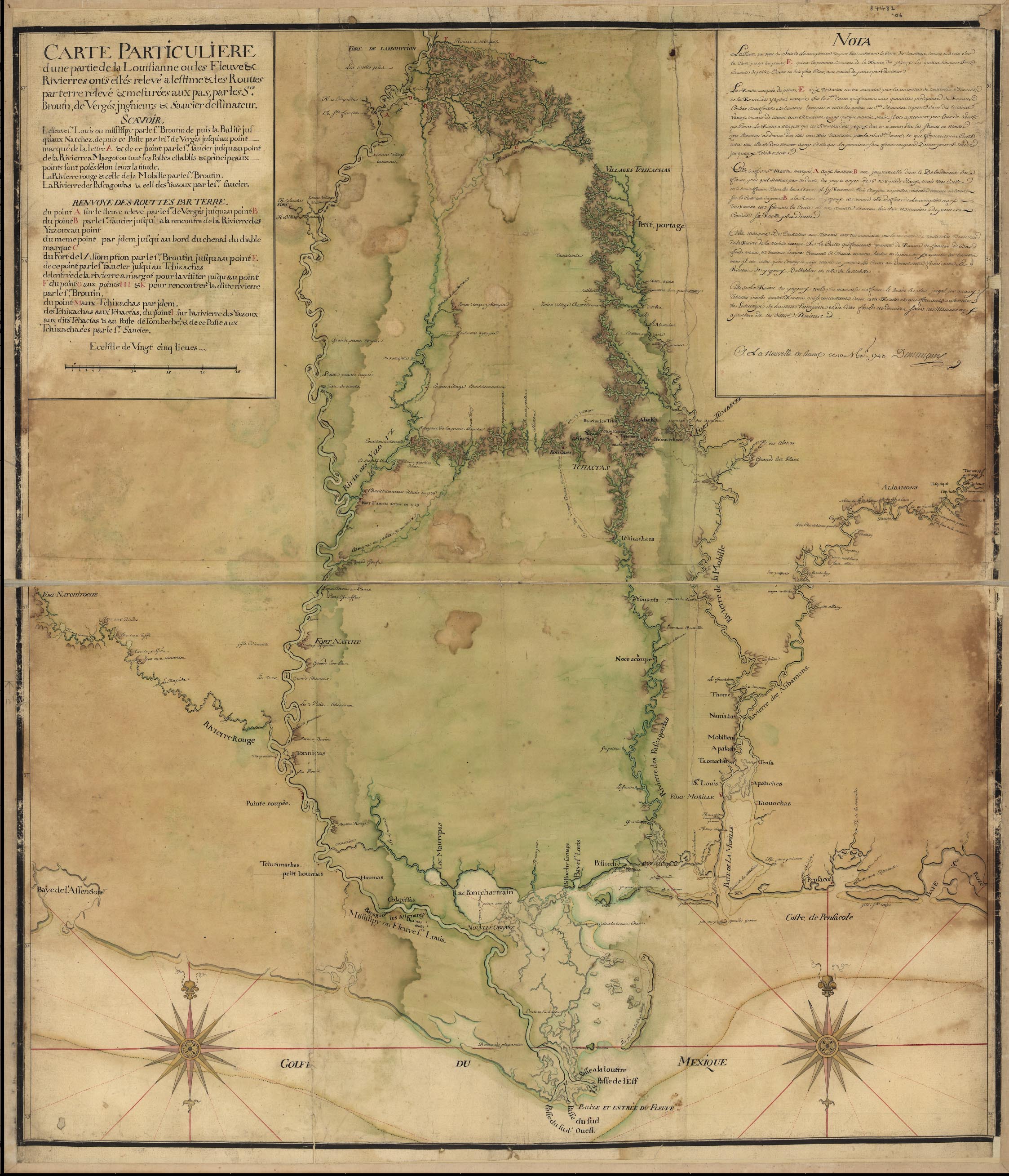 Louisiana 1743 — 884k. This French map of the Mississippi River Valley from Memphis to the Gulf of Mexico and as far east as Mobile includes interior streams, routes, European communities, and Native American settlements, nations, and fortifications. It is based upon the surveys of Broutin, Vergés, and Saucier in Mississippi and Alabama. From Library of Congress
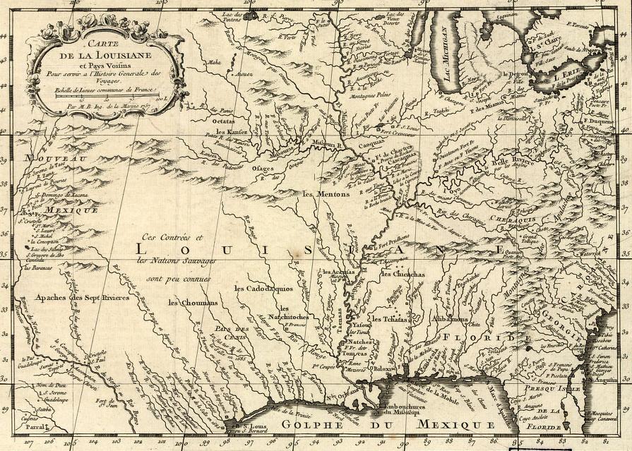 Louisiana 1752 — 211k. Carte de la Louisiane et Pays Voisins. Covers larger area than Louisiana Purchase. From Library of Congress
 Louisiana 1755 — 392k. Part of a larger map, known as the John Mitchell map, covering the approximate east 60% of what is now the United States. The map was made “with the approbations and at the request of the Lords Commissioners for Trade and plantations and is
chiefly composed from ... parts of His Majesty’s Colonies and Plantations in America.” Courtesy of F. Dean Williams
Louisiana 1755 — 392k. Part of a larger map, known as the John Mitchell map, covering the approximate east 60% of what is now the United States. The map was made “with the approbations and at the request of the Lords Commissioners for Trade and plantations and is
chiefly composed from ... parts of His Majesty’s Colonies and Plantations in America.” Courtesy of F. Dean Williams
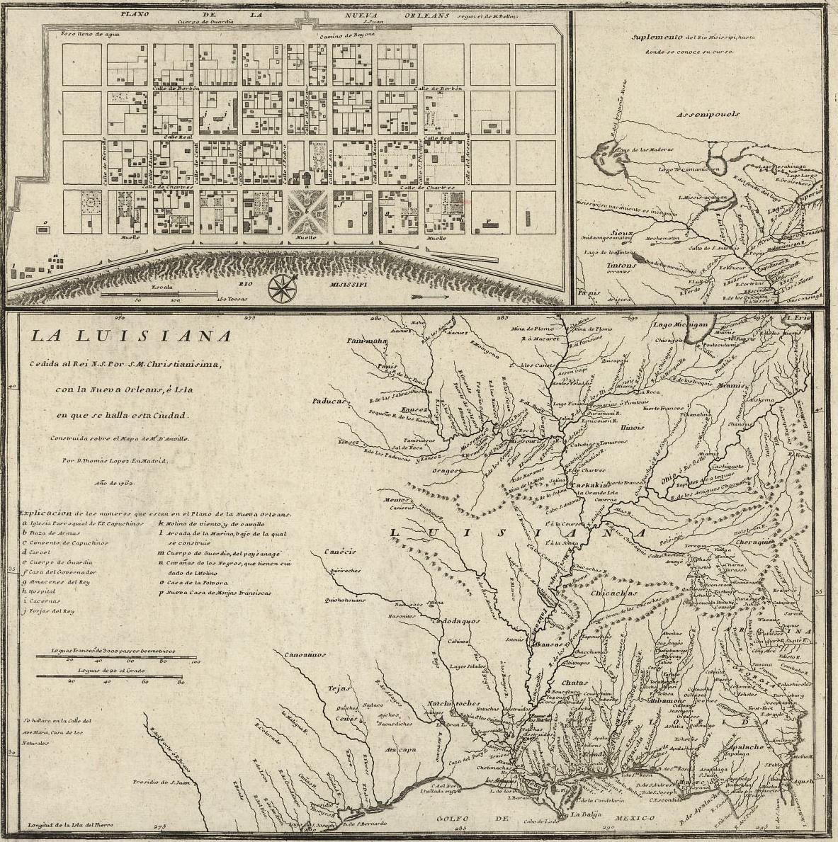 Louisiana 1762 — 395k. Spanish map of what later became the Louisiana Purchase; includes a map of New Orleans - made in Madrid in 1769. From Library of Congress.
 Louisiana 1763 — 144k. Portion of French map of what later became the Louisiana Purchase. From Library of Congress.
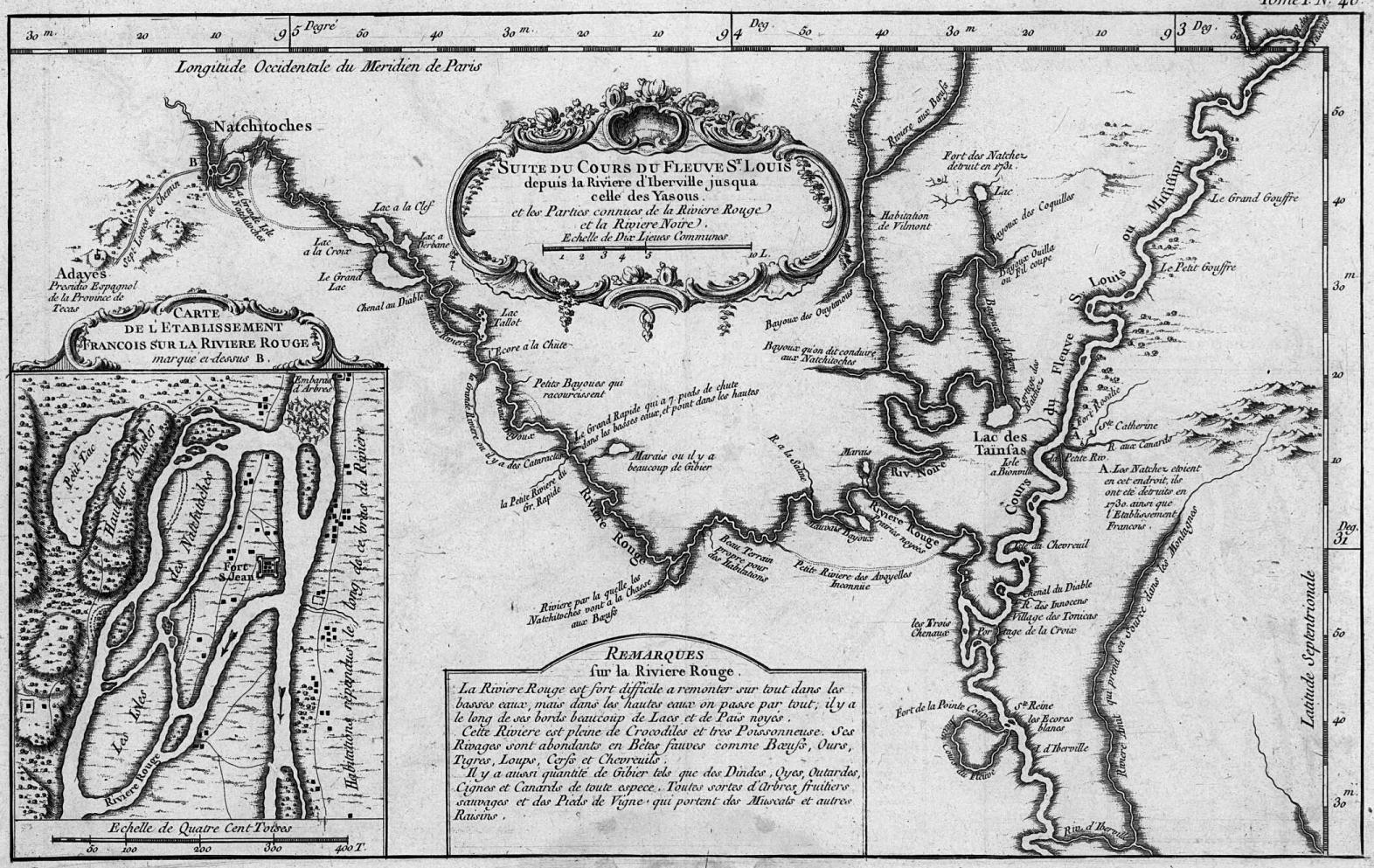 Red River 1764 — 393k. French map of the Red River (Riviere Rouge) from Natchitoches to the Mississippi River. Also shows portions of the Black River (Riviere Noire), Boeuf River (Riviere aux boeufs) and many other rivers and streams in north and central Louisiana. Printed in Paris. From Library of Congress.
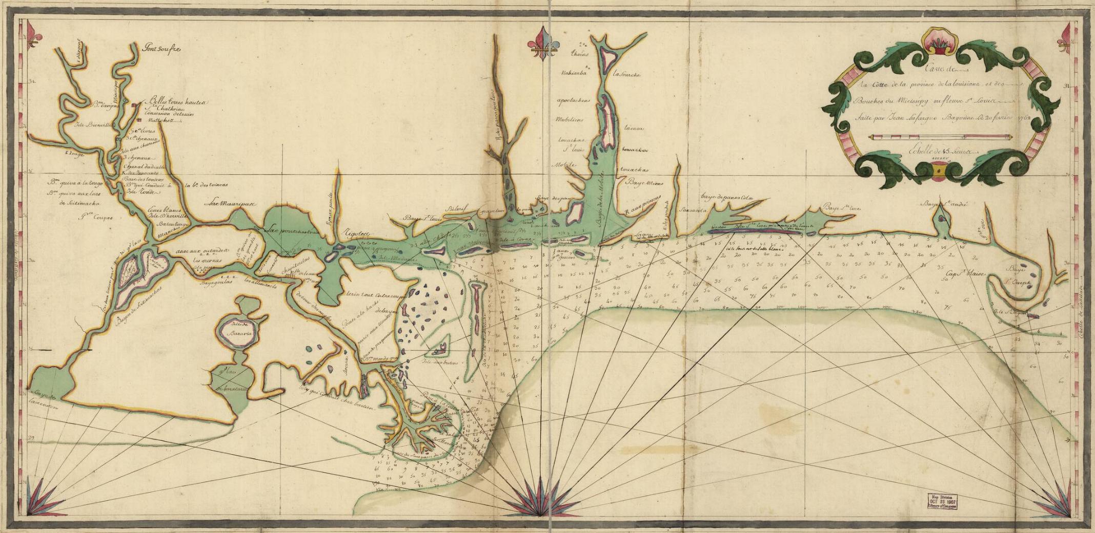 Louisiana-Mississippi Coast 1768 — 338K. In French. Shows mouth of “Micissipy” and related streams. From Library of Congress.
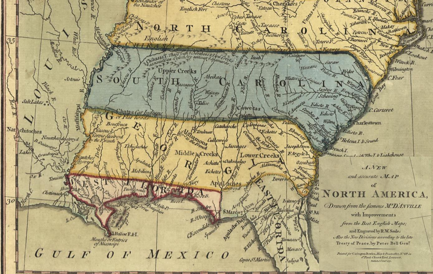 Southern States 1771— 251 k. "A New and Accurate Map of North America, Drawn from the Famous Mr. D'Anville with Improvements From the Best English Maps; And Engraved by R. W. Seale. Printed for Carrington Bowles, London." From Library of Congress.
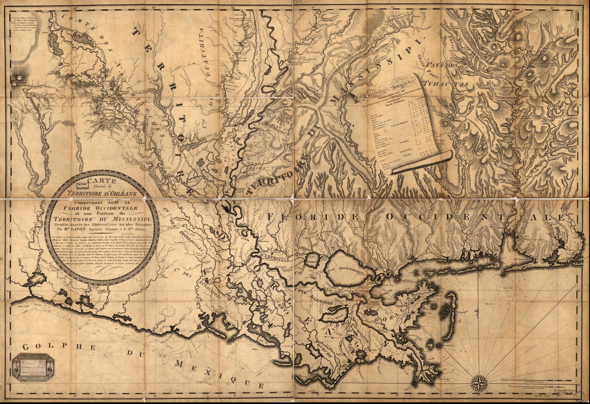 Louisiana 1806 — 992 k. "General chart of the territory of Orleans also including Western Florida and a portion of the territory of the Mississippi according to the most recent observations by Barthélémy Lafon, engineer/geographer in New Orleans." French map made in Paris by Ch. Piquet. From Library of Congress.
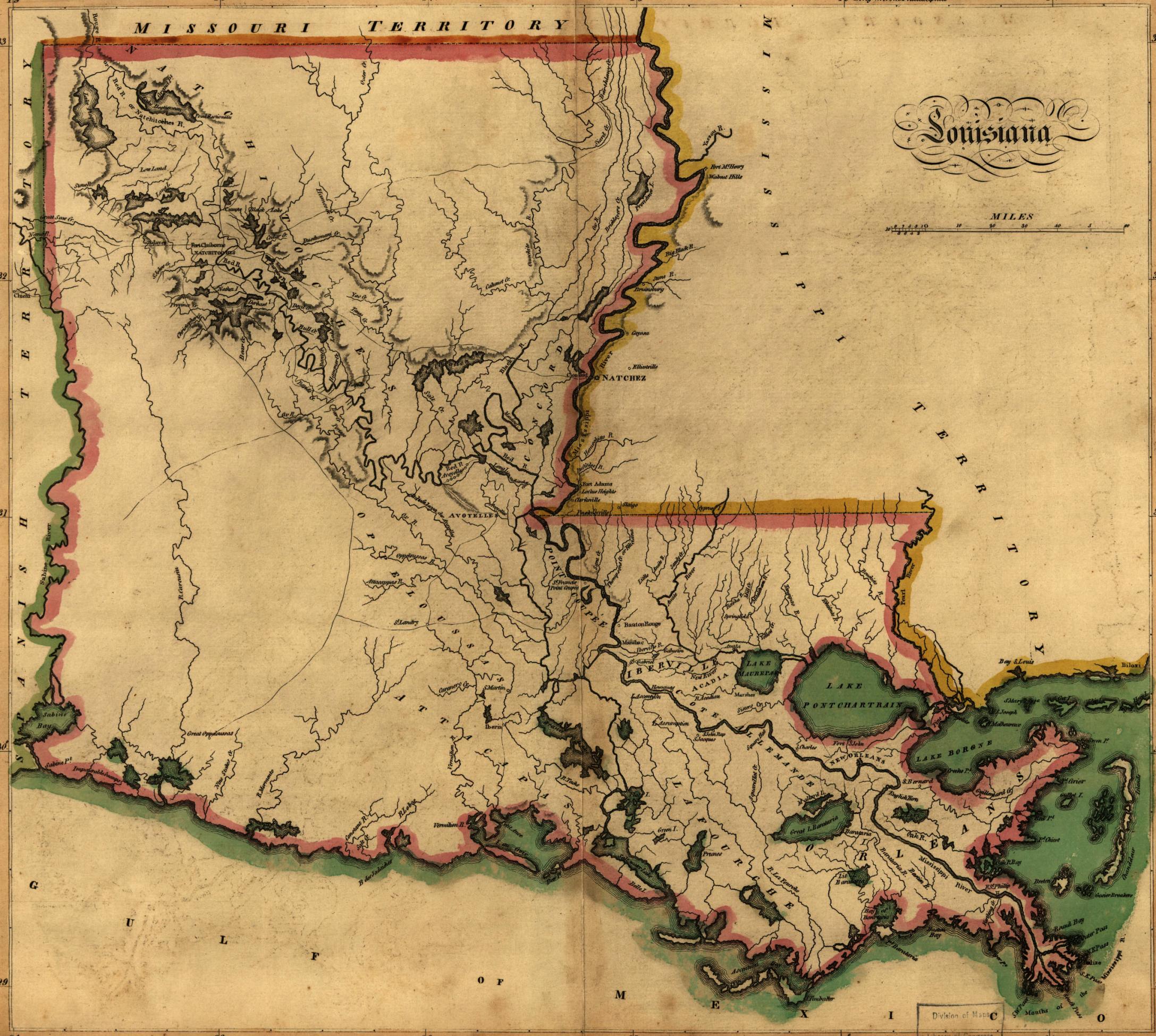 Louisiana 1814 — 746k. From Carey’s General Atlas of the World. Library of Congress.
 Louisiana c1828 — 528k. Shows towns and counties, as they appeared about 1828. Publisher unknown. See Mississippi Index for same map of that state. Courtesy of Charles Brenner, Eudora Welty Library, Jackson, MS.
 Louisiana 1835 — 449k. Map from an 1835 Atlas, published in Boston by Thomas Bradford.
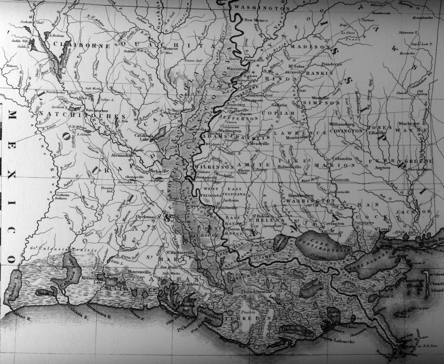
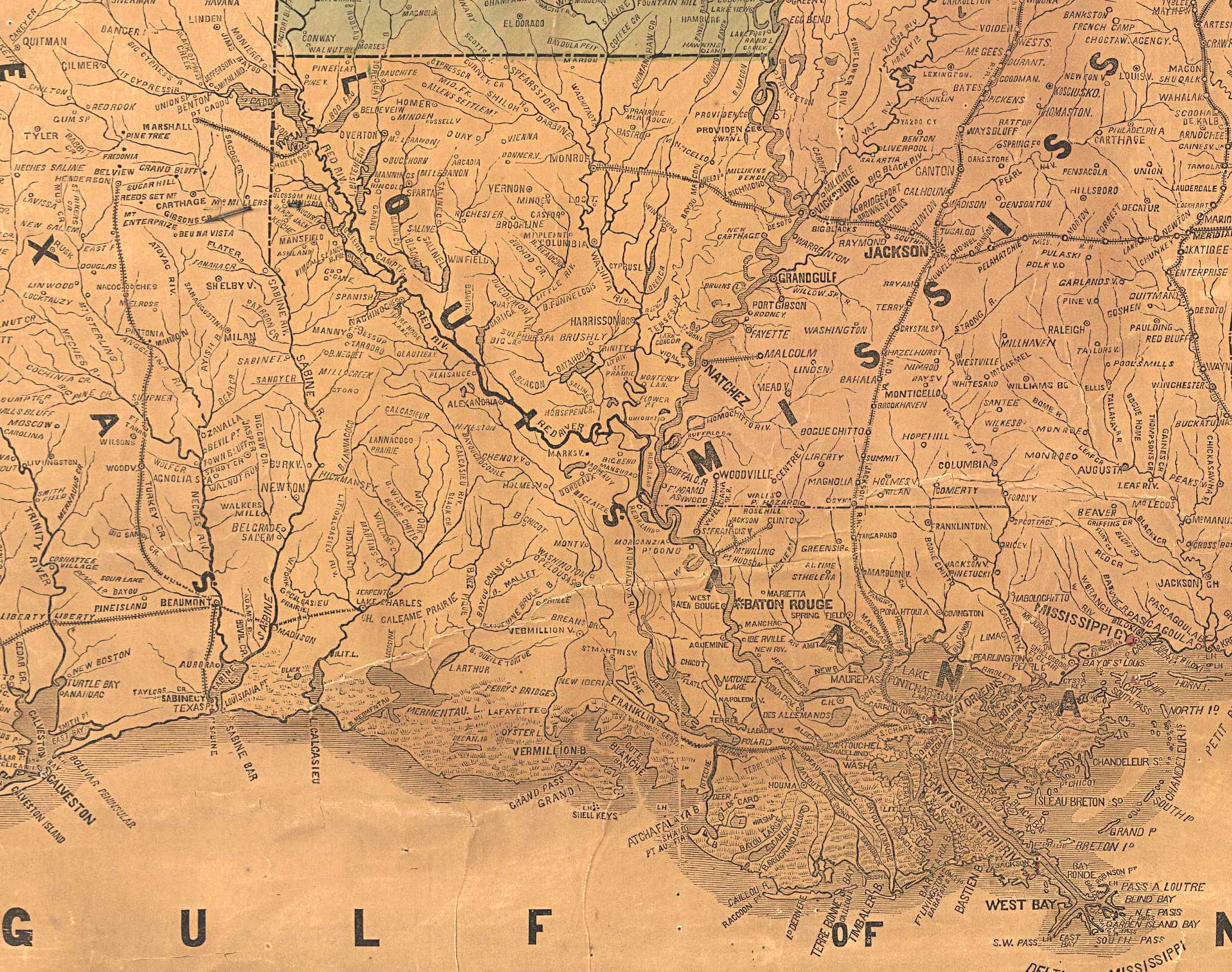
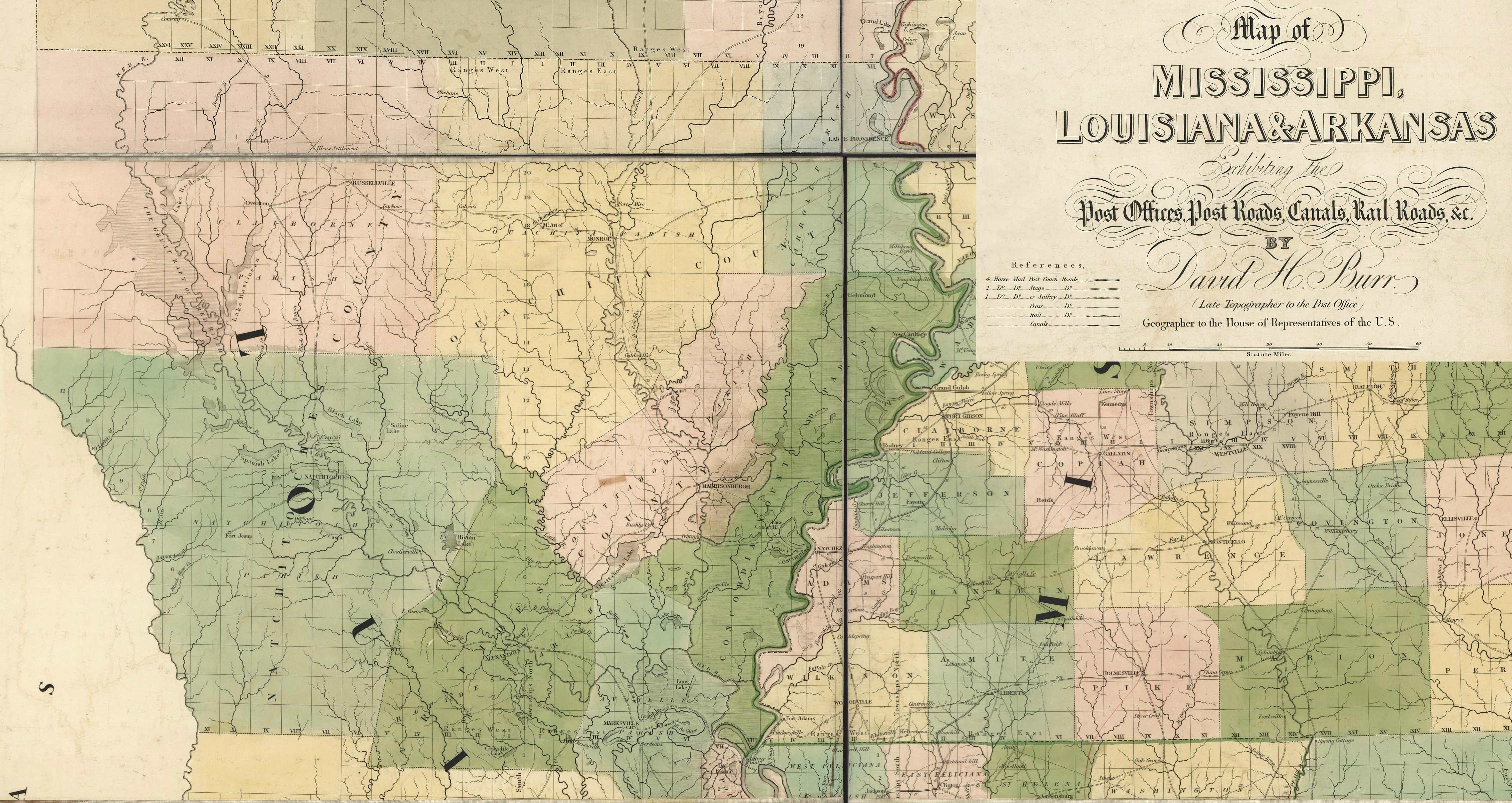 Louisiana 1839 (North) — 1,287k. Very detailed map of Louisiana exhibiting the post offices, post roads, canals, rail roads, &c. by David H. Burr (late topographer to the Post Office), Geographer to the House of Representatives of the U.S. From Burr's The American Atlas (London, J. Arrowsmith, 1839). From Library of Congress.
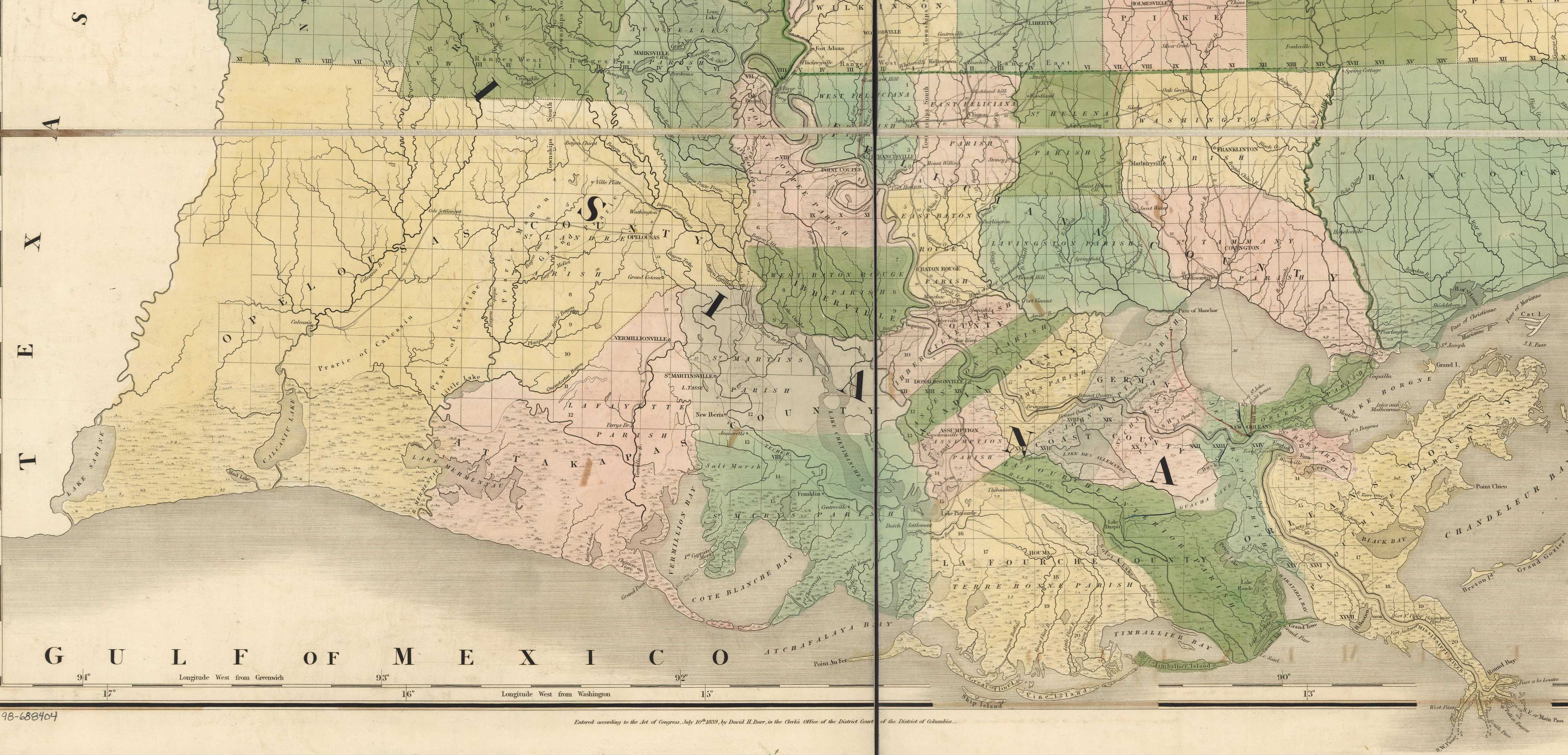 Louisiana 1839 (South) — 1,288k. South half of above map. See North half map for legend.
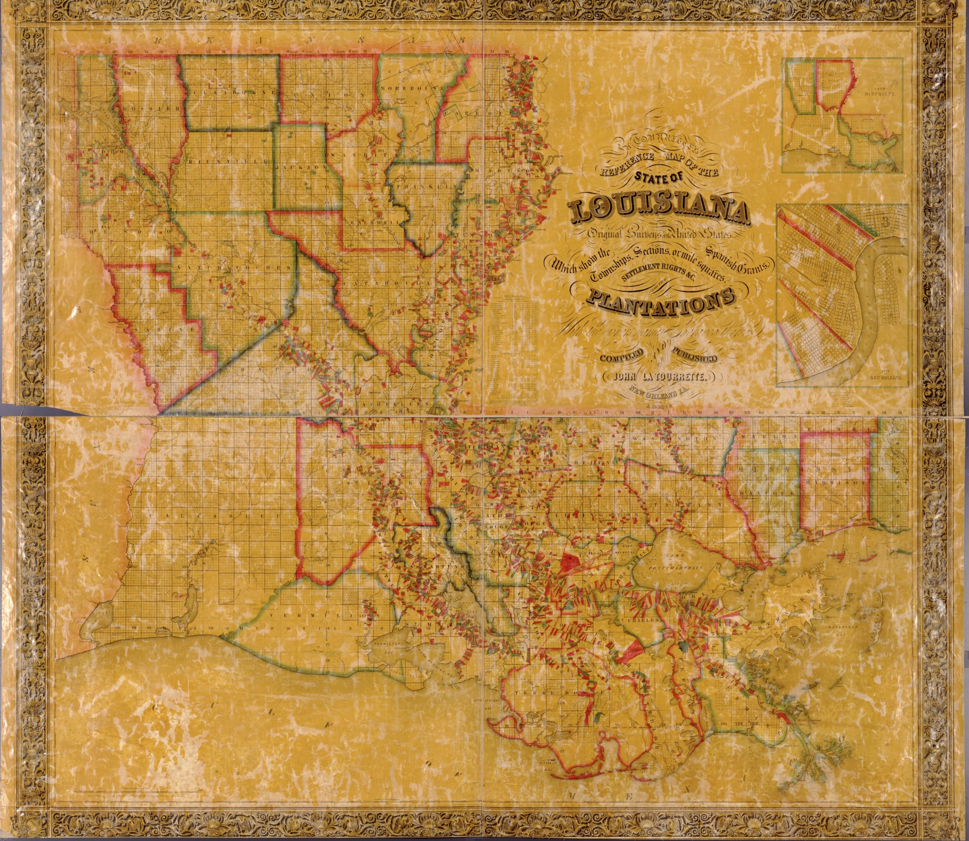 Louisiana 1848 —996k. La Tourrette's 1848 reference map of the state of Louisiana : from the original surveys of the United States, which show the townships, sections, or mile squares, Spanish grants, settlement rights & c., also the plantations with the
owners names engraved thereon / compiled and published by John La Tourrette, New Orleans, LA. ; designed and engraved by Peter J. Grassner, A.D. 1848." From Library of Congress. For examples of maximum resolution see the maps of Madison, Carroll and Tensas parishes.
Louisiana 1848 —996k. La Tourrette's 1848 reference map of the state of Louisiana : from the original surveys of the United States, which show the townships, sections, or mile squares, Spanish grants, settlement rights & c., also the plantations with the
owners names engraved thereon / compiled and published by John La Tourrette, New Orleans, LA. ; designed and engraved by Peter J. Grassner, A.D. 1848." From Library of Congress. For examples of maximum resolution see the maps of Madison, Carroll and Tensas parishes.
 Louisiana 1853 —1,123k. La Tourrette's 1853 reference map of the state of Louisiana : from the original surveys of the United States, which show the townships, sections, or mile squares, Spanish grants, settlement rights & c., also the plantations with the owners names
engraved thereon / compiled and published by John La Tourrette, New Orleans, LA. ; designed and engraved by Peter J. Grassner, A.D. 1853." From Library of Congress. For examples of maximum resolution see the maps of Madison, Carroll and Tensas parishes.
Louisiana 1853 —1,123k. La Tourrette's 1853 reference map of the state of Louisiana : from the original surveys of the United States, which show the townships, sections, or mile squares, Spanish grants, settlement rights & c., also the plantations with the owners names
engraved thereon / compiled and published by John La Tourrette, New Orleans, LA. ; designed and engraved by Peter J. Grassner, A.D. 1853." From Library of Congress. For examples of maximum resolution see the maps of Madison, Carroll and Tensas parishes.
 Louisiana 1853 — 546k. From "Map of the Cairo & Fulton Railroad exhibiting the principal tributary lines as projected and its connections with other railroads west of the Mississippi River, which unite with the Missouri Pacific Railroad, and south projected Pacific Railroad via Elpaso [sic] to the Pacific Ocean, showing also the connection by rail road of the cities of New Orleans & St. Louis. Little Rock, Ark. Sep. 1853." From Library of Congress.
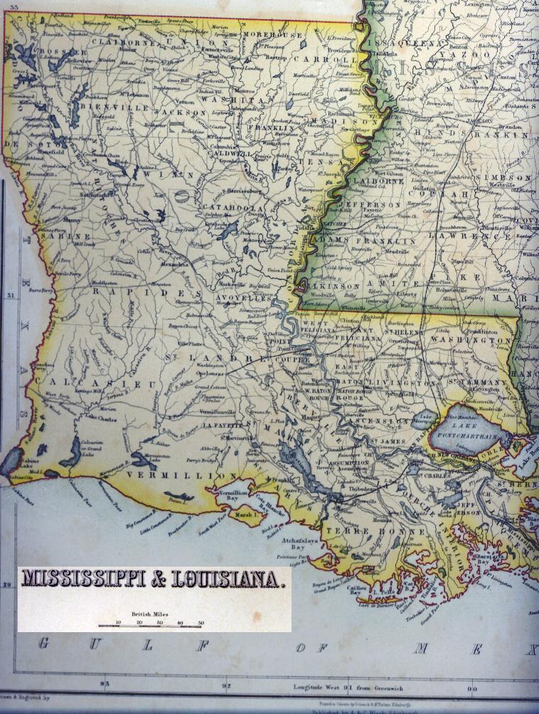 Louisiana 1855 (British) — 206k. This interesting map was published in Edinburgh, Scotland by A & C Black probably about 1855. The scale is in "British" miles.
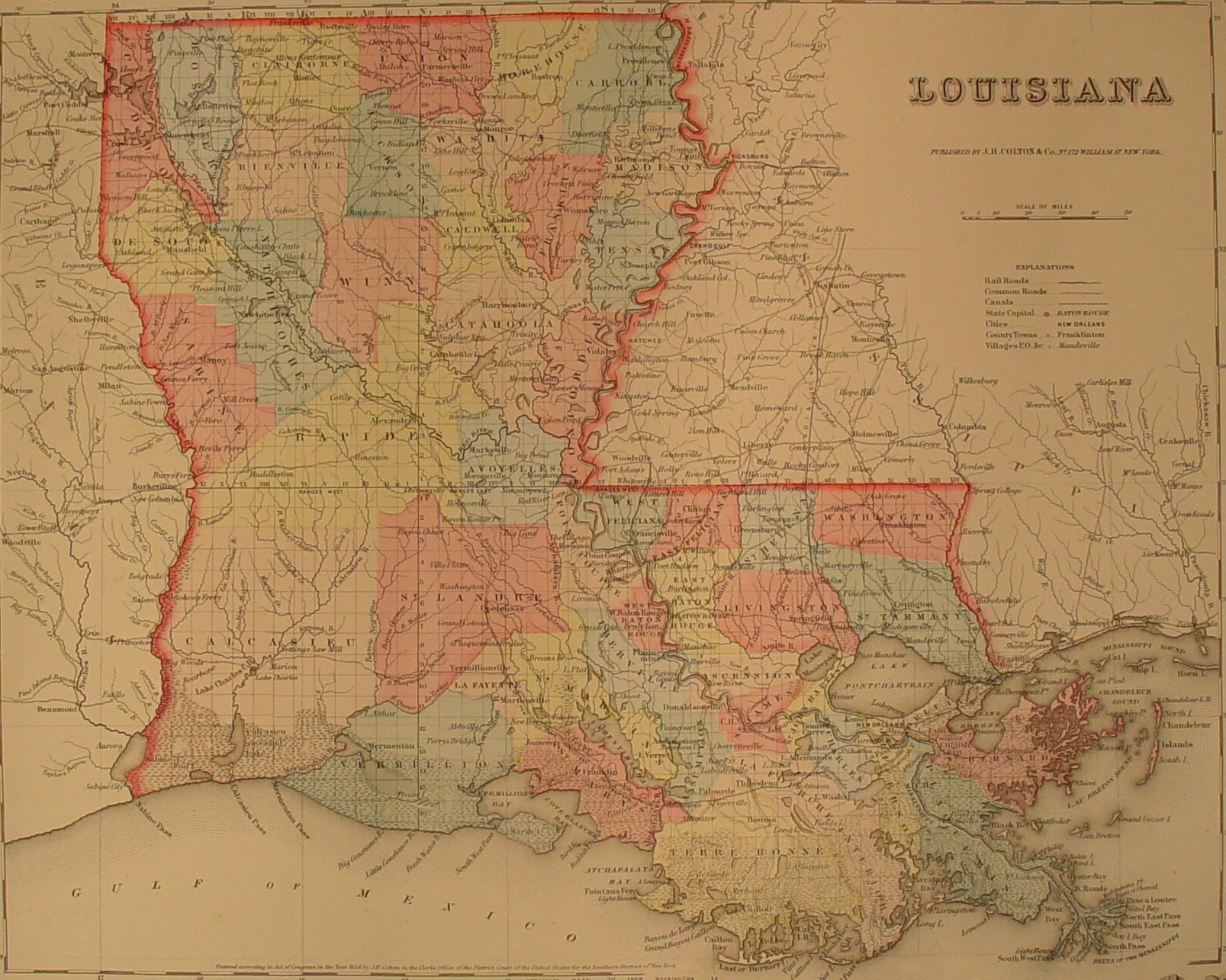 Louisiana 1856 — 400k. Published by J. H. Colton & Co., New York. Courtesy of F. Dean Williams .
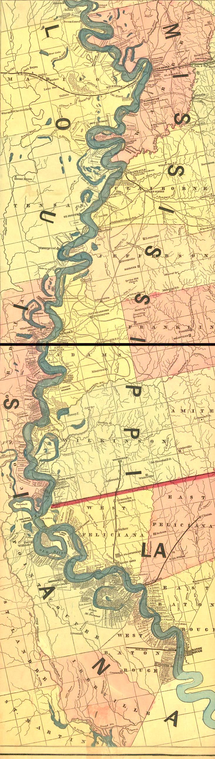
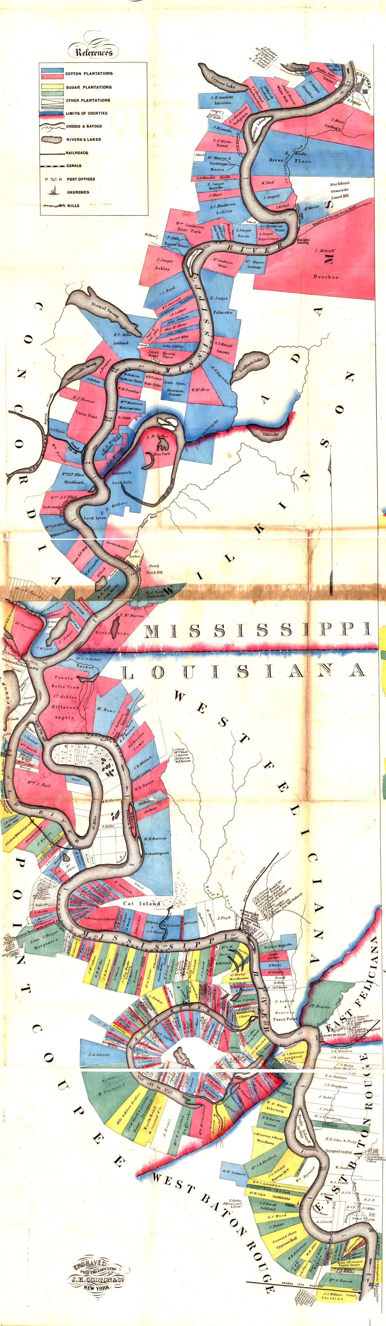 LA-MS 1858— 962k. Natchez to Baton Rouge showing land owners. Modified from Norman's chart of the lower Mississippi River, by A. Persac. Engraved, printed & mounted by J. H. Colton & Co., New York. Library of Congress.
 LA-MS 1858— 1,136k. Baton Rouge to New Orleans showing land owners. Modified from Norman's chart of the lower Mississippi River, by A. Persac. Engraved, printed & mounted by J. H. Colton & Co., New York. Library of Congress.
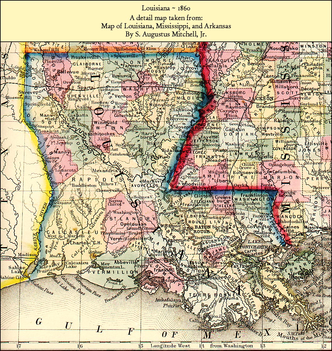 Louisiana 1860 — 632k.Map from an 1860 Atlas, published in Philadelphia by S. Augustus Mitchell.
 Louisiana 1861 — 396k. Alluvial Map showing railroads and alluvial deposits. From Library of Congress.
 Louisiana 1862— 656k. From "Lloyd's new military map of the Border & Southern states Drawn by Edward S. Hall. Waters & Son, engravers. Battlefields are marked by red lines and strategic places by red dots. New York, H. H. Lloyd & Co., 1862." From Library of Congress.
 Mississippi River-Milliken’s Bend to Baton Rouge 1862 — 532k. Fairly detailed. Shows some landowners and plantations. Published by H. L. Lloyd & Co., New York. From Library of Congress.
 Mississippi River-Baton Rouge to Gulf 1862 — 505k. Fairly detailed. Shows some landowners and plantations. Published by H. L. Lloyd & Co., New York. From Library of Congress.
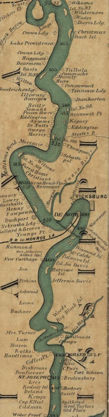
 Mississippi River-Cairo, IL to the Gulf 1863 — 453k. Lloyd’s New Map of the Mississippi. Published by H. L. Lloyd & Co., New York. From Library of Congress.
 Mississippi River - Greenville to St. James 1863 — 508k. Modified from Panorama of the Mississippi Valley : and its fortifications by F.W. Boell. Shows towns, railroads, river landings, some plantations, etc. Library of Congress.
 Mississippi River - St. James to Gulf 1863 — 493k. From Panorama of the Mississippi Valley : and its fortifications by F.W. Boell. Library of Congress.
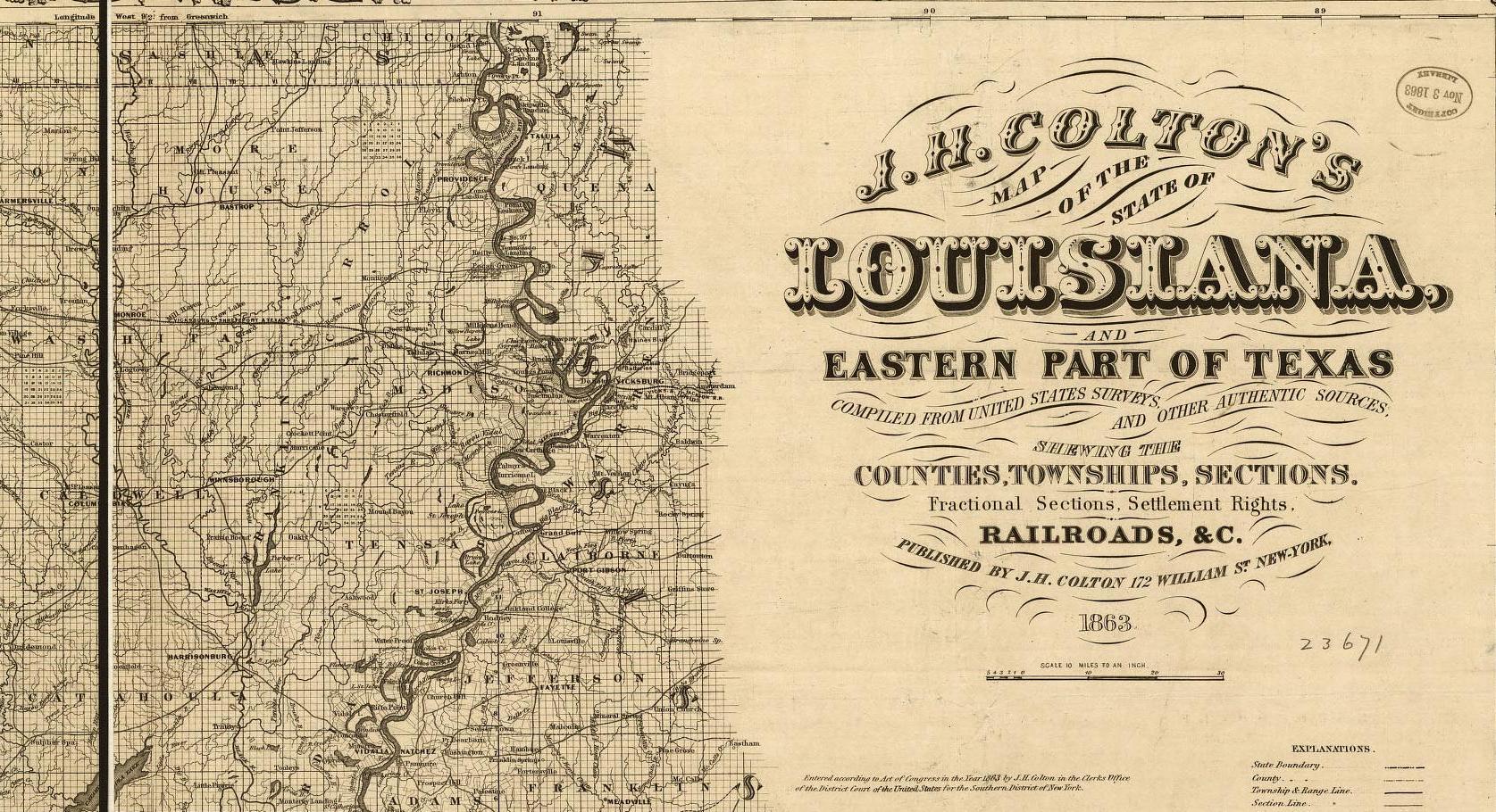
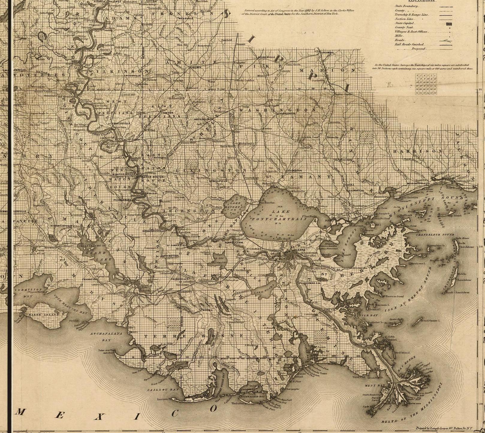
Louisiana 1863 — Railroad map also showing detailed section, township & range information. Note: This map is so large that it has been split into Northeast —471k., Northwest — 351k., Southeast — 844k. and Southwest
— 409k. Published by J. H. Colton, New York, 1863. From Library of Congress.
Northwest — 351k.
 Northeast —471k. Southwest
— 409k Southeast — 844k.
Northeast —471k. Southwest
— 409k Southeast — 844k.

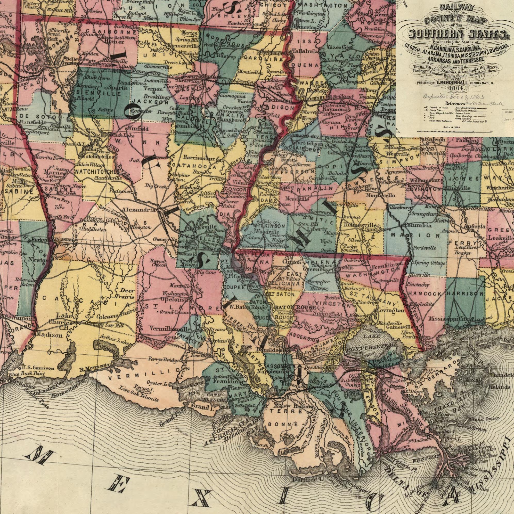 Louisiana 1864 — 902k. From "Railroad and County Map of the Southern States Exhibiting all the Towns, Villages, Stations and Landings; the Rivers, Railways, Common Roads, Canals, throughout these States. Published by E. Mendenhall, Cincinnati, O., 1864." From Library of Congress.
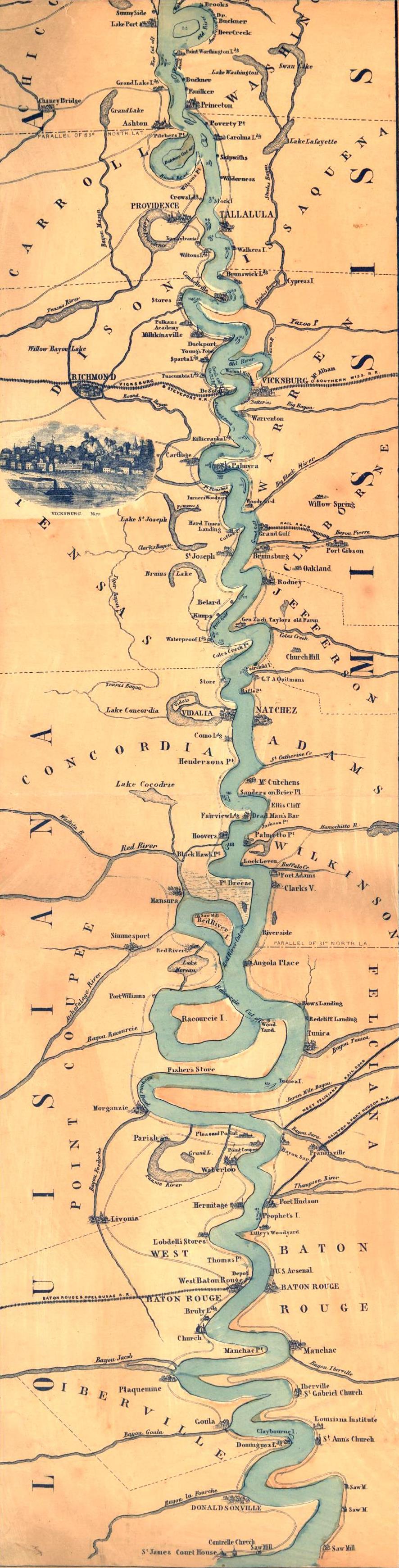
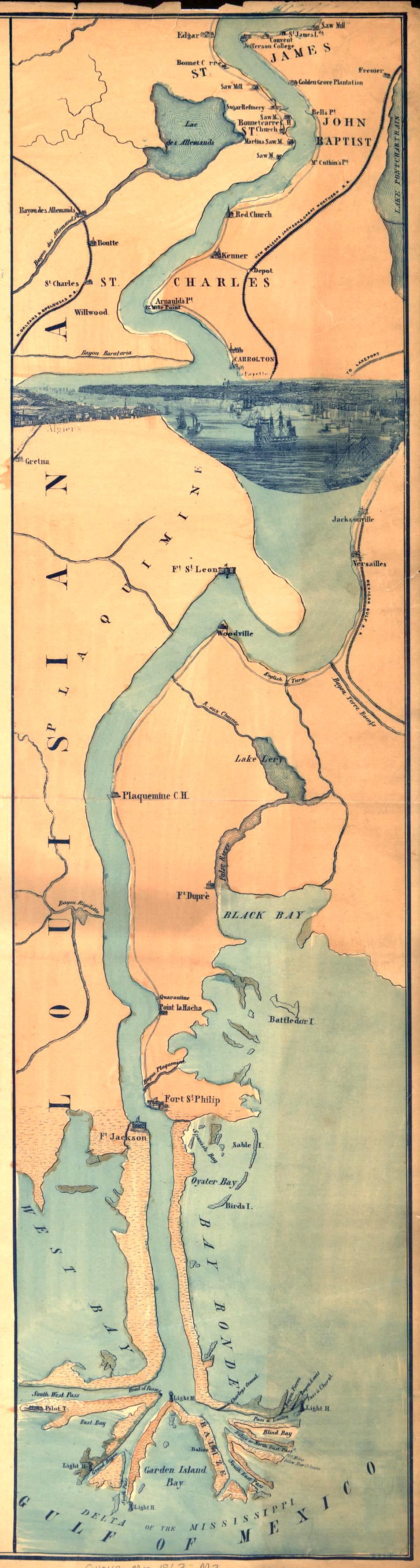
 Mississippi River 1866 LA Line to Waterproof, LA — 103K. Ribbon map designed for a steamboat traveler. Published by Coloney and Fairchild, St. Louis, Mo. 1866. Shows distances, landings and some landowners. From Library of Congress.
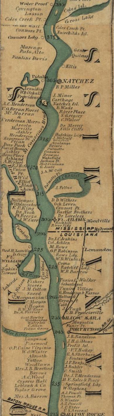 Mississippi River 1866 Waterproof, LA to Baton Rouge — 116K. Same as above. From Library of Congress.
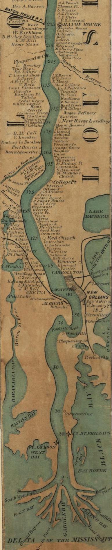 Mississippi River 1866 Baton Rouge to Gulf — 135K. Same as above. From Library of Congress.
 Louisiana 1874 Flood — 637K. Shows effects of 1874 Mississippi River Flood. New Orleans Times-Picayune. From Library of Congress.
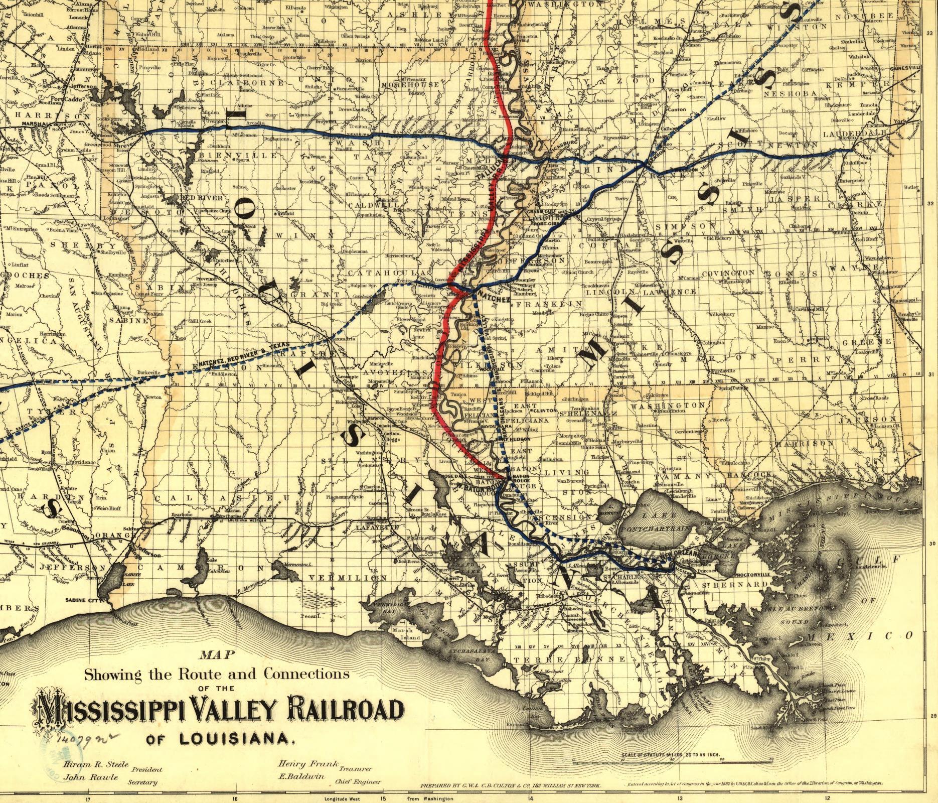 Louisiana 1882 — 866k. From "Map Showing Route and Connections of the Mississippi Valley Railroad of Louisiana. G. B. and C. B. Colton Co., New York 1882." From Library of Congress.

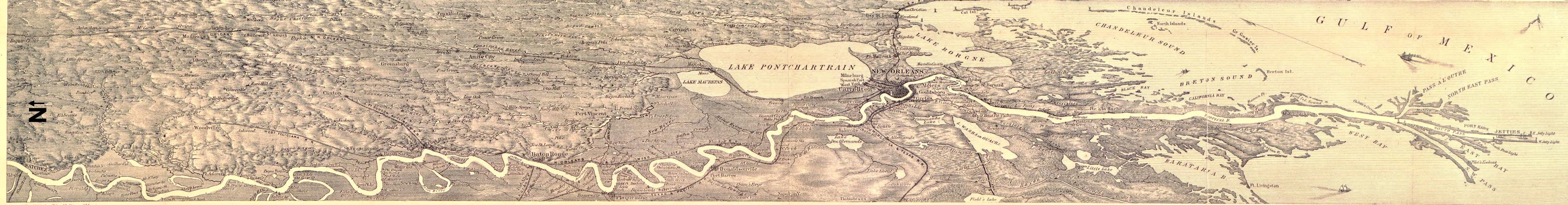
Louisiana 1884 — 898k. Memphis to Natchez Louisiana 1884 — 775k. Natchez to Gulf
Bird's-eye view of the Mississippi River from Memphis to Natchez. Drawn & engraved by Edward Molitor, T.E. An interesting overhead view covering a swath approximately 100 miles wide showing detailed towns, lakes & streams, railroads, etc. From Library of Congress.
 Louisiana 1885 — 564k. By George F. Cram, Engraver and Publisher, Chicago, IL. Courtesy of F. Dean Williams .
 Louisiana 1893 — 2,388k. Shows Cities, Towns and Parish lines. Courtesy of Elaine Vechorik, Sturgis Sugar Factory, Sturgis, MS.
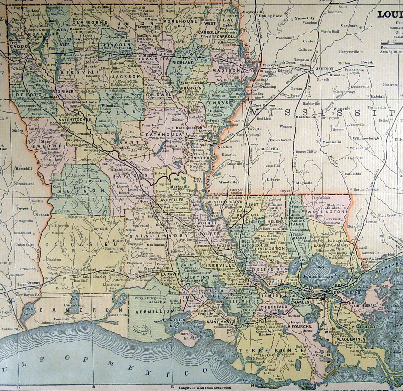
 Louisiana 1895 — 1,091k. Rand McNalley 1896. From Library of Congress.
 Louisiana Indian Land Cessions 1899 — 516K. Cessions of Indian Lands from the time of the establishment of the U.S. Government to 1894. For more information click here. Also shows townships and ranges. From Indian Land Cessions in the United States,
U.S. Government Printing Office 1899.
Louisiana Indian Land Cessions 1899 — 516K. Cessions of Indian Lands from the time of the establishment of the U.S. Government to 1894. For more information click here. Also shows townships and ranges. From Indian Land Cessions in the United States,
U.S. Government Printing Office 1899.
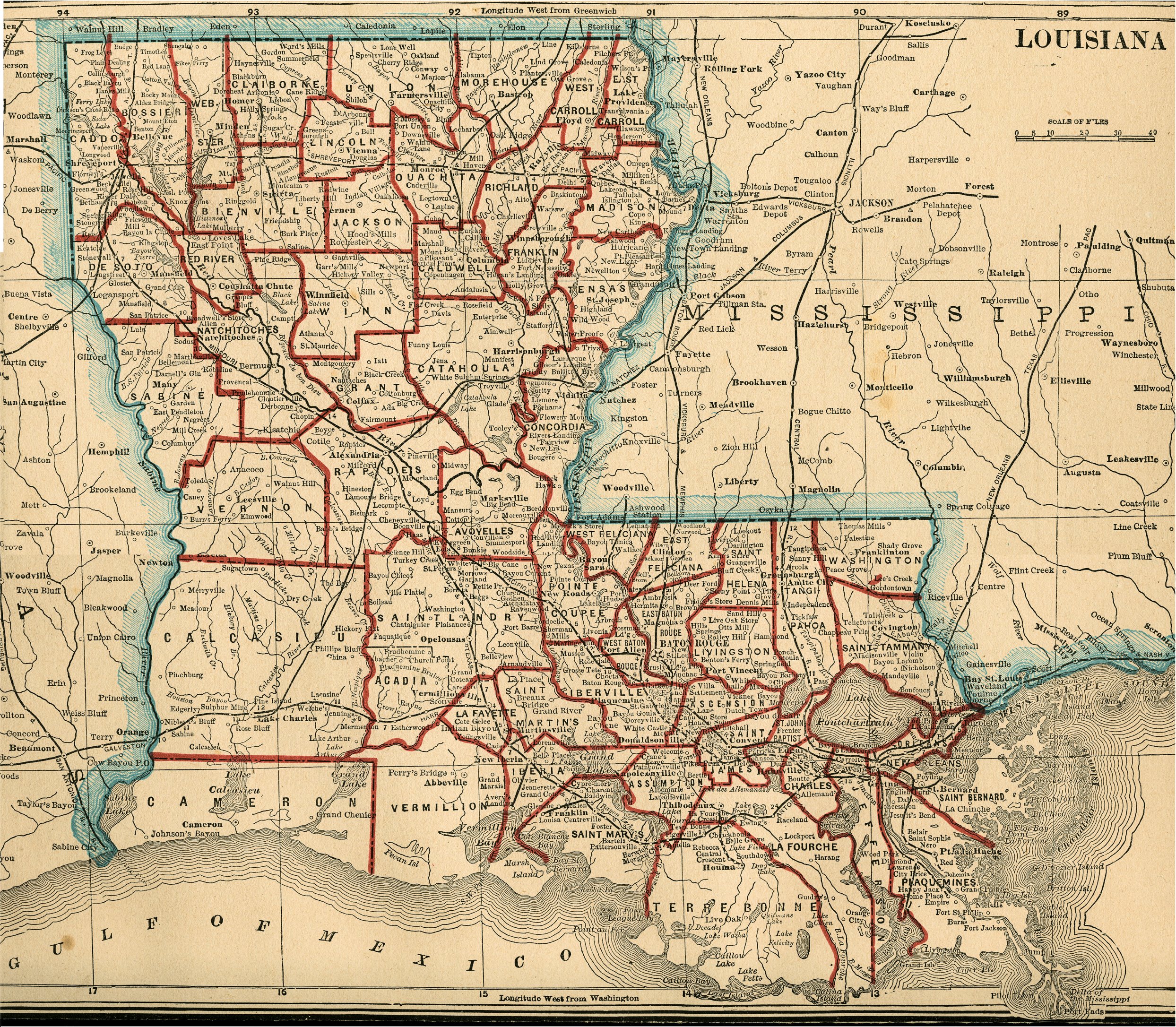
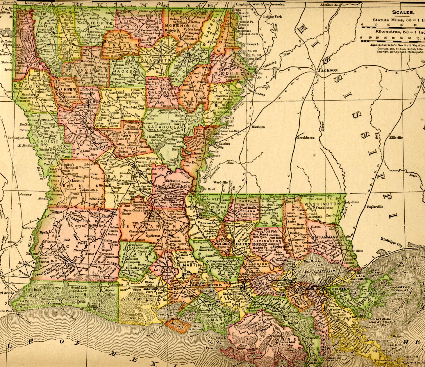 Louisiana 1907 — 570k. Map from Rand McNalley & Co.’s New Ideal State and County Survey and Atlas 1907.
 1927 Mississippi River Flood —1,058k. Detailed map of the areas affected by the 1927 Flood showing flooded areas and field of operations. Prepared by the U. S. Coast and Geodetic Survey from data supplied by the U. S. Army Corps of Engineers. Courtesy of Brad Edmondson.
![]()
![]()
For individual 1895 parish maps click here.
For current detailed Parish Highway Maps click here, scroll down to the Parish Maps and select the desired parish. The Parish Highway Maps are large (4-15 Mb) maps in PDF format. They can either be read online or downloaded and saved.
Carroll Parish:
 Carroll Parish 1848 — 762k. Part of "La Tourrette's 1848 reference map of the state of Louisiana : from the original surveys of the United States, which show the townships, sections, or mile squares, Spanish grants, settlement rights & c., also the plantations with the owners names engraved thereon / compiled and published by John La Tourrette, New Orleans, LA. ; designed and engraved by Peter J. Grassner, A.D.
1848." From Library of Congress.
Carroll Parish 1848 — 762k. Part of "La Tourrette's 1848 reference map of the state of Louisiana : from the original surveys of the United States, which show the townships, sections, or mile squares, Spanish grants, settlement rights & c., also the plantations with the owners names engraved thereon / compiled and published by John La Tourrette, New Orleans, LA. ; designed and engraved by Peter J. Grassner, A.D.
1848." From Library of Congress.
 Carroll Parish 1853 — 773k. Same as above, except 1853 version. From Library of Congress.
DeSoto and Sabine Parishes:
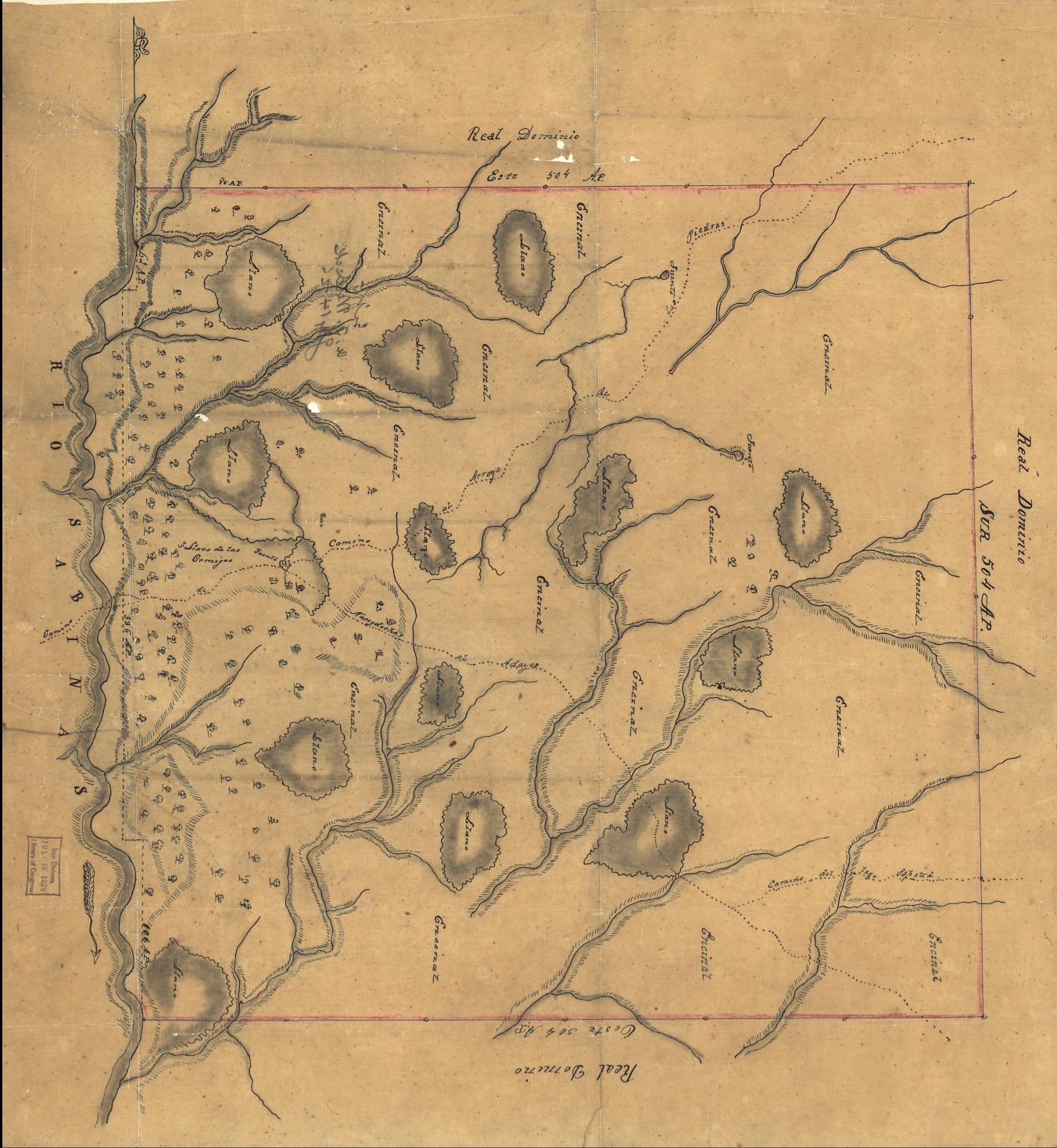 Las Ormigas Land Grant 180? — 345k. Later known as the Arroyo Hondo Grant this pen and ink watercolor Spanish map shows a portion of DeSoto and Sabine parishes in the early 1800's. At the time the map was made this was an area of dispute between the United States and Spain. From Library of Congress.
Madison Parish:
Madison Parish Patentee Map Index —These are color-coded maps showing properties bought from the US General Land Office (GLO) by
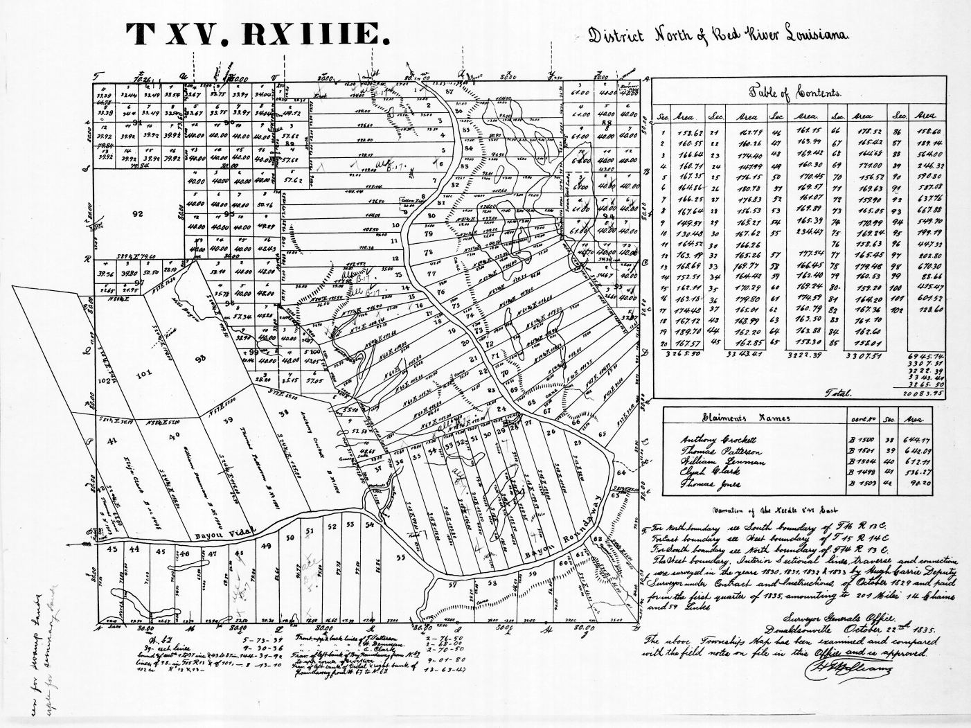
 Madison Parish’s earliest landowners. Most of these tracts were purchased during the middle 1800’s. Each township is mapped separately on the original 1820-1830 surveys. Each tract shows the original owner and the date the tract was purchased. The individual maps are hyperlinked to the Index which shows the entire parish. The map to the left is an example of the township maps. It shows the original landowners in Township 15 North - Range 13 East. Click on it (maybe twice) to enlarge it. Twenty-six townships are available from Township 14 North - Range 9 East in the southwestern part of the parish through Township 18 North - Range 14 East in the northeastern part. For more on this and a list of the original landowners click here.
 Madison Parish West 694k. Current map showing Plantation locations circa 1891
 Madison Parish East — 851k. Current map showing Plantation locations circa 1891
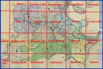
 Madison Parish Ward Boundaries — 799k.
Current map showing Ward boundaries.
Madison Parish Ward Boundaries — 799k.
Current map showing Ward boundaries.
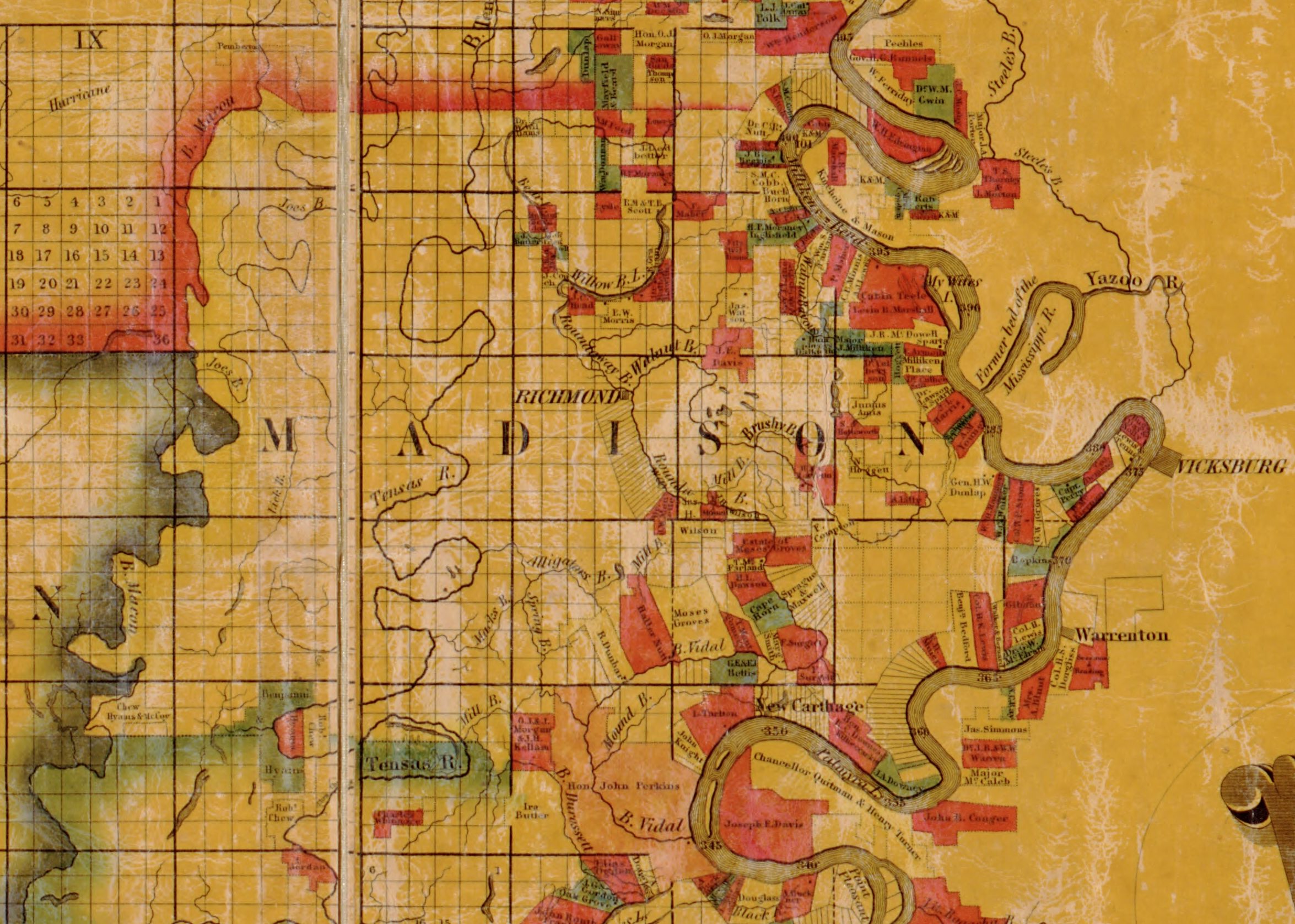 Madison Parish 1848 — 575k. Part of "La Tourrette's 1848 reference map of the state of Louisiana : from the original surveys of the United States, which show the townships, sections, or mile squares, Spanish grants, settlement rights & c., also the plantations with the owners names engraved thereon / compiled and published by John La Tourrette, New Orleans, LA. ; designed and engraved by Peter J. Grassner, A.D. 1848." From Library of Congress.
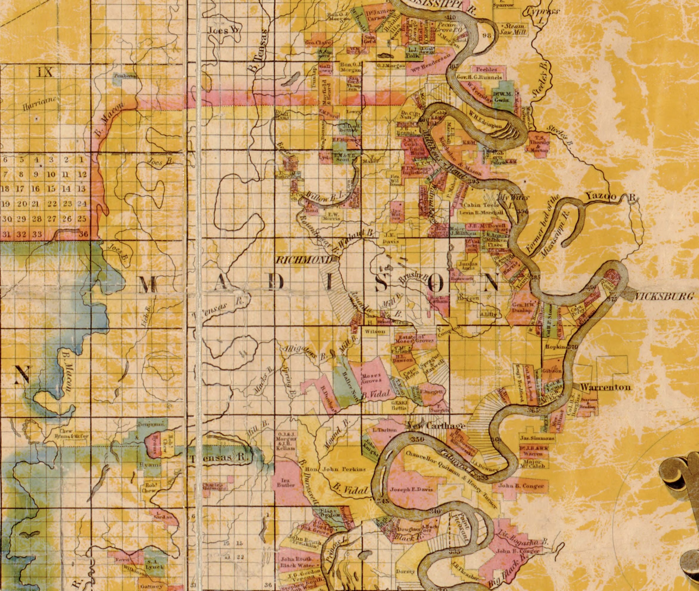 Madison Parish 1853 — 877k. Same as above, except 1853 version. From Library of Congress.
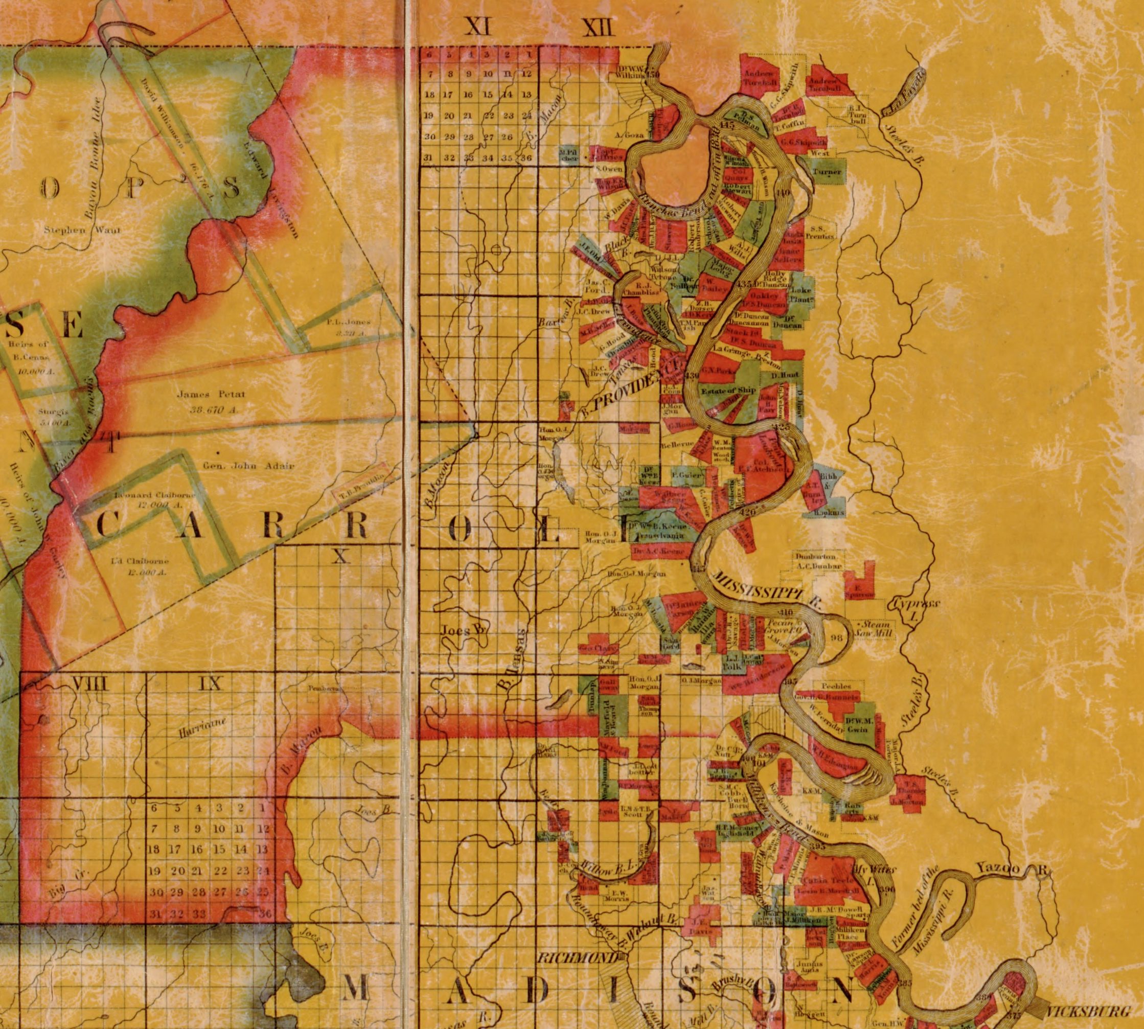
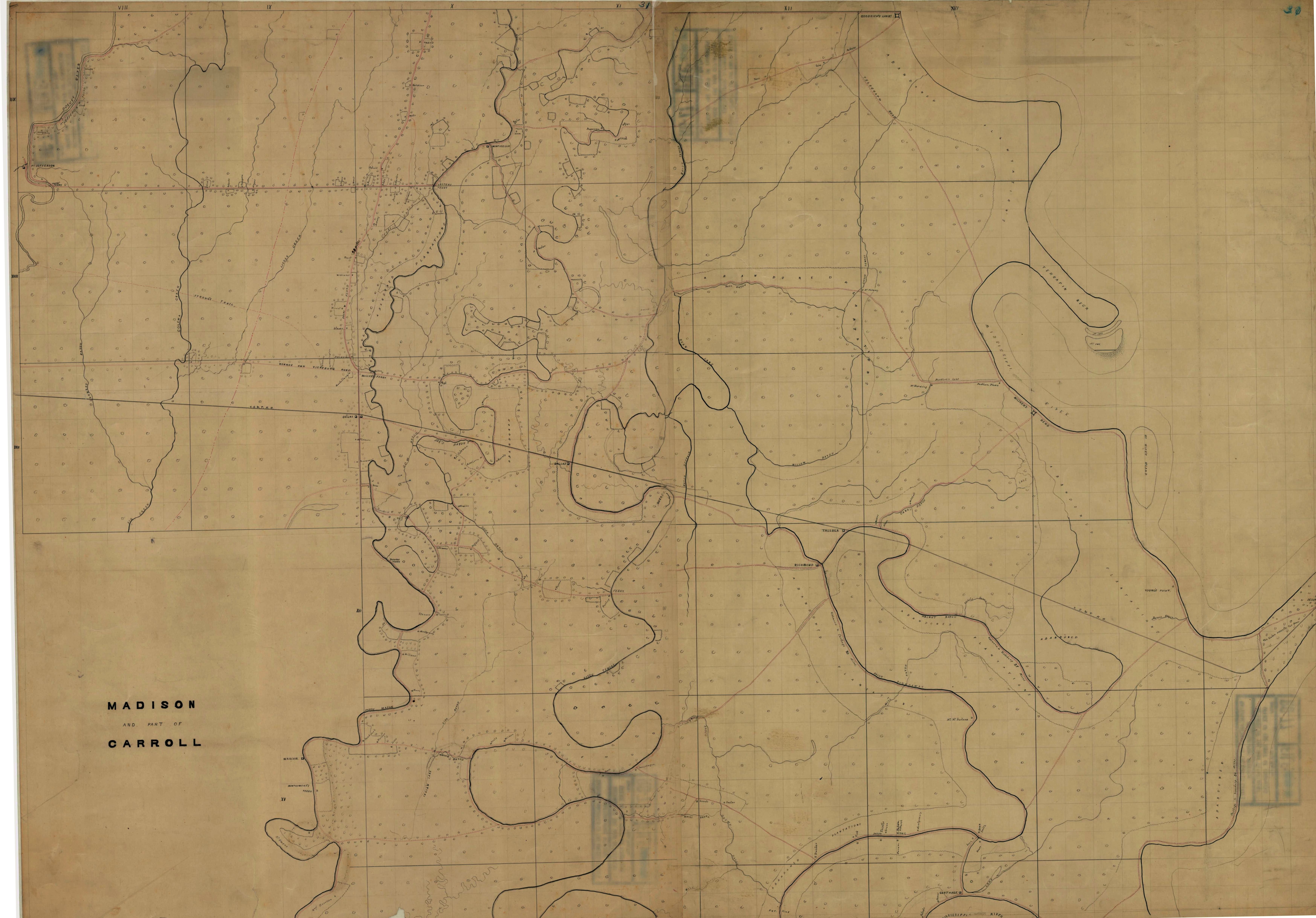 Madison Parish 1862-63 — 2,653k. Confederate military map captured by Union forces during 1862-63. Map shows plantation owners, abandoned plantations, roads, villages, rivers, etc. Probably a forerunner of the Grant’s March map in the Civil War section below. Also shows portions of Carroll and Richland Parishes. Courtesy of the USGS National Wetlands Research Center.
 Madison
Parish 1891 — 5,320k. Shows
plantation names as well as landowner's names. From Library of Congress.
Madison
Parish 1891 — 5,320k. Shows
plantation names as well as landowner's names. From Library of Congress.
 Madison Parish Topographic Maps —Detailed (7.5' Quads) USGS Topographic Maps

Early 1800's Map Showing Madison Parish's First Landowners — 3,142k. Shows original landowners (Patentees).
 Madison Parish 1875 Plantation & Ownership Map — 2,899k. Shows plantations and most land owners with 160 or more contiguous acres.
 Madison Parish 1903 Plantation & Ownership Map — 2,678k. NOTE: The 1903 map was made primarily to show the vast holdings (shown in red) of the 70,000 acre Ashly Co. Ltd of Dundee, Scotland. Unfortunately, due to the many land description mistakes and omissions in the 1903 tax rolls, some property locations may be totally unreliable.
 Madison Parish 1943 Plantation & Ownership Map — 2,820k. Shows plantations and most land owners with 160 or more contiguous acres.
 Madison Parish 1979 Ownership Map — 2,714k. Shows most land owners with 160 or more contiguous acres.
Tensas Parish:
 Tensas Parish 1848 — 575k. Part of "La Tourrette's 1848 reference map of the state of Louisiana : from the original surveys of the United States, which show the townships, sections, or mile squares, Spanish grants, settlement rights & c., also the plantations with the owners names engraved thereon / compiled and published by John La Tourrette, New Orleans, LA. ; designed and engraved by Peter J. Grassner, A.D. 1848." From Library of Congress.
 Tensas Parish 1853 — 677k. Same as above, except 1853 version. From Library of Congress.
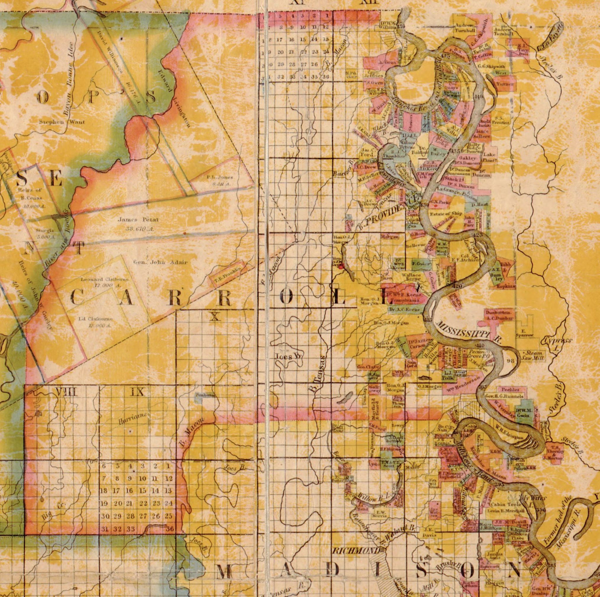
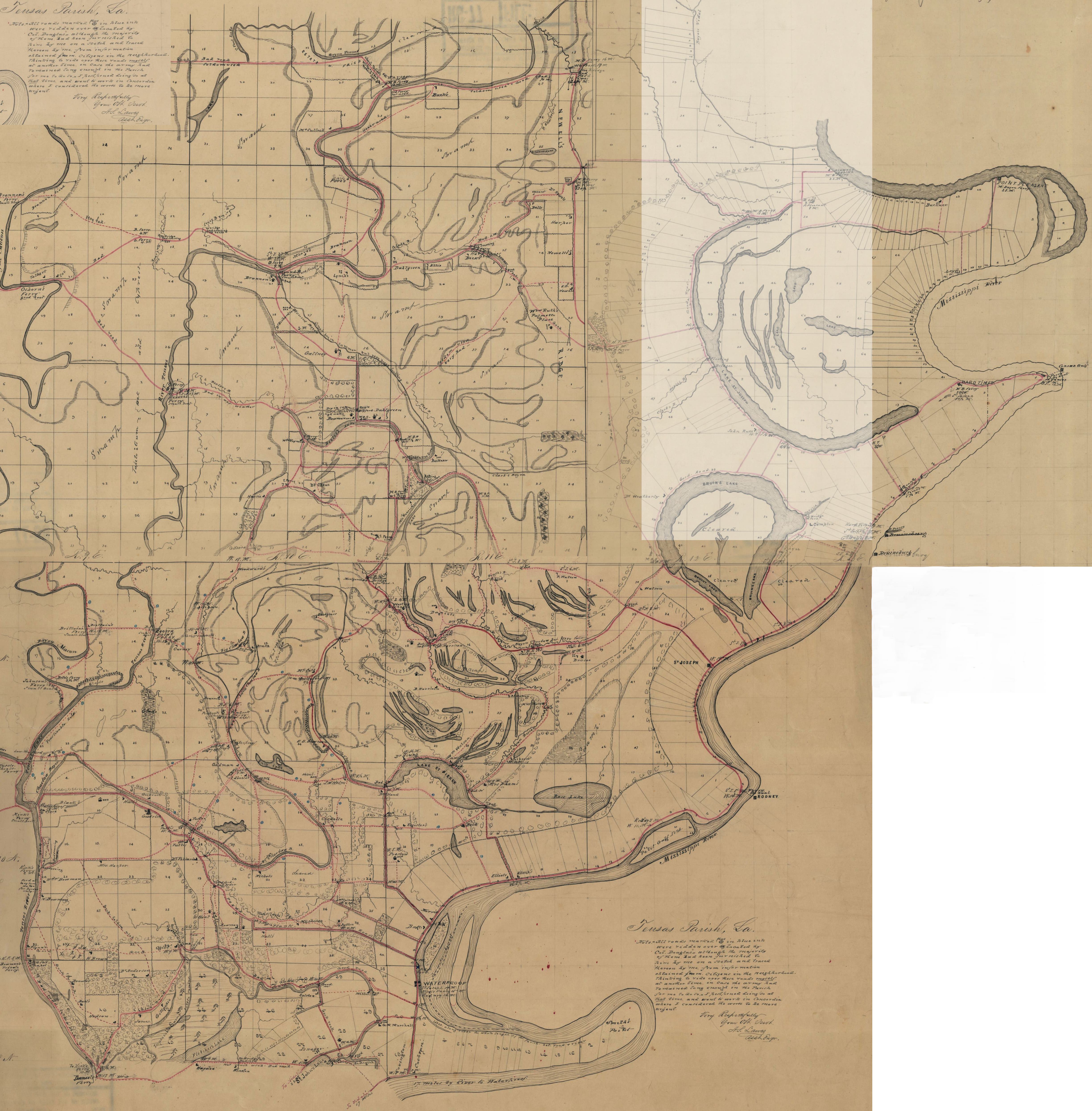 Tensas Parish 1862-63 — 2,889k. Confederate military map captured by Union forces during 1862-63. Map shows plantation owners, abandoned plantations, roads, road conditions, villages, rivers, etc. Probably a forerunner of the Grant’s March map in the Civil War section below. Courtesy of the USGS National Wetlands Research Center.
![]()
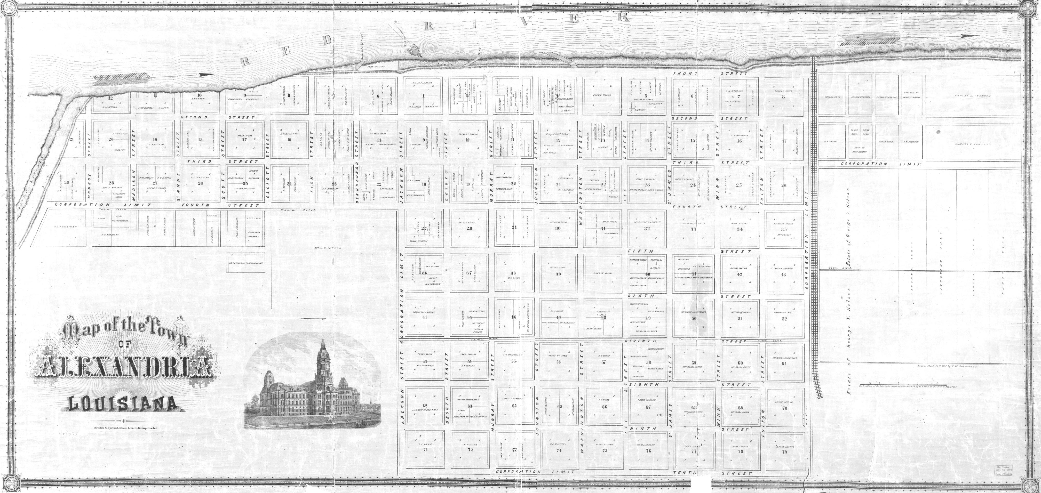 Alexandria 1872 — 1,142k. "Map of the Town of Alexandria, Louisiana. Braden & Burford, Steam Lith. Indianapolis, Ind." Shows streets, lots, lot numbers and lot owners. From Library of Congress.
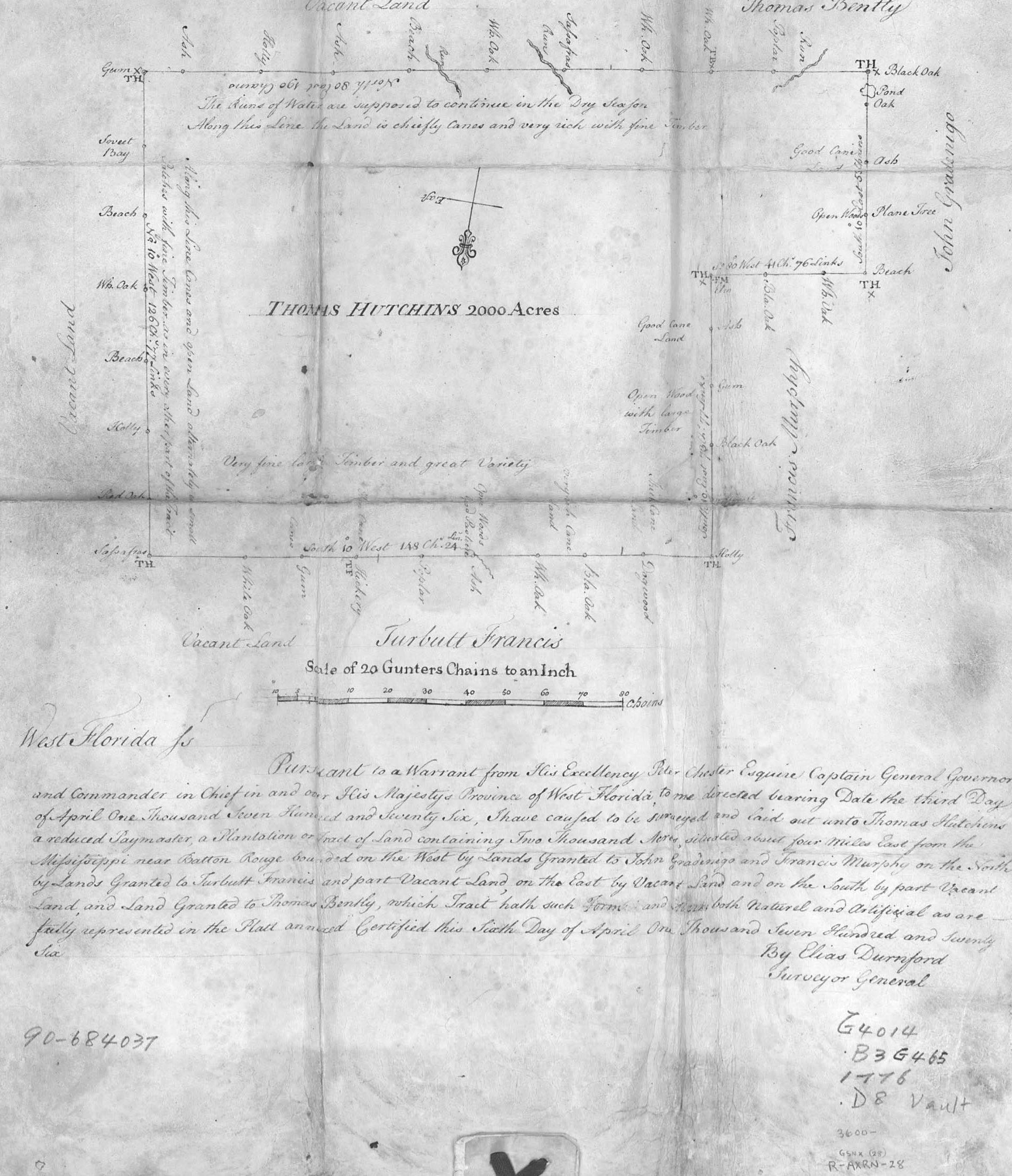 Baton Rouge 1770 — 502k. Map of 2,000 acre Thomas Hutchins Plantation near Baton Rouge. Scaled 20 Gunters Chains to the Inch. From Library of Congress
 Fort Septentrional 1749 — 265k. Map of a fortification on the east side of the Mississippi River below New Orleans. In French. From Library of Congress
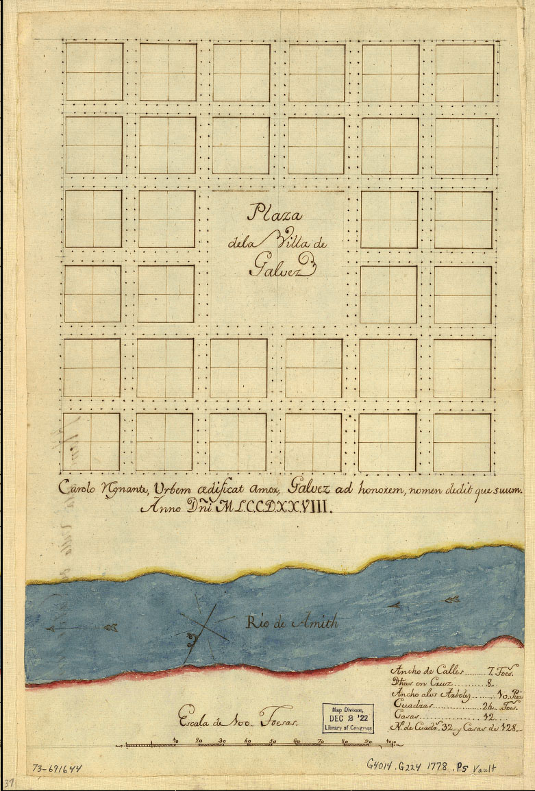 Galvez 1778 — 256k. In Spanish. From Library of Congress
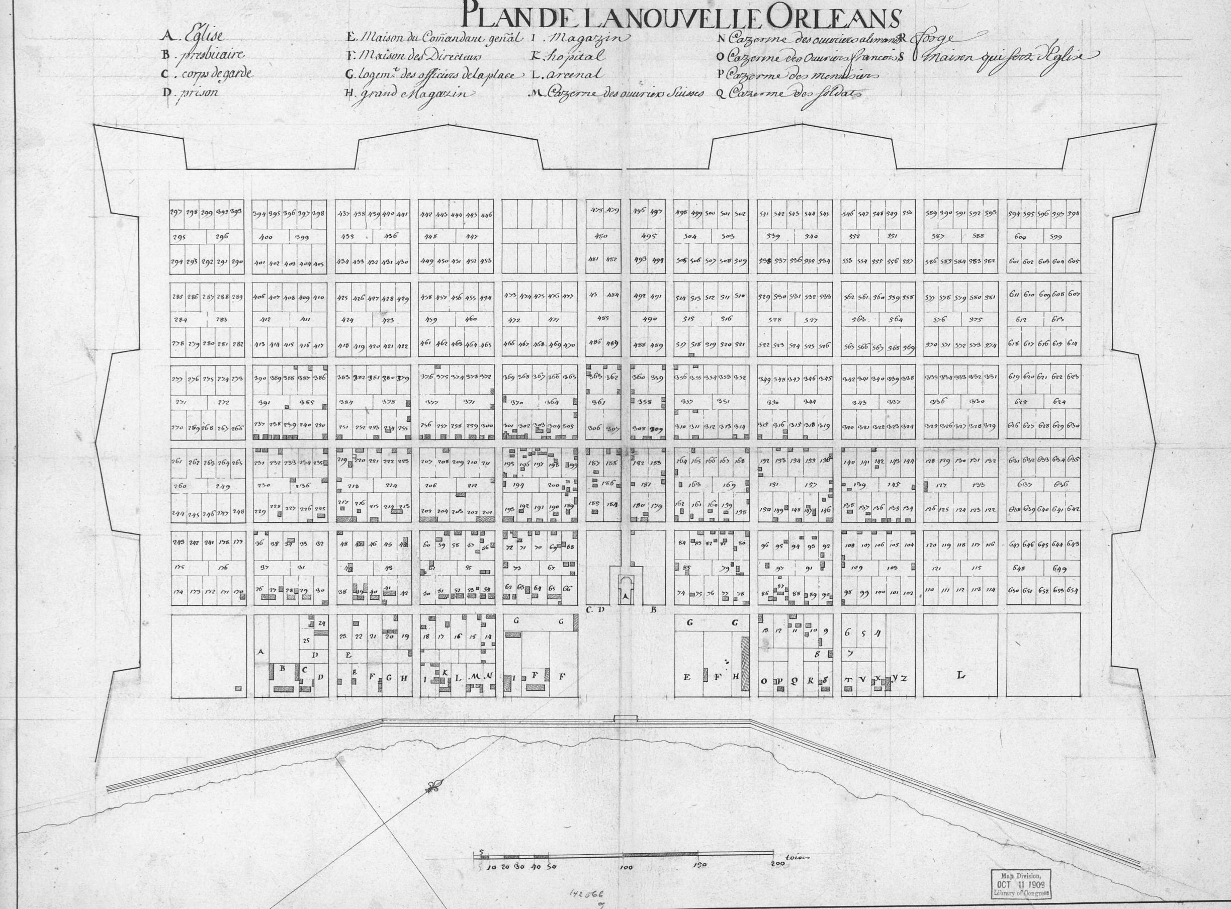 New Orleans 1722 — 650k. "Plan de la Nouvelle Orleans." Shows streets, lots and building locations but no street names. From Library of Congress.
 New Orleans 1731 — 298k. From French National Archives, Paris
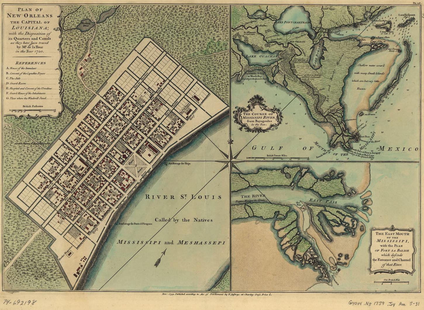
New Orleans 1759 — 442k. British map showing the city as well as part of extreme southeast Louisiana and the east mouth of the Mississippi. From Library of Congress
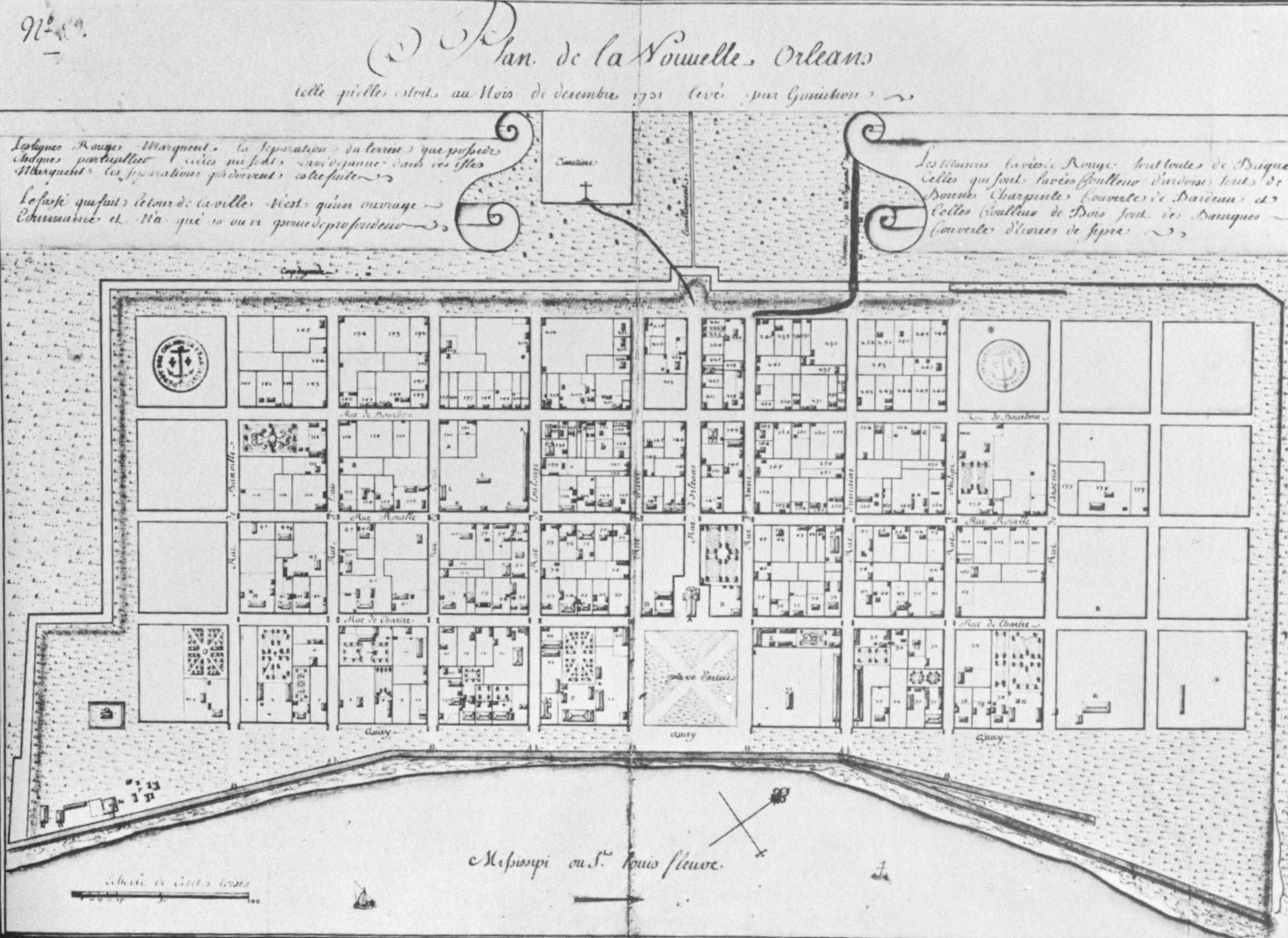
 New Orleans 1764 — 775k. "Plan de la Nouvelle Orleans." Shows streets, street names, lots and building locations. From Library of Congress.
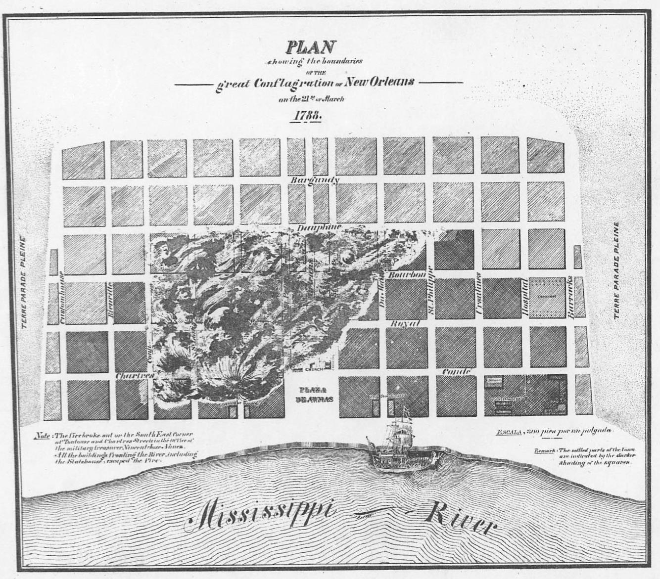 New Orleans 1788 Fire — 329k. "Plan Showing the boundaries of the Great Conflagration of New Orleans on the 21st of March, 1788. From Library of
Congress.
New Orleans 1788 Fire — 329k. "Plan Showing the boundaries of the Great Conflagration of New Orleans on the 21st of March, 1788. From Library of
Congress.
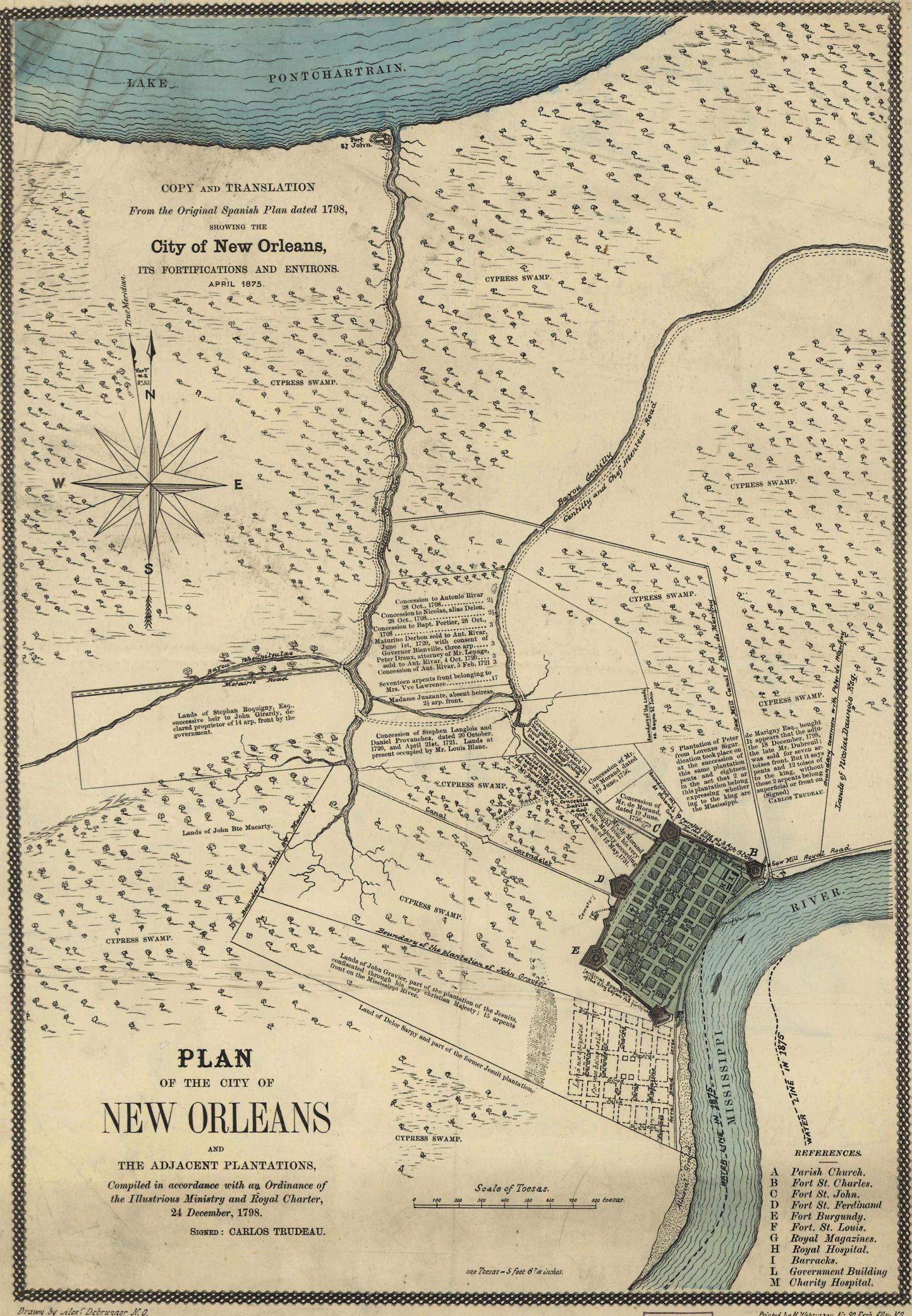 New Orleans 1798 — 688k. "Plan of the City of New Orleans and Adjacent Plantations" Shows plantation ownership. Translated from the original Spanish Plan in 1875. From Library of Congress.
 New Orleans 1815 — 601k. Pen-and-ink and water color showing Bienvenue stretching from Lake Pontchartrain to Lake Borgne. From Library of Congress.
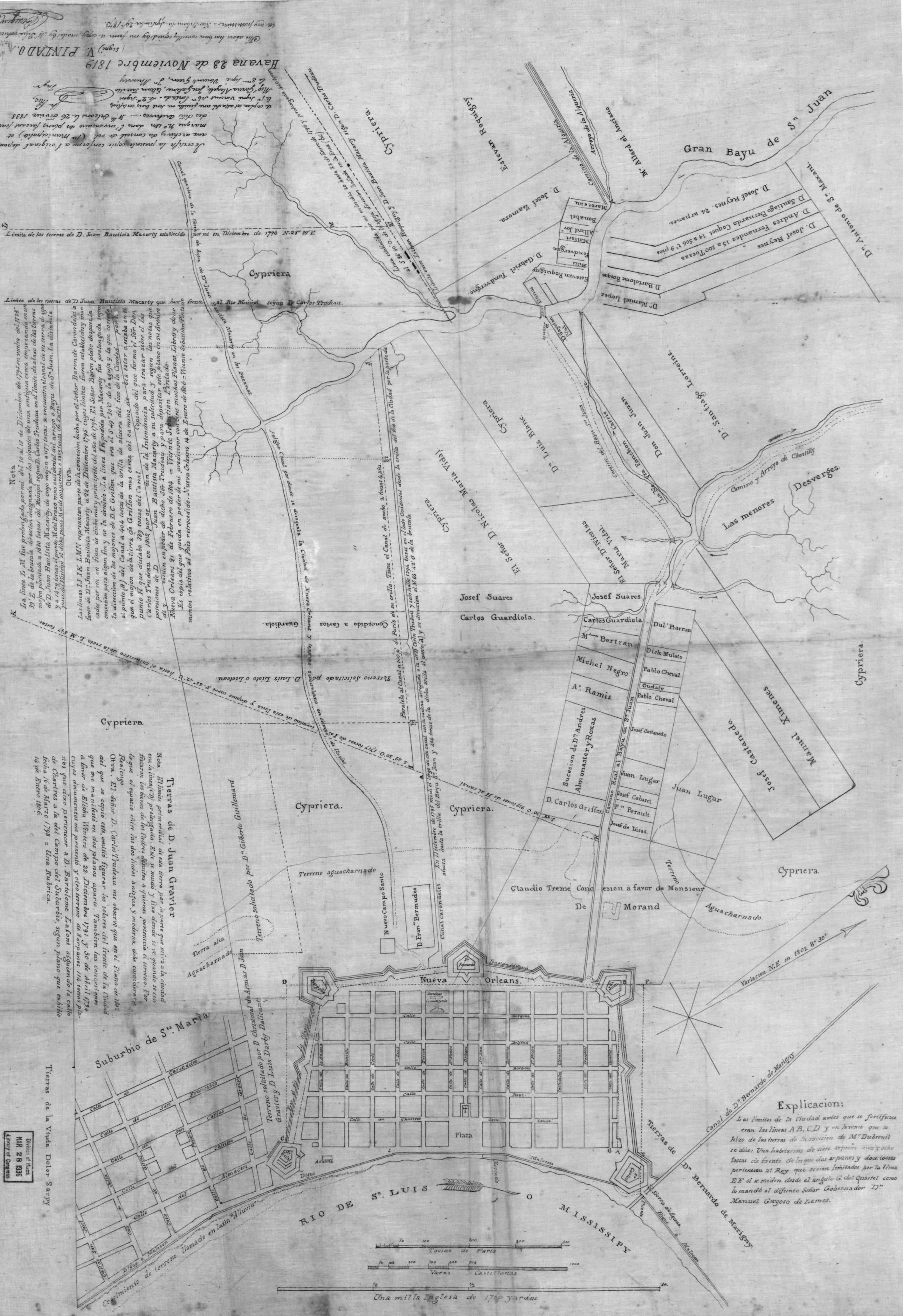 NewOrleans 1819 — 945k. "Nueva Orleans" In Spanish. Shows streets, street names, plantations and plantation owners. From Library of Congress.
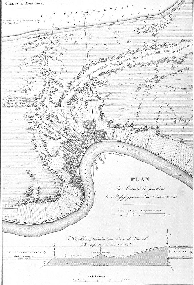 New Orleans 1828 — 174k. Shows Canal from Mississippi River to Lake Pontchatrain. From Bibliotheque National, Paris
 New Orleans 1845 —106k. From Pictorial Advisor
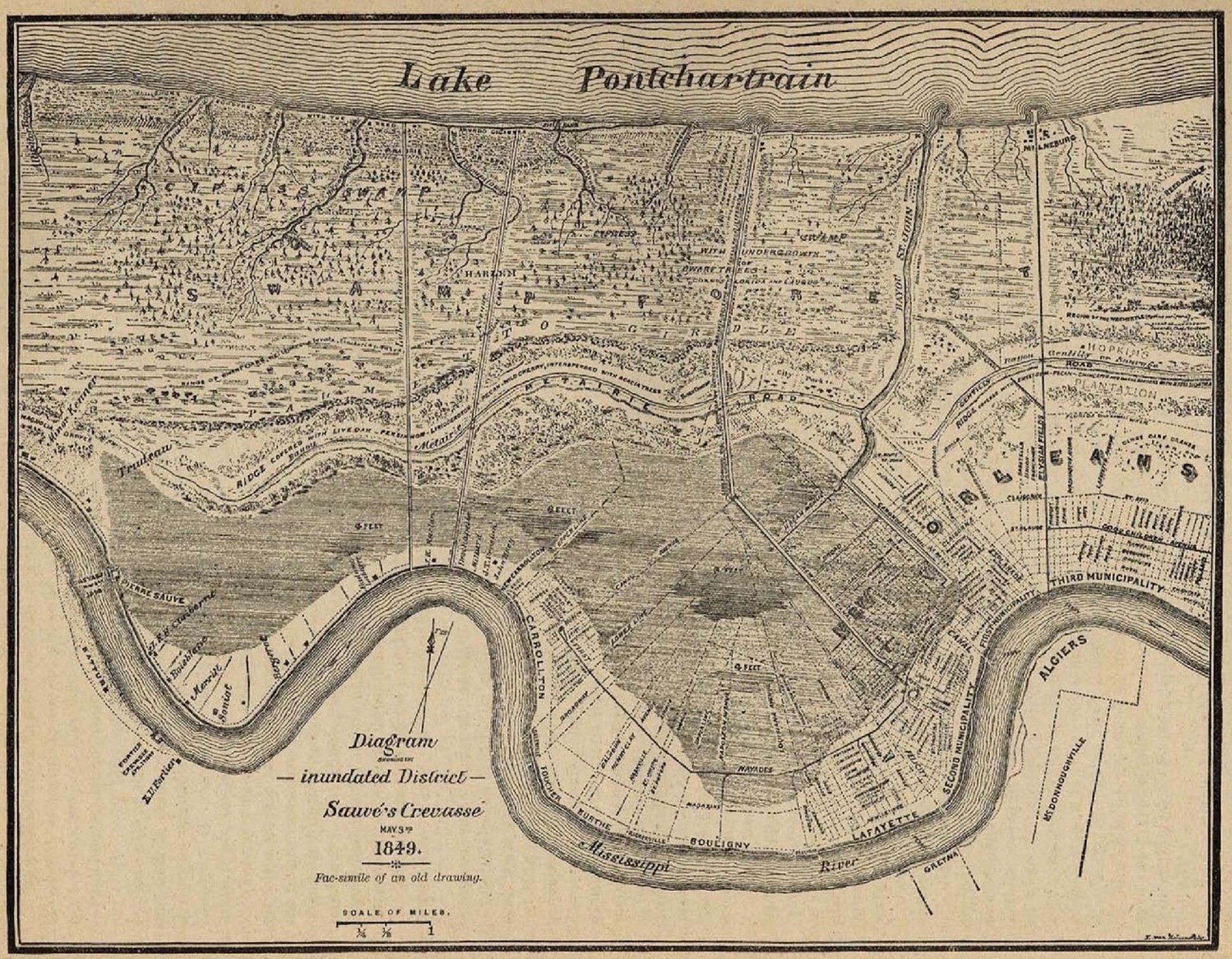 New
Orleans 1849 Flood —
1,083k. Diagram
showing the Inundated District - Sauvé's Crevasse
May 3, 1849. Fac-simile of an old drawing.
New
Orleans 1849 Flood —
1,083k. Diagram
showing the Inundated District - Sauvé's Crevasse
May 3, 1849. Fac-simile of an old drawing.
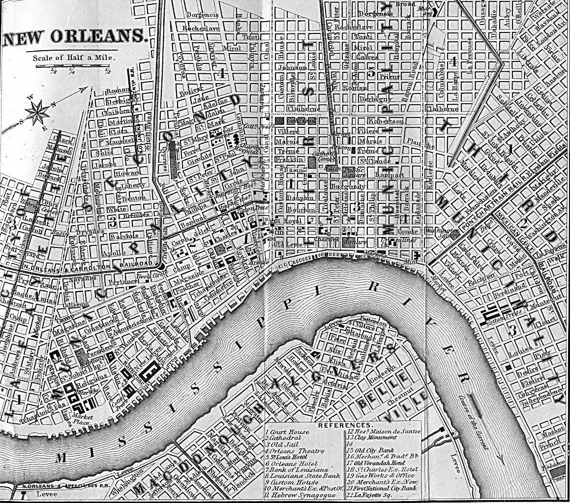 New Orleans 1869 — 540k. From Appleton’s Handbook of American Travel 1869
 New Orleans 1873 — 740k. From Appleton’s Handbook of Southern Travel 1873
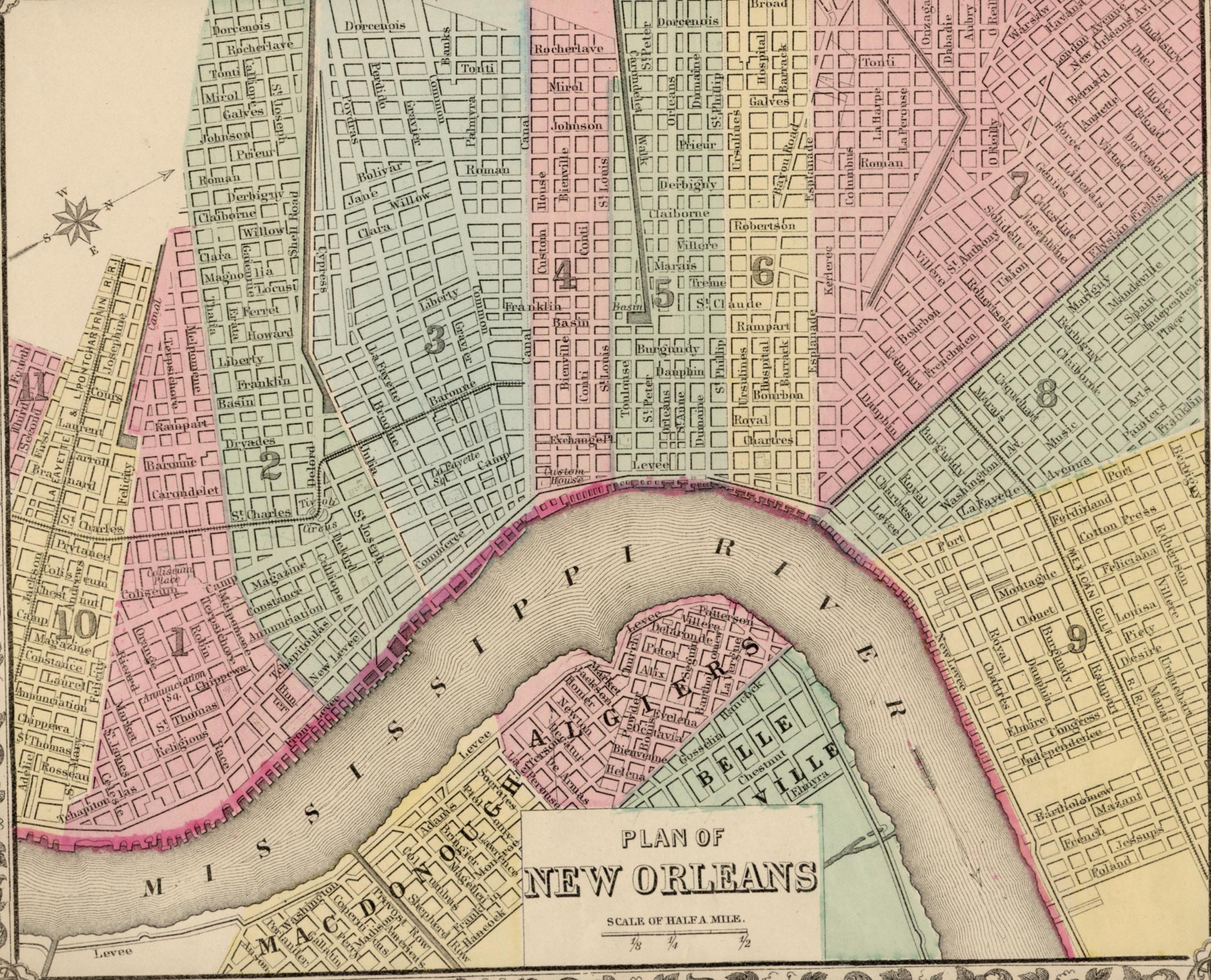 New Orleans 1878 — 784k. Color-coded by Ward. By S. Augustus Mitchell. Original at Choctaw Books, Jackson, MS.
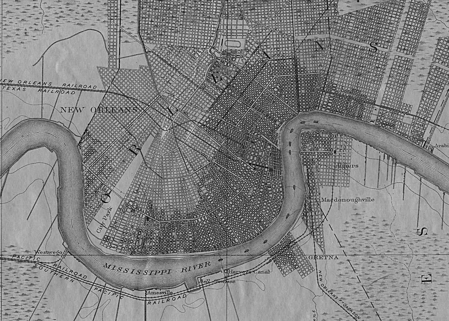 New Orleans 1891 — 602k. From USGS
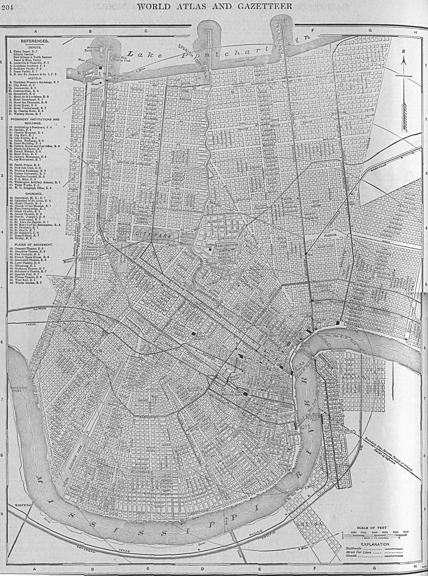 New Orleans 1908 — 852k. From The New Encyclopedia Atlas and Gazetteer of the World 1917
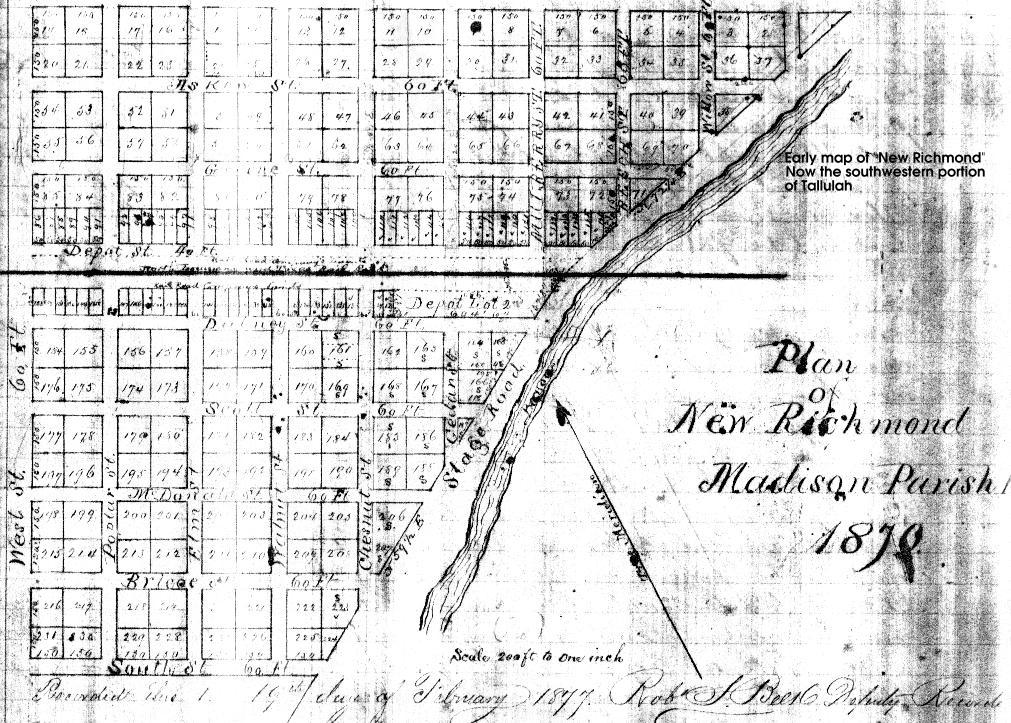 New Richmond 1877 — 235k. Madison Parish. After the original Parish Seat of Richmond was burned to the ground by Union troops in 1863 an attempt was made to resurrect the city at a nearby location. This failed, and the area is now part of Tallulah.
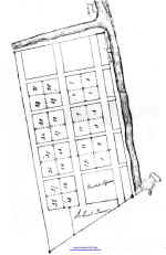 Richmond 1839 — 127k. First Parish Seat of Madison Parish. Burned to the ground by Union troops on June 15, 1863 during the Battle of Richmond in retribution for Federal losses at the June 7, 1863 Battle of Milliken’s Bend. Courtesy of Louis Buckner, Tallulah, LA.
 Shreveport 1920 — 124k. From The Automobile Blue Book
![]()
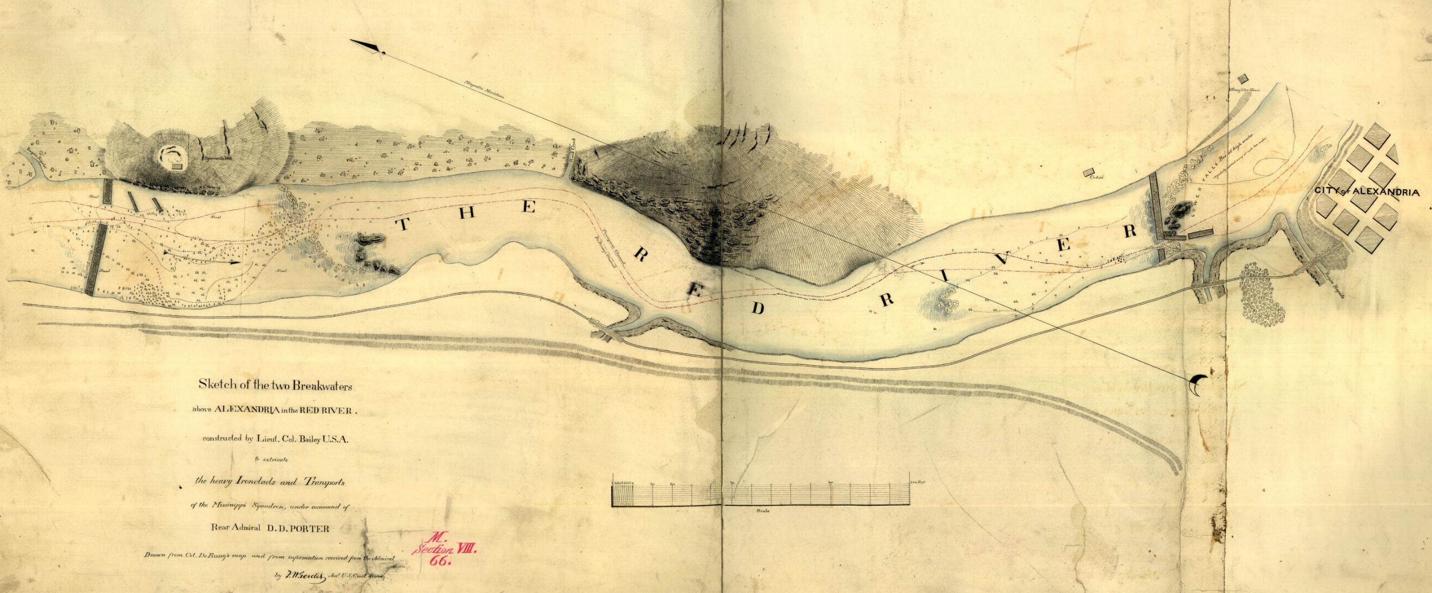 Alexandria 1864 — 422k. Sketch of the two Breakwaters above Alexandria in the Red River constructed by Lieut. Col. Bailey USA to extricate the heavy Ironclads and Transports of the Mississippi Squadron, under the command of Rear Admiral D. D. Porter. From Library of Congress
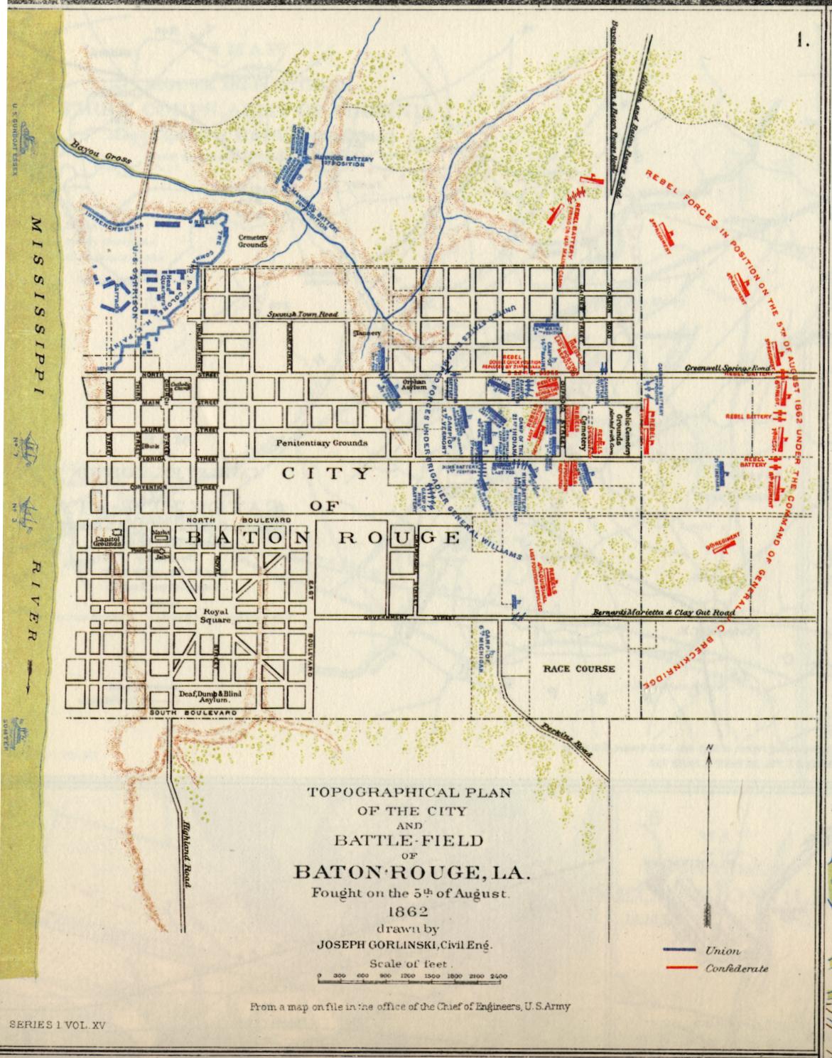 Baton Rouge 1862 — 263k. Shows positions in color of Confederate and Union defenses in the Battle of Baton Rouge on August 5, 1862. From PLATE XXIV – map 1 of the Atlas to Accompany the Official Records of the Union and Confederate Armies 1861-1865. Courtesy of L. Graham Hughes.
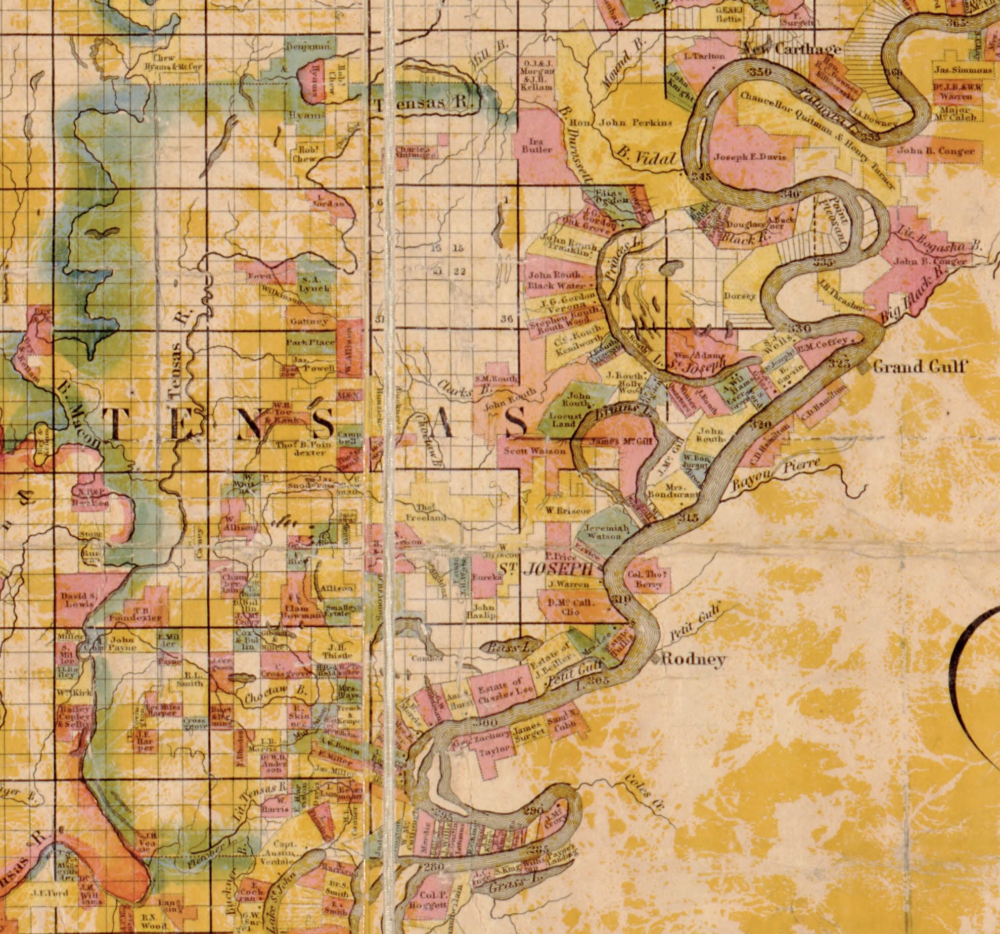
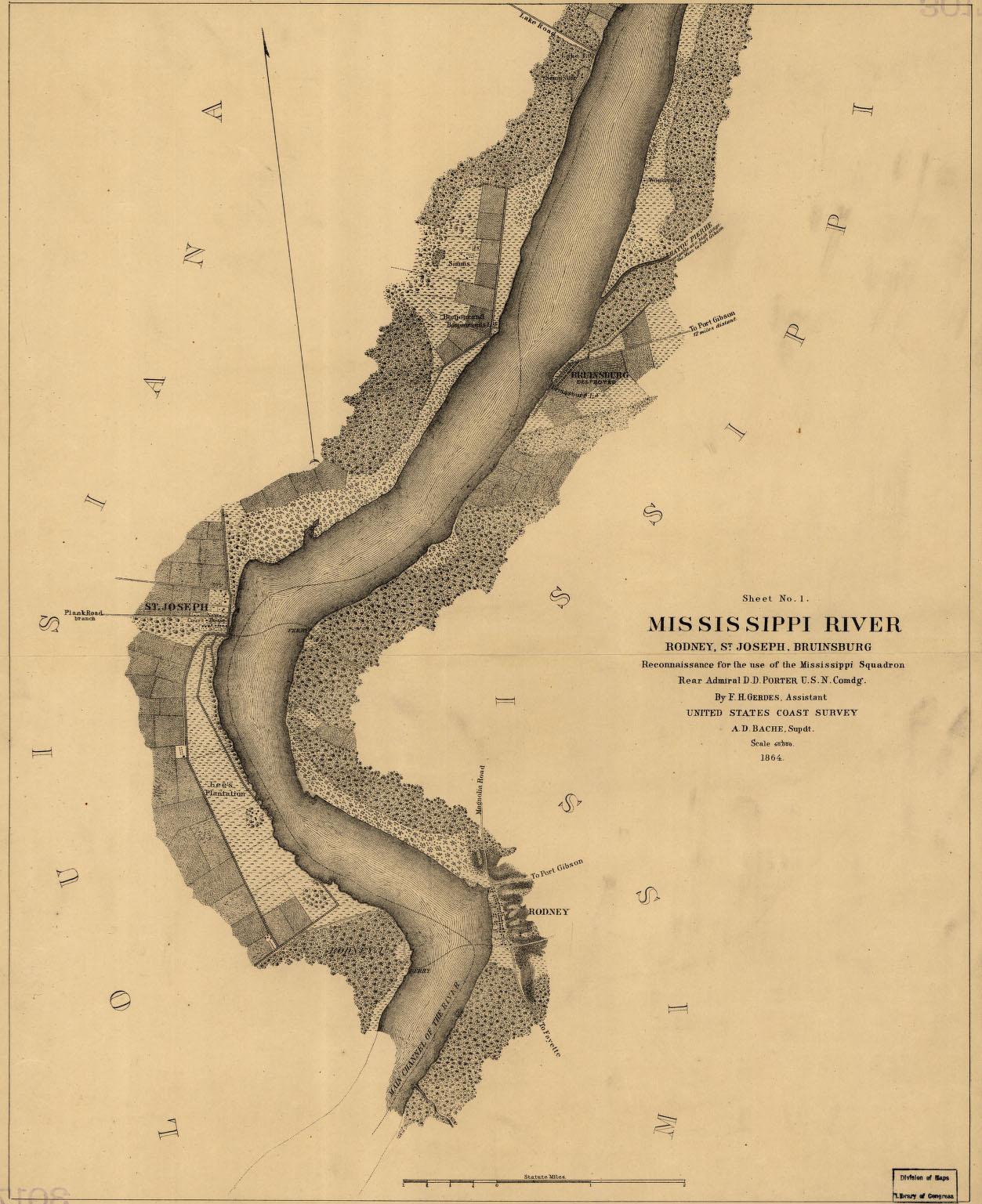 Bruinsburg, Rodney & St. Joseph areas 1864 — 287k. Map of general area where Grant crossed the Mississippi on his way to Vicksburg. Shows some landowners. From Library of Congress.
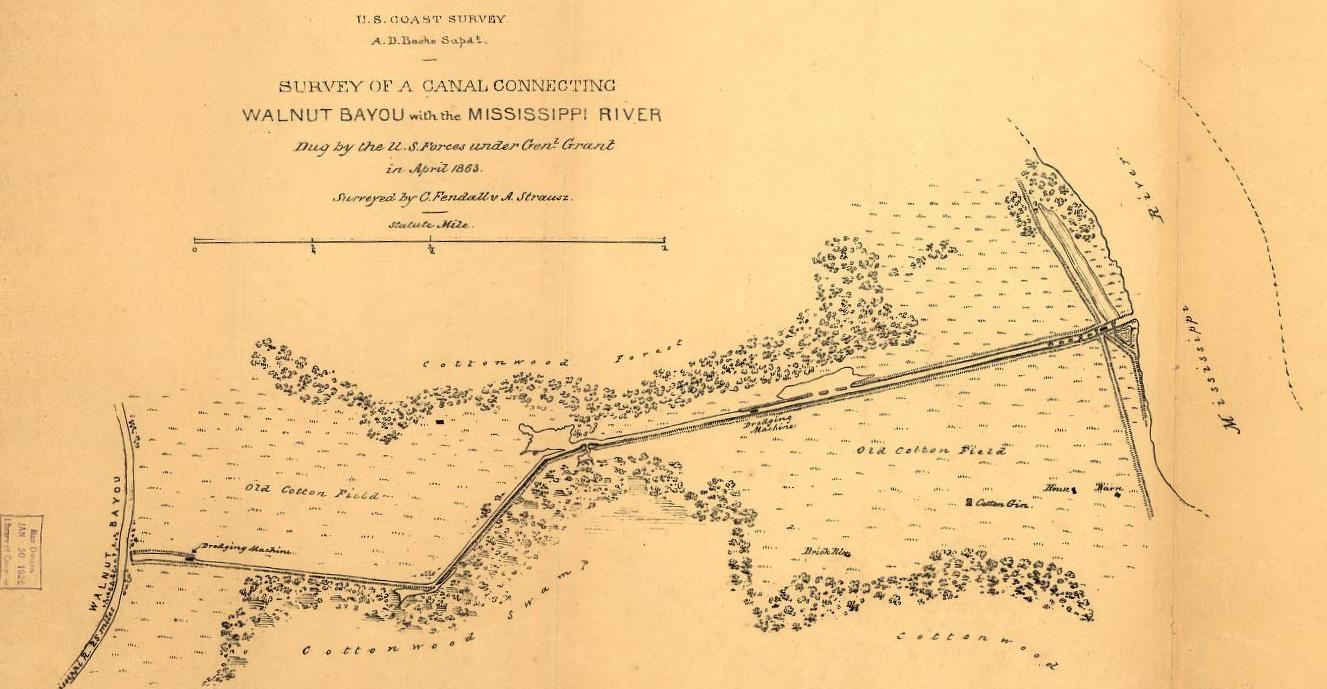 Duckport Canal 1863 — 127k. From Library of Congress. In Grant’s attempt to bypass Vicksburg, a 40’ wide by 7’ deep canal was dug from Duckport, LA on the Mississippi River westward to Walnut
Bayou. Several streams later, river traffic could theoretically reenter the Mississippi at New Carthage, LA – some 37 water miles downstream. This plan failed as did Grant’s other plans to divert the River. See also Civil War Canals in Madison Parish.
Duckport Canal 1863 — 127k. From Library of Congress. In Grant’s attempt to bypass Vicksburg, a 40’ wide by 7’ deep canal was dug from Duckport, LA on the Mississippi River westward to Walnut
Bayou. Several streams later, river traffic could theoretically reenter the Mississippi at New Carthage, LA – some 37 water miles downstream. This plan failed as did Grant’s other plans to divert the River. See also Civil War Canals in Madison Parish.
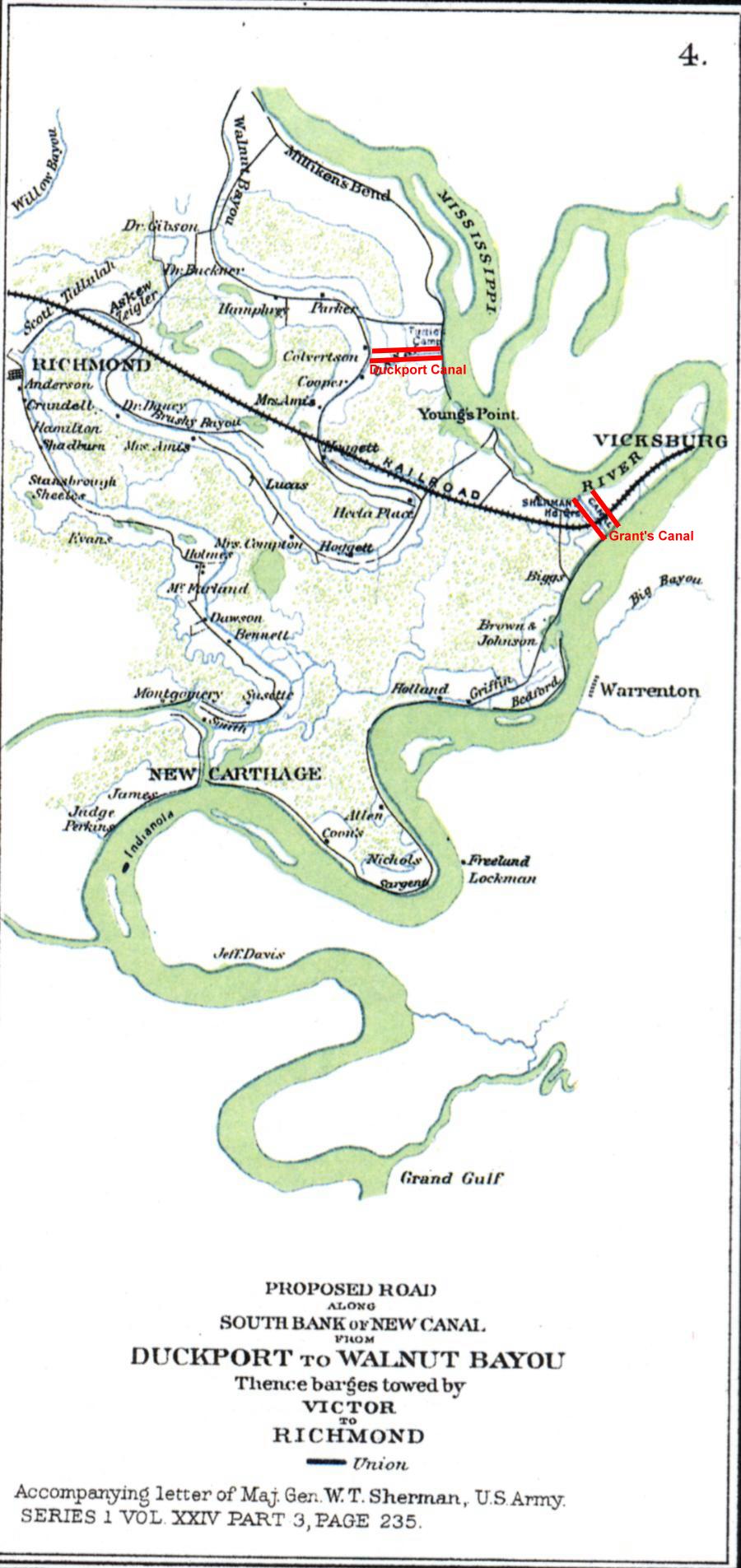 Duckport Canal Road 1863 — 175k. Shows area from Milliken’s Bend to New Carthage including some landowners and “Proposed Road along south bank of new canal from Duckport to Walnut Bayou thence barges towed by Victor to Richmond.” This is the canal mentioned above. From PLATE XXXV – map 4 of the Atlas to Accompany the Official Records of the Union and Confederate Armies 1861-1865. Courtesy of L. Graham Hughes.
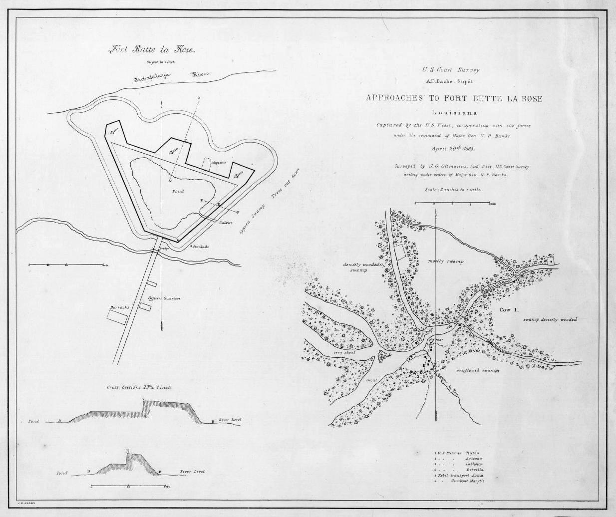 Fort Butte la Rose 1863 —151k. From Library of Congress
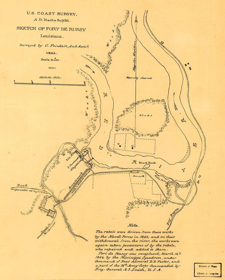 Fort DeRussy 1864 — 109k. Located on the Red River about 30 miles south of Alexandria, Fort DeRussy was captured in 1863, lost and later recaptured by Admiral David Porter on May 14th 1864. From Library of Congress
 Fort Jackson 1862 — 200k. Shows the effect of the bombardment by the U. S. Mortar Flotilla and Gunboats from April 18th to 24th, 1862. From Library of Congress
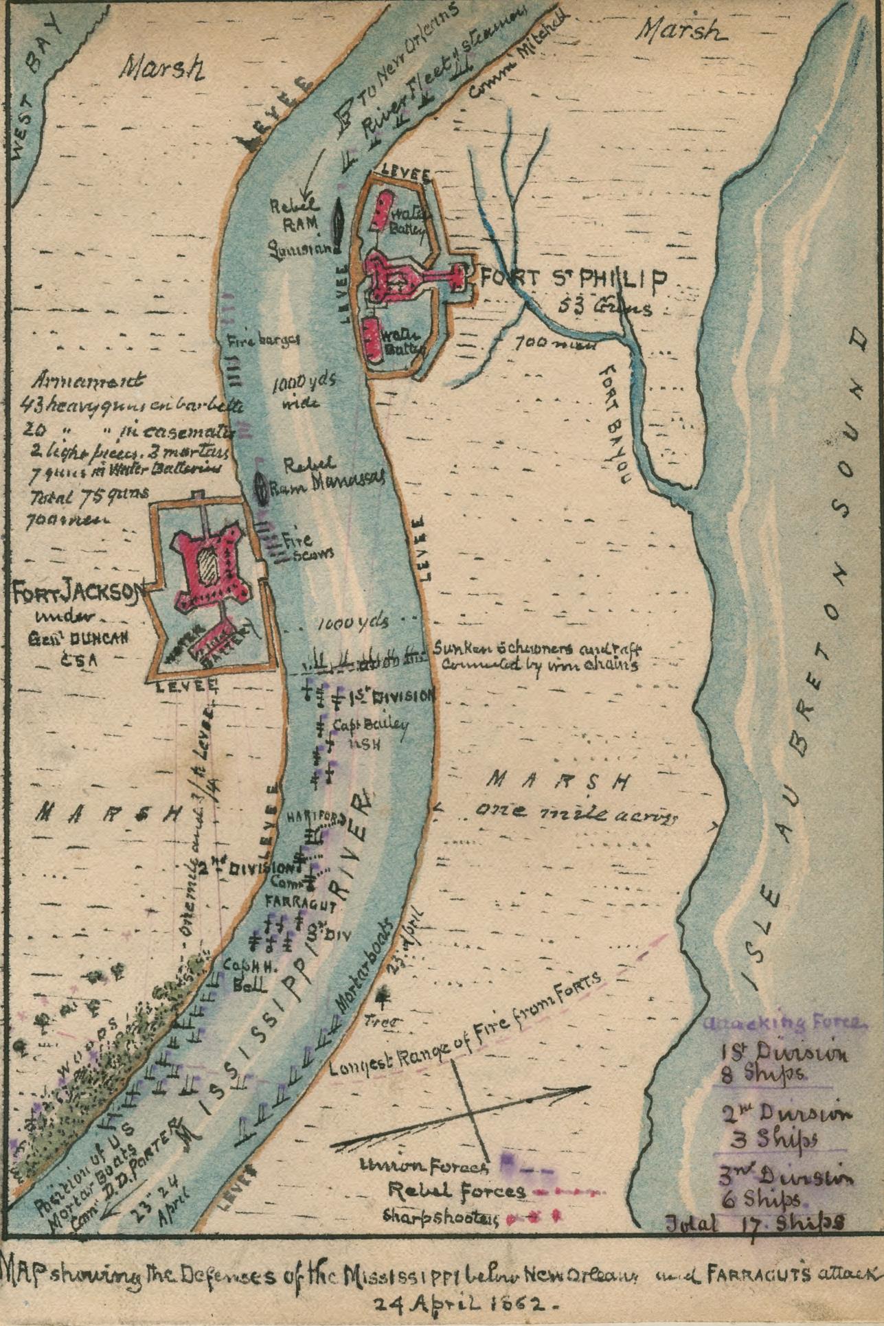 Forts Philip and Jackson 1862— 442k. This color-coded map shows the Confederate fortifications at Fort Jackson under Gen. Duncan, Fort St. Philip and the Union fleet along the Mississippi River below New Orleans. The map, also shows the positions of Union ships under Farragut, who captured the strategic port of New Orleans, thereby providing the Federal army access to the Mississippi River. From Library of Congress
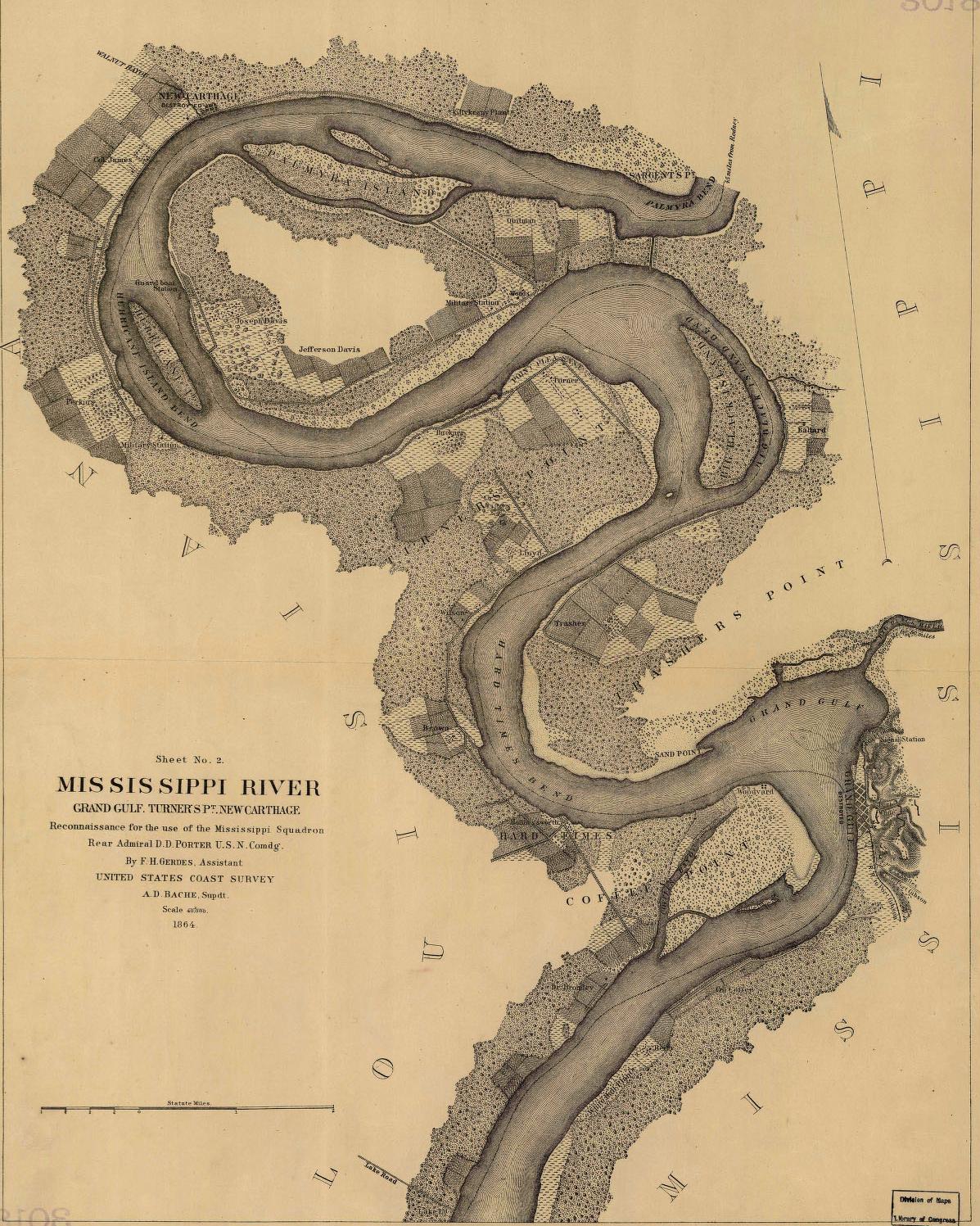 Grand Gulf, Turner’s Point & New Carthage areas — 425K. Fairly detailed map of general areas where Grant crossed the Mississippi on his way to Vicksburg. Shows some landowners including Joseph and Jefferson Davis. From Library of Congress.
 Grant's Canals — 90k. 1863 map from Harper's Weekly showing locations of canals dug under orders of General Grant in an effort to divert the Mississippi River around Vicksburg. Also shows location of Grant's march from Milliken's Bend to the south where he crossed the Mississippi near Grand Gulf; drove northeast to Jackson and ultimately west to defeat Vicksburg after a prolonged siege.
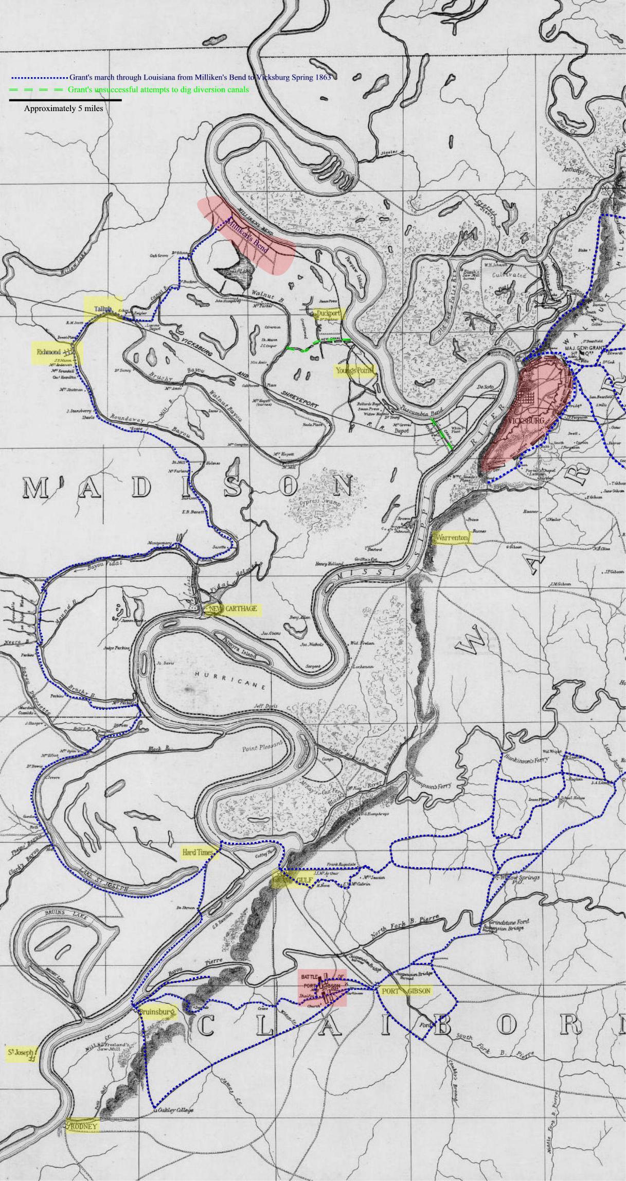 Grant’s March — 548k. Grant’s March through northeast Louisiana from Milliken’s Bend to Vicksburg – Spring 1863. From Library of Congress
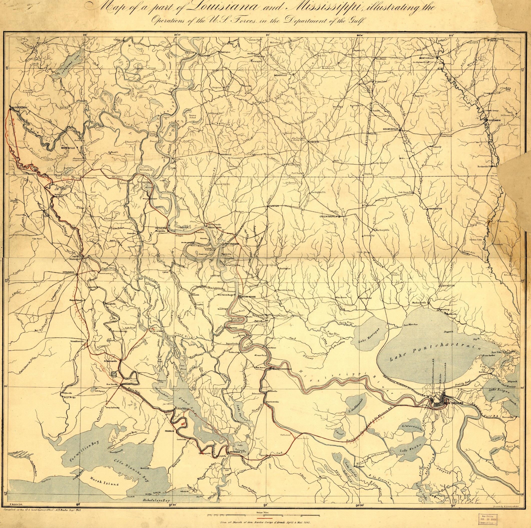 Louisiana-Mississippi Military Map 1863 —1,565k. Map of a part of Louisiana and Mississippi, illustrating the operations of the U.S. forces, in the Department of the Gulf Drawn by H. Lindenkohl. E. Moliter lith. Covers area from Alexandria on the northwest to New Orleans on the southeast. From Library of Congress
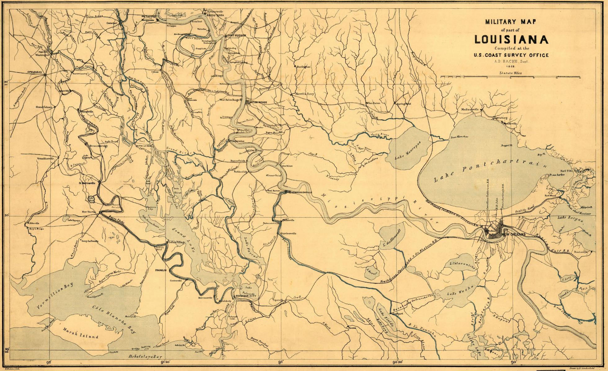 Military Map of Southeastern Louisiana-1863 — 516k. From Library of Congress
 Northwest Louisiana — 174k. Shows Red River from Arkansas line to Natchitoches. From PLATE LII – map 1 of the Atlas to Accompany the Official Records of the Union and Confederate Armies 1861-1865. Courtesy of L. Graham Hughes.
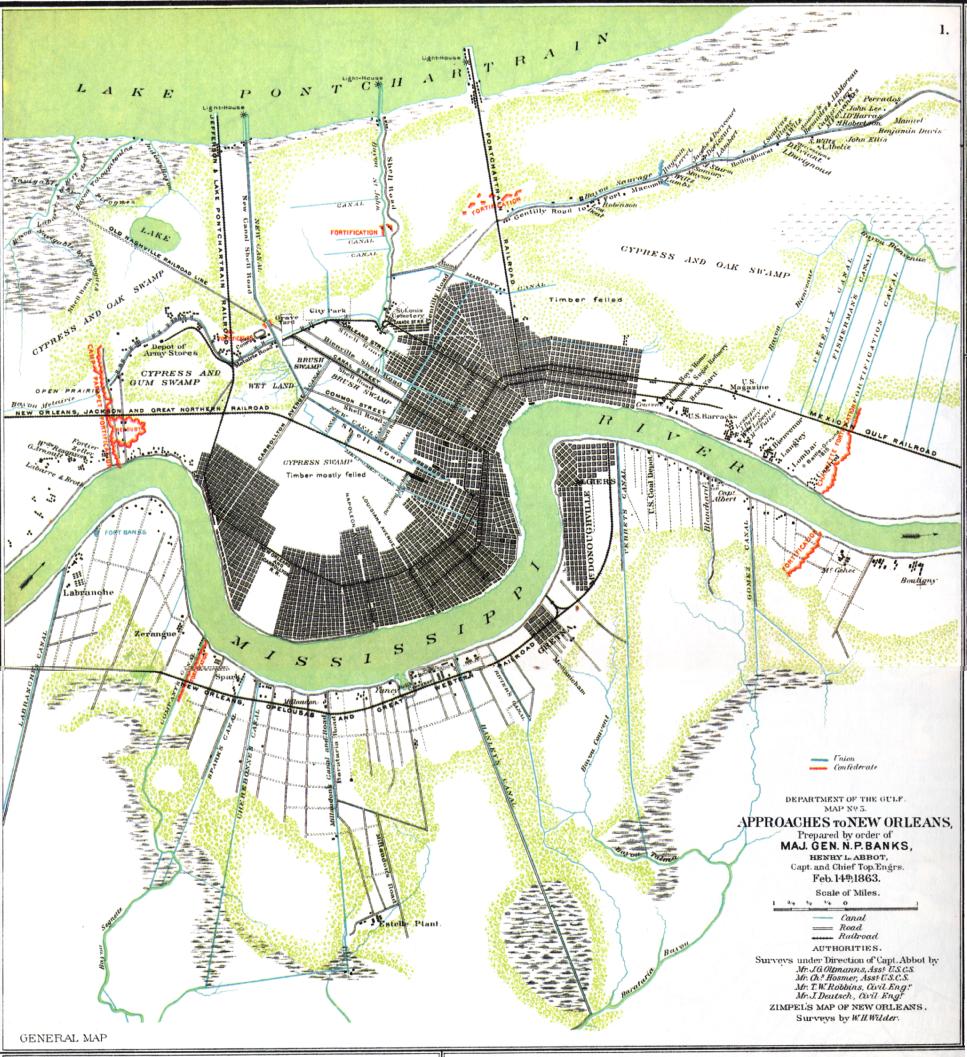 New Orleans 1863 — 213k. Map of the “Approaches to New Orleans.” Shows Confederate fortifications. From PLATE XCI – map 1 of the Atlas to Accompany the Official Records of the Union and Confederate Armies 1861-1865. Courtesy of L. Graham Hughes.
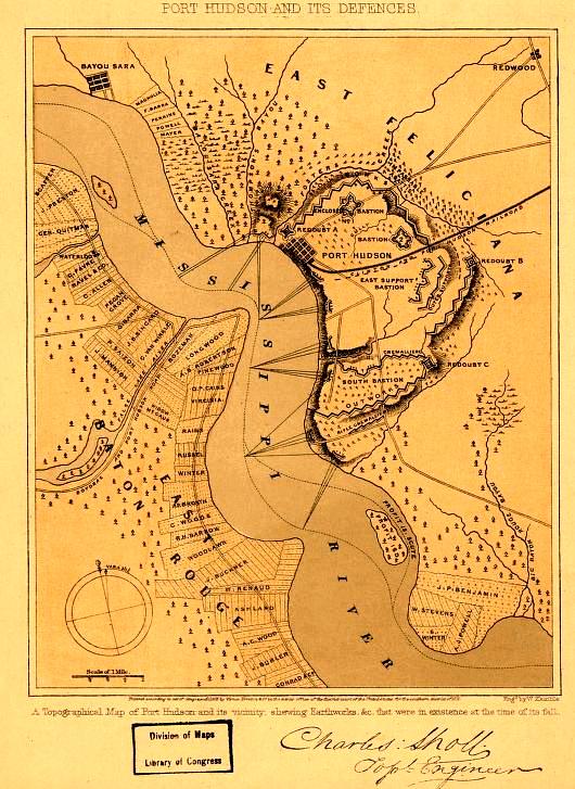 Port Hudson-1862 — 112k. Shows defenses existing at the time of the Battle of Port Hudson. From Library of
Congress
Port Hudson-1862 — 112k. Shows defenses existing at the time of the Battle of Port Hudson. From Library of
Congress
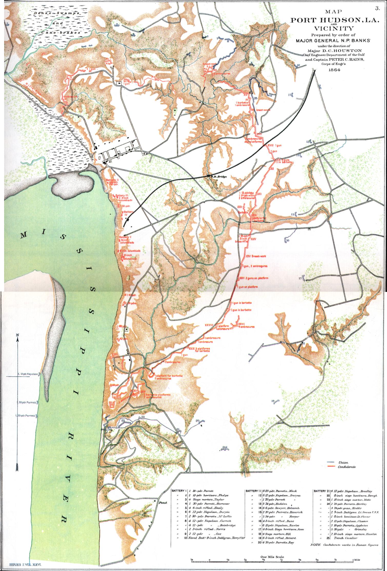 Port Hudson — 567k. Detailed map of Confederate and Union positions. Dated 1864 (?). From PLATE XXXVIII – map 3 of the Atlas to Accompany the Official Records of the Union and Confederate Armies 1861-1865. Courtesy of L. Graham Hughes.
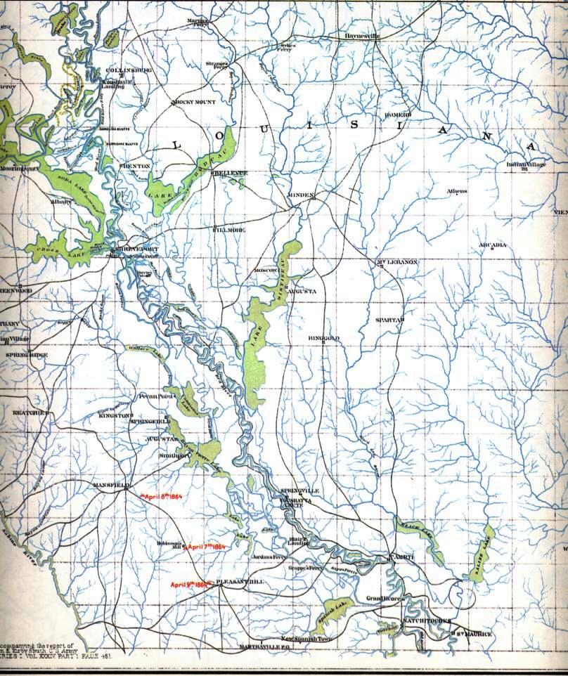
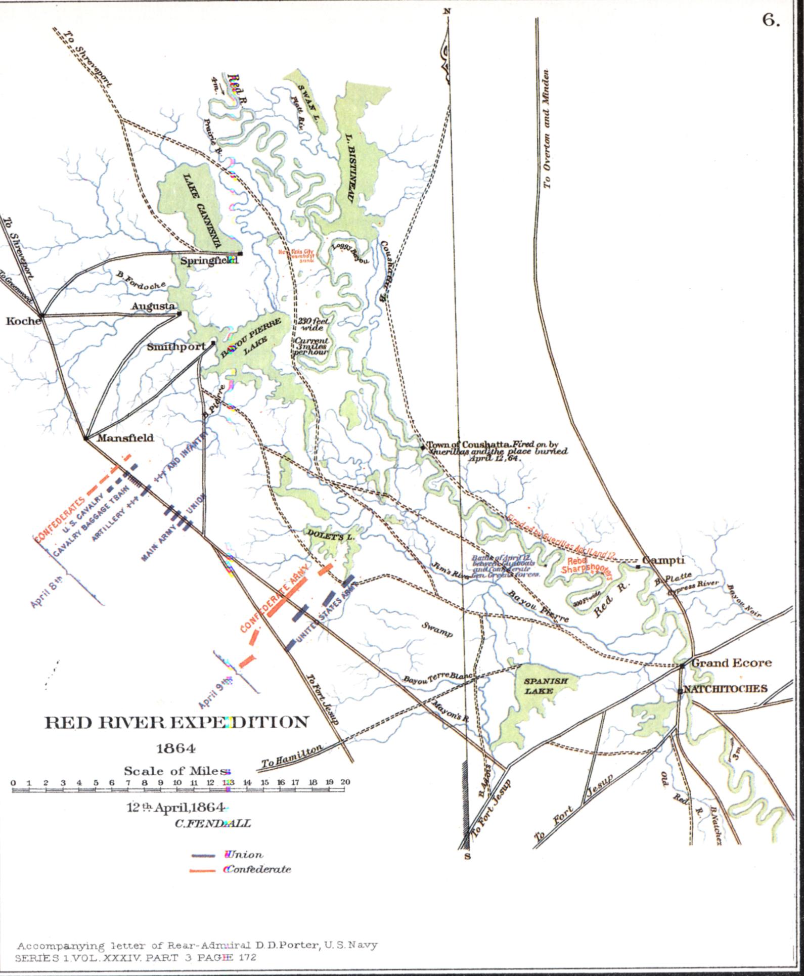 Red River Expedition 1864 — 260k. Shows area from Lake Bistineau to Natchitoches with Confederate and Union defense positions. From PLATE L – map 6 of the Atlas to Accompany the Official Records of the Union and Confederate Armies 1861-1865. Courtesy of L. Graham
Hughes.
Red River Expedition 1864 — 260k. Shows area from Lake Bistineau to Natchitoches with Confederate and Union defense positions. From PLATE L – map 6 of the Atlas to Accompany the Official Records of the Union and Confederate Armies 1861-1865. Courtesy of L. Graham
Hughes.

Sabine Pass 1863 — 150k. Shows Confederate defense positions and “means of communication.” From PLATE XXXII – map 3 of the Atlas to Accompany the Official Records of the Union and Confederate Armies 1861-1865. Courtesy of L. Graham Hughes.
 Vicksburg and its “Defences” 1863 — 204K. Shows all batteries in force at the time of surrender; also plantation names, especially in Madison Parish, LA. From Library of Congress.
Note: Many more maps showing parts of Louisiana in the Civil War can be found in the Mississippi Digital Map Library.
![]()
USGS Topographic maps for Louisiana are available by clicking here, selecting a “Cell Name”, then right-clicking the corresponding “TIFF” image and selecting “Save Target as...” Save and rename file to any location desired. The map file will then be downloaded to the selected location where it can be viewed and manipulated with almost any imaging program. Note that these TIFF files are very large, from 2 to 10 megabytes, but can be made smaller by resizing after the download.
The two maps below show the geographic distribution of those who viewed the Louisiana Digital Map Library during the months of July 2013 through June 2014. In one year there has been a total of 12,224 viewers from 2,175 different cities - 1,890 in the United States and 285 foreign. Fifty-nine different countries were represented.
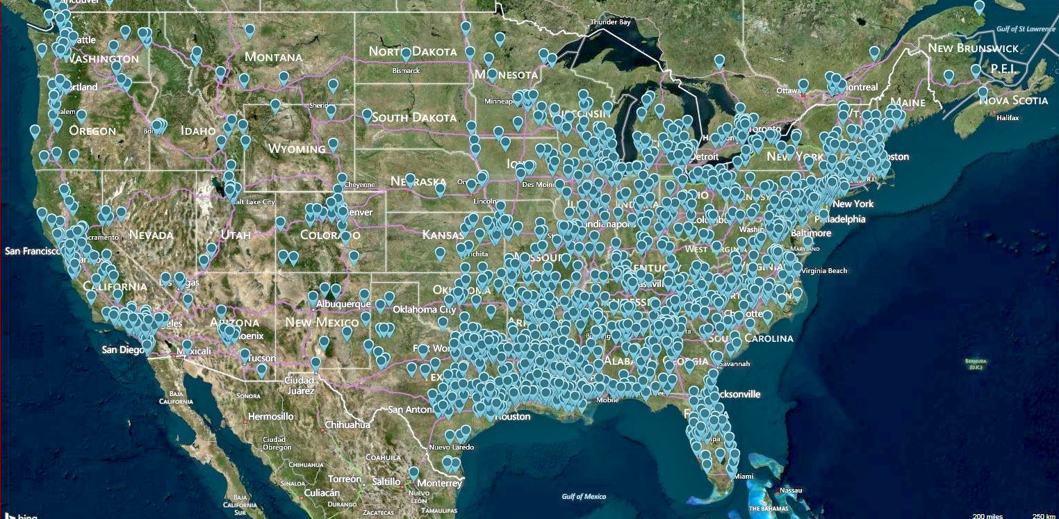
United States and Canadian Viewers July 2013 through June 2014 (Map
made using Mapcite)
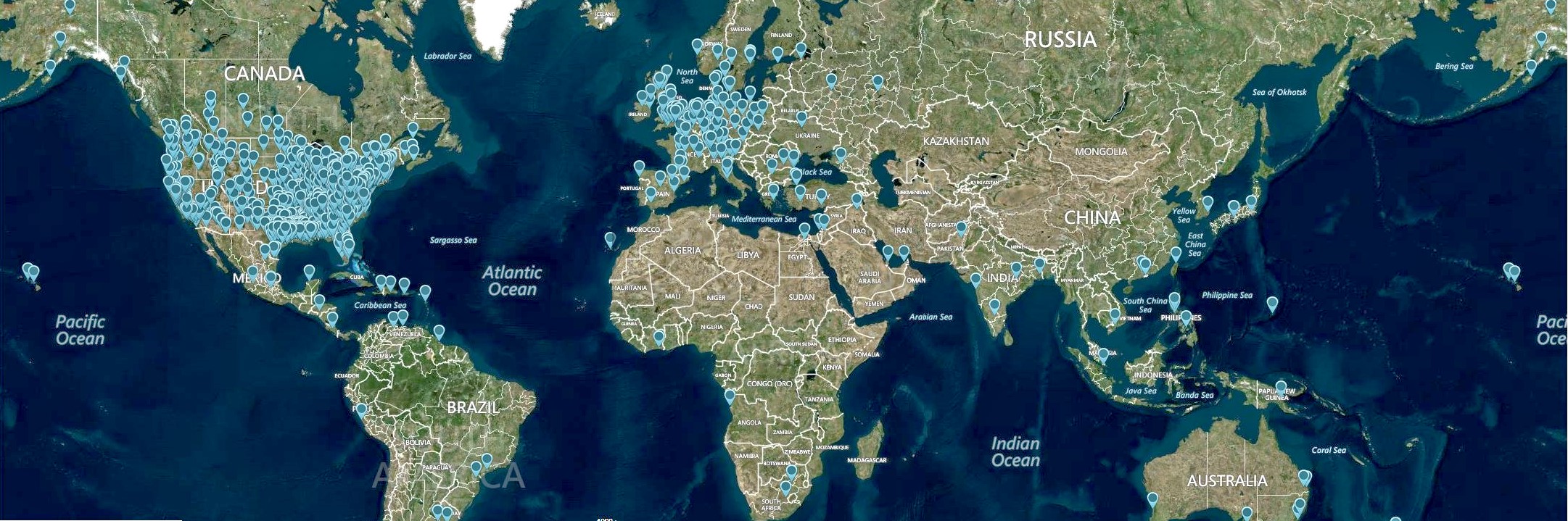
World Viewers July 2013 through June 2014
(Map made using Mapcite)
![]()
E-mail Richard P. Sevier, Coordinator at: dicksevier@gmail.com
![]()


This page was first posted on: 04 June 1999
![]()
Copyright © 1999-2014 Richard P. Sevier dicksevier@gmail.com