


The Mississippi Digital Map Library
State Map Coordinator: Richard P. Sevier dicksevier@gmail.com
This page was last updated
7/22/2019
Note that each map may be enlarged by clicking on it or its title. Most can be further enlarged by placing the cursor on the image and then clicking on the button in the lower right hand corner.
State Maps
County Maps
City Maps
Civil War Maps
Topographic Maps
Website
Statistics
![]()
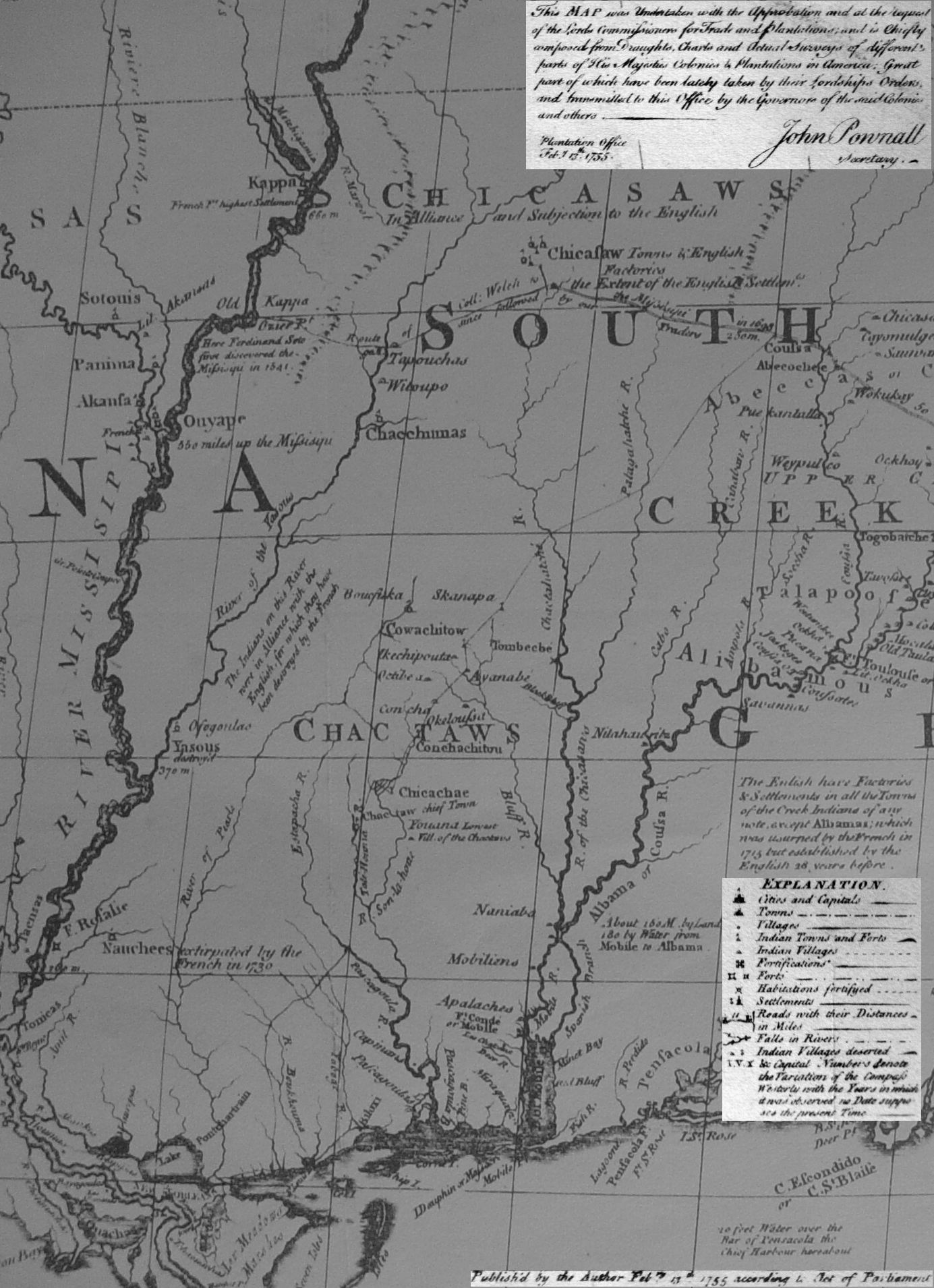 Mississippi 1755 — 392K.
Part of a larger map, known as the John Mitchell map, covering the approximate east 60% of what is now the United States. The map was made “with the approbations and at the request of the Lords Commissioners for Trade and plantations and is chiefly composed from ... parts of His Majesty’s Colonies and Plantations in America.” This Mississippi portion primarily shows principal streams and Indian tribal areas.
Courtesy of F. Dean Williams.
Mississippi 1755 — 392K.
Part of a larger map, known as the John Mitchell map, covering the approximate east 60% of what is now the United States. The map was made “with the approbations and at the request of the Lords Commissioners for Trade and plantations and is chiefly composed from ... parts of His Majesty’s Colonies and Plantations in America.” This Mississippi portion primarily shows principal streams and Indian tribal areas.
Courtesy of F. Dean Williams.
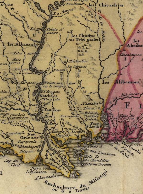 Mississippi 1756 — 116K.
French map in color showing portions of what is now Mississippi and surrounding states. From Library of Congress.
Mississippi 1756 — 116K.
French map in color showing portions of what is now Mississippi and surrounding states. From Library of Congress.
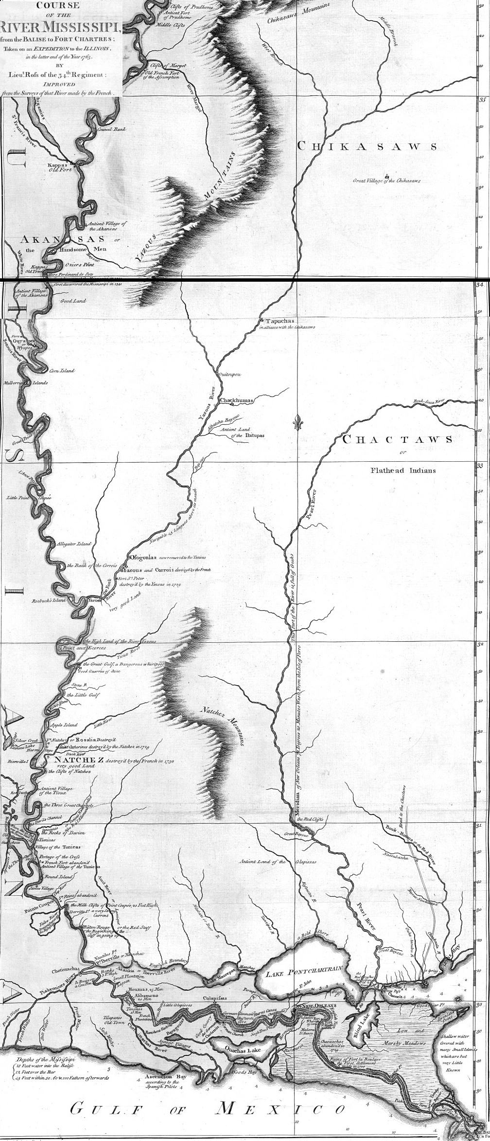
Mississippi 1765
— 743K.
Mississippi portion of "Course of the Mississippi from Balise to Ft. Chartres Taken on an Expedition to the Illinois in the latter end of the Year of 1765 from the Surveys of river made by the French.
From Library of Congress.
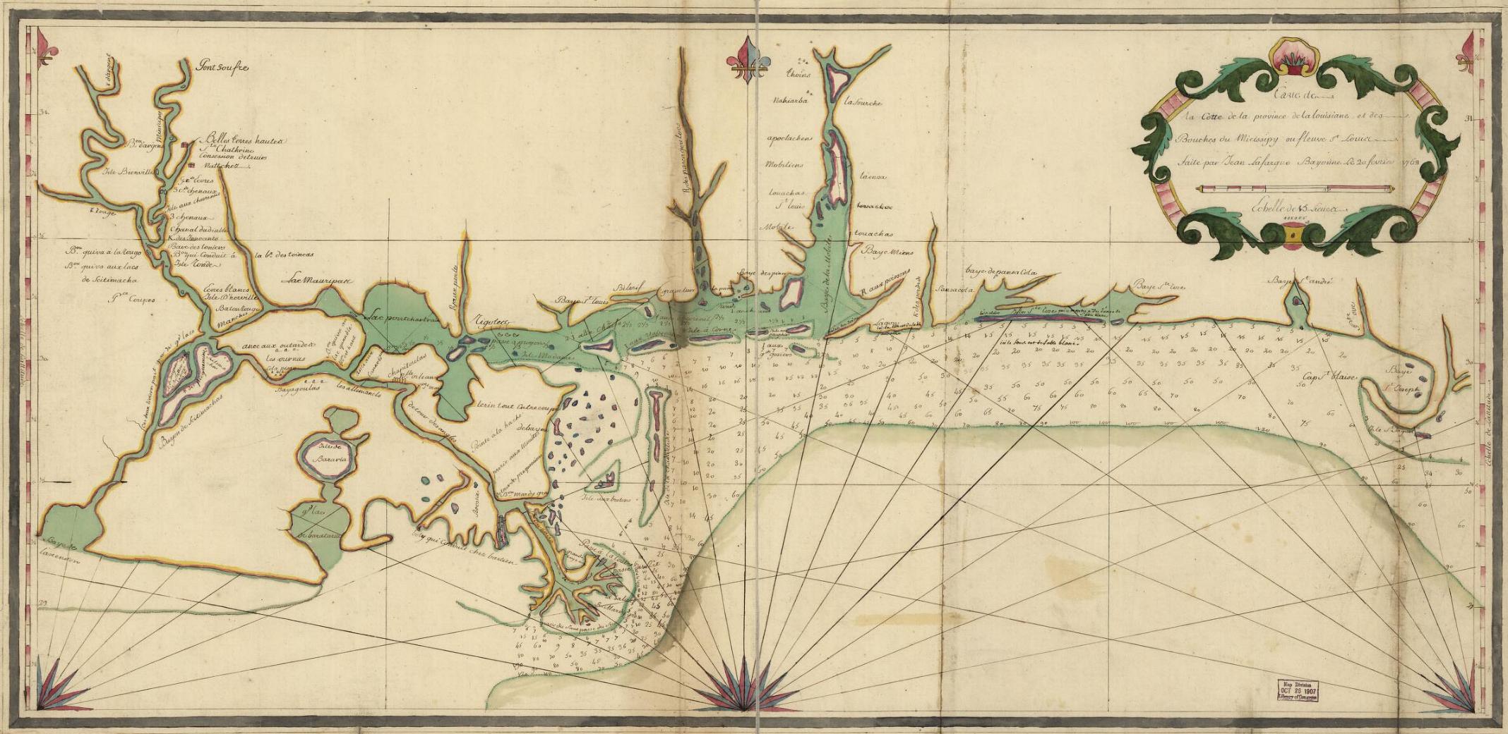 Louisiana-Mississippi Coast 1768
— 338K.
In French. Shows mouth of “Micissipy” and related streams. From Library of Congress.
Louisiana-Mississippi Coast 1768
— 338K.
In French. Shows mouth of “Micissipy” and related streams. From Library of Congress.
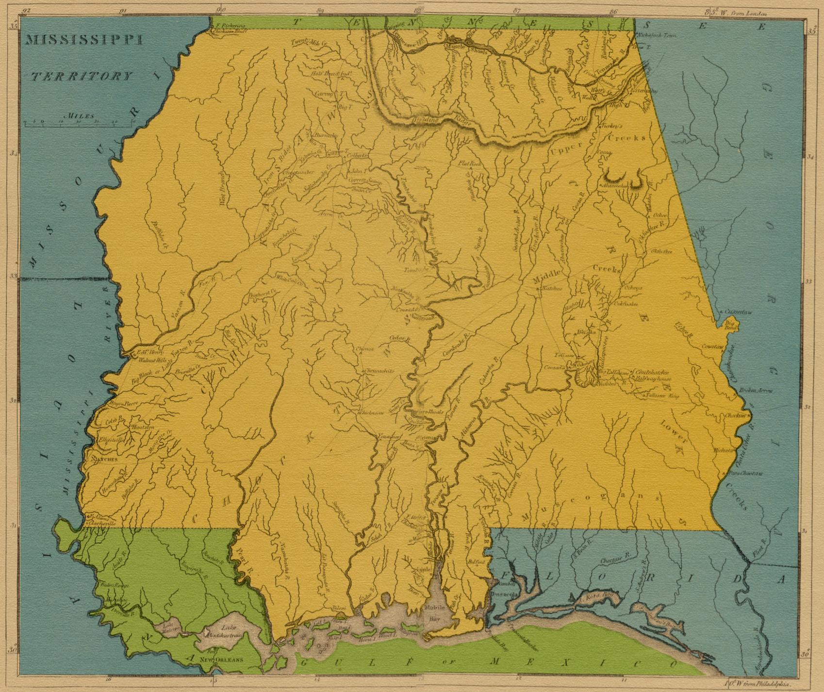
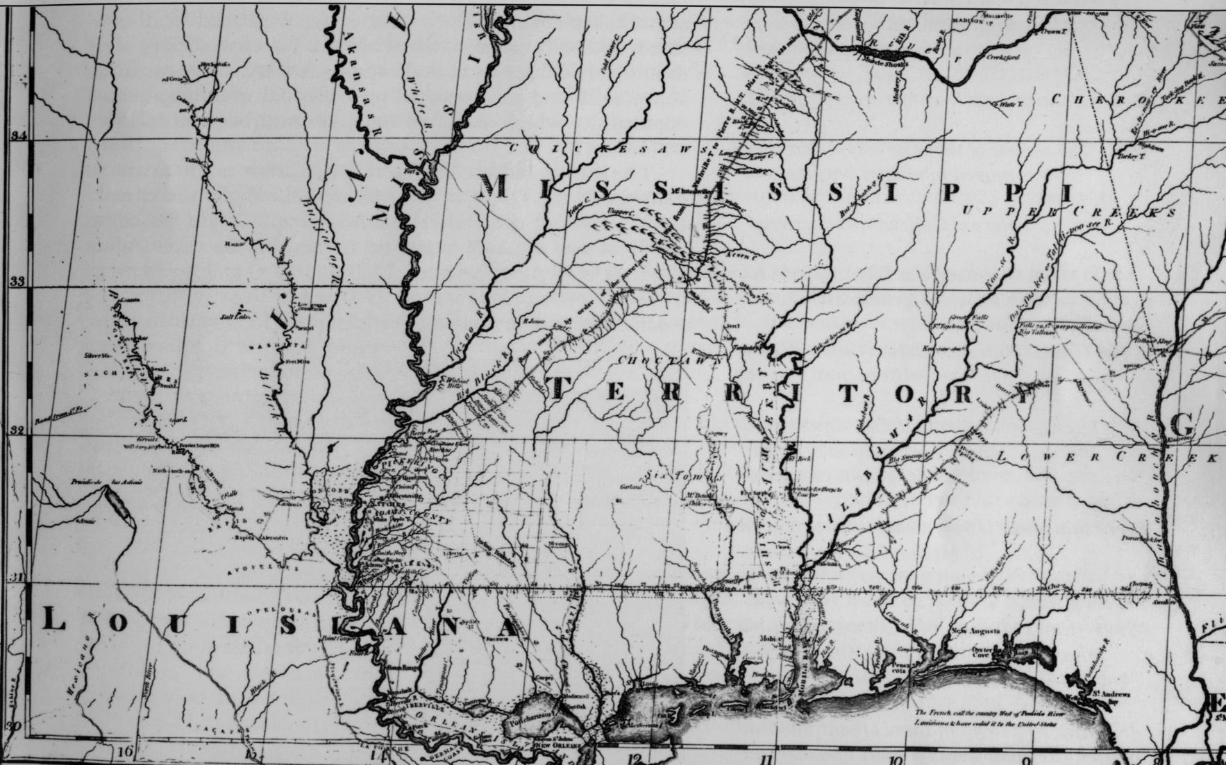
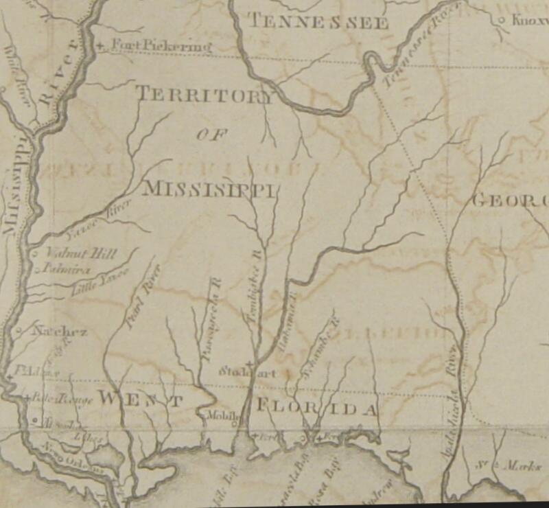
 Mississippi Territory 1801 — 306K.
Pre-statehood
map of Mississippi Territory. Shows portions of Mississippi, Louisiana, Alabama and Arkansas.
From Library of Congress.
Mississippi Territory 1801 — 306K.
Pre-statehood
map of Mississippi Territory. Shows portions of Mississippi, Louisiana, Alabama and Arkansas.
From Library of Congress.
 Mississippi Territory 1810
— 342K.
Pre-statehood map of
Mississippi Territory, drawn by Christian Schultz, Jr. and published by I. Riley, New York.
Courtesy of F. Dean Williams
Mississippi Territory 1810
— 342K.
Pre-statehood map of
Mississippi Territory, drawn by Christian Schultz, Jr. and published by I. Riley, New York.
Courtesy of F. Dean Williams
 Mississippi Territory
1816
— 411K.
Pre-statehood
map of Mississippi Territory, which included
the present states of Mississippi and Alabama.
Mississippi Territory
1816
— 411K.
Pre-statehood
map of Mississippi Territory, which included
the present states of Mississippi and Alabama.
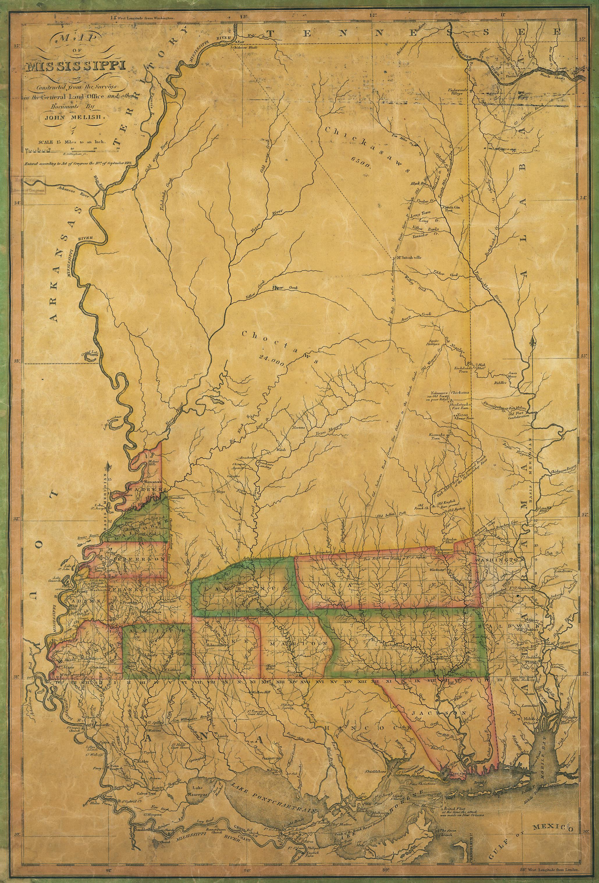 Mississippi 1820
— 1,215K.
"Map of Mississippi Constructed from the Surveys in the General Land Office and other Documents by John Melish.
From Library of Congress.
Mississippi 1820
— 1,215K.
"Map of Mississippi Constructed from the Surveys in the General Land Office and other Documents by John Melish.
From Library of Congress.
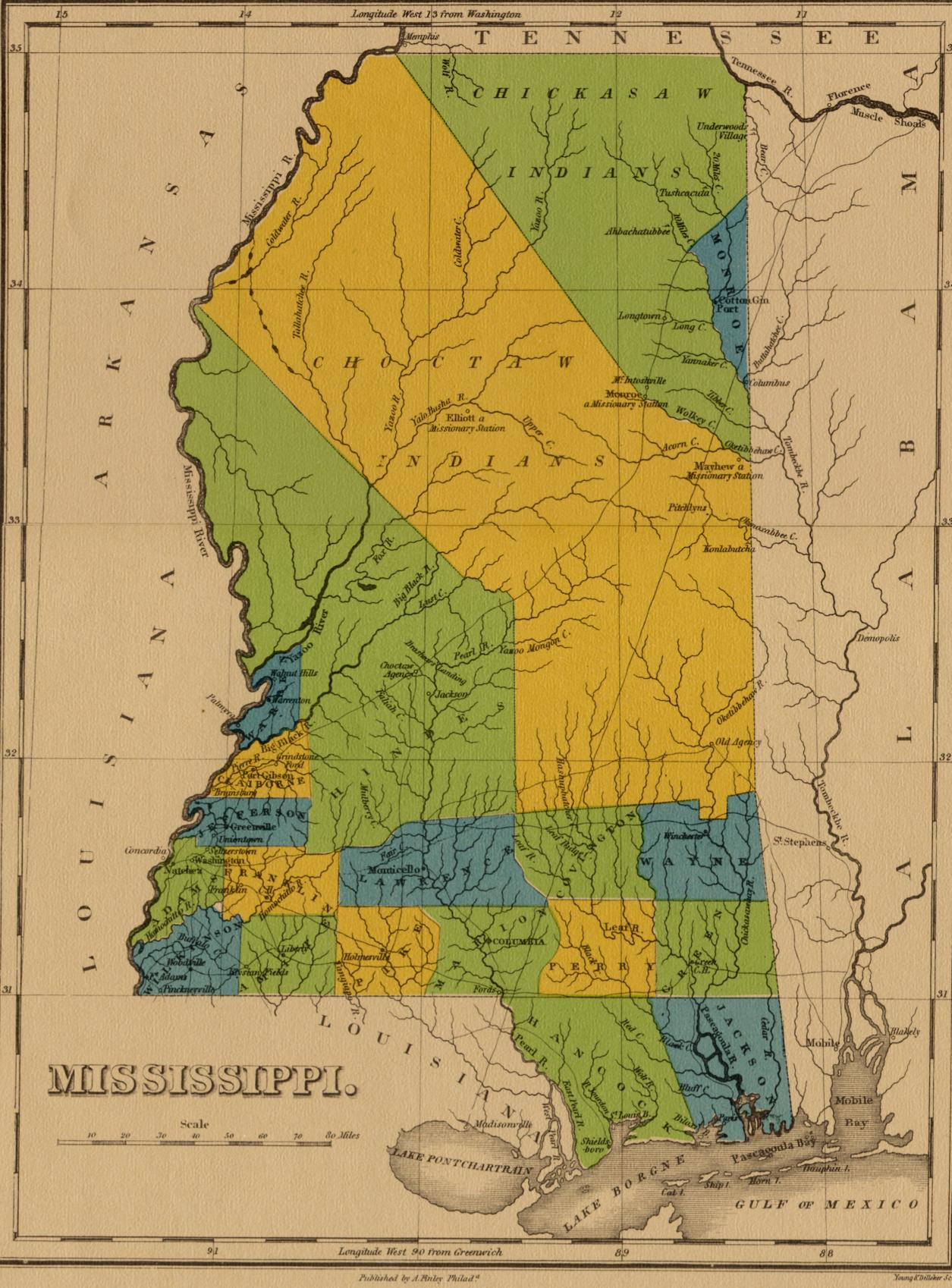 Mississippi 1822
— 355K.
Circa 1822 Showing existent towns, counties and Chickasaw & Choctaw Indian lands. Published by A. Finley, Philadelphia.
Mississippi 1822
— 355K.
Circa 1822 Showing existent towns, counties and Chickasaw & Choctaw Indian lands. Published by A. Finley, Philadelphia.
 Mississippi c1828
— 420K.
Shows towns, counties and Indian Lands, as they appeared about 1828. Publisher unknown. See Louisiana Index for same map of that state. Courtesy of Charles Brenner, Eudora Welty Library, Jackson, MS.
Mississippi c1828
— 420K.
Shows towns, counties and Indian Lands, as they appeared about 1828. Publisher unknown. See Louisiana Index for same map of that state. Courtesy of Charles Brenner, Eudora Welty Library, Jackson, MS.
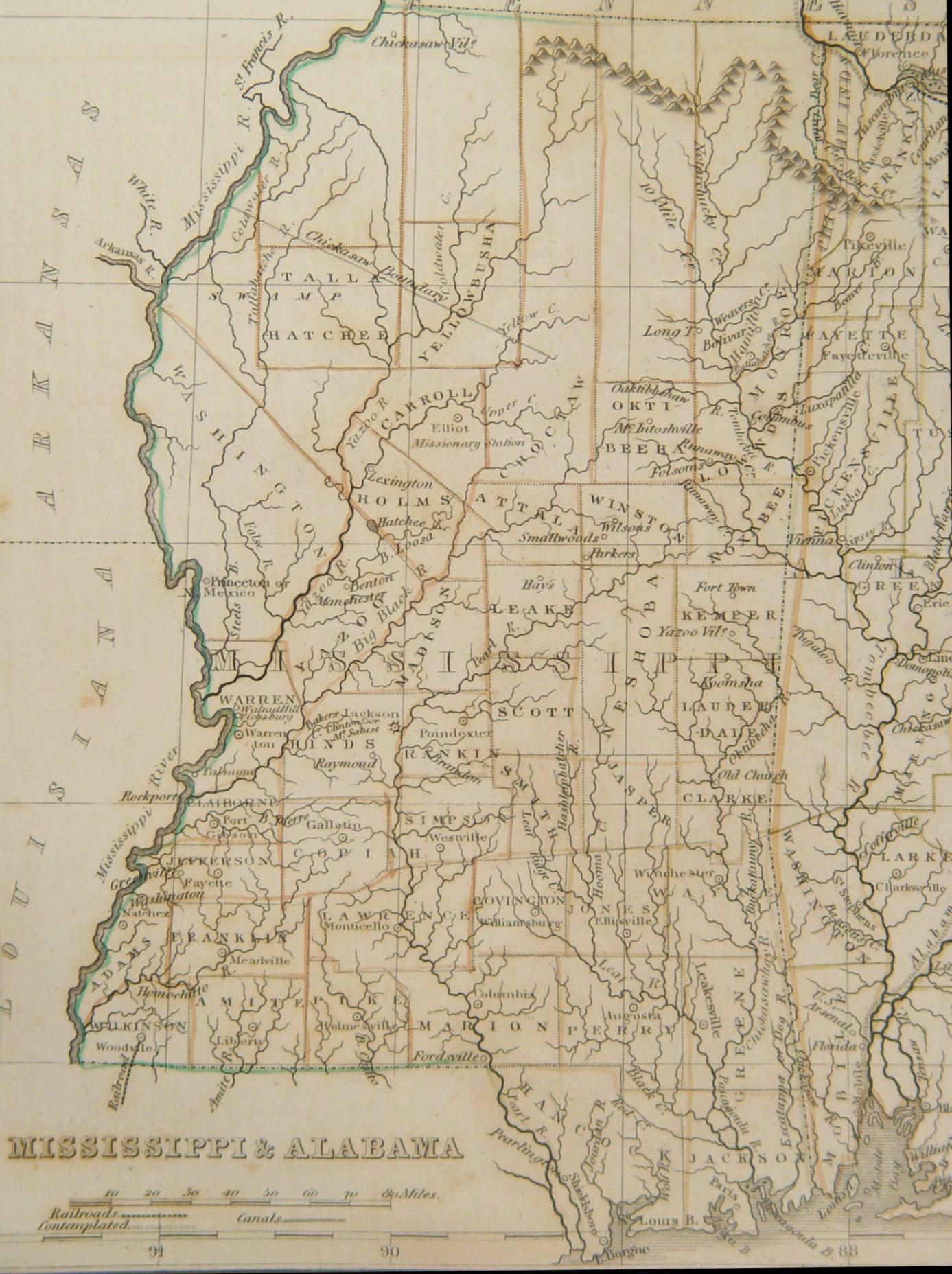
 Mississippi 1835
— 344K.
Map by Bradford, showing county configuration with towns. Courtesy of
F. Dean Williams
Mississippi 1835
— 344K.
Map by Bradford, showing county configuration with towns. Courtesy of
F. Dean Williams
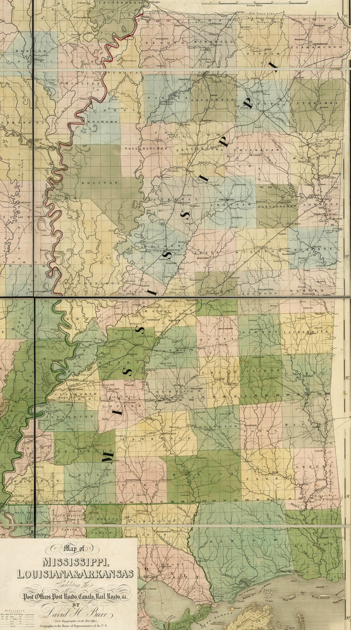
Mississippi 1839
— 1,594K.
Detailed map of Mississippi exhibiting the post offices, post roads, canals, rail roads, &c. by David H. Burr (late topographer to the Post Office), Geographer to the House of Representatives of the U.S. From Burr's The American Atlas (London, J. Arrowsmith, 1839)
From Library of Congress.
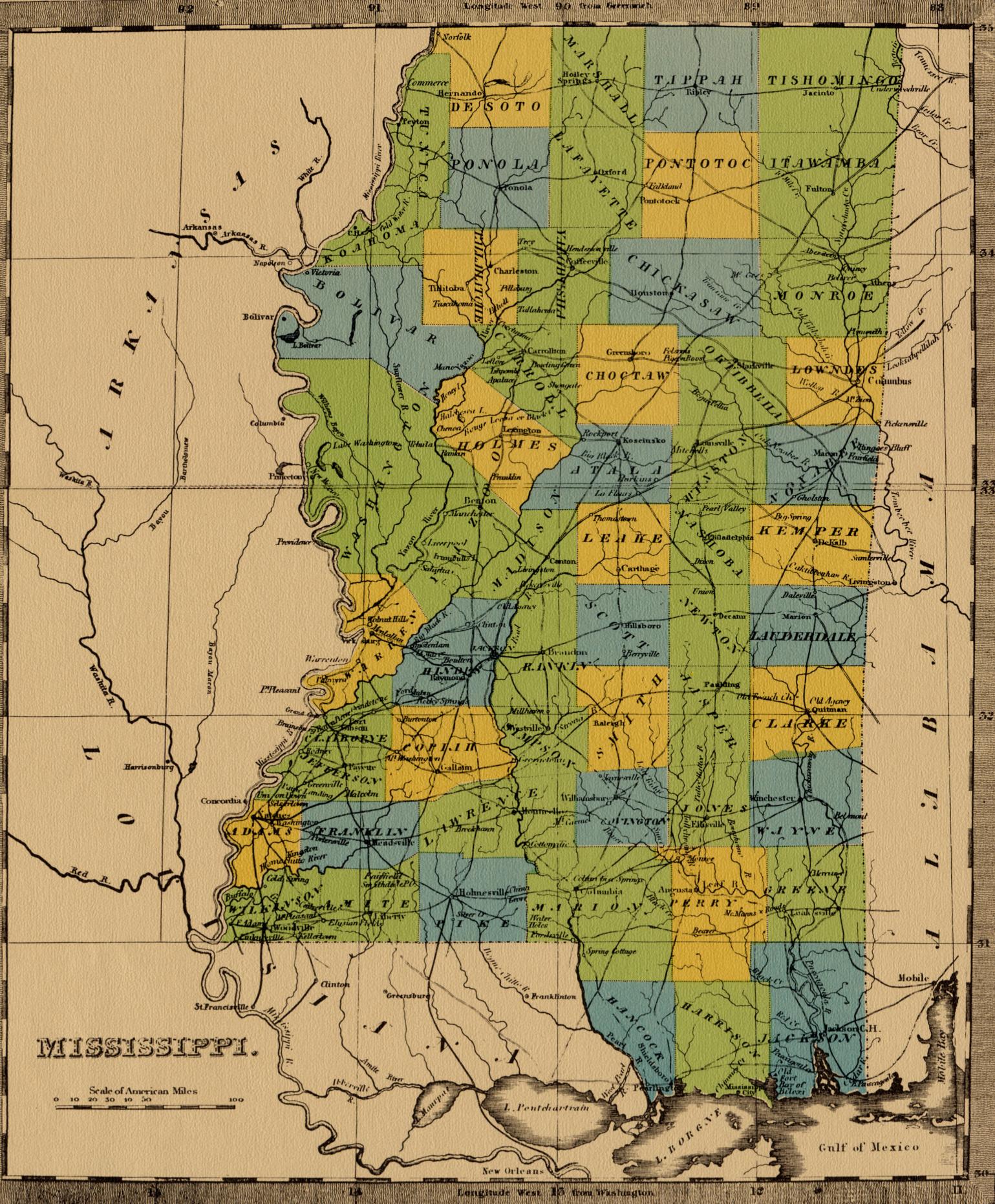 Mississippi 1842
— 619K.
Circa 1842 showing county configuration with towns and roads.
Mississippi 1842
— 619K.
Circa 1842 showing county configuration with towns and roads.
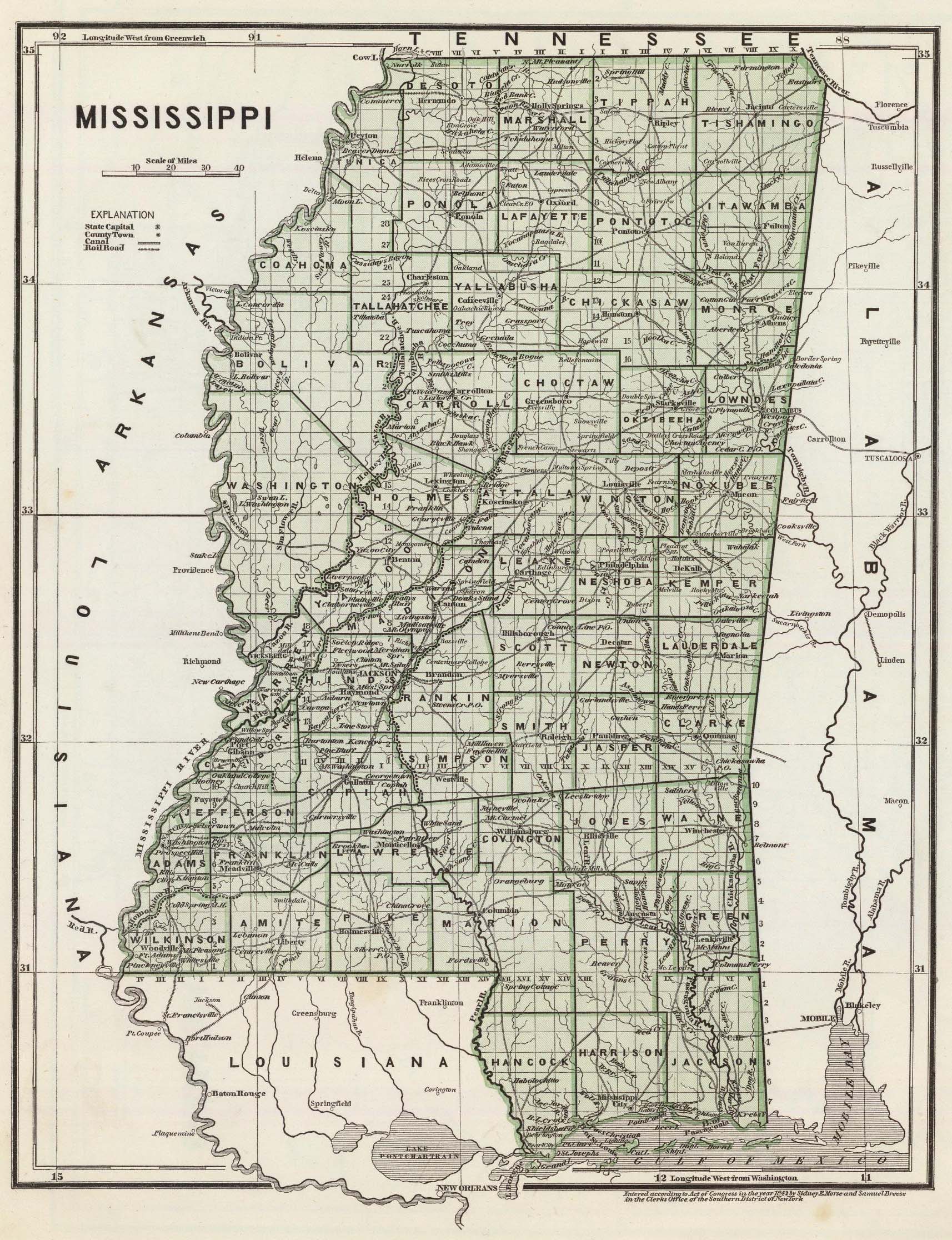 Mississippi 1845
— 777K.
Circa 1845 showing county configuration with towns, roads and railroads, but with many more towns and villages than the 1842 map above. Originally part of Morse’s North American Atlas, Published by Harper & Brothers. From Library of Congress.
Mississippi 1845
— 777K.
Circa 1845 showing county configuration with towns, roads and railroads, but with many more towns and villages than the 1842 map above. Originally part of Morse’s North American Atlas, Published by Harper & Brothers. From Library of Congress.
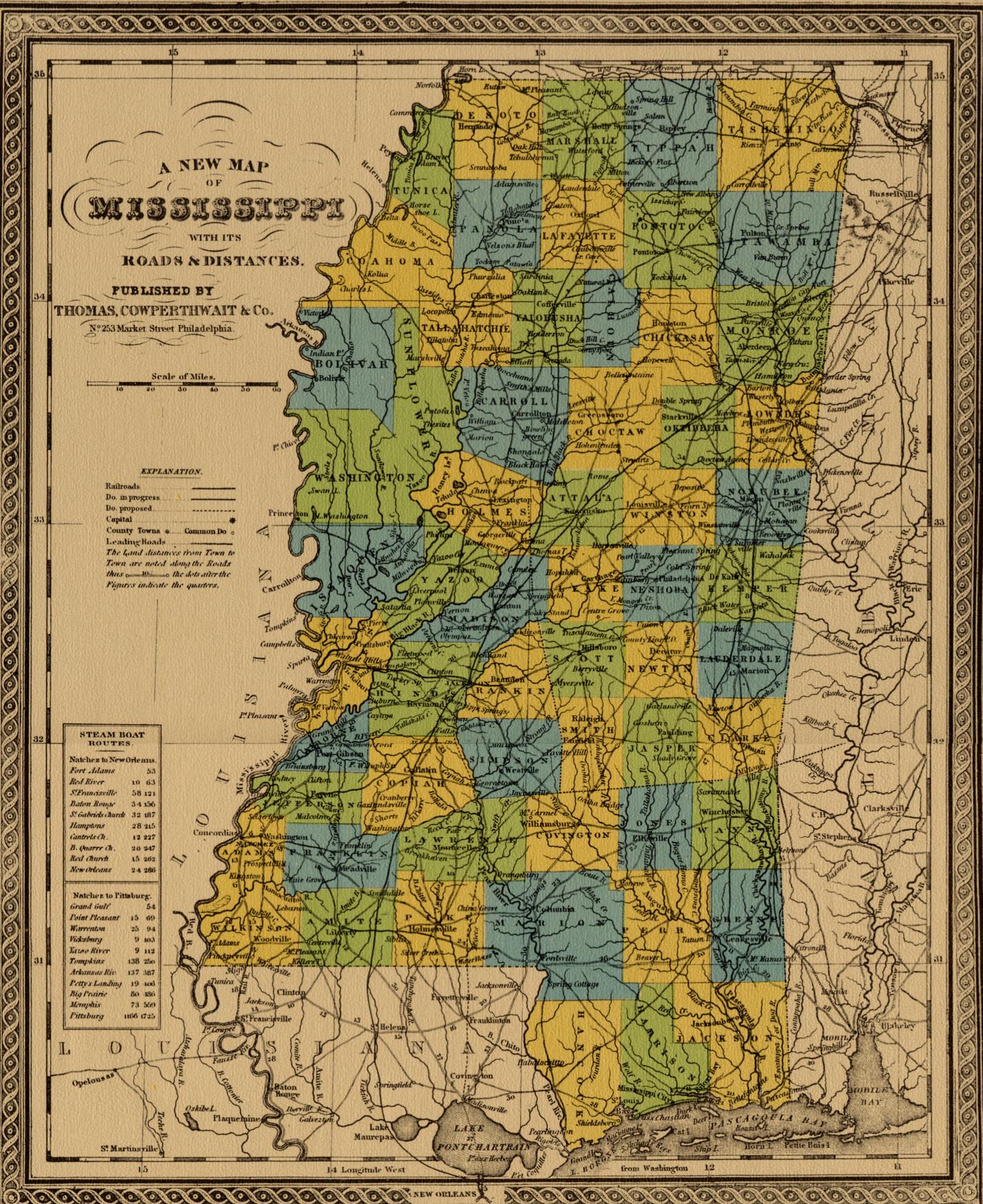
 Mississippi 1852
— 627K.
Circa 1852 showing towns, counties, roads and distances, including steamboat distances. Published by Thomas, Cowperthwait & Co., Philadelphia.
Mississippi 1852
— 627K.
Circa 1852 showing towns, counties, roads and distances, including steamboat distances. Published by Thomas, Cowperthwait & Co., Philadelphia.
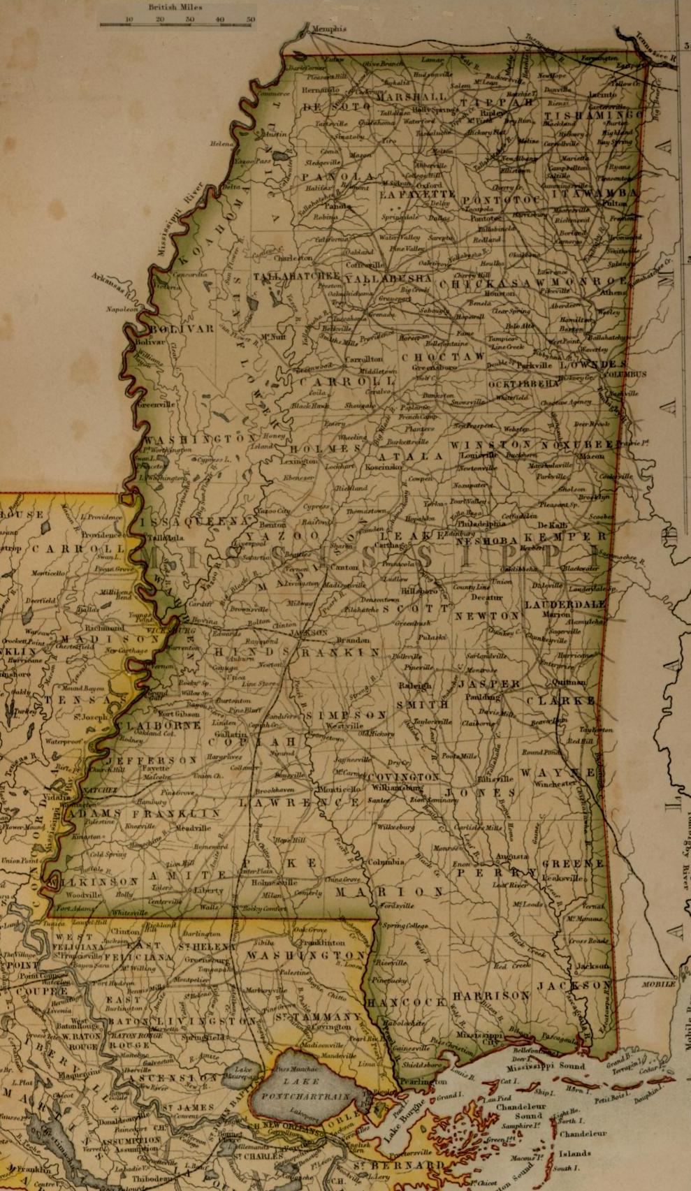
 Mississippi 1855
— 321K.
A & C Black published this interesting map in Edinburgh, Scotland, probably about 1855. The scale is in "British" miles.
Mississippi 1855
— 321K.
A & C Black published this interesting map in Edinburgh, Scotland, probably about 1855. The scale is in "British" miles.
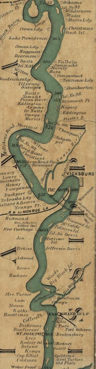
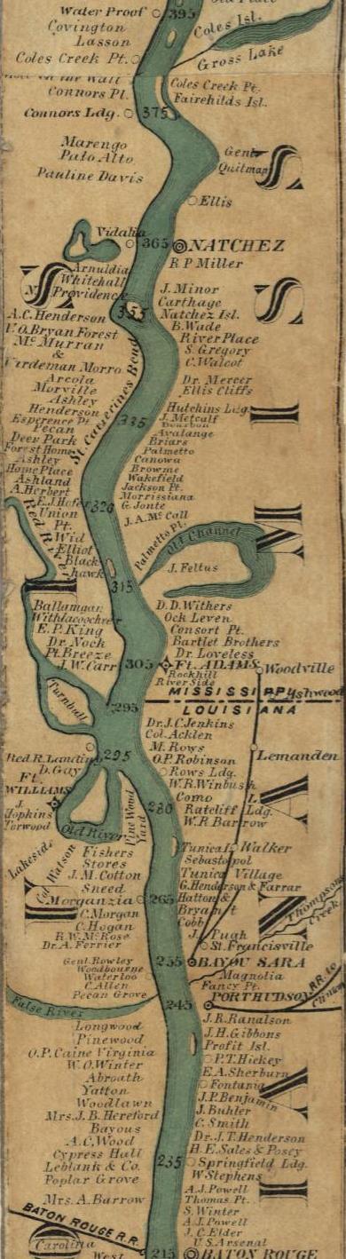
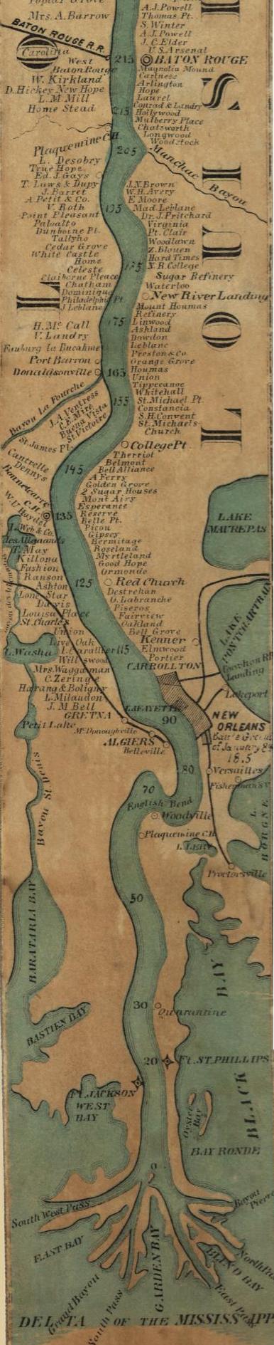
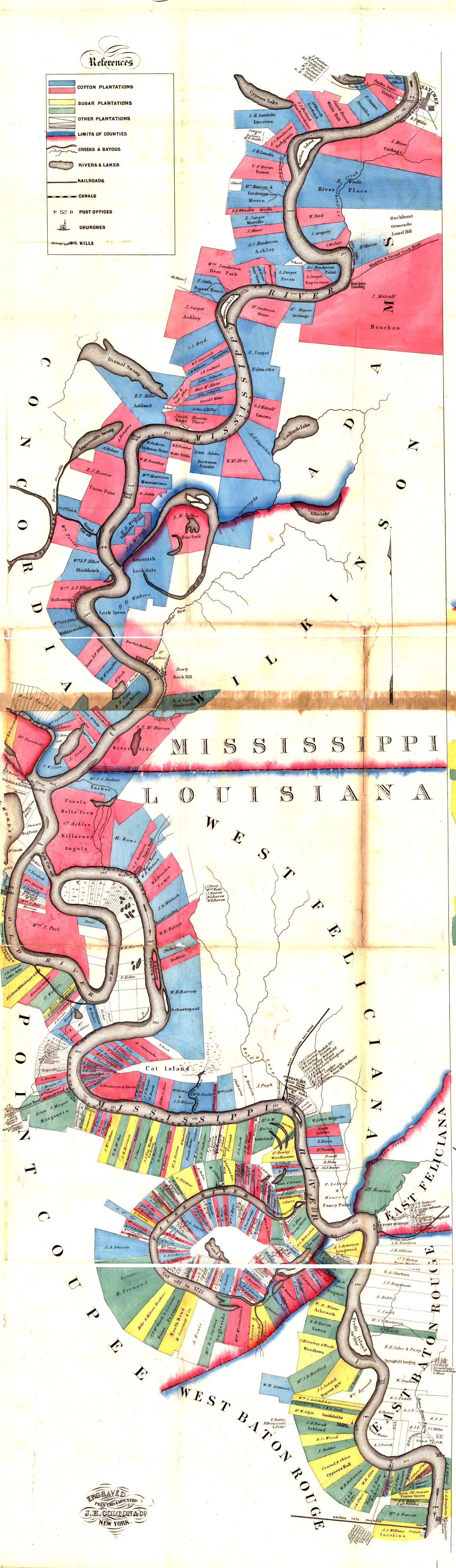 LA-MS 1858— 962k. Natchez to Baton Rouge showing land owners on both sides of river. Modified from Norman's chart of the lower Mississippi River, by A. Persac. Engraved, printed & mounted by J. H. Colton & Co., New York.
Library of Congress.
LA-MS 1858— 962k. Natchez to Baton Rouge showing land owners on both sides of river. Modified from Norman's chart of the lower Mississippi River, by A. Persac. Engraved, printed & mounted by J. H. Colton & Co., New York.
Library of Congress.
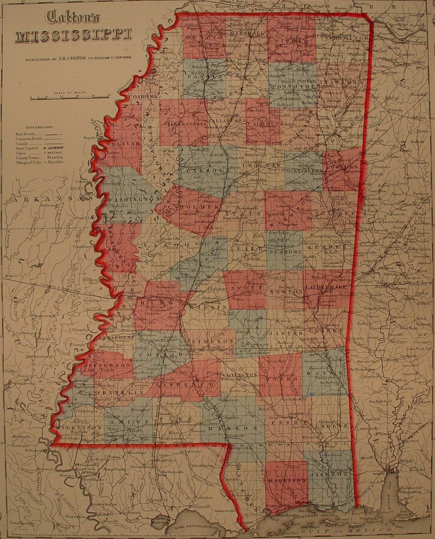
 Mississippi 1859— 630K.
Published by J. H. Colton
& Co., New York. Courtesy of
F. Dean Williams.
Mississippi 1859— 630K.
Published by J. H. Colton
& Co., New York. Courtesy of
F. Dean Williams.
 Mississippi 1862
— 1,246K.
Railroad map showing towns. From Library of Congress.
Mississippi 1862
— 1,246K.
Railroad map showing towns. From Library of Congress.
 Mississippi River-Near Tennessee line to Vicksburg 1862
— 486K.
Fairly detailed. Shows some landowners and plantations. Published by H. L. Lloyd & Co., New York. From Library of Congress.
Mississippi River-Near Tennessee line to Vicksburg 1862
— 486K.
Fairly detailed. Shows some landowners and plantations. Published by H. L. Lloyd & Co., New York. From Library of Congress.
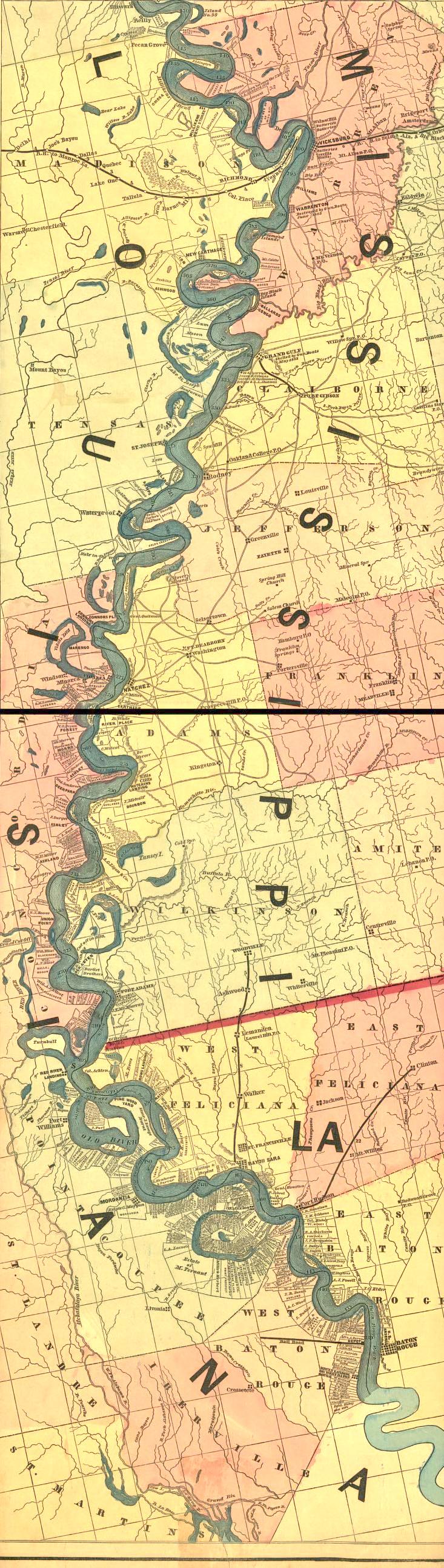 Mississippi River-Vicksburg to Woodville 1862
— 532k.
Fairly detailed. Shows some landowners and plantations. Published by H. L. Lloyd & Co., New York. From Library of Congress.
Mississippi River-Vicksburg to Woodville 1862
— 532k.
Fairly detailed. Shows some landowners and plantations. Published by H. L. Lloyd & Co., New York. From Library of Congress.
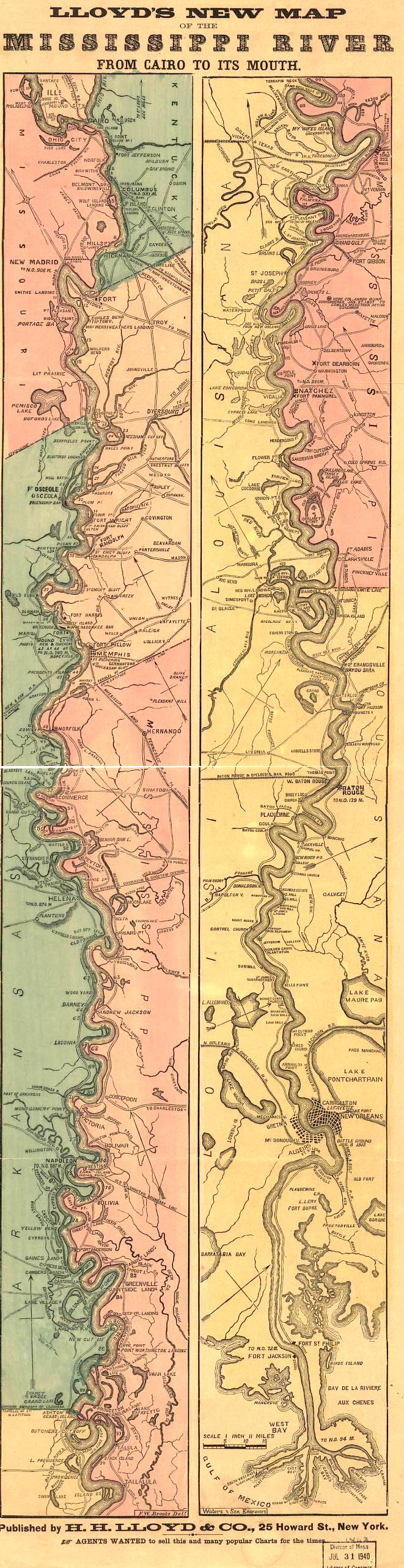 Mississippi River-Cairo, IL to the Gulf 1863
— 453k.
Lloyd’s New Map of the Mississippi.
Published by H. L. Lloyd & Co., New York. From Library of Congress
Mississippi River-Cairo, IL to the Gulf 1863
— 453k.
Lloyd’s New Map of the Mississippi.
Published by H. L. Lloyd & Co., New York. From Library of Congress
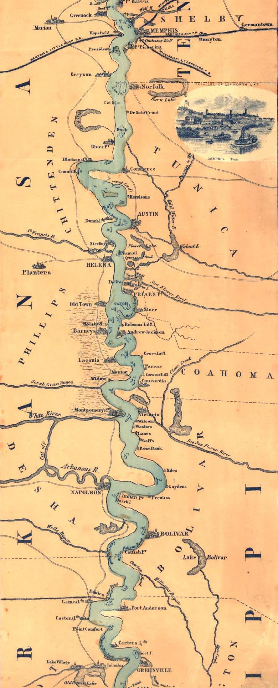 Mississippi River - Memphis to Greenville 1863
— 764K.
Modified from Panorama of the Mississippi Valley : and its fortifications by F.W. Boell. Shows towns, railroads, river landings, some plantations, etc.
Library of Congress.
Mississippi River - Memphis to Greenville 1863
— 764K.
Modified from Panorama of the Mississippi Valley : and its fortifications by F.W. Boell. Shows towns, railroads, river landings, some plantations, etc.
Library of Congress.
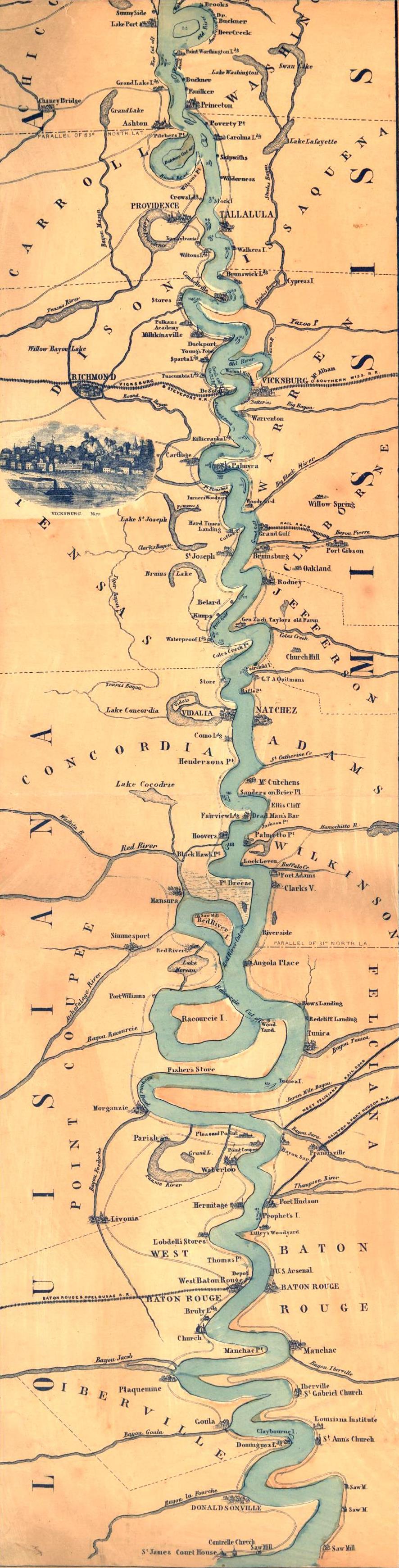 Mississippi River - Greenville to St. James 1863
— 508k.
Modified from Panorama of the Mississippi Valley : and its fortifications by F.W. Boell. Shows towns, railroads, river landings, some plantations, etc.
Library of Congress.
Mississippi River - Greenville to St. James 1863
— 508k.
Modified from Panorama of the Mississippi Valley : and its fortifications by F.W. Boell. Shows towns, railroads, river landings, some plantations, etc.
Library of Congress.
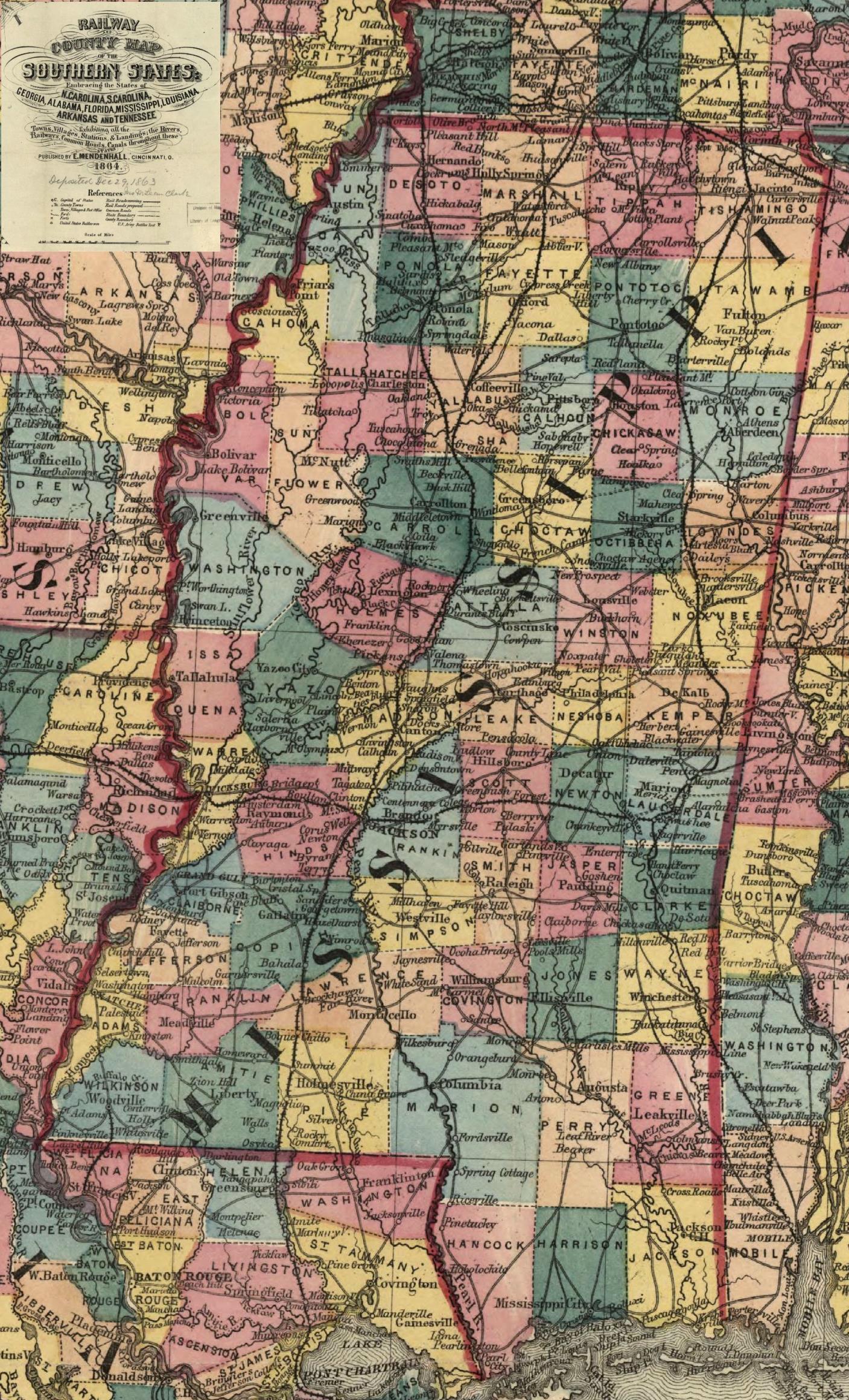 Mississippi 1864
— 764K.
From "Railroad and County Map of the Southern States Exhibiting all the Towns, Villages, Stations and Landings; the Rivers, Railways, Common Roads, Canals, throughout these States. Published by E. Mendenhall, Cincinnati, O., 1864."
From Library of Congress.
Mississippi 1864
— 764K.
From "Railroad and County Map of the Southern States Exhibiting all the Towns, Villages, Stations and Landings; the Rivers, Railways, Common Roads, Canals, throughout these States. Published by E. Mendenhall, Cincinnati, O., 1864."
From Library of Congress.
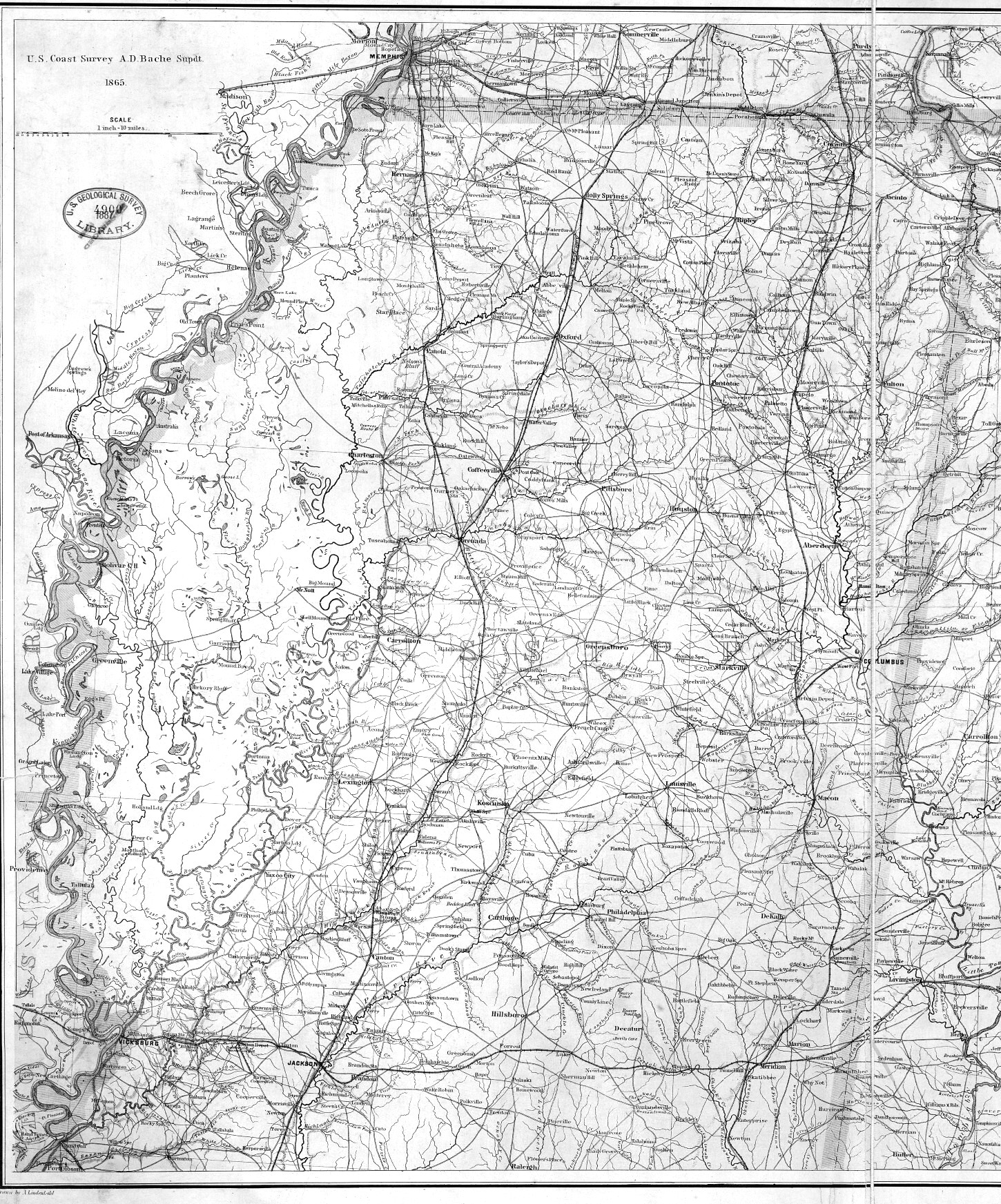 Mississippi 1865
— 1,246K.
Fairly detailed map showing towns, roads, railroads and topography. By U. S. Coast Survey. From Library of Congress.
Mississippi 1865
— 1,246K.
Fairly detailed map showing towns, roads, railroads and topography. By U. S. Coast Survey. From Library of Congress.
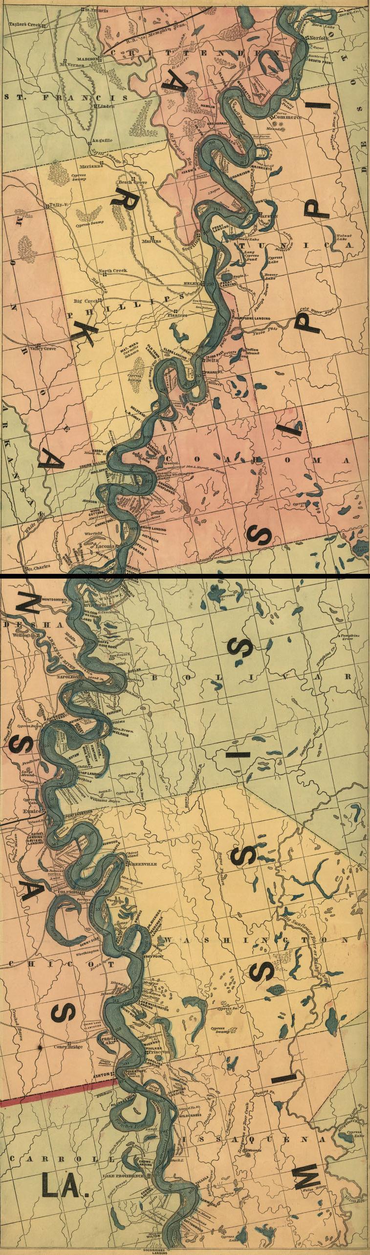
 Mississippi River 1866 Memphis to White River
— 91K.
Ribbon map designed for a steamboat traveler. Published by Coloney and Fairchild, St. Louis, Mo. 1866. Shows distances, landings and some landowners.
From Library of Congress.
Mississippi River 1866 Memphis to White River
— 91K.
Ribbon map designed for a steamboat traveler. Published by Coloney and Fairchild, St. Louis, Mo. 1866. Shows distances, landings and some landowners.
From Library of Congress.
 Mississippi River 1866 White River to LA Line
— 84K.
Same as above.
From Library of Congress.
Mississippi River 1866 White River to LA Line
— 84K.
Same as above.
From Library of Congress.
 Mississippi River 1866 LA Line to Waterproof, LA
— 103K.
Same as above.
From Library of Congress.
Mississippi River 1866 LA Line to Waterproof, LA
— 103K.
Same as above.
From Library of Congress.
 Mississippi River 1866 Waterproof, LA to Baton Rouge
— 116K.
Same as above.
From Library of Congress.
Mississippi River 1866 Waterproof, LA to Baton Rouge
— 116K.
Same as above.
From Library of Congress.
 Mississippi River 1866 Baton Rouge to Gulf
— 135K.
Same as above.
From Library of Congress.
Mississippi River 1866 Baton Rouge to Gulf
— 135K.
Same as above.
From Library of Congress.
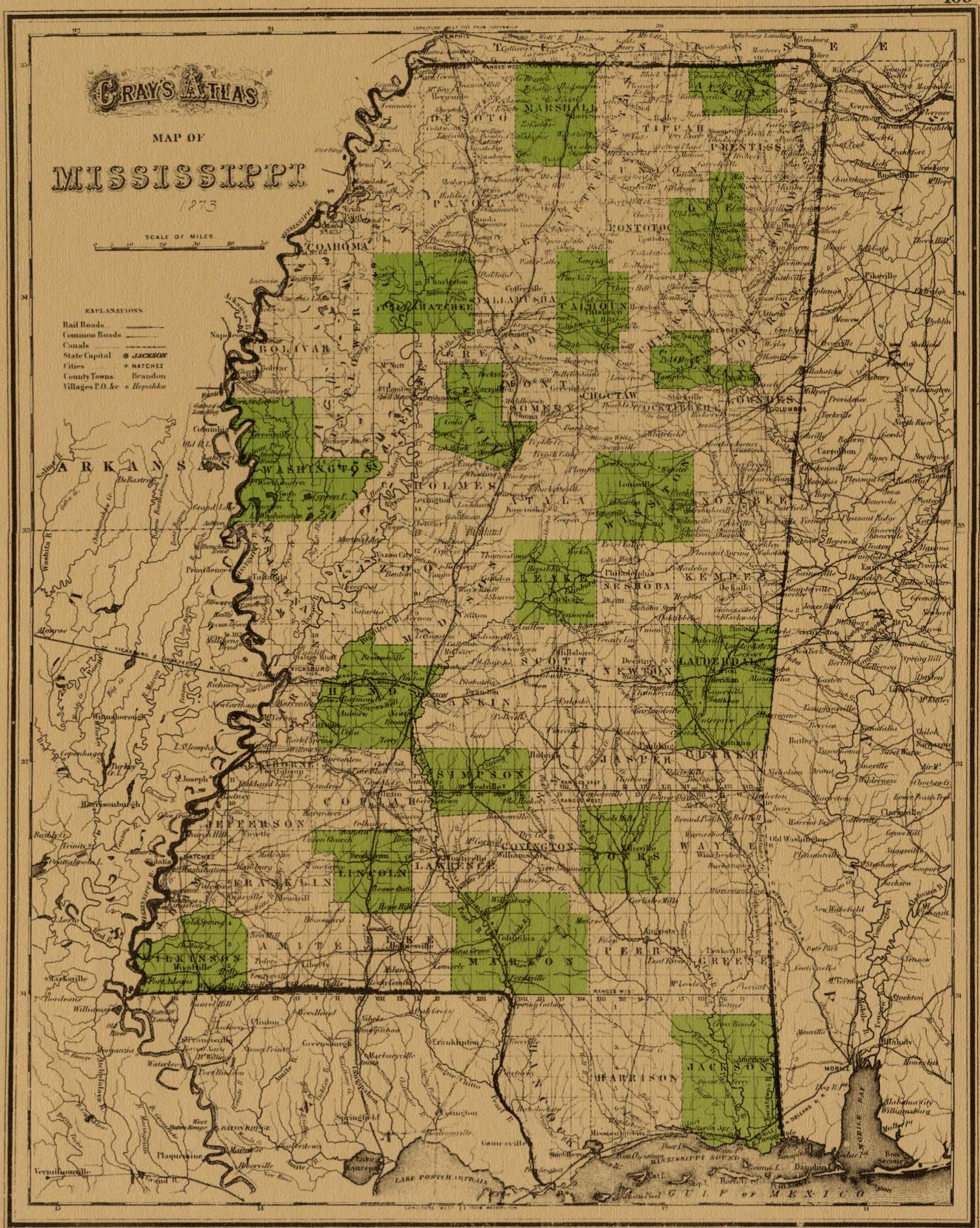 Mississippi 1873
— 646K.
Circa 1873 showing towns, counties and roads. From Gray’s Atlas.
Mississippi 1873
— 646K.
Circa 1873 showing towns, counties and roads. From Gray’s Atlas.
 Mississippi 1874 Flood
— 637K. Shows effects of 1874 Mississippi River Flood. New Orleans Times-Picayune. From
Library of Congress.
Mississippi 1874 Flood
— 637K. Shows effects of 1874 Mississippi River Flood. New Orleans Times-Picayune. From
Library of Congress.
 Mississippi 1878
— 1,380K.
Cram's railroad & township map of Mississippi / published by Geo. F. Cram.
From Library of Congress.
Mississippi 1878
— 1,380K.
Cram's railroad & township map of Mississippi / published by Geo. F. Cram.
From Library of Congress.
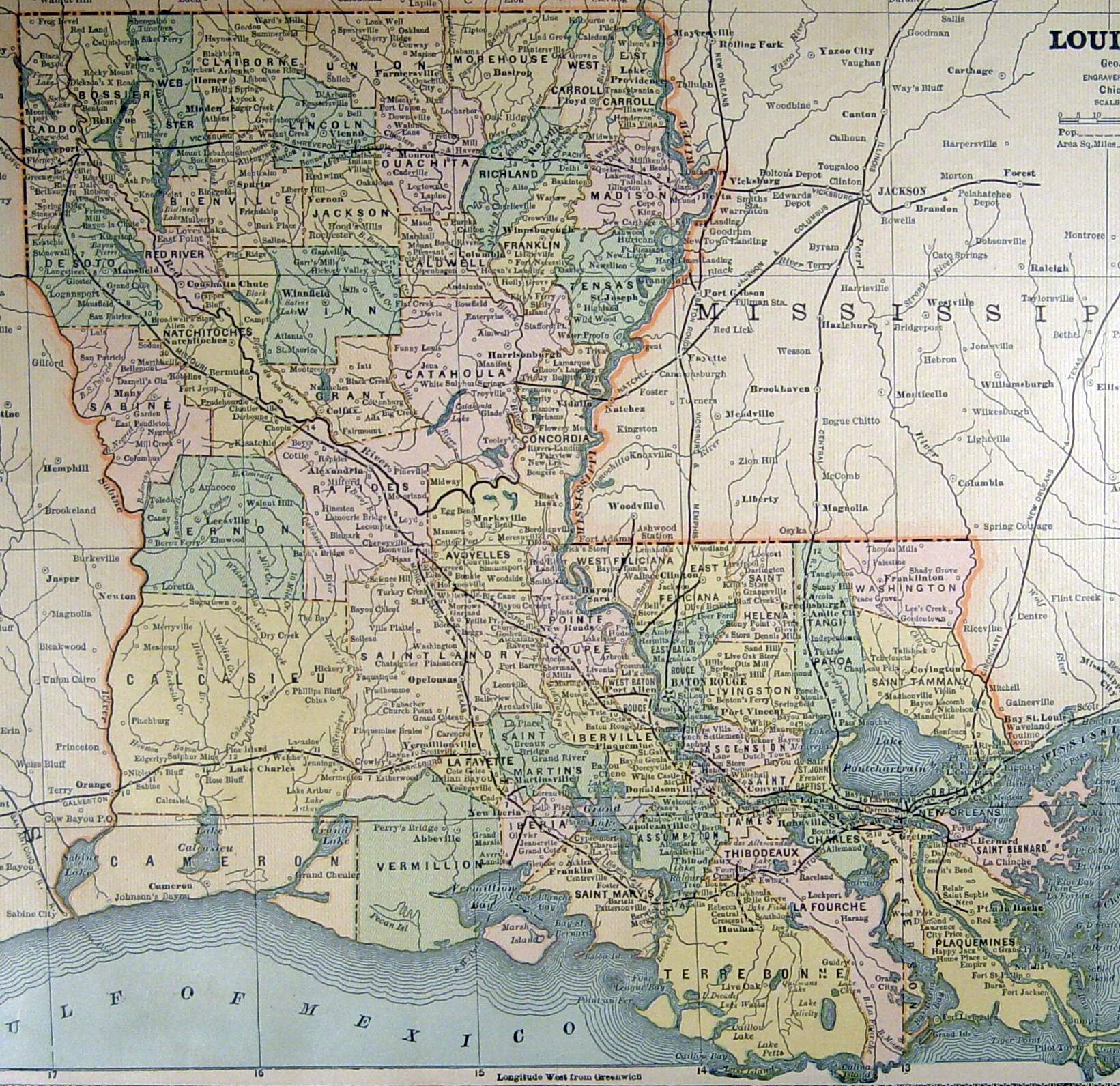
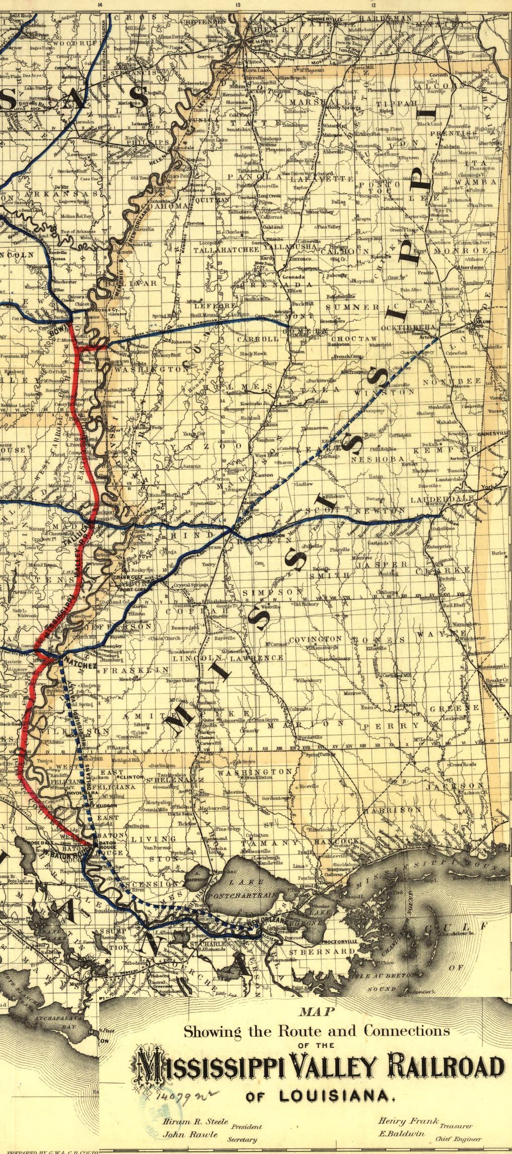 Mississippi 1882
— 706K.
From "Map Showing Route and Connections of the Mississippi Valley Railroad of Louisiana. G. B. and C. B. Colton Co., New York 1882." From Library of Congress.
Mississippi 1882
— 706K.
From "Map Showing Route and Connections of the Mississippi Valley Railroad of Louisiana. G. B. and C. B. Colton Co., New York 1882." From Library of Congress.

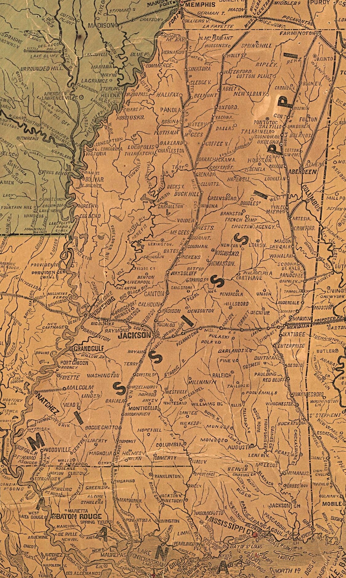
Mississippi 1884
— 898k. Memphis to Natchez
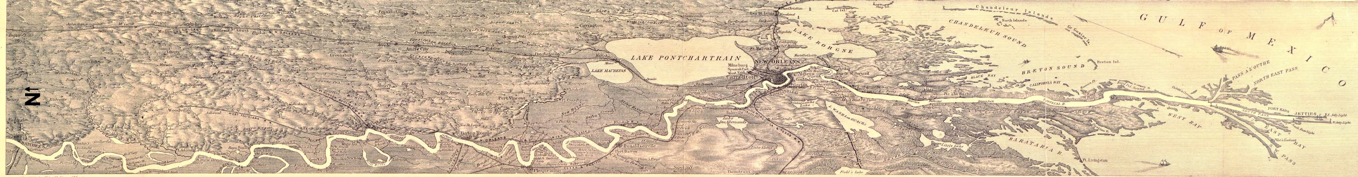
Mississippi 1884
— 775k. Natchez to Gulf
Bird's-eye views of the Mississippi River from Memphis to Natchez. Drawn & engraved by Edward Molitor, T.E. An interesting overhead view covering a swath approximately 100 miles wide showing detailed towns, lakes & streams, railroads, etc.
From Library of Congress.
 Mississippi 1885
— 456K.
By George F. Cram, Engraver and
Publisher, Chicago, IL.
Courtesy of F. Dean Williams.
Mississippi 1885
— 456K.
By George F. Cram, Engraver and
Publisher, Chicago, IL.
Courtesy of F. Dean Williams.
 Mississippi 1888 (North Half)
— 1,175K. North half of detailed Railroad Map Published by Rand, McNally. From Library of Congress.
Mississippi 1888 (North Half)
— 1,175K. North half of detailed Railroad Map Published by Rand, McNally. From Library of Congress.
 Mississippi 1888 (South Half)
— 1,586K. South half of same map.
Mississippi 1888 (South Half)
— 1,586K. South half of same map.
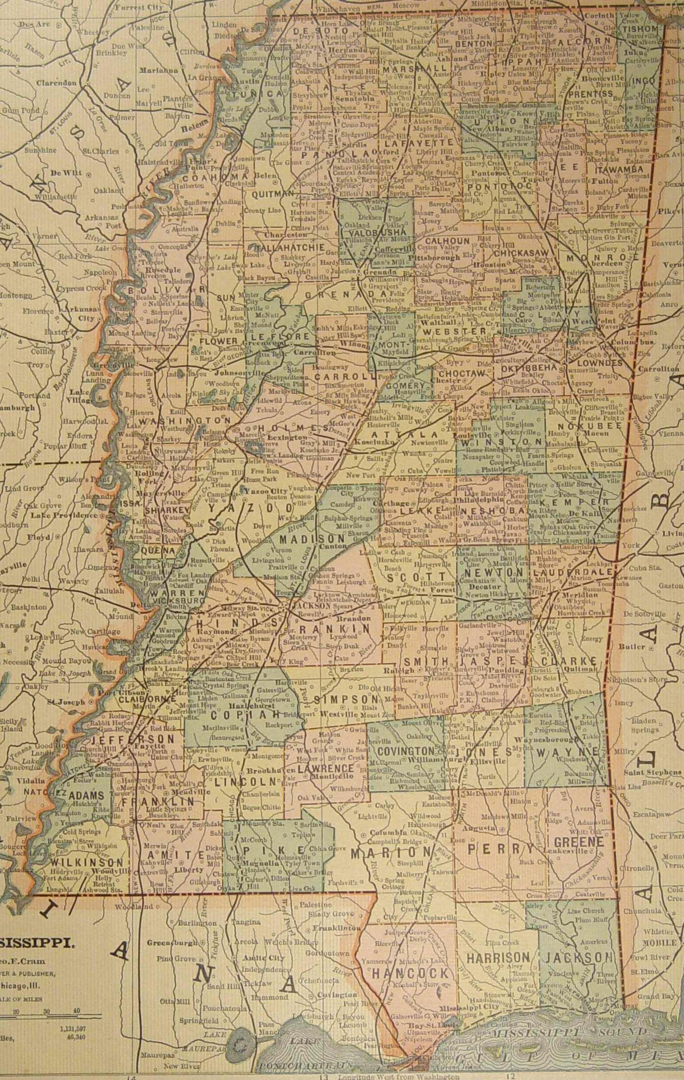
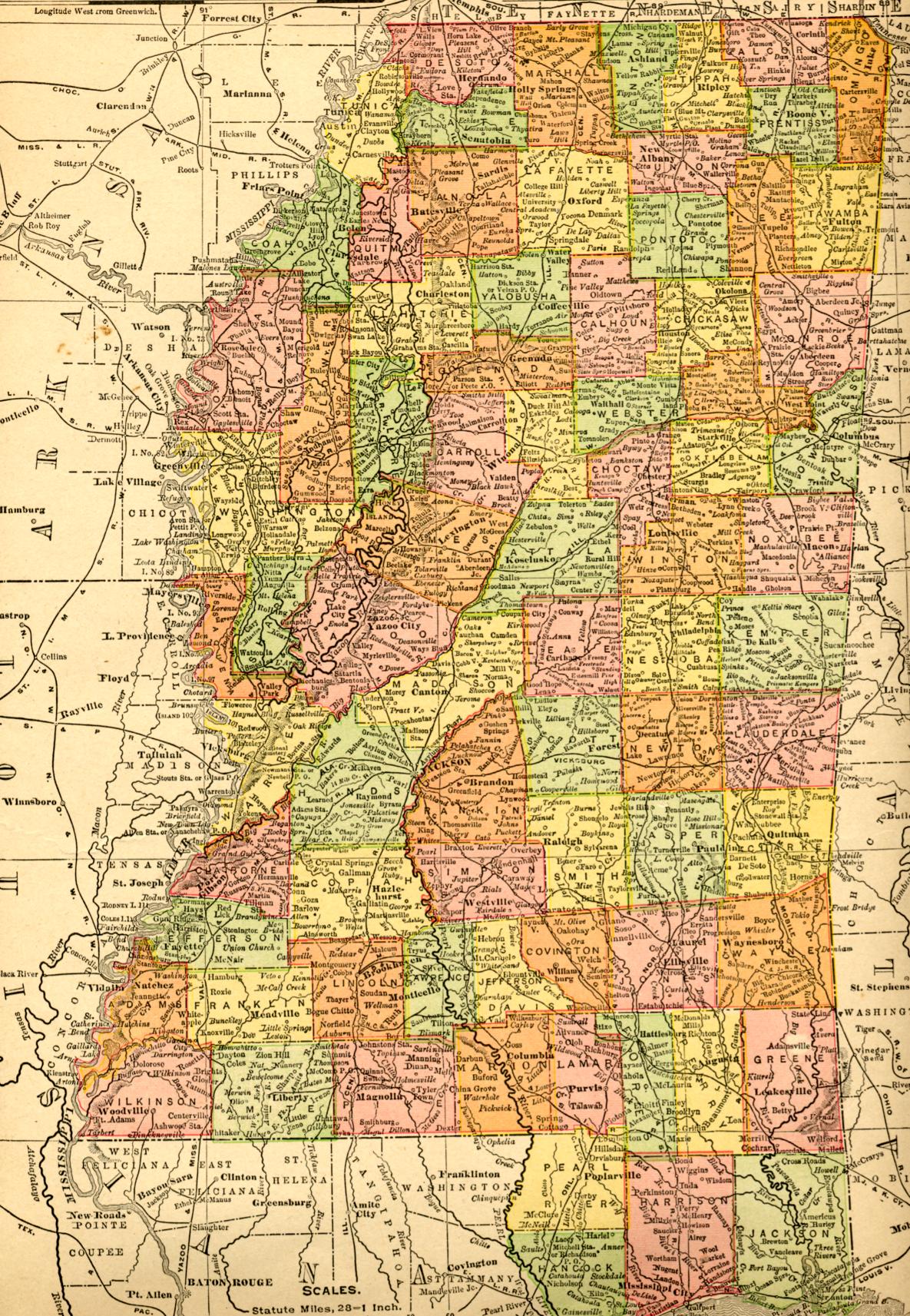
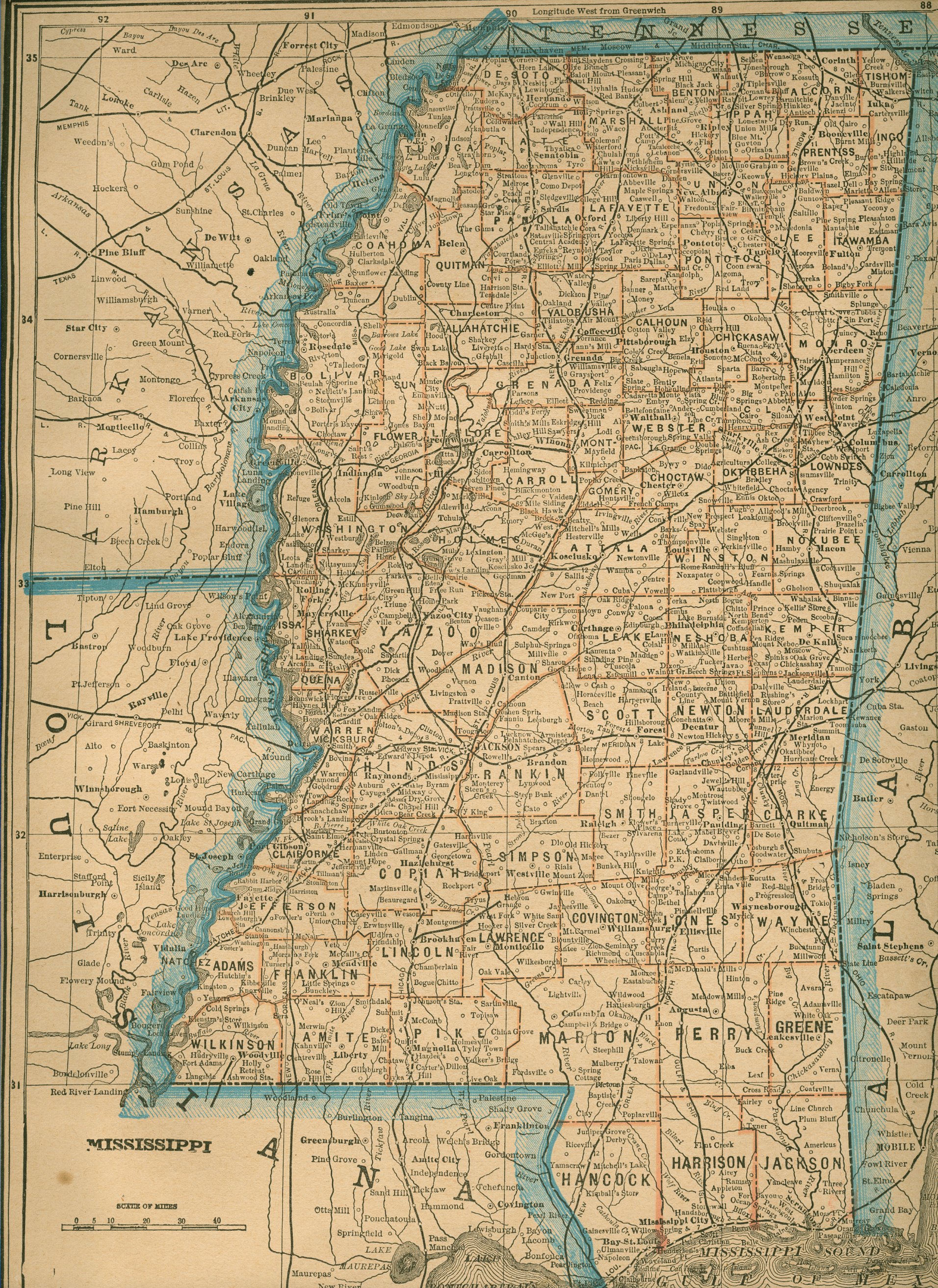 Mississippi 1893 — 1,910K.
Map showing cities, towns and county lines for all of Mississippi and portions of Louisiana & Arkansas. Courtesy of Elaine Vechorik, Sturgis Soap Factory, Sturgis, MS.
Mississippi 1893 — 1,910K.
Map showing cities, towns and county lines for all of Mississippi and portions of Louisiana & Arkansas. Courtesy of Elaine Vechorik, Sturgis Soap Factory, Sturgis, MS.
 Mississippi 1907
— 645K.
Map from Rand McNally & Co.’s New Ideal State and County Survey and Atlas 1907.
Mississippi 1907
— 645K.
Map from Rand McNally & Co.’s New Ideal State and County Survey and Atlas 1907.
. Mississippi Indian Land Cessions 1899
— 456K.
Cessions of Indian Lands from the time of the establishment of the U.S. Government to 1894. Also shows townships and ranges. For more information click here. From
Indian Land Cessions in the United States, U.S. Government Printing Office 1899.
Mississippi Indian Land Cessions 1899
— 456K.
Cessions of Indian Lands from the time of the establishment of the U.S. Government to 1894. Also shows townships and ranges. For more information click here. From
Indian Land Cessions in the United States, U.S. Government Printing Office 1899.
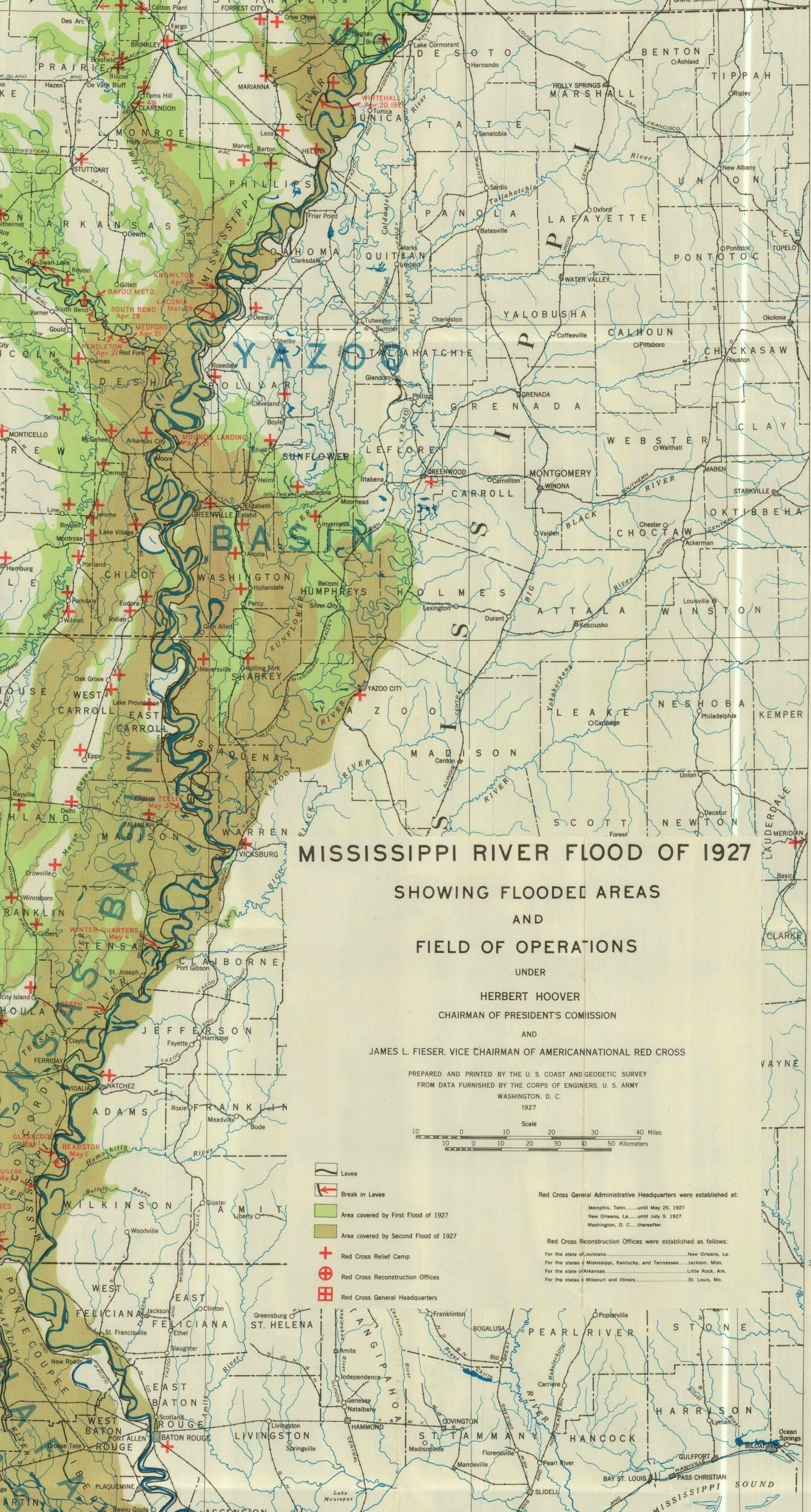 1927 Mississippi River Flood
— 840K.
Detailed map of the areas effected by the 1927 Flood showing flooded areas and field of operations. Prepared by the U. S. Coast and Geodetic Survey from data supplied by the U. S. Army Corps of Engineers. Courtesy of Brad Edmondson.
1927 Mississippi River Flood
— 840K.
Detailed map of the areas effected by the 1927 Flood showing flooded areas and field of operations. Prepared by the U. S. Coast and Geodetic Survey from data supplied by the U. S. Army Corps of Engineers. Courtesy of Brad Edmondson.
![]()
Recent county maps may be found on the Mississippi Department of Transportation (MDOT) website by clicking here.
![]()
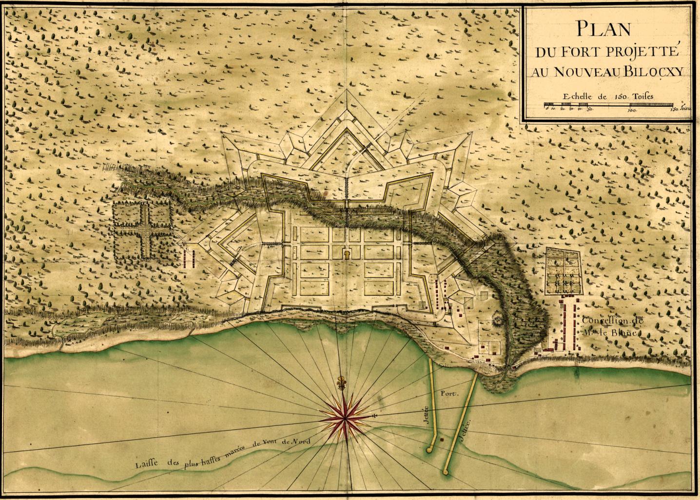 Biloxi 1721
— 328K.
“Plan du fort projetté au Nouveau Bilocxy”.
From Library of Congress.
Biloxi 1721
— 328K.
“Plan du fort projetté au Nouveau Bilocxy”.
From Library of Congress.
 Iuka 1862 — 104K.
By Michel Lèvy, Fréres – Paris.
Original at Choctaw Books, Jackson, MS.
Iuka 1862 — 104K.
By Michel Lèvy, Fréres – Paris.
Original at Choctaw Books, Jackson, MS.
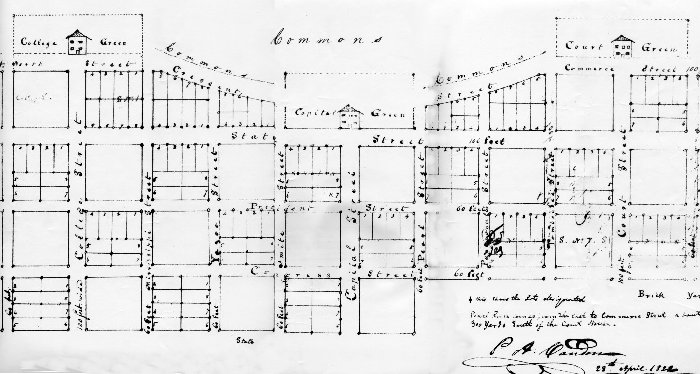
 Jackson 1822
— 235K.
Old city plat of Jackson dated April 29th, 1822. Courtesy of Charles Brenner, Eudora Welty Library, Jackson, MS.
Jackson 1822
— 235K.
Old city plat of Jackson dated April 29th, 1822. Courtesy of Charles Brenner, Eudora Welty Library, Jackson, MS.
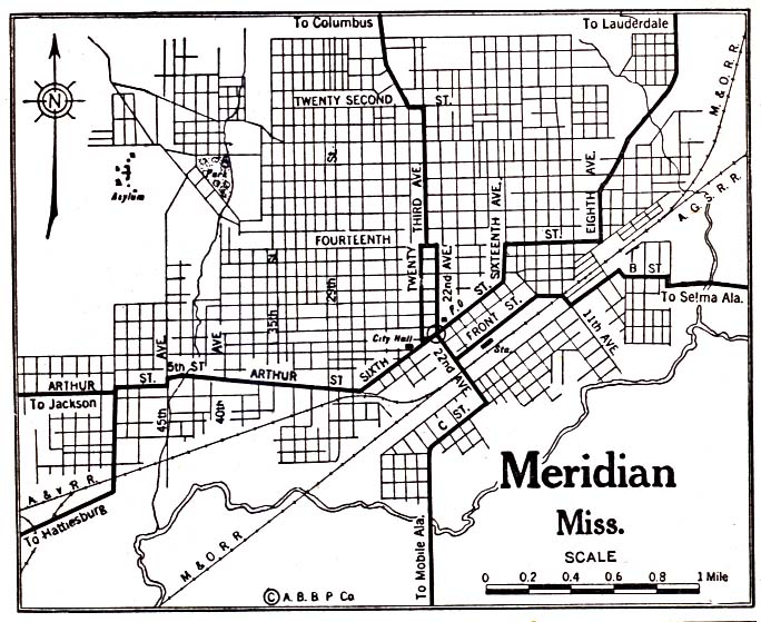
 Meridian 1920
— 118K.
From Library of Congress.
Meridian 1920
— 118K.
From Library of Congress.
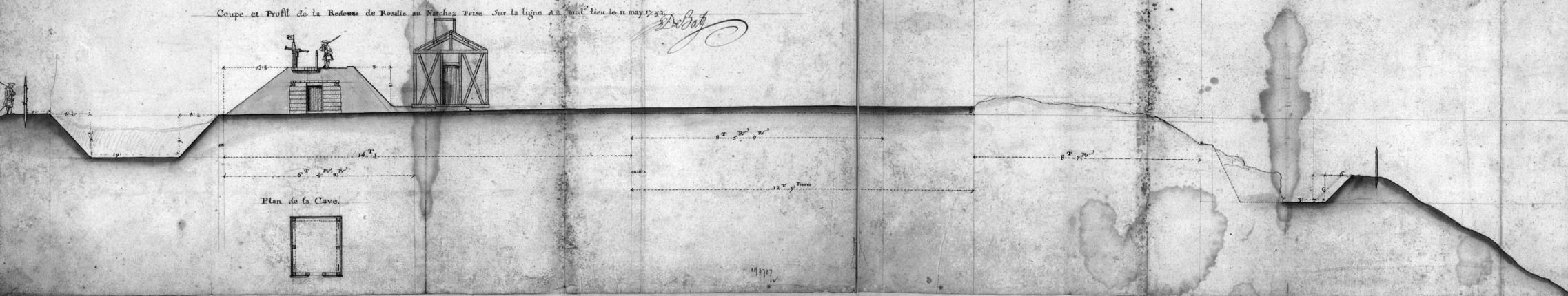
![]() Natchez (Ft. Rosalie) 1732
—
147K.
Elevation view of the fort. From Library of Congress.
Natchez (Ft. Rosalie) 1732
—
147K.
Elevation view of the fort. From Library of Congress.

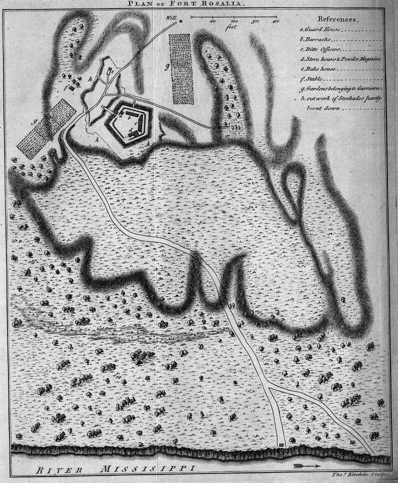
Natchez (Ft. Rosalie) 1770
— 511K.
Plan view of the fort. Published in London for J. Nourse. From Library of Congress.
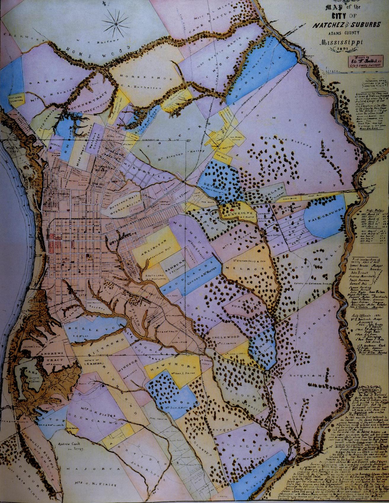 Natchez 1891
— 487 K.
1891
map of Natchez and suburbs showing landowners, plantations and antebellum homes in color. Courtesy of Thomas H. and Joan W. Gandy
Natchez 1891
— 487 K.
1891
map of Natchez and suburbs showing landowners, plantations and antebellum homes in color. Courtesy of Thomas H. and Joan W. Gandy
![]()
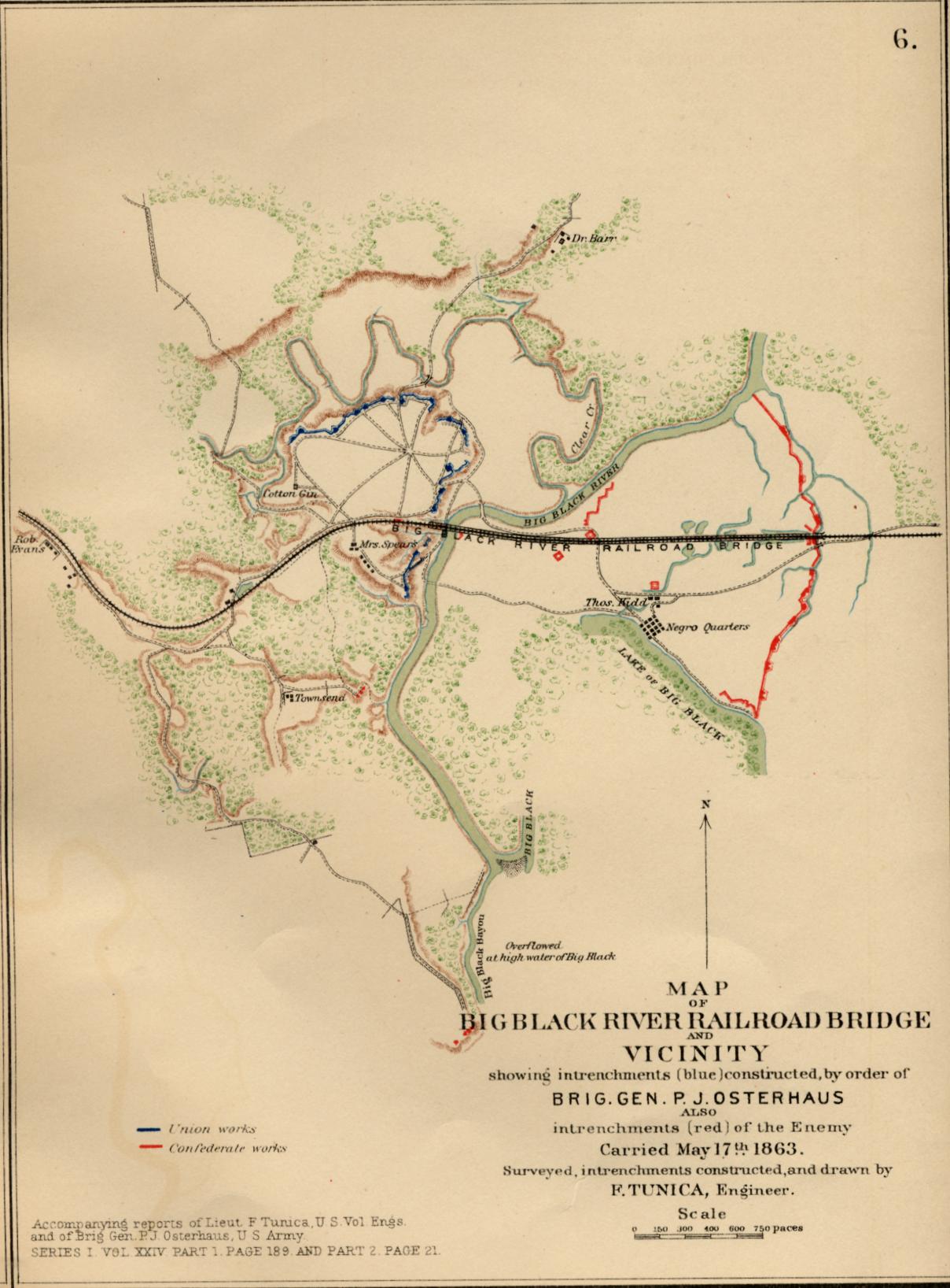
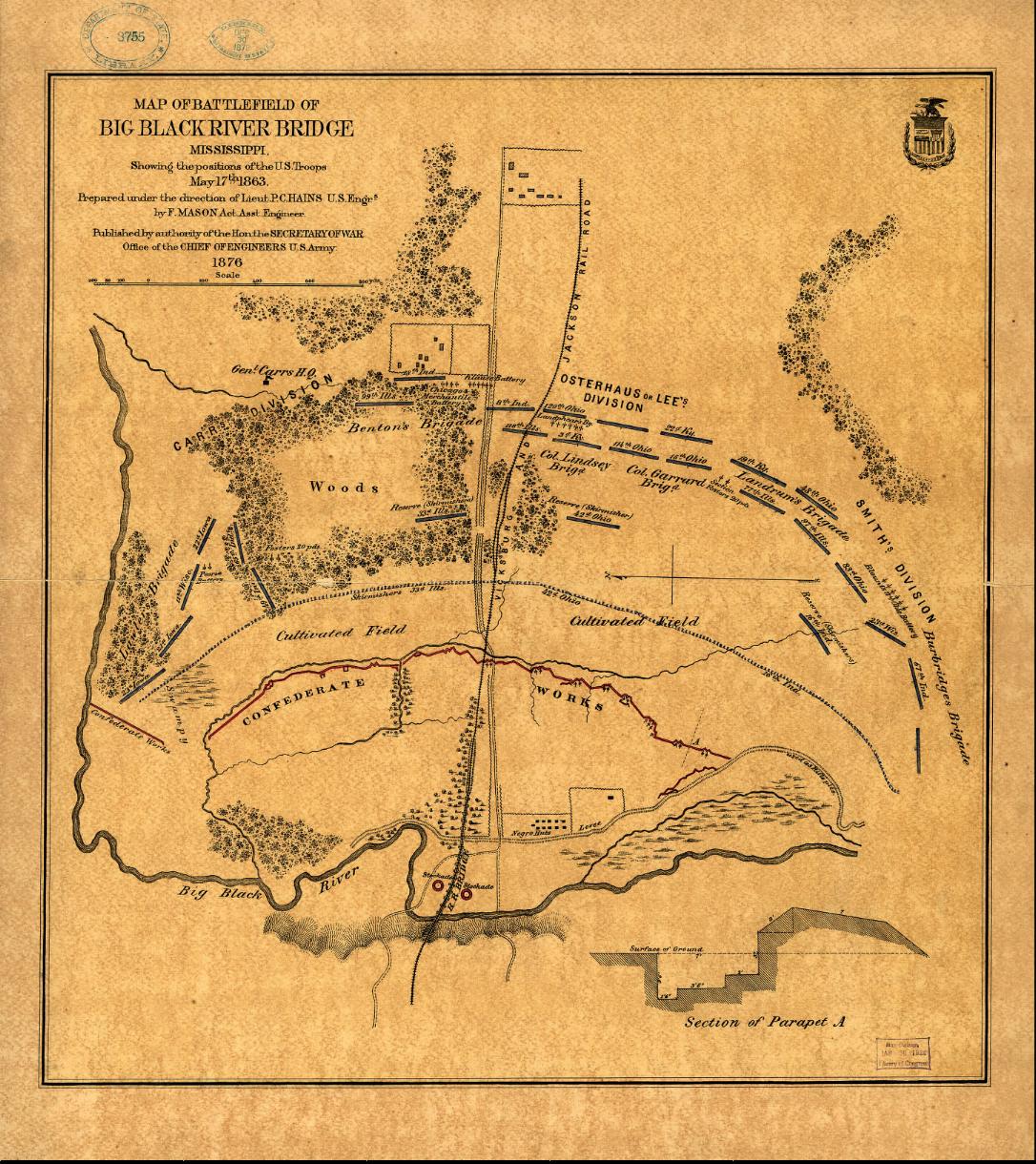
 Battle of Big Black River Bridge 1863
— 326K.
Shows
position of troops on May 17, 1863. From Library of Congress.
Battle of Big Black River Bridge 1863
— 326K.
Shows
position of troops on May 17, 1863. From Library of Congress.
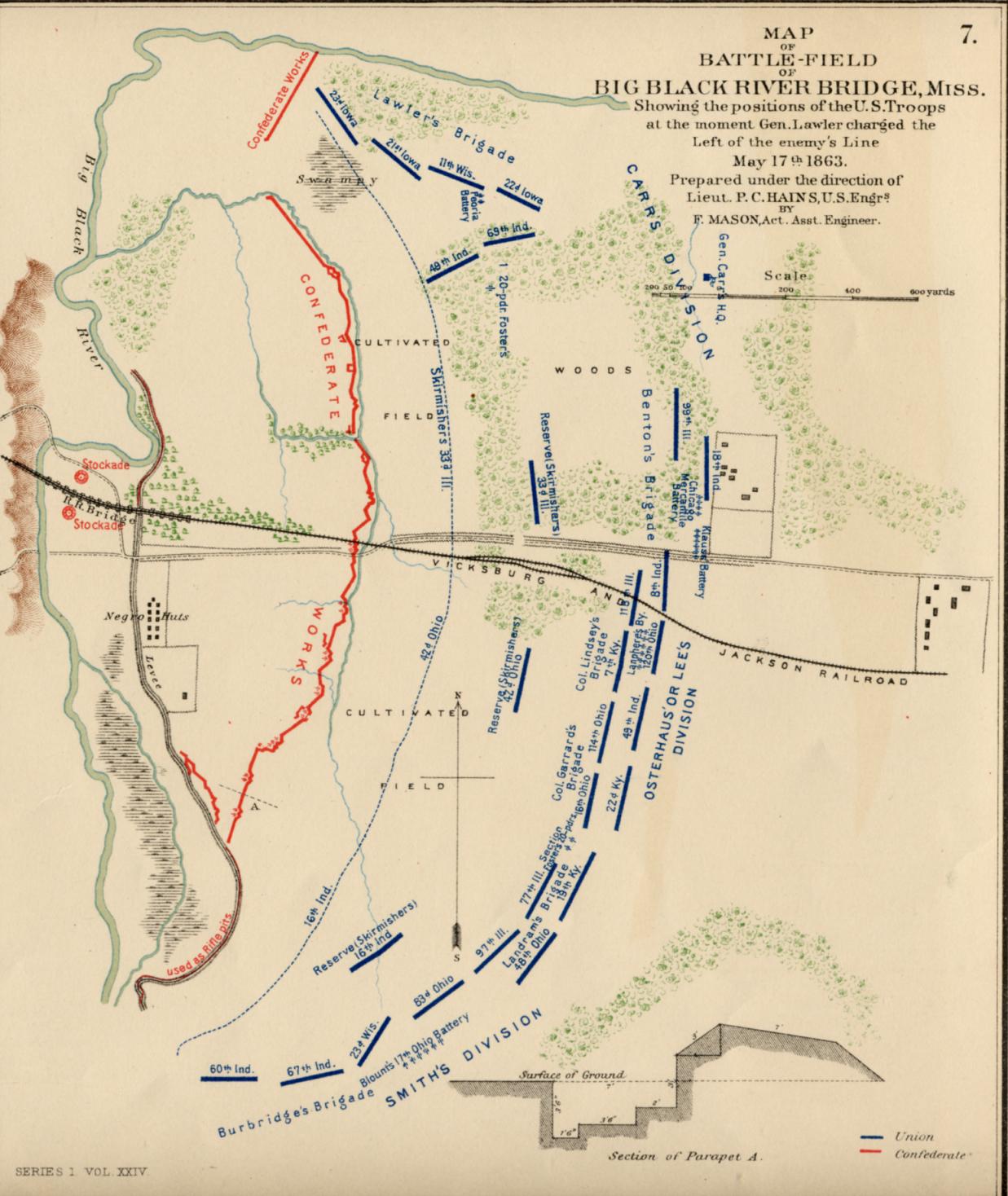
 Battle of Big Black River Bridge 1863
— 207K.
Shows detailed positions of Union troops in color at the moment of Gen. Lawler’s charge on May 17, 1863. From PLATE XXXVII – map 7 of the Atlas to Accompany the Official Records of the Union and Confederate Armies 1861-1865. (More detailed than map above) Original at Choctaw Books, Jackson, MS.
Battle of Big Black River Bridge 1863
— 207K.
Shows detailed positions of Union troops in color at the moment of Gen. Lawler’s charge on May 17, 1863. From PLATE XXXVII – map 7 of the Atlas to Accompany the Official Records of the Union and Confederate Armies 1861-1865. (More detailed than map above) Original at Choctaw Books, Jackson, MS.
 Battle of Big Black River Bridge 1863
— 207K.
Shows “intrenchments” of Confederate and Union armies in color. From PLATE XXXVII – map 6 of the Atlas to Accompany the Official Records of the Union and Confederate Armies 1861-1865. Original at Choctaw Books, Jackson, MS.
Battle of Big Black River Bridge 1863
— 207K.
Shows “intrenchments” of Confederate and Union armies in color. From PLATE XXXVII – map 6 of the Atlas to Accompany the Official Records of the Union and Confederate Armies 1861-1865. Original at Choctaw Books, Jackson, MS.
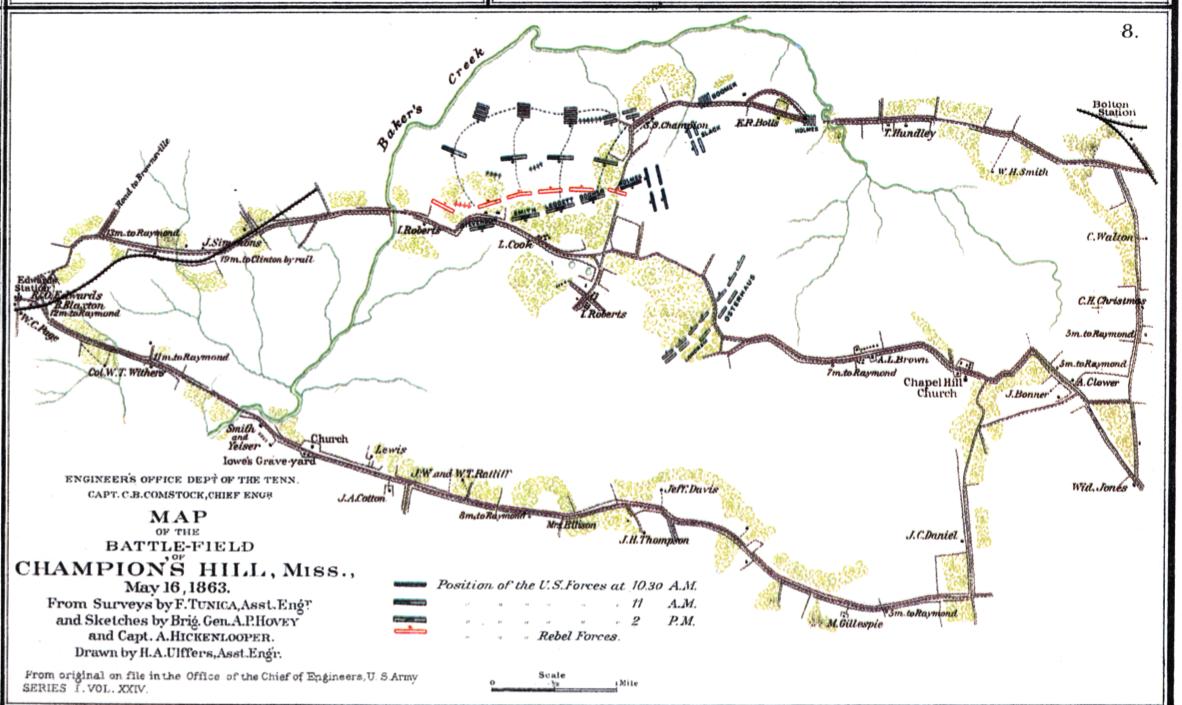
 Battle of Champion’s Hill
— 106K.
May
16th 1863. Shown positions of Confederate & Union troops and some landowners. From PLATE CXXII – map 8 of the Atlas to Accompany the Official Records of the Union and Confederate Armies 1861-1865. Courtesy of L. Graham Hughes.
Battle of Champion’s Hill
— 106K.
May
16th 1863. Shown positions of Confederate & Union troops and some landowners. From PLATE CXXII – map 8 of the Atlas to Accompany the Official Records of the Union and Confederate Armies 1861-1865. Courtesy of L. Graham Hughes.
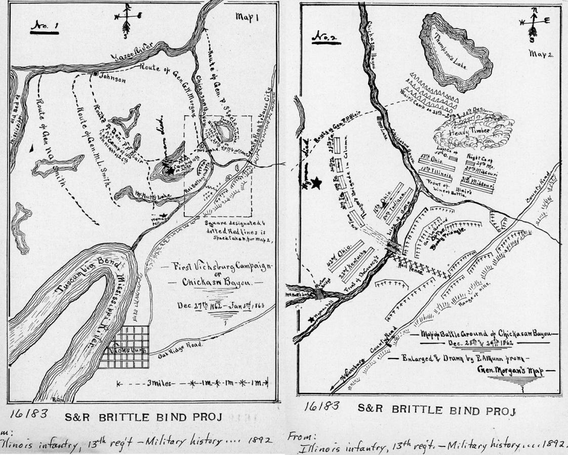 Battle of Chickasaw Bayou 1862
— 205K.
Map
of
first Vicksburg campaign. Dec. 28th and 29th, 1862. Enlarged and drawn by E. A. Munn from Gen. Morgan's map. Military history and reminiscences of the Thirteenth regiment of Illinois volunteer infantry in the Civil War in the United States, 1861-65. Prepared by a committee of the regiment, 1891. Chicago, Woman's Temperance Publishing Association, 1892. From Library of Congress.
Battle of Chickasaw Bayou 1862
— 205K.
Map
of
first Vicksburg campaign. Dec. 28th and 29th, 1862. Enlarged and drawn by E. A. Munn from Gen. Morgan's map. Military history and reminiscences of the Thirteenth regiment of Illinois volunteer infantry in the Civil War in the United States, 1861-65. Prepared by a committee of the regiment, 1891. Chicago, Woman's Temperance Publishing Association, 1892. From Library of Congress.
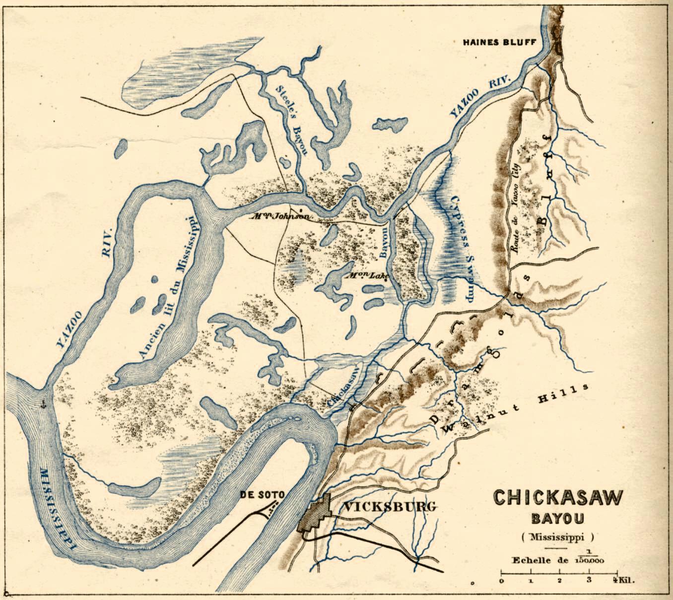
 Battle of Chickasaw Bayou 1862
— 230K.
French map in color with rivers, lakes and swamps in blue and bluffs in brown.
By Michel Lèvy, Fréres – Paris. Original at Choctaw Books, Jackson, MS.
Battle of Chickasaw Bayou 1862
— 230K.
French map in color with rivers, lakes and swamps in blue and bluffs in brown.
By Michel Lèvy, Fréres – Paris. Original at Choctaw Books, Jackson, MS.
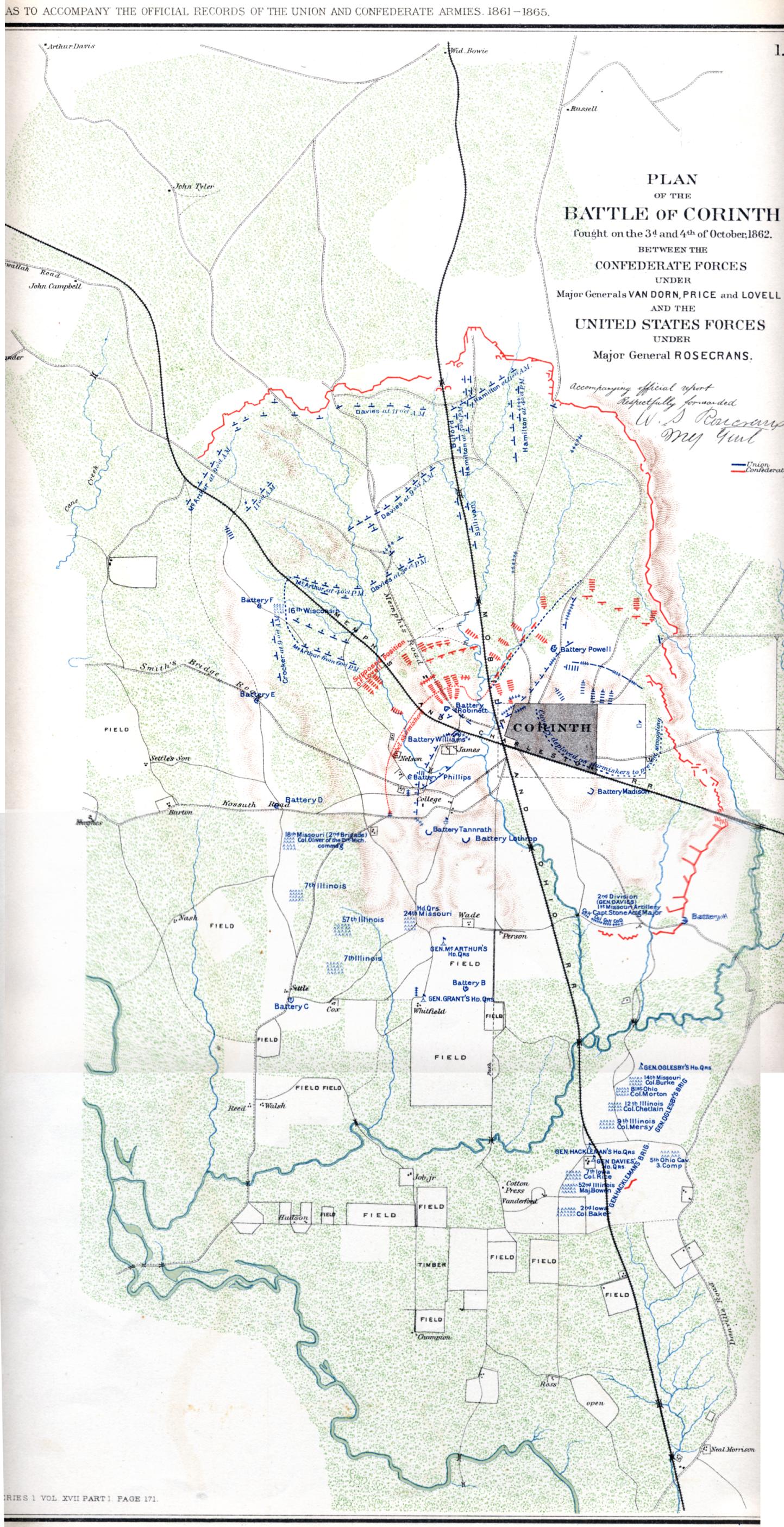
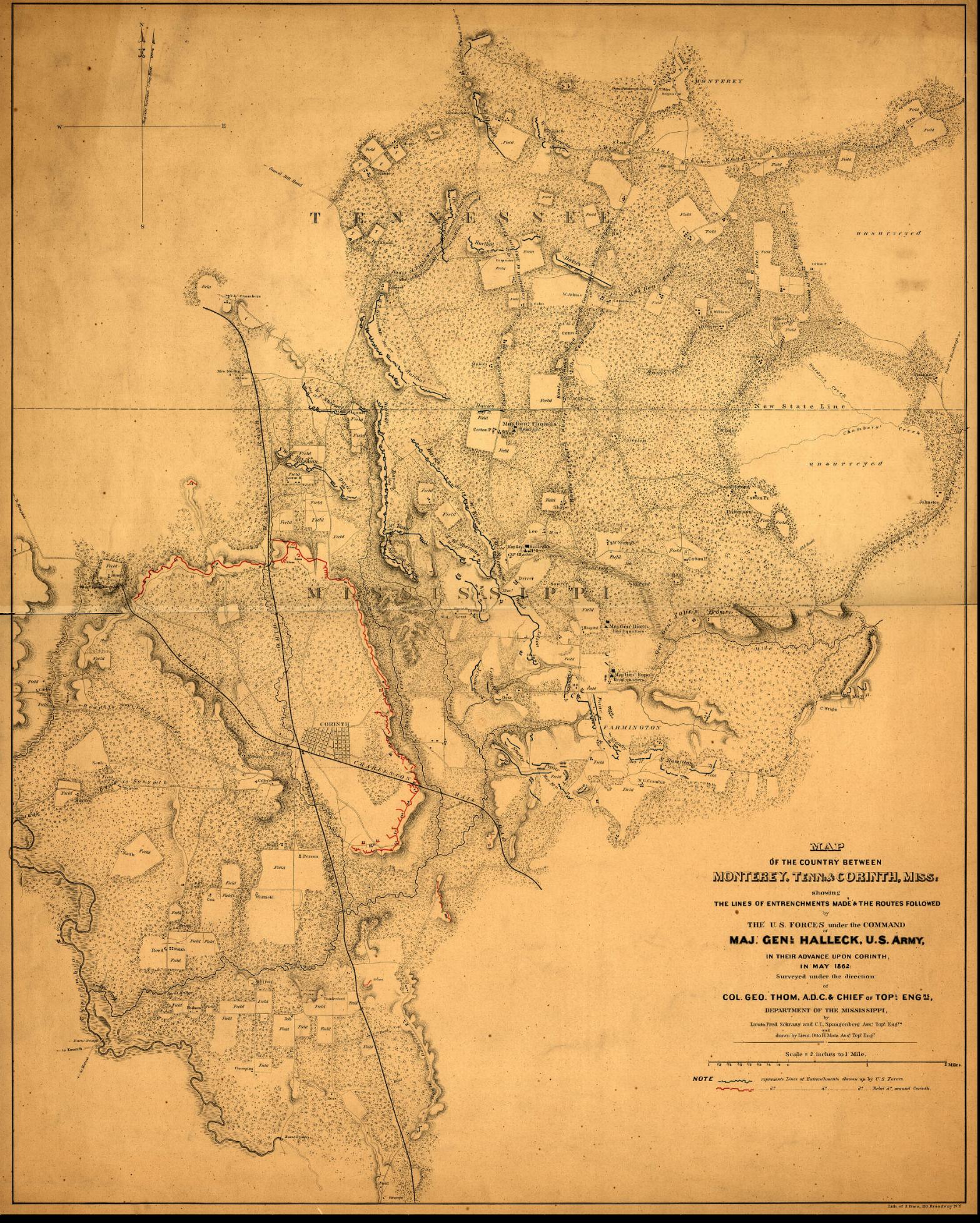 Battle of Corinth 1862
— 720K.
Area between Monterey, TN and Corinth, MS showing Confederate and Union lines of entrenchment prior to the Battle of Corinth. From Library of Congress.
Battle of Corinth 1862
— 720K.
Area between Monterey, TN and Corinth, MS showing Confederate and Union lines of entrenchment prior to the Battle of Corinth. From Library of Congress.
 Battle of Corinth 1862
— 669K.
Detailed color map of battle. From
PLATE XXV – map 1 of the Atlas to Accompany the Official Records of the Union and Confederate Armies 1861-1865.
Original at Choctaw Books, Jackson, MS.
Battle of Corinth 1862
— 669K.
Detailed color map of battle. From
PLATE XXV – map 1 of the Atlas to Accompany the Official Records of the Union and Confederate Armies 1861-1865.
Original at Choctaw Books, Jackson, MS.
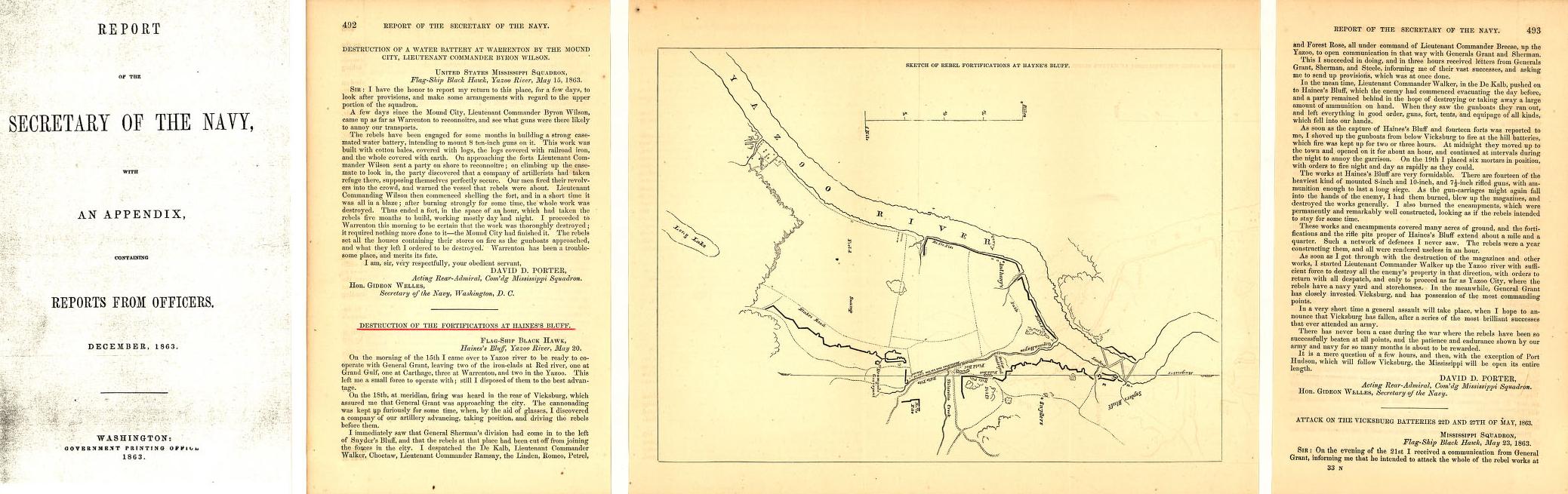
![]() Battle of Haines Bluff 1863
— 257K.
Admiral David Porter’s map and report of the May 1863 Battle of Haines Bluff just north of Vicksburg on the Yazoo River. From Library of Congress.
Battle of Haines Bluff 1863
— 257K.
Admiral David Porter’s map and report of the May 1863 Battle of Haines Bluff just north of Vicksburg on the Yazoo River. From Library of Congress.
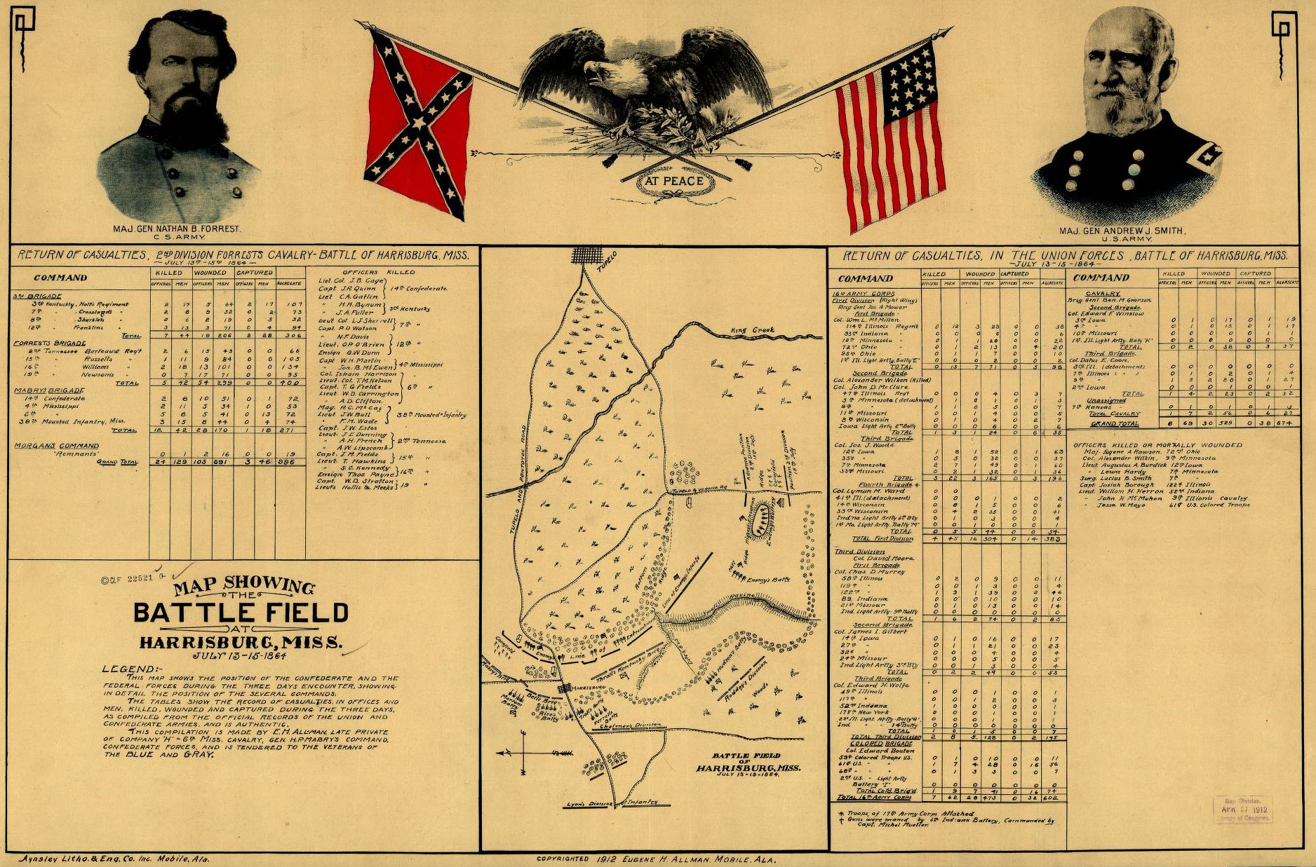 Battle of Harrisburg 1864
— 496K.
Includes both Confederate and Union casualty lists; units involved and names of officers killed during this battle which occurred July 13-16, 1864. From Library of Congress.
Battle of Harrisburg 1864
— 496K.
Includes both Confederate and Union casualty lists; units involved and names of officers killed during this battle which occurred July 13-16, 1864. From Library of Congress.
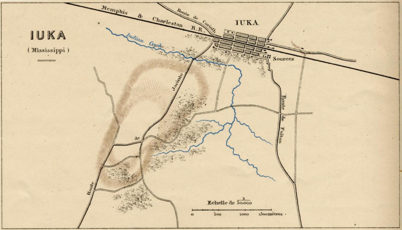
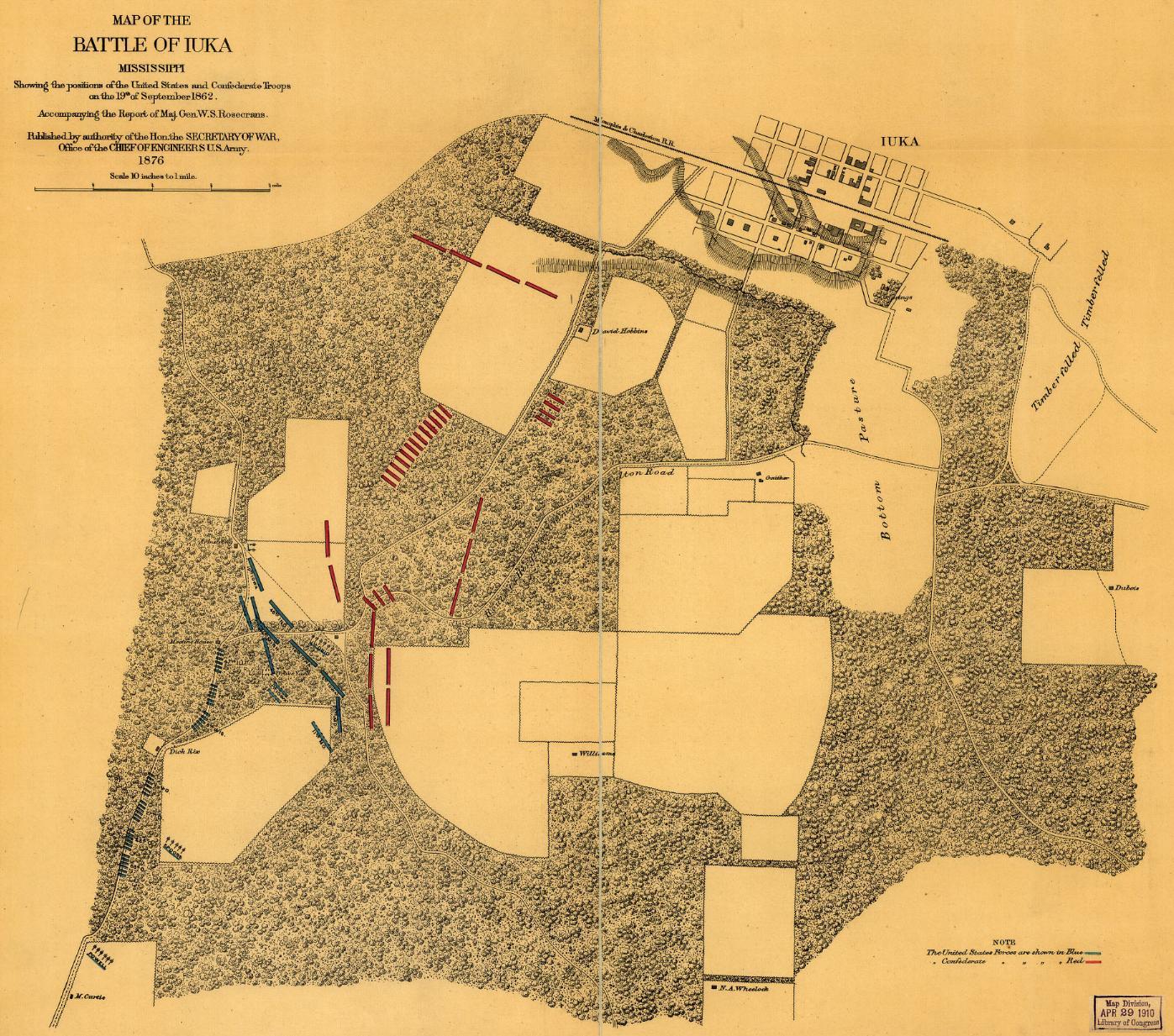
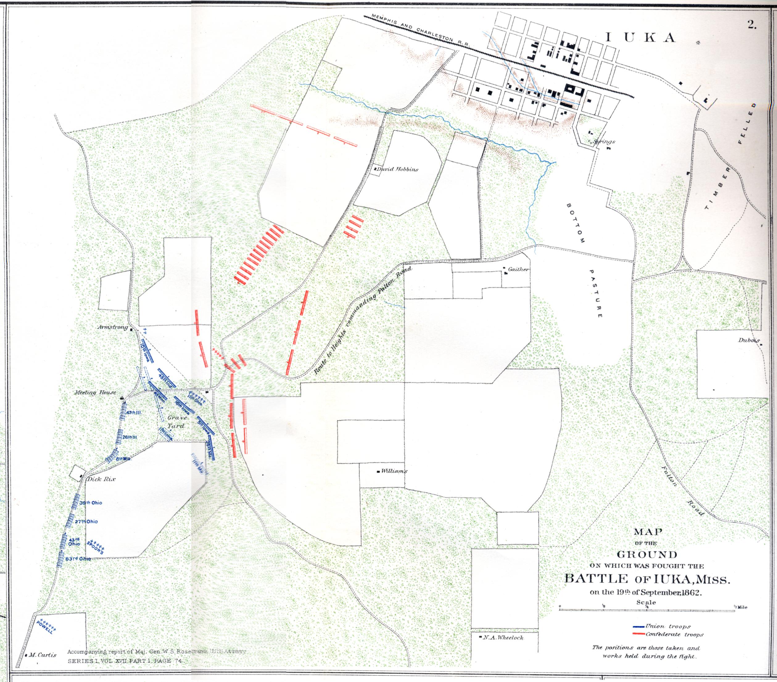
 Battle of Iuka 1862
— 439K.
Shows positions of the Confederate and Union troops on September 19, 1862. From Library of Congress.
Battle of Iuka 1862
— 439K.
Shows positions of the Confederate and Union troops on September 19, 1862. From Library of Congress.
 Battle of Iuka 1862
— 690K.
Detailed color map of battle. From
PLATE XXV – map 2 of the Atlas to Accompany the Official Records of the Union and Confederate Armies 1861-1865.
Original at Choctaw Books, Jackson, MS.
Battle of Iuka 1862
— 690K.
Detailed color map of battle. From
PLATE XXV – map 2 of the Atlas to Accompany the Official Records of the Union and Confederate Armies 1861-1865.
Original at Choctaw Books, Jackson, MS.
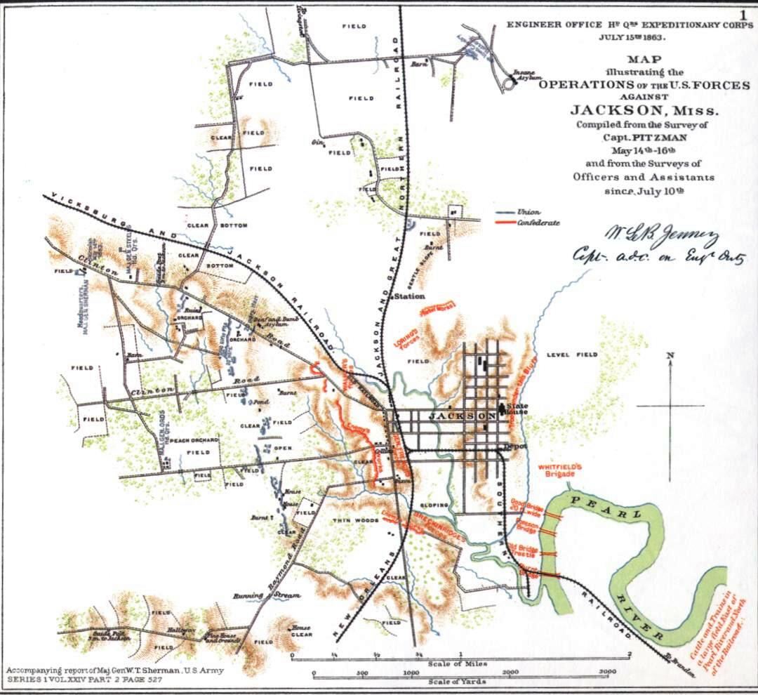
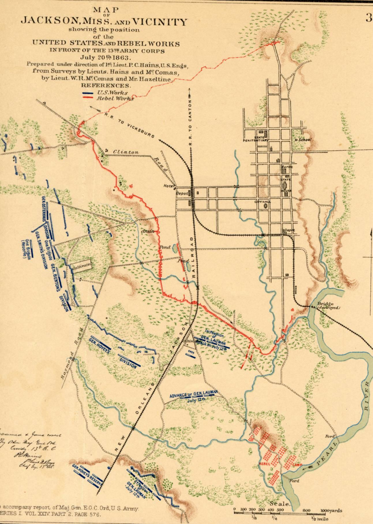
 Battle of Jackson 1863
— 303K.
Shows positions in color of Confederate and Union defenses in the Jackson area on July 20, 1863. From PLATE XXXVII – map 3 of the Atlas to Accompany the Official Records of the Union and Confederate Armies 1861-1865. Original at Choctaw Books, Jackson, MS.
Battle of Jackson 1863
— 303K.
Shows positions in color of Confederate and Union defenses in the Jackson area on July 20, 1863. From PLATE XXXVII – map 3 of the Atlas to Accompany the Official Records of the Union and Confederate Armies 1861-1865. Original at Choctaw Books, Jackson, MS.
 Battle of Jackson 1863 — 131K.
“Map illustrating the operations of the U. S. forces against Jackson, Miss.”
A little different from the previous
one . From PLATE XXXIX – map 1 of the Atlas to Accompany the Official Records of the Union and Confederate Armies 1861-1865. Courtesy of L. Graham Hughes.
Battle of Jackson 1863 — 131K.
“Map illustrating the operations of the U. S. forces against Jackson, Miss.”
A little different from the previous
one . From PLATE XXXIX – map 1 of the Atlas to Accompany the Official Records of the Union and Confederate Armies 1861-1865. Courtesy of L. Graham Hughes.
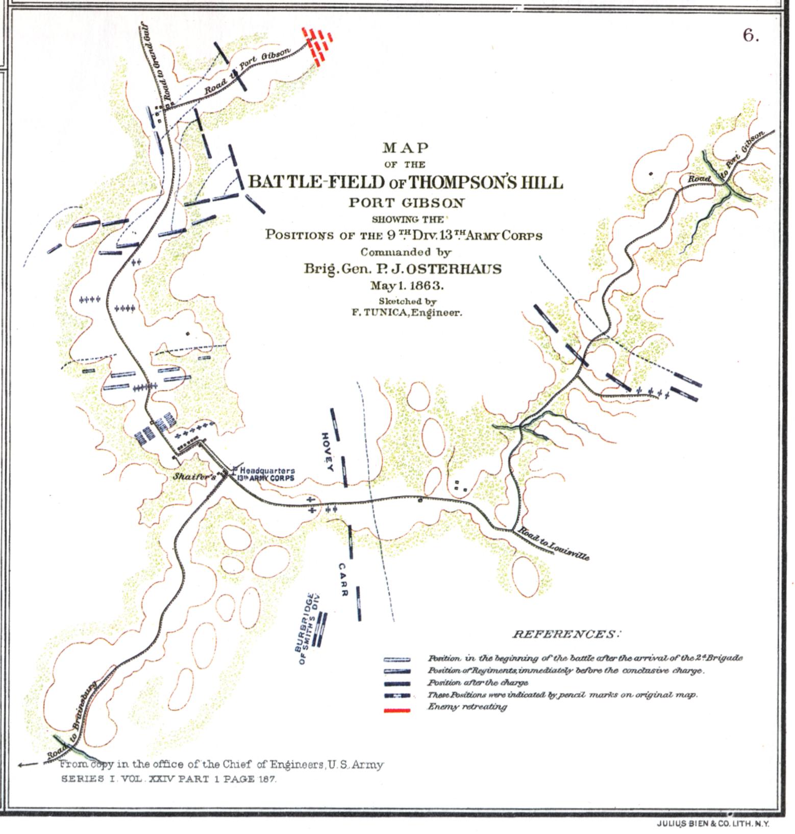 Battle of Port Gibson
— 216K.
Shows positions in color of Confederate and Union defenses in the Battlefield of Thompson’s Hill on May 1, 1863. From PLATE XXXI – map 6 of the Atlas to Accompany the Official Records of the Union and Confederate Armies 1861-1865. Courtesy of L. Graham Hughes.
Battle of Port Gibson
— 216K.
Shows positions in color of Confederate and Union defenses in the Battlefield of Thompson’s Hill on May 1, 1863. From PLATE XXXI – map 6 of the Atlas to Accompany the Official Records of the Union and Confederate Armies 1861-1865. Courtesy of L. Graham Hughes.
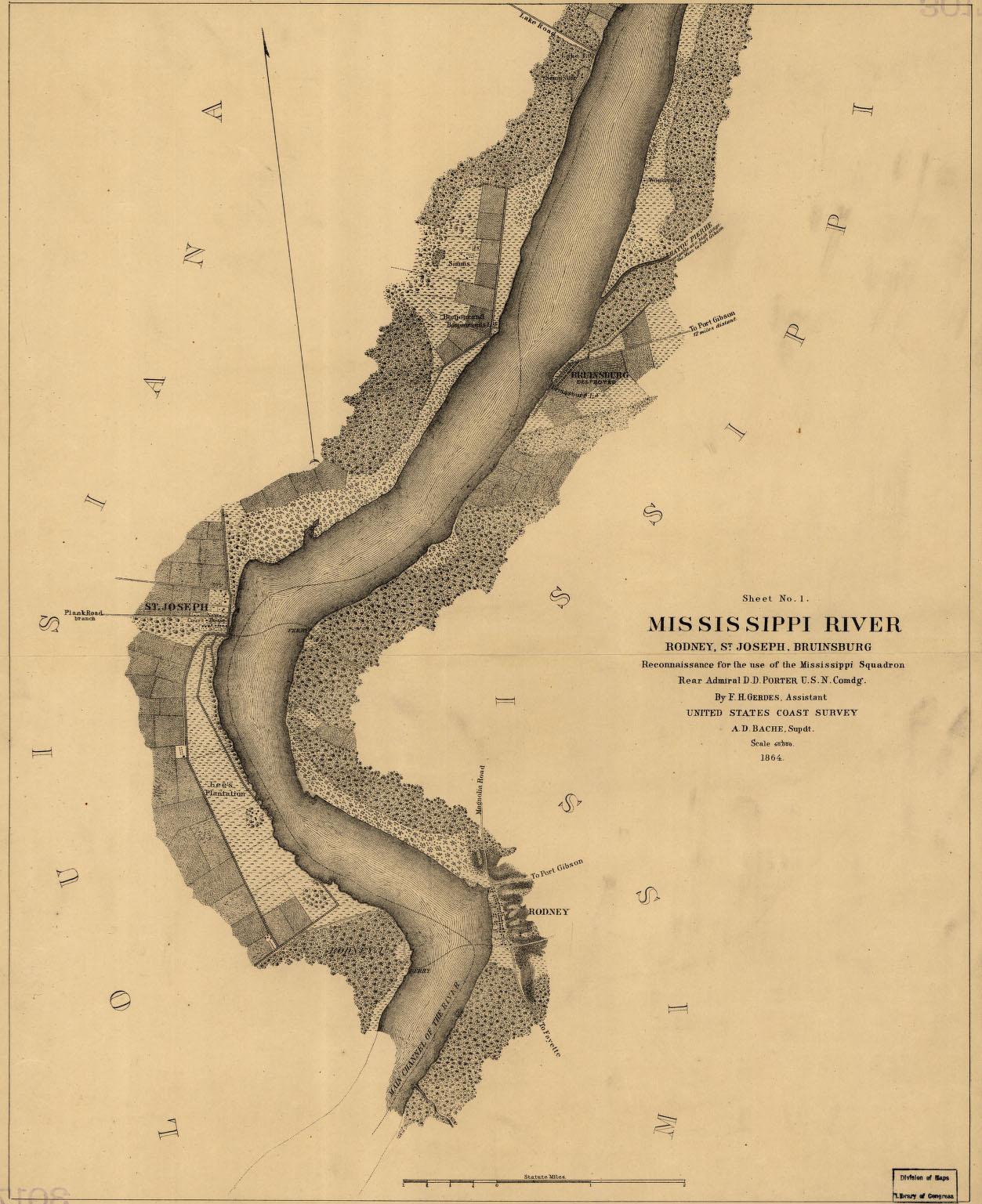 Bruinsburg, Rodney & St. Joseph areas 1864 — 287K.
Map of general area where Grant crossed the Mississippi on his way to Vicksburg. Shows some landowners. From Library of Congress.
Bruinsburg, Rodney & St. Joseph areas 1864 — 287K.
Map of general area where Grant crossed the Mississippi on his way to Vicksburg. Shows some landowners. From Library of Congress.
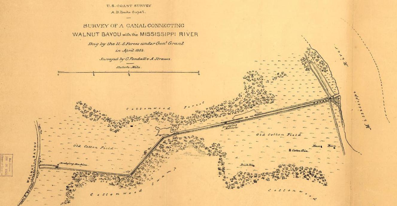 Duckport Canal 1863
— 127K.
From Library of Congress. In Grant’s attempt to bypass Vicksburg, a 40’ wide by 7’ deep canal was dug from Duckport, LA on the Mississippi River westward to Walnut Bayou. Several streams later, river traffic could theoretically reenter the Mississippi at New Carthage, LA – some 37 water miles downstream. This plan failed as did Grant’s other plans to divert the River. See also Civil War Canals in Madison Parish.
Duckport Canal 1863
— 127K.
From Library of Congress. In Grant’s attempt to bypass Vicksburg, a 40’ wide by 7’ deep canal was dug from Duckport, LA on the Mississippi River westward to Walnut Bayou. Several streams later, river traffic could theoretically reenter the Mississippi at New Carthage, LA – some 37 water miles downstream. This plan failed as did Grant’s other plans to divert the River. See also Civil War Canals in Madison Parish.
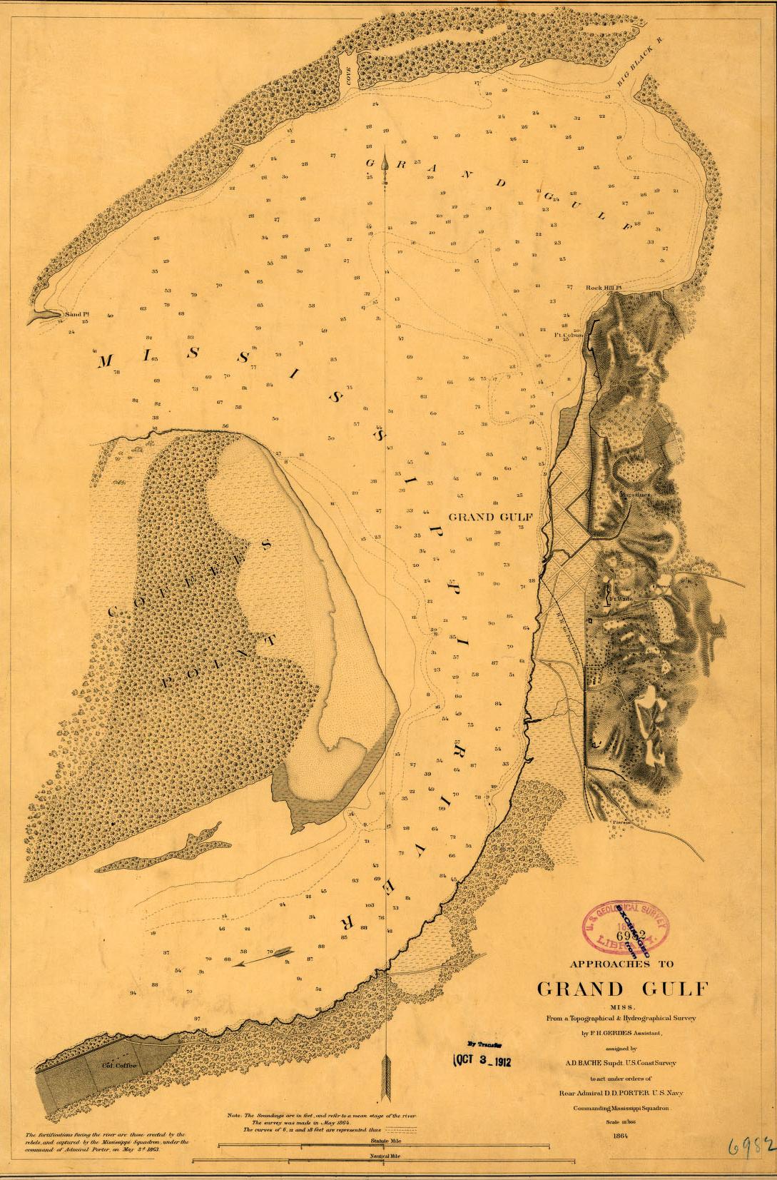
 Grand Gulf 1864
— 343K
Detailed map of the approaches to Grand Gulf. From Library of Congress
Grand Gulf 1864
— 343K
Detailed map of the approaches to Grand Gulf. From Library of Congress
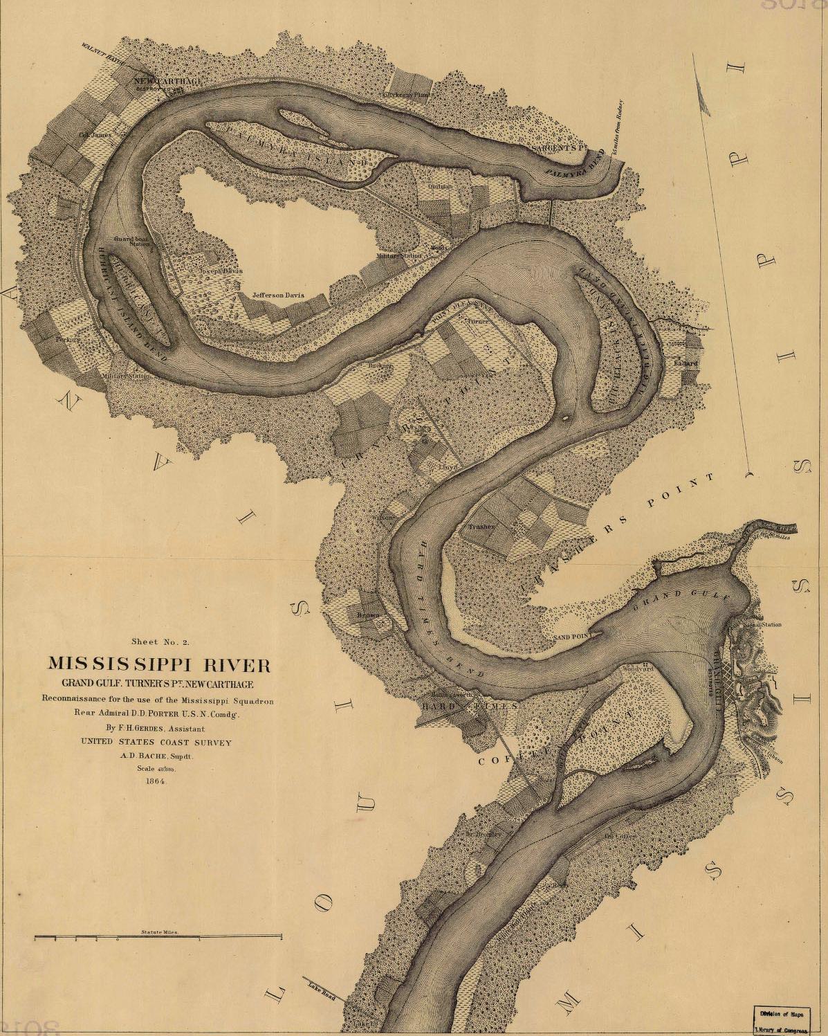
 Grand Gulf, Turner’s Point & New Carthage areas
— 425K.
Fairly
detailed map of general areas where Grant crossed the Mississippi on his way to Vicksburg. Shows some landowners including Joseph and Jefferson Davis. From Library of Congress.
Grand Gulf, Turner’s Point & New Carthage areas
— 425K.
Fairly
detailed map of general areas where Grant crossed the Mississippi on his way to Vicksburg. Shows some landowners including Joseph and Jefferson Davis. From Library of Congress.
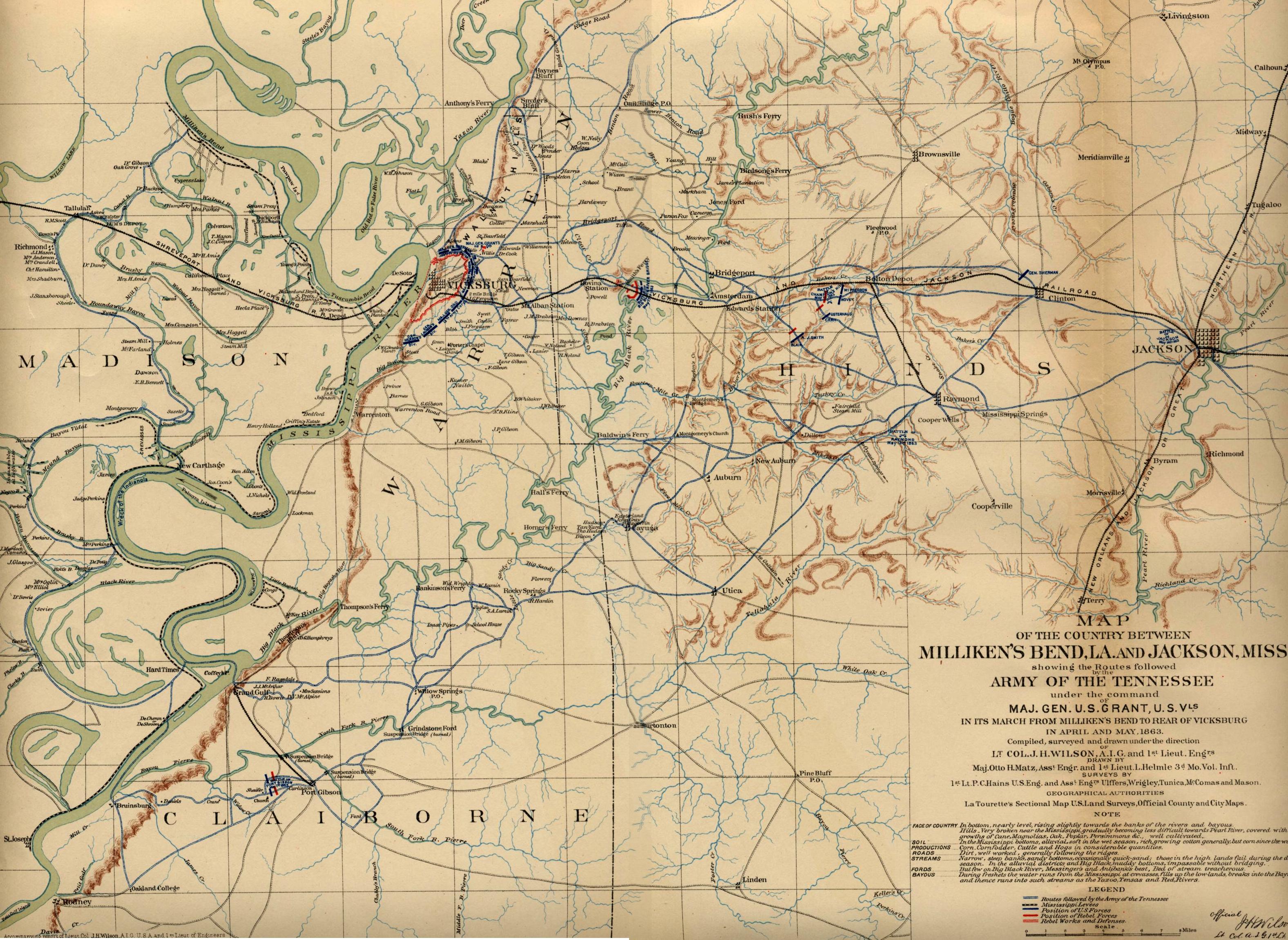
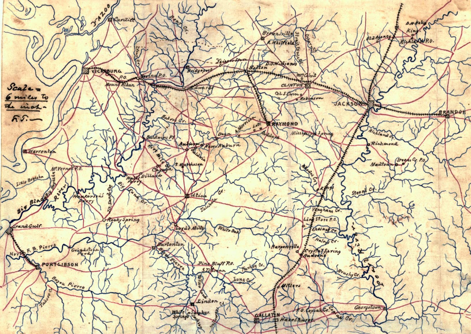
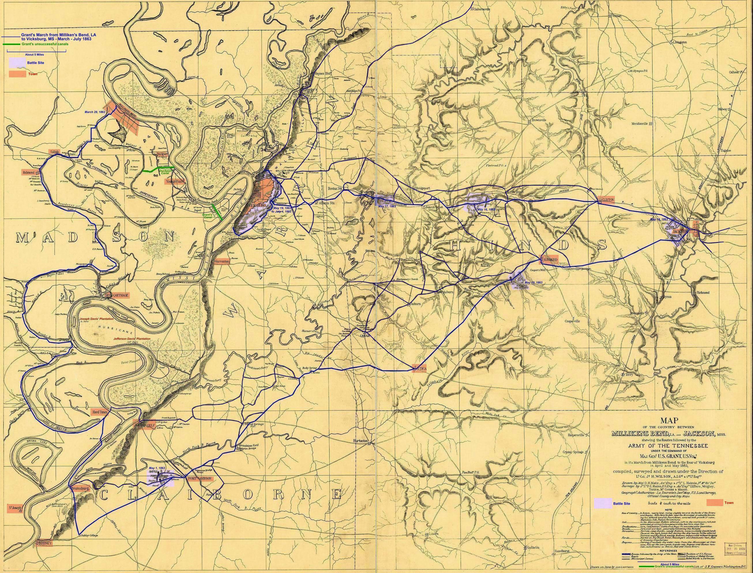 Grant's March to Vicksburg 1863
— 1,323K.
Modified from Detailed U. S. Army Map of the Country between Milliken’s Bend, LA and Jackson, MS Showing the Routes Followed by the Army of Tennessee Under the Command of Maj. Gen. U. S. Grant. Similar to and apparently a prototype of map below but different enough to be included -- more primitive and apparently made earlier.
From Library of Congress.
Grant's March to Vicksburg 1863
— 1,323K.
Modified from Detailed U. S. Army Map of the Country between Milliken’s Bend, LA and Jackson, MS Showing the Routes Followed by the Army of Tennessee Under the Command of Maj. Gen. U. S. Grant. Similar to and apparently a prototype of map below but different enough to be included -- more primitive and apparently made earlier.
From Library of Congress.
 Grant's March to Vicksburg 1863 —1,267K – Similar to map above.
map 1 of the Atlas to Accompany the Official Records of the Union and Confederate Armies 1861-1865. Original at Choctaw Books, Jackson, MS.
Grant's March to Vicksburg 1863 —1,267K – Similar to map above.
map 1 of the Atlas to Accompany the Official Records of the Union and Confederate Armies 1861-1865. Original at Choctaw Books, Jackson, MS.
 Grierson's March to Baton Rouge 1863 —188K
Griersons March from Lagrange, TN to Baton Rouge. From Library of Congress.
Grierson's March to Baton Rouge 1863 —188K
Griersons March from Lagrange, TN to Baton Rouge. From Library of Congress.
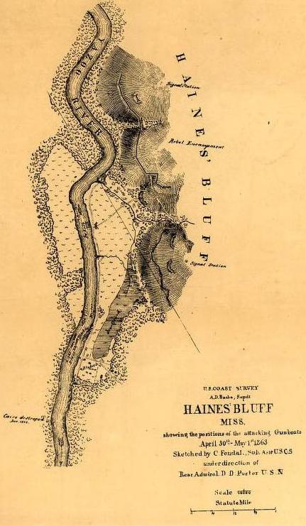 Haines Bluff 1863
— 68K.
Shows positions on the Yazoo River just north of Vicksburg of the attacking gunboats April 30th and May 1st 1863. From Library of Congress.
Haines Bluff 1863
— 68K.
Shows positions on the Yazoo River just north of Vicksburg of the attacking gunboats April 30th and May 1st 1863. From Library of Congress.
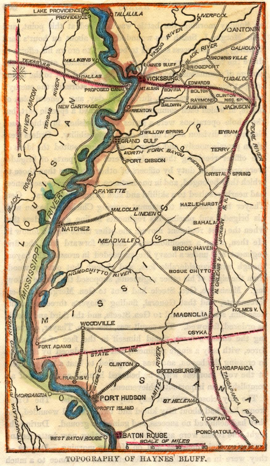
 ”Haynes” Bluff Topography 1865
— 271K.
Although entitled “Topography of Haynes Bluff”, the color map shows an area from just north of Vicksburg to Baton Rouge with all towns, roads and railroads in between. By Waters-Son SC, NY. Original at Choctaw Books, Jackson, MS.
”Haynes” Bluff Topography 1865
— 271K.
Although entitled “Topography of Haynes Bluff”, the color map shows an area from just north of Vicksburg to Baton Rouge with all towns, roads and railroads in between. By Waters-Son SC, NY. Original at Choctaw Books, Jackson, MS.
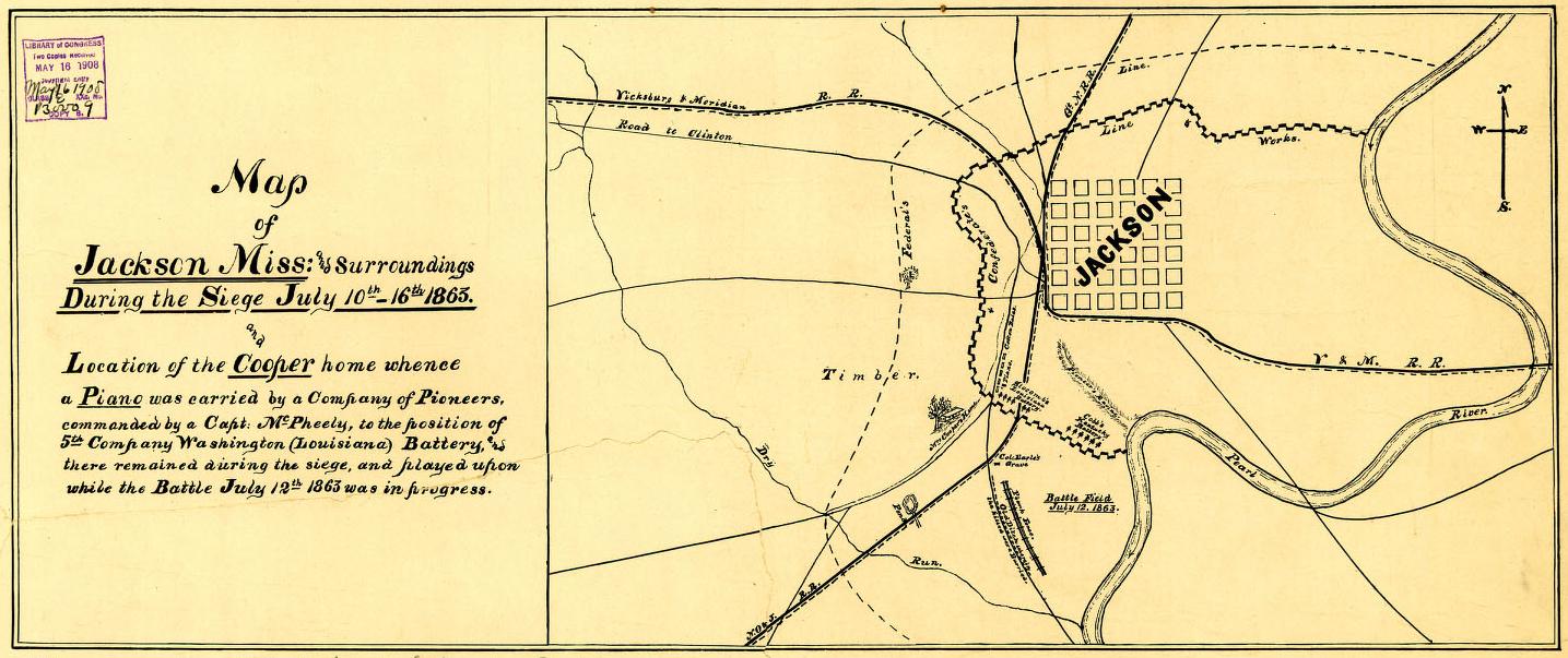
 Jackson 1863
— 156K.
Shows Jackson and surroundings during siege of July 10 to 16, 1863. From Library of Congress.
Jackson 1863
— 156K.
Shows Jackson and surroundings during siege of July 10 to 16, 1863. From Library of Congress.
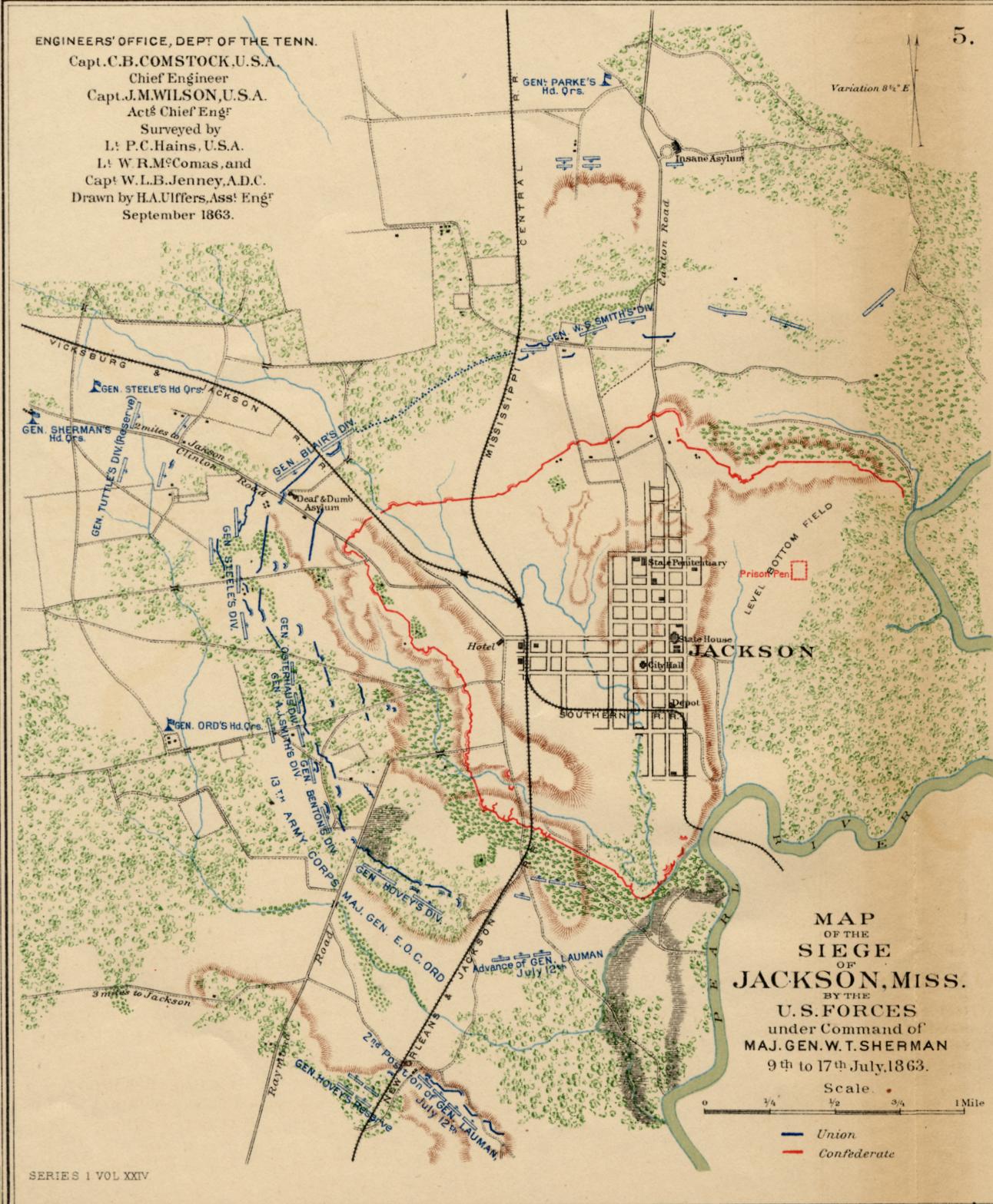 Jackson Siege 1863
— 324K.
Shows
military positions in color during the Siege of Jackson from July 9 through 17, 1863. From PLATE XXXVII – map 2 of the Atlas to Accompany the Official Records of the Union and Confederate Armies 1861-1865. Original at Choctaw Books, Jackson, MS.
Jackson Siege 1863
— 324K.
Shows
military positions in color during the Siege of Jackson from July 9 through 17, 1863. From PLATE XXXVII – map 2 of the Atlas to Accompany the Official Records of the Union and Confederate Armies 1861-1865. Original at Choctaw Books, Jackson, MS.
 Natchez 1864
— 275K.
Map of the
Defences (sic) of Natchez and vicinity. From Library of Congress.
Natchez 1864
— 275K.
Map of the
Defences (sic) of Natchez and vicinity. From Library of Congress.
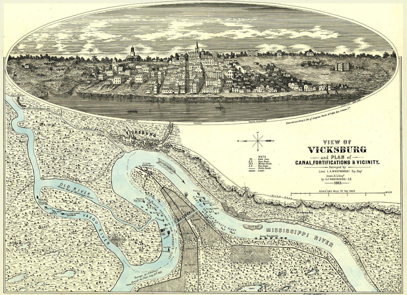
 Vicksburg 1863 — 672K.
Panorama of Vicksburg plus a map of the Mississippi River showing positions of gun boats, rebel guns, fortifications, proposed canal, etc. in 1862. From Library of Congress.
Vicksburg 1863 — 672K.
Panorama of Vicksburg plus a map of the Mississippi River showing positions of gun boats, rebel guns, fortifications, proposed canal, etc. in 1862. From Library of Congress.
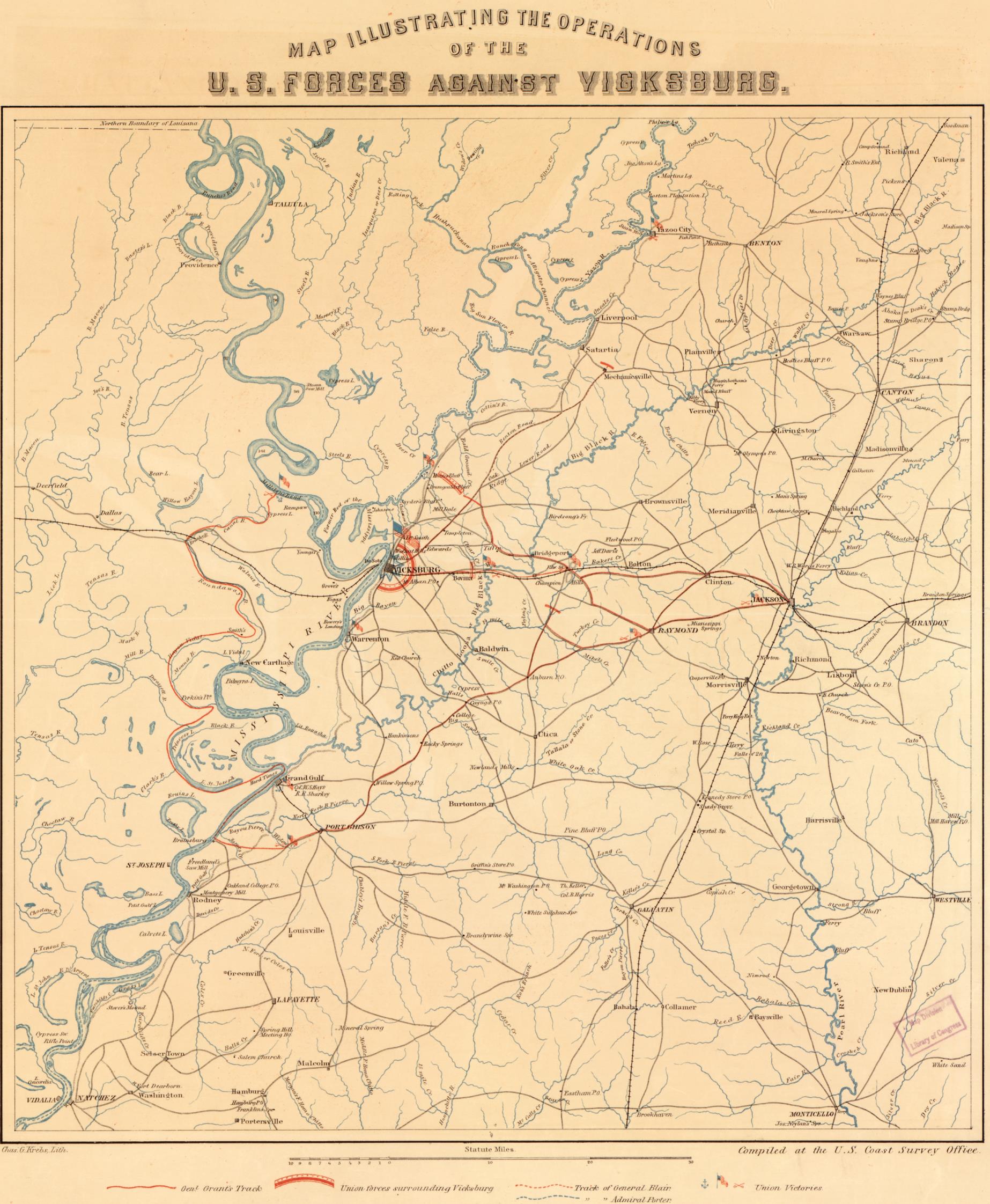 Vicksburg Area 1863
— 583K. Map illustrating the operations of U.S. Forces against Vicksburg / compiled at the U.S. Coast Survey Office; J.W. Maedel.
From Library of Congress.
Vicksburg Area 1863
— 583K. Map illustrating the operations of U.S. Forces against Vicksburg / compiled at the U.S. Coast Survey Office; J.W. Maedel.
From Library of Congress.
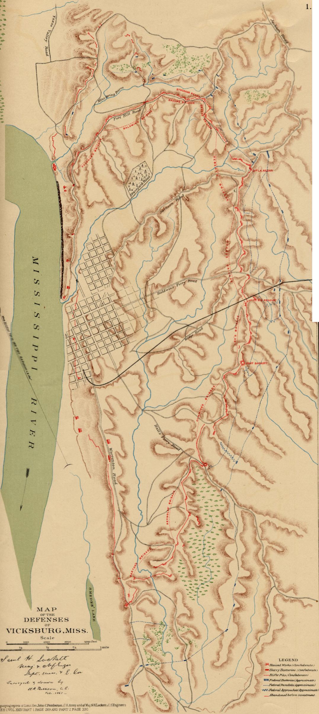
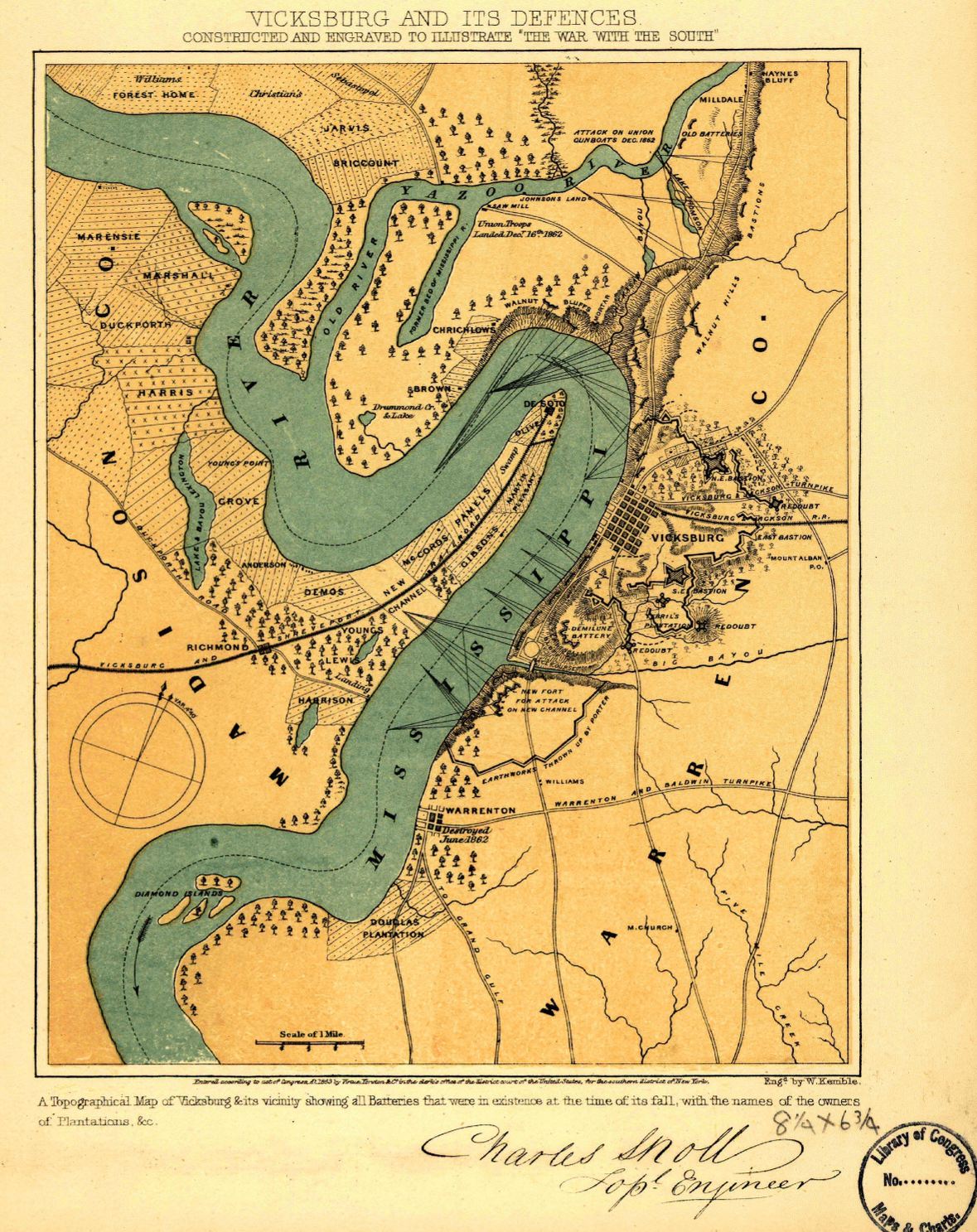
 Vicksburg and its “Defences” 1863
— 434K.
Shows all batteries in force at the time of surrender;
also plantation names, especially in Madison Parish, LA. From Library of Congress.
Vicksburg and its “Defences” 1863
— 434K.
Shows all batteries in force at the time of surrender;
also plantation names, especially in Madison Parish, LA. From Library of Congress.
 Vicksburg and its Defenses 1863
— 384K.
Large-scale color map of the locations and types of Confederate defense positions. From PLATE XXXVII – map 1 of the Atlas to Accompany the Official Records of the Union and Confederate Armies 1861-1865. Original at Choctaw Books, Jackson, MS.
Vicksburg and its Defenses 1863
— 384K.
Large-scale color map of the locations and types of Confederate defense positions. From PLATE XXXVII – map 1 of the Atlas to Accompany the Official Records of the Union and Confederate Armies 1861-1865. Original at Choctaw Books, Jackson, MS.
 Vicksburg 1863
— 304K.
Hand-colored map showing property owners and "The Rebel Position at Vicksburg, Miss., May 1863. From Library of Congress.
Vicksburg 1863
— 304K.
Hand-colored map showing property owners and "The Rebel Position at Vicksburg, Miss., May 1863. From Library of Congress.
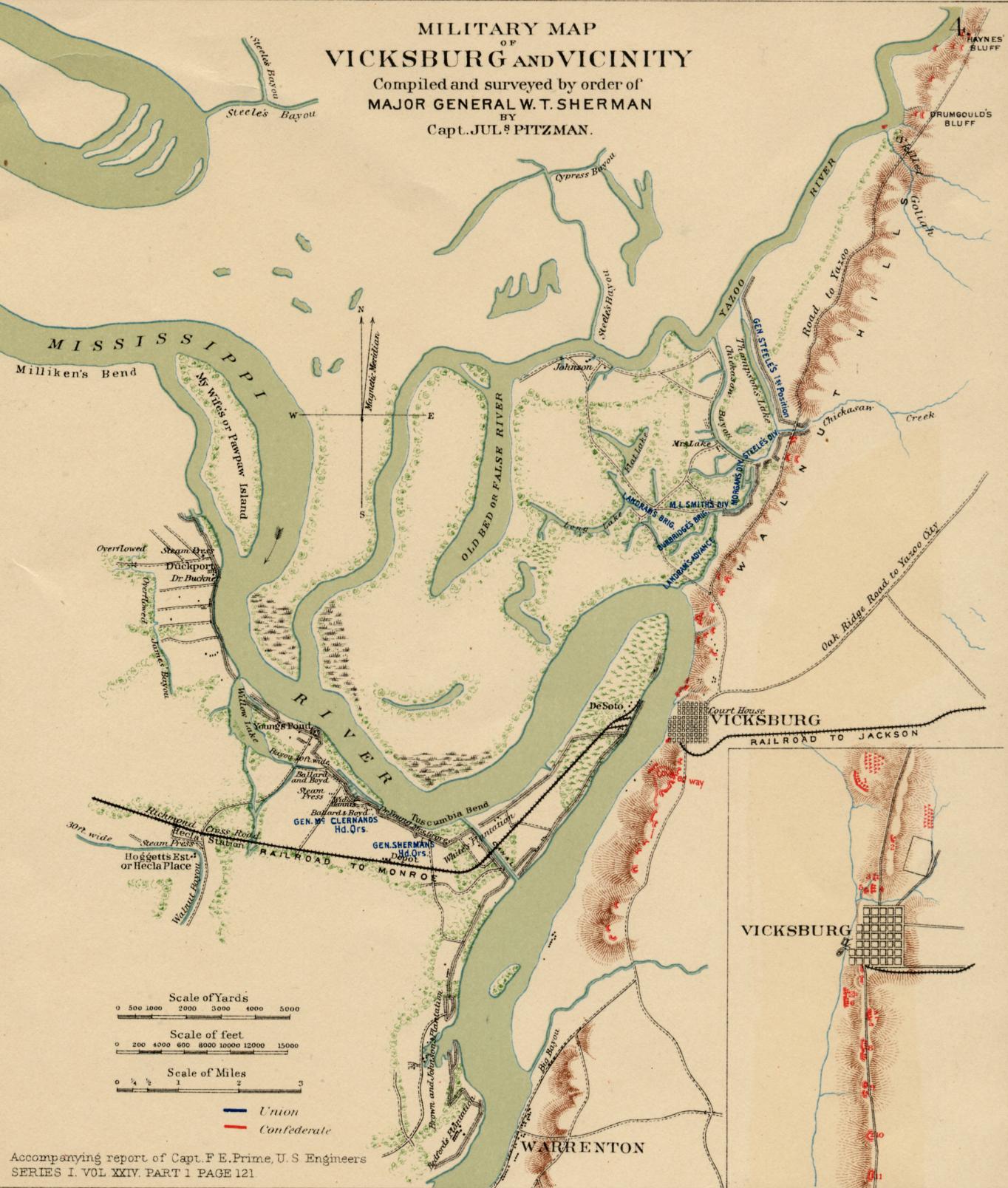
 Vicksburg and Vicinity 1863
— 703K.
From Milliken’s Bend, LA to Port Gibson, MS. “NEW MAP of VICKSBURG, showing the Scene of General Grants Operations, Together with all of the Fortifications, Rifle Pits, &c.” Includes quite a bit of narrative. G. W. Tomlinson, Publisher. Boston. From Library of Congress.
Vicksburg and Vicinity 1863
— 703K.
From Milliken’s Bend, LA to Port Gibson, MS. “NEW MAP of VICKSBURG, showing the Scene of General Grants Operations, Together with all of the Fortifications, Rifle Pits, &c.” Includes quite a bit of narrative. G. W. Tomlinson, Publisher. Boston. From Library of Congress.
 Vicksburg – Military Map 1863
— 286K.
Color map of Vicksburg and vicinity
made by order of major general W. T. Sherman. From PLATE XXXVII – map 4 of the Atlas to Accompany the Official Records of the Union and Confederate Armies 1861-1865. Original at Choctaw Books, Jackson, MS.
Vicksburg – Military Map 1863
— 286K.
Color map of Vicksburg and vicinity
made by order of major general W. T. Sherman. From PLATE XXXVII – map 4 of the Atlas to Accompany the Official Records of the Union and Confederate Armies 1861-1865. Original at Choctaw Books, Jackson, MS.
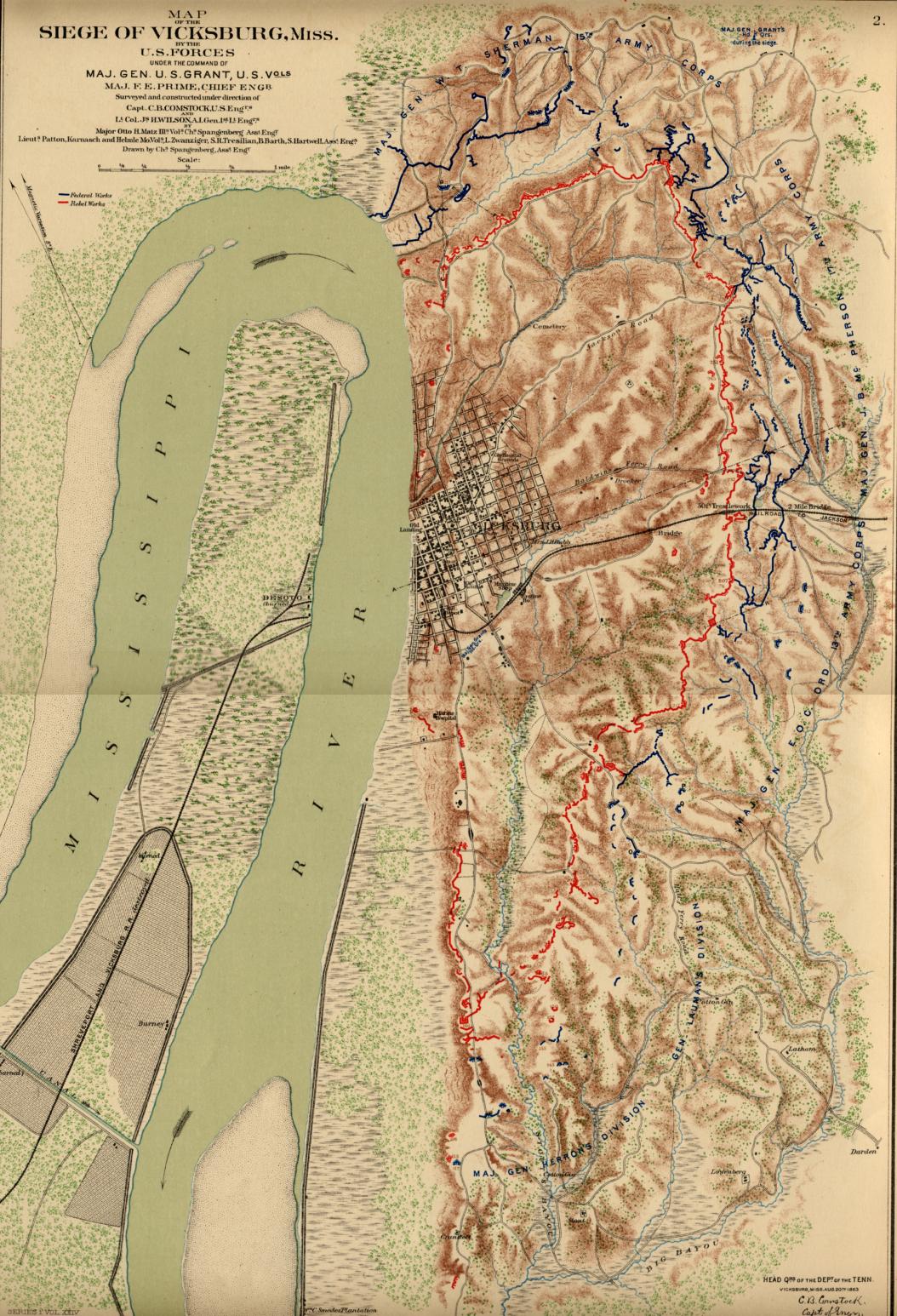 Vicksburg - Siege — 360K.
Shows Vicksburg during siege, including Confederate and Union positions.
A color map from PLATE XXXVI – map 2 of the Atlas to Accompany the Official Records of the Union and Confederate Armies 1861-1865. Original at Choctaw Books, Jackson, MS.
Vicksburg - Siege — 360K.
Shows Vicksburg during siege, including Confederate and Union positions.
A color map from PLATE XXXVI – map 2 of the Atlas to Accompany the Official Records of the Union and Confederate Armies 1861-1865. Original at Choctaw Books, Jackson, MS.
 Vicksburg - Jackson 1863 — 469K. Map of the environs of Vicksburg and Jackson, Mississippi.
Shows towns, railroads, roads, drainage and some landowners.
From Library of Congress.
Vicksburg - Jackson 1863 — 469K. Map of the environs of Vicksburg and Jackson, Mississippi.
Shows towns, railroads, roads, drainage and some landowners.
From Library of Congress.
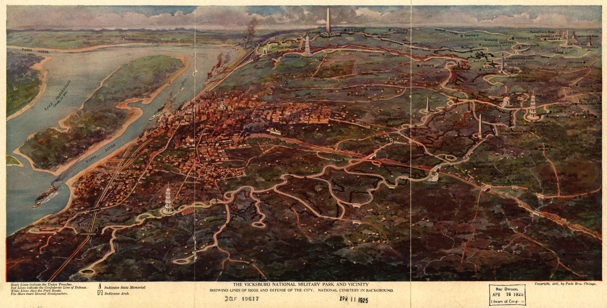 Vicksburg National Park 1925
— 538K.
"The Vicksburg National Park and Vicinity showing Lines of Siege and Defense of the City."
From Library of Congress.
Vicksburg National Park 1925
— 538K.
"The Vicksburg National Park and Vicinity showing Lines of Siege and Defense of the City."
From Library of Congress.
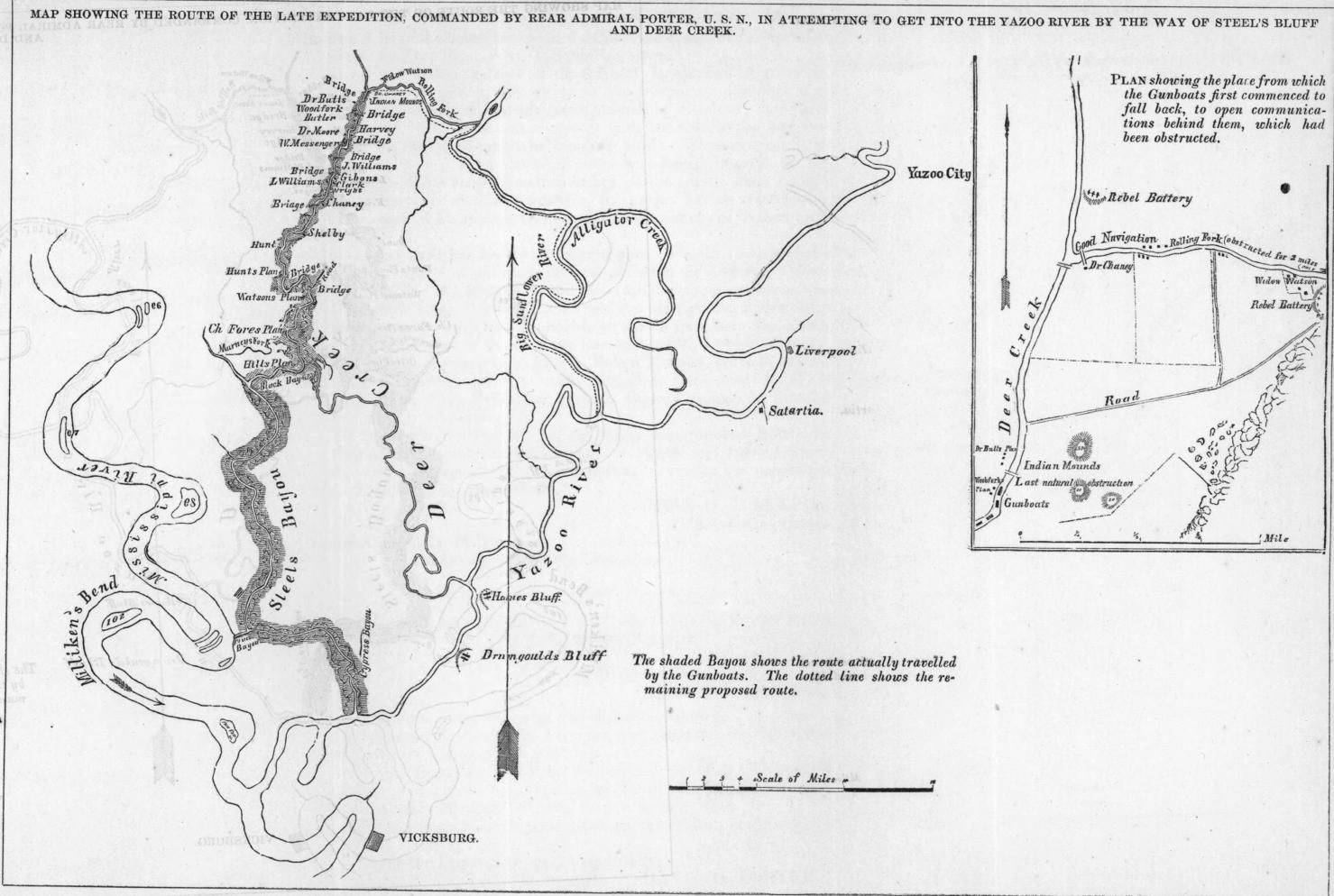 Yazoo River 1863
— 177K.
Map showing route of Rear Admiral Porter's attempt to get into the Yazoo River by way of Steel's Bluff and Deer Creek.
From Library of Congress.
Yazoo River 1863
— 177K.
Map showing route of Rear Admiral Porter's attempt to get into the Yazoo River by way of Steel's Bluff and Deer Creek.
From Library of Congress.
USGS Topographic maps for Mississippi are available by clicking here, selecting a “Cell Name”, then right-clicking the corresponding “TIFF” image and selecting “Save Target as...” Save and rename file to any location desired. The map file will then be downloaded to the selected location where it can be viewed and manipulated with almost any imaging program. Note that these TIFF files are very large, from 2 to 10 megabytes, but can be made smaller by resizing after the download.
The
two maps below show the geographic distribution of those who viewed the
Mississippi Digital Map Library during the months of July 2013 through June 2014. In
this one year period
there has been a total of 7,458 viewers from 1,732 different cities - 1,556 in the United
States and 176 foreign. A total of 54 foreign countries are represented.
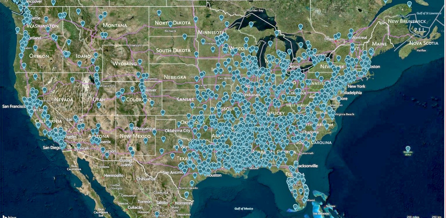
United States Viewers July 2013 thru June 2014 (Map made using Mapcite)
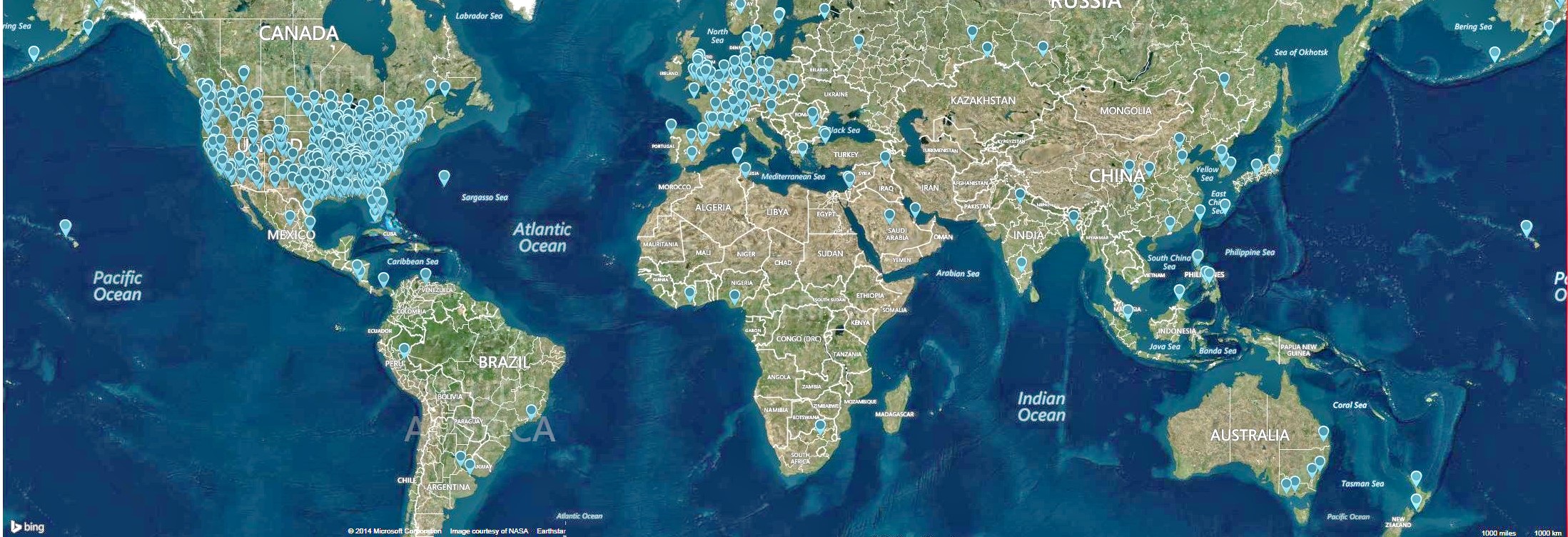
World Viewers July 2013 thru June 2014 (Map made using Mapcite)
![]()
Copyright © 1999 - USGenWeb Archives Map Project