
These pages are dedicated to
Donald Leroy Spidell
1942~1999
|
State and
County Maps
United States Maps
Indian Land Cessions
to the United States
Treaty Maps
STATE MAP COORDINATORS
The United States Digital Map Library is a USGenWeb Archives project, developed in April of 1999 under the coordination of Fred Smoot. The current Coordinator is Deb Haines. Please don’t hesitate to contact me if you have any questions or comments. The goal of this project is to make available to genealogists, useful, readable, high quality maps.
This project and its all-volunteer staff are dedicated to free, online access for the general public. We rely on contributions and volunteers. If you would like to be a part of our team, please see our State Map Coodinator Page. If you would like to contribute a map, see Submissions. If you have questions about our copyright policy, please visit the Copyright Page.
Our map graphics require long download times because the file sizes are quite large. Although they are normally around 500k, they can run as high as 1.5 megs. If you are having problems downloading maps, please see Map Advice.
Use of These Maps
You have permission to use any pre-1923 map graphic. Works that carry a visible copyright of others may not be used outside the USGenWeb Archives, United States Digital Map Library, or the USGenWeb Project without the express permission of those copyright holders.
Old Maps
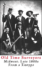 Old maps often contain information that will help locate towns that no longer exist, or old landmark names that aren’t used anymore. Some good early maps can be valuable to genealogists in finding these long forgotten places. Unfortunately, good early maps are hard to come by —and aren’t inexpensive. Early cartographers relied on surveys which were not always accurate. This resulted in mistakes on early maps (for example, California is often depicted as an island). From our colonial times, up until about 1915, basic surveying was taught as a normal part of the mathematics curriculum up until about the eighth or ninth grade. The best of surveyors were then know as mathematicians but there were certainly many surveyors that barely qualified back then, and definitely would not qualify by today's standards. The surveying tools, originally made in Europe, finally began to be made here in the United States and by the 1850s, our American-made tools of trade were up to European standards. Interestingly, the first survey made in California was made with nautical instruments. It is after the 1850s that our surveying really made giant leaps forward. Better maps came with the better surveys. Up to the Civil War, really good county maps were very scarce. During that war, both sides were plagued with poor quality maps. Today, we have the excellent USGS maps to rely upon, and those maps should be part genealogists reference materials. Old maps often contain information that will help locate towns that no longer exist, or old landmark names that aren’t used anymore. Some good early maps can be valuable to genealogists in finding these long forgotten places. Unfortunately, good early maps are hard to come by —and aren’t inexpensive. Early cartographers relied on surveys which were not always accurate. This resulted in mistakes on early maps (for example, California is often depicted as an island). From our colonial times, up until about 1915, basic surveying was taught as a normal part of the mathematics curriculum up until about the eighth or ninth grade. The best of surveyors were then know as mathematicians but there were certainly many surveyors that barely qualified back then, and definitely would not qualify by today's standards. The surveying tools, originally made in Europe, finally began to be made here in the United States and by the 1850s, our American-made tools of trade were up to European standards. Interestingly, the first survey made in California was made with nautical instruments. It is after the 1850s that our surveying really made giant leaps forward. Better maps came with the better surveys. Up to the Civil War, really good county maps were very scarce. During that war, both sides were plagued with poor quality maps. Today, we have the excellent USGS maps to rely upon, and those maps should be part genealogists reference materials.
Please remember that not all old maps will qualify for inclusion in this project. Some modern made maps might better qualify.
USGenWeb Archives
Linda Russell Lewis
Coordinator
Joy Fisher
Assistant Coordinator


This page was first posted on:
30 April 1999
© Copyright 1999-2008 USGenWeb Archives
|