REPORT OF THE COMMISSION TO LOCATE THE SITE OF THE FRONTIER FORTS OF PENNSYLVANIA.
VOLUME TWO.
CLARENCE M. BUSCH.
STATE PRINTER OF PENNSYLVANIA.
1896.
FRONTIER FORTS OF WESTERN PENNSYLVANIA.
By George Dallas Albert.
BEAVER COUNTY.
Pages 485-509.
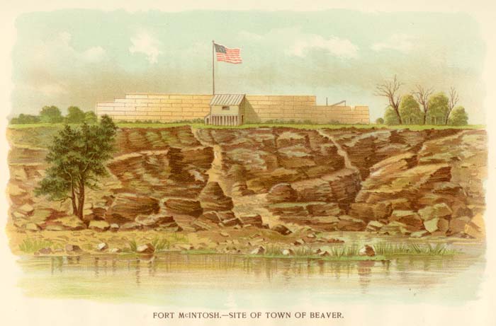
FORT MCINTOSH.
Fort McIntosh. - Site of Town of Beaver.
From the barbarous warfare carried on against the western frontier by the British under Henry Hamilton, their Governor of Detroit, with the assistance of the Indian tribes who had taken part with them, it was determined by the Commissioners of Congress, who met in Pittsburgh late in 1777, that the permanent safety of this section could be secured only by carrying on a successful war, in an aggressive manner, against the enemy in their own country. This, for some time, had been the plan uppermost in the mind of Washington. When Gen. Hand was recalled at his own request from the command of the Western Department, the Commander-in-Chief designated Gen. Lachlin McIntosh to succeed him. (1.)
On the 26th of May, 1778, McIntosh was notified of his appointment, but, owing to delay necessarily occasioned, he did not arrive in Pittsburgh till early in August.
The Fort Pitt Commissioners had advised that the expedition which they concluded to recommend against Detroit should march from Pittsburgh by the first of September, (1778); but as it was found before that time to be impossible to do so, Congress resolved that the expedition, for the present, should be deferred.
McIntosh, however, was directed to assemble at Pittsburgh one thousand five hundred continental troops and militia, and proceed without delay to destroy such towns of the hostile tribes as he, in his discretion, should think would most effectually tend to chastise and check the savages on the western frontier. (2.) But notwithstanding these direct orders. McIntosh had his eye on Detroit, and was led to believe that he could, as the occasion offered, penetrate successfully to that post and capture it with the forces available. The event showed, however, that his means were inadequate to such a daring campaign.
When McIntosh arrived in the Western Department—about the 6th of Aug.—there were but two fixed stations, besides Fort Pitt, west of the Alleghenies, occupied by Continental troops. These two were Fort Randolph, (Wheeling), and Fort Hand. The latter was a small stockaded structure on the southern bank of the Kiskiminetas, on the frontier north of Pittsburgh. There were, however, 30 or 40 other smaller stations, or forts, scattered throughout this region, some between Wheeling and Pittsburgh; others upon the waters of, the Monongahela, and still others along the northern frontier from the Kiskiminetas to Fort Ligonier. These at different times were garrisoned by militia or defended by volunteer rangers. They were frequently altered, kept, or evacuated, according to the humors, fears, or interests of the people of most influence. Gen. Hand had been obliged to yield to this condition, as his chief dependence was on militia. These forts, in view of the fact that they were very expensive and would be of little service now that the war was to be carried into the enemy's country, McIntosh resolved to break up as soon as he could, without giving too much offence to the people, whose assistance he so much required.
That the frontiers might not be wholly deprived of means of defence while the army marched into the Indian country, the Lieutenants of Monongalia and Ohio counties, Virginia, (3), were authorized to raise a ranging company jointly, to scout continuously along the Ohio river from Beaver creek downward, where the savages usually crossed to annoy the settlements. Archibald Lochry, Lieut. of Westmoreland co., Penna., was empowered to organize two such companies, to scour the frontiers on the north, as a protection from scalping parties of the northern Indians. Independent companies had been raised for the sole purpose of maintaining Fort Pitt, Fort Hand and Fort Randolph, as these posts were expected soon to be evacuated by their garrisons.
Mcintosh had not been long in the west when he discovered that a number of storehouses for provisions, which had been built at public expense, were at great distances apart, difficult of access, and scattered throughout the border counties. At each of these, a number of men were required. These buildings were given up, as the provisions in them intended for the expedition proved to be spoiled. In place of them, one general store house was built by a fatigue party, "in the fork of the Monongahela river," where all loads from over the mountains could be discharged, without crossing any considerable branch of any river.
The Commissioners at Fort Pitt proposed to Congress that a treaty be held on the 23d of July, at Pittsburgh, with the Delawares, Shawanese and other Indians. Congress approved this suggestion, and resolved that three persons should be appointed to negotiate with the savages. Virginia was requested to send two and Pennsylvania one commissioner for that purpose. Messengers carrying presents had already been dispatched to the Delawares and Shawanese, with invitations to attend the conference. Two Virginians, representing The United States, repaired to Fort Pitt, but Pennsylvania neglected to send a representative. This caused some disappointment. From the wilderness across the Ohio, no Indians came but Delawares, as a large majority of the Shawanese were now openly hostile to The United States. The former tribe was represented by their three principal chiefs. It was September before the parties met for consultation; and a treaty was not finally signed until the 17th of that month. By its terms, not only were the Delawares made close allies of The United States and "the hatchet put into their hands,"—thus changing and wisely too the neutral policy previously acted upon,—but consent was obtained for marching the army across their territory. They stipulated to join the troops of the general government with such a number of their best and most expert warriors as they could spare, consistent with their own safety. A requisition for two captains and 60 braves was afterward made upon the nation by the American commander.
The neutrality of the Delawares having thus, for the present, been assured by the treaty at Fort Pitt, on the 17th of Sept., (1778), as above referred to, Mcintosh was thereupon ordered to move westward. He descended the Ohio with a force of regulars and militia, in the month of Oct., to the mouth of the Beaver, a northern tributary of the Ohio, where, on the present site of the town of Beaver, about 30 miles below Pittsburgh, he erected a fort which was called, in honor of the projector, Fort McIntosh.
In a letter to Vice-President Bryan, written from Fort Pitt on the 29th of Dec., 1778, (4), Gen. McIntosh speaks of this fort as follows:
"Notwithstanding the season was so late that we could not get a sufficiency of supplies, and the men so tedious before they came and joined me, with many other difficulties I had to encounter, I erected a good, strong fort for the reception and security of prisoners and stores upon the Indian side of the Ohio, below Beaver creek, with barracks for a regiment; and another upon Muskingum river, where Colonel Bouquet had one formerly, near Tuscarawas, about 100 miles from this place, which I expect will keep the savages in awe, and secure the peace of the frontiers effectually in this quarter hereafter, if they are well supplied; and will also facilitate any further enterprises that may be attempted that way." (5.)
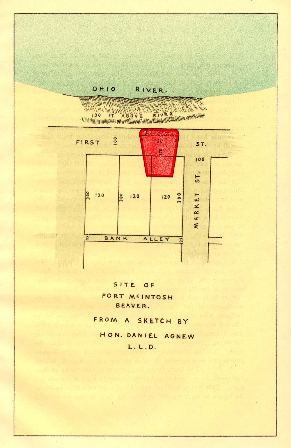
Site of Fort McIntosh, Beaver.
The fort was built under the immediate supervision of a military engineer named Le Chevalier de Cambray. The structure was not large, but was built of strong stockades, and furnished with bastions, mounting one six-pounder each. It was the first military post of The United States established beyond the frontier settlements, upon the Indian side of the Ohio. The timbers were of hewn logs; its figure was an irregular square, the face to the river being longer than the side to the land. It was about equal to a square of 50 yards; was well built, and strong against musketry.
As early as the 8th of October, the headquarters of the army were removed from Fort Pitt to the new fort, (7) where a considerable force—the largest collected west of the Alleghenies during the Revolution (8)—was assembled, consisting, besides the continental troops, of militia, mostly from the western counties and from Virginia. But the want of necessary sup~ plies prevented any immediate forward movement. On the third day of November, cattle from over the mountains arrived, but they were extremely poor, and could not be slaughtered for want of salt.
Alarming intelligence now reached McIntosh from the wilderness west. He was reproached for his tardiness by friendly Indians, who threatened that all their nations would unite in the Tuscarawas Valley to give him battle, and oppose his progress to Detroit. Orders were, therefore, immediately issued for 1200 men to get ready to march. On the 5th of Nov., the movement of the army westward commenced, including the whole force, except one company, which was left under command of Lieut.-Col. Richard Campbell, of the 13th Virginia regiment, to bring on the "long looked for supplies." For 14 days, the march was continued before the Tuscarawas was reached, a distance of only about 70 miles from Fort McIntosh. This slow progress was caused by the "horses and cattle tiring every four or five miles." It was upon this river, where the army had now encamped, that the commander anticipated meeting the enemy; but only a few Delawares from Coshocton and some Moravian Indians were found, and they were friendly. The gathering of the savages to impede his march, he was told, had been abandoned.
At this juncture, McIntosh was informed that the necessary supplies for the winter had not reached Fort McIntosh, and that very little could be expected. He was thus disappointed in all his "flattering prospects and schemes" against Detroit. There was now no other alternative but to return as he came, without effecting any valuable purpose, thereby confirming the savages in the opinion already formed of the weakness of the Americans, and combining them all more completely with the British,—or, to build a strong stockade fort upon the Tuscarawas, and leave as many men as provisions would justify, to secure it till the next season, to serve as a bridle upon the Indians in their own country. (9.) The commander, with the unanimous approbation of his principal officers, chose the latter alternative; and a post was commenced where there had been one formerly, on the west bank of the river, below the mouth of Sandy creek,—the whole army being employed upon it while provisions lasted; not, however, without some trouble, as the militia whose homes were west of the mountains, were in a mutinous condition. (10.)
Leaving the garrison of 150 men, with scanty supplies, under command of Col. John Gibson, to finish and protect the work, McIntosh, with the rest of his army, returned, very short of provisions, to Fort McIntosh, where the militia under his command were discharged "precipitately."
The General then made such disposition of the continental troops and independent companies for the winter as, in his judgment, would protect the border, and facilitate future operations. The Eighth Penn'a regiment was assigned to Fort Pitt. The men left at Fort Laurens, were part of the Thirteenth Virginia. The residue with the independent companies, were divided between Fort McIntosh, Fort Henry, Fort Randolph and Fort Hand, with a few at interior stations. There was not one of the militia retained under pay at either of these posts. (11.)
When tidings reached Gen. Mcintosh that Fort Laurens was besieged by the savages, and the garrison in most miserable straits, he, on the 19th of March, (1779), with about two hundred militia quickly raised from the counties west of the mountains, and over three hundred continental troops from Fort McIntosh and Fort Pitt, left the former post upon his second march to the Tuscarawas; arriving there in four days, to find the siege of Fort Laurens abandoned and the savages gone. (12.)
When Col. Brodhead was directed to take command of the Western Department as the successor of Gen. McIntosh in April, 1779, he was in command of Fort McIntosh. He immediately changed his headquarters to Fort Pitt. (13.) In a letter from Pittsburgh, April 15th, 1779, to President Reed, he says: "My regiment is at present much scattered; above 100, under Maj. Vernon, are posted at Fort Laurens; 25 at Wheeling, and the like number at Holliday's Cove, some employed as artificers, some as boatmen, wagoners, etc. The garrison at Fort McIntosh is of my regiment and some of them are here, there is such a delinquency in the staff department that their men are mostly supplied from the line."
In a postscript to a letter to Gen. Washington, dated at Fort Pitt, July 31st, 1779, he writes: (14)
"I have just learned that two soldiers have lately been killed at Fort Laurens, two boys at Wheeling creek, two boys taken on Raccoon creek, and one man slightly wounded, and a soldier last evening killed at Fort McIntosh, and a soldier slightly wounded. The soldiers are so intent on going to Kentuck and the Falls of the Ohio, I fear shall have few volunteers."
From Pittsburgh, Oct. 26, 1779, he writes to the Hon. John Jay (15) that some of the inhabitants from Youghagenia (Yohogania) and Ohio counties "have been hardy enough to cross the Ohio river and make small improvements on the Indian lands from the River Muskingum to Fort McIntosh and thirty miles up, some of the branches of the Ohio river."
In the early summer of 1780 Col. Brodhead in a letter to Gen. Washington, (16) says:
"I think it is probable the enemy are meditating an attack on some of our posts, which for want of sufficient garrisons and supplies cannot make much resistance. I am preparing to receive them here but the detachments to Fort McIntosh, Holliday's Cove, Fort Henry and Fort Armstrong leave but a small garrison to defend this post, wherefore I have armed the inhabitants of the town and assigned them an alarm post.
In a letter to Timothy Pickering, July 21st, 1780, (17) he gives an account of an attack upon a body of Indians who had crossed the Ohio, a short distance above the present town of Industry. He said:
"A few days ago I received intelligence of a party of thirty odd Wyandot Indians having crossed the Ohio five miles below Fort McIntosh, and that they had hid their canoes upon the shore. I immediately ordered out two parties of the nearest militia to go in search of them, and cover the harvesters. At the same time Capt. McIntyre was detailed with a party to form an ambuscade opposite the enemies craft. Five men who were reaping in a field discovered the Indians, and presuming their number was small, went out to attack them, but four of them were immediately killed, and the other taken prisoner, before the militia were collected. But they were attacked by Capt. McIntyre's party on the river, and many of them were killed and wounded, two canoes were sunk, and the prisoner retaken, but the water was so deep our men could not find the bodies of the savages, and therefore the number killed cannot be ascertained. The Indians left in their craft two guns, six blankets, eleven tomahawks, eleven paint-bags, eight earwheels, a large brass kettle, and many other articles. The Indians informed the prisoner that fifteen Wyandots were detached to Hannastown; upon receiving this information, another party was immediately detached up the Allegheny river with two Delaware Indians to take the tracks and make pursuit, but as the party has not yet returned, I cannot inform you of its success."
In a circular to the county lieutenants requesting them to provide volunteers for an expedition into the Indian country, it was stated that they were to rendezvous at Fort McIntosh by the 12th of August, (1780), (18.)
From headquarters at Pittsburgh, October 13th, 1780, he gives the following orders to Capt. John Clarke—(19).
"As the intended expedition is put off for want of provisions to subsist the troops, and provisions can not be collected but by parties of men employed for that purpose, you will immediately evacuate (unless relieved by a party of militia) Fort Henry, bringing from thence to Fort McIntosh all the public stores, likewise those from Holliday's Cove and its garrison. When you reach Fort McIntosh you will leave under the command of Capt. Briggs, two sergeants, two corporals and thirty private soldiers, the most unfit for active service, and march the residue without loss of time to this place."
To President Reed, March 27th, 1781, he says: (20.) "It remains to inform your excellency that in my present circumstances it is impossible for me to garrison Forts Armstrong and Crawford (Westmoreland frontier), until the Commander-in-Chief is pleased to direct me to evacuate Fort McIntosh, respecting which I sometime ago wrote to be informed of his pleasure."
Writing from Fort Pitt, August 23d, 1781, Col. Brodhead said that an expedition against Sandusky was in contemplation, and the troops would rendezvous at Fort McIntosh on the 4th and 5th of September. Next day he wrote to Capt. John Clarke, commanding Fort McIntosh: "I have this moment received certain intelligence, that the enemy are coming against us in great force, and that particularly against your post. You will immediately put your garrison in the best posture of defense, and lay in as large quantities of water as you can, clear the bank from about you, and receive them coolly. They intend to decoy your garrison, but you will guard against their stratagem, and defend the fort to the last extremity."
It does not appear, however, that the attack was made. (21.) In a letter from Gen. Wm. Irvine, (who now commanded this department), to Gen. Washington, dated at Fort Pitt, December, 1781, he suggested the abandonment of Fort Pitt, except a blockhouse on the north bastion, and the building of a fort at the mouth of Chartiers creek to supersede Fort Pitt and Fort McIntosh. He was fearful the enemy from Detroit might surprise the latter and make it the means of laying the country waste. (22.)
No fort was built at Chartiers, and the enemy never came from Detroit, yet the letter gives a gloomy and no doubt a truthful account of the affairs in the Western Department at that time.
In an expedition projected against the common enemy by Gen. Irvine in the fall of 1782, (23) he wrote to President Moore that he had fixed on the 20th of October as the day to march from Fort McIntosh, "A post thirty miles advanced of this place (Fort Pitt)."
As the Indians were gradually pressed, westward, the occupation of Fort McIntosh became less important, and in 1783 it was allowed to go out of repair; at the same time it suffered from the lawless trespasses of the settlers passing down the Ohio on their way to Kentucky. Brigadier-General William Irvine was still in command at Fort Pitt. The troops having left, it was intended to let the fort go into the possession of the State of Pennsylvania, the State then having a reservation of 3,000 acres at the mouth of the Big Beaver. Accordingly the following instructions were given by Gen'l Irvine on the 23rd of September, 1783:
"Instructions for Wm. Lee, Sergeant, and John McClure;
"You are to take immediate charge of the fort, buildings and public property now remaining at Fort McIntosh, for and in behalf of the State of Pennsylvania, (except two pieces of iron cannon, and some water casks, the property of The United States), and three thousand acres of land reserved for the use of the State; when the tract is surveyed you will attend and make yourself acquainted with the lines; in the meantime you will consider it extending two miles up and down the river, and two miles back; you will take care that no waste is committed, or timber cut down or carried off the premises, and prohibit buildings to be made or any persons making settlements or to reside thereon, or from even hunting encampments; nor are any more families to be permitted than your own to live in the barracks; or on any part of the tract. In case of necessity for re-occupying the posts for The United States, you are to give up the fort to the orders of the commanding Continental officer at this place, retaining only such part of the building as may be necessary for you to live in. But if the troops should be so numerous as not to afford room for you, you will, in that case, occupy the buildings without the works, or build for yourselves in some convenient place, but you will on no account whatever quit the place without orders from the Executive Council of Pennsylvania, or their agents, so to do, whose instructions you will hereafter obey in all matters to said post, and tract of land. In case of lawless violence or persons attempting to settle by force, or presuming to destroy anything on the premises, you will apply to Michael Hoofnagle, Esq., or some other justice of the peace, for Westmoreland county.
"For your care and trouble in performing in the several matters herein required, you may put in grain and labor any quantity of ground not exceeding one hundred acres, and keep and raise stock to the number of fifty head of horned cattle and eight horses. You will govern yourselves by these instructions, until the pleasure of the Honorable Council is signified to you, and you will give up peaceable possession to them or their order, whenever they think proper.
"Given under my hand at Fort Pitt, September 23rd, 1783." (24.)
Fort McIntosh was fated to remain not long unoccupied by United States troops. In 1784 the government concluding to treat with the western Indians, it became necessary to reoccupy the fort. The treaty was contemplated at first to be held at Cuyahoga (now Cleveland), but was changed to Fort McIntosh. This can be told in the words of Col. Josiah Harmar's letter to President Dickinson, (25) viz: "Camp near Fort Pitt, on the Indian shore, the western side of the Allegheny river, December 5th, 1784. Sir :—I have the honor to inform your Excellency and the Hon. Council, of the arrival of the first detachment of Pennsylvania troops, composed of Capt. Douglass's company of artillery and Capt. Finney's company of infantry at this place on the 18th of October last."The second detachment, composed of Capt. Zeigler and Capt. McCurdy's companies of infantry arrived here on the 29th, of the same month.
"We have remained in this position till this day, in hourly expectation of the Commissioners; they are just arrived, and upon a consultation, considering the advanced season of the year, the difficulty of supplies, etc., they have resolved to hold the treaty at Fort McIntosh, thirty miles distant from Fort Pitt, down the Ohio river. In consequence of their resolve, the troops marched this morning from this encampment for Fort McIntosh, the tents, baggage, &c., are to go by water. Mr. Alexander Lowrey, messenger to the Commissioners, was dispatched this day to Cuyahoga, with an invitation to the Indians to assemble at Fort McIntosh. The fort is in very bad order and will require considerable repairs before the troops can have comfortable quarters." (26.)
The commissioners to this treaty, on the part of the United States, were George Rogers Clark, Richard Butler and Arthur Lee. Those on the part of Pennsylvania were Col. Samuel J. Atlee and Col. Francis Johnston.
The treaty consummated by The United States is not important to the present subject, excepting its first article, which provided for the surrender by the Indians of all prisoners, "white and black," held by them. Many of the prisoners were delivered at Fort McIntosh in 1785. (27.)
The treaty by the State is thus referred to by Col. Harmar in a letter to President Dickinson, dated at Fort McIntosh, February 8th, 1785. "The honorable the State Commissioners Col. Atlee and Col. Johnston, by this time I imagine must have arrived at Philadelphia, by whom your excellency and the honorable council will hear of the satisfactory conclusion of the treaty with the Indians at this post.
"This garrison is at length by hard fatigue of the troops, put into tolerable order. I beg to observe to your excellency and the honorable council that unless some person is directed to remain here, that upon immediately marching from hence, it will be demolished by the emigrants to Kentucky.
"Previous to our arrival here they had destroyed the gates, drawn all the nails from the roofs, taken off all the boards, and plundered it of every article. I would therefore recommend (for the benefit of the State) to your Excellency and Honorable Council to adopt some mode for its preservation, otherwise immediately upon leaving it, it will again go to ruin." (28.)
On April 27th, 1785, it was ordered in Council, "That Gen. Neville be authorized, upon his return to Washington county, to place some fit person in the possession of the buildings at Fort McIntosh, with directions to keep them, and the public limber upon the adjoining lands, in a state of as much preservation as possible."
The intention to remove from the fort soon led to a petition from David Duncan and John Finley, Indian traders, dated February 26, 1785, to the President and Council to take charge of the fort, with license to trade with the Indians.
Fort McIntosh is described by Arthur Lee, one of the commissioners of the United States, to treat with the western Indians, who reached the fort, in December, 1784,—as above alluded to—the treaty being concluded there in January, 1785. The description is contained in his Journal, from which the following extracts connected with the fort are taken. He says: "On the 17th of Dec., 1784, we embarked on the Monongahela and soon entered the Ohio on our way to Fort McIntosh. * * * * The 18th, From Loggstown to the mouth of Beaver creek is — miles, and from thence to Fort McIntosh one mile. This fort is built of well-hewed logs with four bastions, its figure is an irregular square, the face to the river being longer than the side to the land. It is about equal to a square of fifty yards, is well built and strong against musketry, but the opposite side of the river commands it entirely, and a single piece of artillery would reduce it.
"This fort was built by us during the war, and is therefore not noted on Hutchins' map. The place was formerly a large Indian settlement, and French trading place. There are peach trees still remaining. It is a beautiful plain extending about two miles along the river and one back to the hills, surrounded on the east by Beaver creek; and on the west by a small run, (two Mile) which meanders through a most excellent piece of meadow ground full of shell bark hickory, black walnut and oak. About one mile and a half up the Beaver creek, there enters a small but perennial stream (Brady run) very fit for a mill seat." On the 28th of December is the following entry which may throw some light on the interior management of the fort at that period:
"Some of the officers getting merry late at night, ordered the artillery company to draw out the cannon and fire them in the midst of the garrison. One of them was accordingly fired. The commanding officer immediately ordered the whole garrison under arms, and the artillery officer to countermand the firing; he refused, upon which the other ordered him under arrest. The next officer in command of the artillery walking aside told the men to do as they thought proper; they hesitated to obey the commanding officer, and he ran his sword through one of them. This soon produced a withdrawal of the artillery. In the meantime the troops were all under arms and drunken officers at the head of companies giving contrary orders, swearing at and confounding the men. Upon this Gen. Butler and myself sent for Major T___ , the commanding officer, Col. Harmar being at Fort Pitt, and directed him to order the garrison immediately to their quarters; which being done the tumult subsided."
Others speak of the fort as a regular stockade work, defended by six pieces of cannon and having a covered way to the river for water. The southwest bastion stood within twenty-five feet of the termination of the present Market street, in Beaver.
The troops continued to occupy Fort McIntosh, and on the 1st of June, 1785, Col. Harmar reported at present fit for duty in the infantry 156 men, present sick, five; of the artillery present fit for duty, forty; present sick, two.
The garrison here under Col. Harmar withdrew probably in November, 1785,—as it would appear from a letter of Col. Harmar, dated October 22d,—the troops then being about to be sent down the Ohio to protect the Treaty Commissioners at the mouths of the Muskingum, Miami and other places. But it continued to be occupied later. In a letter from Col. Harmar, from Fort Harmar, June 7th, 1787, (29) he says:
"Immediately upon receipt of your letter, I began to make the necessary preparations to execute the orders of Congress, and have, accordingly, evacuated Fort Steuben, and have transmitted orders to Capt. Ferguson to withdraw the command from Fort Pitt, leaving only Lieutenant Ashton and his waiter there. To also leave an officer and sixteen men at Mcintosh, and, with the remainder of his company, to follow me to the Rapids of the Ohio. * * * * At Venango, Capt. Heart is stationed; at Fort McIntosh, Lieutenant Ford." (30.)
The following extract is from the report of the Department of War: "Thursday, October 2d, 1788. Fort McIntosh is ordered to be demolished, and a blockhouse to be erected in lieu thereof, a few miles up the Big Beaver creek, to protect the communication up the same, and also to cover the country." (31.)
Capt. Jonathan Heart was stationed at Fort Franklin in its last days, being ordered there shortly after his arrival at Fort Pitt, October 12, 1785, where he remained with his company until the 25th of October, when he left for the mouth of the Muskingum, and assisted in building Fort Harmar there.
"Among the incidents connected with Fort McIntosh," says the Hon. Daniel Agnew, (32) "I have learned that four soldiers were shot for desertion. I have found no record of the execution, yet there seems to be no doubt of the fact. Though true, I would prefer not to notice the incident. Desertion in time of war cannot be excused, yet, when we read the letters of Col. Brodhead and Gen. Irvine, detailing the want, suffering, starvation, and the ragged and abject condition of the men in the department, sympathy for these poor creatures, who suffered the extreme penalty of the law, will arise. The heart yields its better feeling in spite of the necessity. I am glad I do not know their names to perpetuate their fatal error. It is painful to think that the prosperity we now enjoy has been secured at the expense of so much suffering and distress."
Although pressed westward, the Indians did not cease their depredations eastward. The Pittsburgh Gazette, of July, 1788, contains a notice of Richard Butler, Superintendent of Indian Affairs, warning the people that some twenty Chippewas and Ottawas had passed Detroit and on their way to war.
The Gazette of the same month states the capture of Col. Joseph Michel and three others by the Indians, about twenty miles below the Big Miami. Their boat was seized and plundered. They were ransomed by Scotch and French traders from Detroit. Even so late as July, 1789, the Indians came within two miles of Pittsburgh. The following is from the Gazette of July 2d, 1789:
"Yesterday was brought to this place and buried, the bodies of two young men named Arthur Graham and Alexander Campbell, who had gone out the evening before to fish. They were killed by the savages about two miles from this place." (33.)
In speaking of the treaty of the State with the Indians made at Fort McIntosh in January, 1785, the Hon. Daniel Agnew says: (34.)
"By a treaty made at Fort Stanwix (now Rome, N. Y.), on the 5th of November, 1768, between the Penns and the Six Nations, the Indian title was extinguished westward by lines which became the eastern boundary of the territory included in the next treaty with the Six Nations, made at Fort Stanwix, on the 23d of October, 1784, by commissioners of the State of Pennsylvania. There were certain tribes in Western Pennsylvania not parties to the treaty of 1784, chiefly Wyandots and Delawares, then actually occupying the western territory. It became necessary to obtain the relinguishment of their title, in order to quiet the Indian claim to the lands included in the treaty of October 23d, 1784. The treaty of the Pennsylvania Commissioners with the Wyandots and Delawares at Fort McIntosh, terminated in a deed dated January 21st, 1785, conveying the Indian title by the same boundaries contained in the treaty of October 23d, 1784."
"Thus," in the language of Justice Agnew in his monograph on Fort McIntosh, "we have seen that, almost forgotten by the public, and its site scarcely recognizable now, Fort McIntosh was once a place of note, and the scene of important operations and events. Little over a century has passed, and few now can estimate the change. Then a wilderness where red men roamed and a tomahawk and scalping knife gleamed— now a population of 50,000 souls fill the small county of Beaver, crowded with mills and factories."
Notes to Fort McIntosh.
(1.) Washington-Irvine Cor., p. 20.
Lachlan McIntosh was born near Inverness, Scotland, 17th March, 1725. His father's family, himself included, came with Gen. Oglethorpe to Georgia, in 1736. He became Colonel of the First Georgia regiment in the early part of the Revolution; was soon made a Brigadier-General; killed Button Gwinnett, a signer of the Declaration of Independence, in a duel, in 1777; accepted a command in the central army, under Washington, and while in this position was sent, in 1778, to Fort Pitt, which he reached in August, 1778; was captured at Charleston, South Carolina, May 12th, 1780; became a Member of Congress in 1784; an Indian Commissioner in 1785; died in Savannah, Georgia, 20th February, 1806.
(2.) Washington-Irvine Cor., p. 23.
We have followed, where applicable, the line laid out by Mr. Butterfield in the introduction to the Washington-Irvine Correspondence, which he has edited so excellently.
(3.) W.-I. Cor., p. 24, n.
(4.) Arch., vii, 131.
(5.) The fort on the Tuscarawas was named "Laurens," after Henry Laurens, President of Congress. It was a regularly laid out work, including less than an acre of ground.
(6.) W.-I. Cor., p. 26. * * * * See Arthur Lee's description, supra.
(7.) "In order to make Fort McIntosh more easy of communication and supply, Gen. McIntosh cut a road from Fort Pitt to Fort McIntosh. This was essential to his plan of supplying the latter for future operations, and must have been opened on the south side of the Ohio. The old route by which Col. Bouquet marched in 1764 was utterly unsafe for supply trains. Such wagon trains would have been constantly exposed to the attacks of the savages, who were always found on the north side and alert on the lookout. While it is not stated where the road was opened, it is quite certain it was the same that comes down to the Ohio through the gap directly opposite to the fort. This road was used by Brodhead when he came into command, and has since been known as the ‘Brodhead Road.'" [Fort McIntosh and its Times, p. 18. * * * By Hon. Daniel Agnew.]
(8.) McIntosh's entire force was about thirteen hundred. The militia numbered at least one thousand. They were mostly from Northwestern Virginia. [W.-I. Cor., p. 26, n.]
(9.) Fort Laurens—referred to in his letter above.
(10.) The erection of these forts as a precautionary measure was approved by the Commander-in-Chief.
(11.) W.-I. Cor., p. 29.
(12.) "A salute, fired by the garrison upon the arrival of the relief in sight of the post, frightened the pack-horses, causing them to break loose, scattering the supplies in the woods and resulting in the loss of a number of horses and of some of the provisions. * * * The men in the fort were found in a most deplorable condition. For nearly a week, they had subsisted on raw hides and such roots as they could find in the vicinity after the Indians had gone." [W.-I. Cor., p. 32.]
(13.) Orders from Pittsburgh were issued by him as early as April 13th, 1779. [W.-I. Cor., p. 35, n.]
Brodhead for some reason did not favor Fort McIntosh, although it is said that later he realized its importance. To Gen. Armstrong, April 16th, 1779 (Arch., xii, 109), he says: "General McIntosh was more ambitious. * * * And it was owing to the General's determination to take Detroit that the very romantic building, called Fort McIntosh, was built by the hands of hundreds who would rather have fought than wrought." * * * * To Gen. Washington, June 5, 1779 (Arch., Xii, 125): "As your excellency has given Fort McIntosh the preference, I shall order that to be the principal rendezvous for the troops, but I beg leave to assure your excellency there is neither meadow, garden, pasture or spring water convenient to that post. I do not think it prudent to fence the Indian land, as it naturally excites a jealousy." * * * To Gen. Greene, May 26th, 1779 (Arch., Xii, 118): "But Gen. McIntosh's views were much more extensive, and that he was determined to take Detroit, and with this view began to build a fort at much labor and expense at Beaver creek, and consequently kept at least 1000 militia in the field, who might have been better employed putting in their fall crops, and taking in their corn, which was chiefly lost for want of their attendance." To Gen. Greene (Arch., Xii, 145): "The Hobby Horse he (McIntosh) built at Beaver creek."
(14.) Arch., Xii, 146.
The letter above of April 15th, is Number 2 of Letters from Col. Brodhead. * * * Arch., Xii, 106.
(15.) Brodhead's Letter Book. Arch., Xii, 176.
(16.) Brodhead's Letter Book, May 13th, 1780, Arch., Xii, 233.
(17.) Arch., Xii, 248-252.
(18.) Brodhead's Letter Book, Arch., Xii, 247.
(19.) Brodhead's Letter Book, Arch., Xii, 277.
(20.) Arch., ix, p. 39.
(21.) Fort McIntosh and its Times, p. 24, by Daniel Agnew, LL. D.
(22.) Fort Mcintosh, etc., p. 26.
(23.) Arch., Ix, 648.
(24.) Arch., x, 109.
(25.) Arch., x, 391.
(26.) Arch, x, 391. Arch., xi, 510. Fort McIntosh, etc., p.29.
(27.) Fort McIntosh, etc., p. 30.
(28.) Arch., x, 406.
(29.) Fort McIntosh, etc., p. 31, et. seq. Arch., x, 470.—Some of the Penna. Line were there Sept. 12, 1785. Records, xiv, 529.
(30.) Saint Clair Papers, Vol. ii, p. 22-23.
(31.) Fort McIntosh, etc., p. 34.
(32.) "Another interesting fact connected with Fort Mcintosh was the visit, in 1785, of the Commissioners then running the western boundary of Pennsylvania. * * * On the 25th of August, the joint Commissioners of Virginia and Pennsylvania, consisting of Andrew Ellicott and Jos. Neville, for Virginia, and David Rittenhouse and Andrew Porter for Pennsylvania, reported that they had finished the meridian line from the southwest corner of Pennsylvania to the River Ohio, and marked it by cutting a vista over all the principal hills, felling and deadening trees through the lower grounds, and placing stones marked on the east side "P," and on the west side "V," accurately on the meridian line. That part of Virginia on the west side is now known as the "Pan Handle. " [Id., p. 32.J
Christopher Hays was employed by the State of Pennsylvania to assist in running the temporary boundary line between that State and Virginia from the end of Mason and Dixon's line to the Ohio river. He was a prominent citizen of Westmoreland—a member of the Supreme Executive Council of the State, and a judge of his county, he having been commissioned July 24th, of that year. He writes to Gen. Irvine, from near Cross creek, November 19th, 1782, as follows:
"We have proceeded this length in running the north line of Pennsylvania and have enjoyed, a peaceable progress hitherto, and expect to strike the Ohio river about Thursday next between Fort McIntosh and Raredon's Bottom.
"Sir, I am reduced to the necessity of troubling your honor to send me by the bearer one keg of whisky, two pounds powder, and four pounds lead, and your compliance will much oblige [me].
"P. S.—I will replace the whisky with all convenient speed. Please to bring it in your own boat if you come to meet us." Washington-Irvine Cor., p. 402. * * * The editor of the Correspondence observes: "It will be noticed that whisky is the article first mentioned; more to be desired than powder and lead, notwithstanding the Indians were still hostile!"
(33.) Fort McIntosh, p. 36.
(34.) Fort McIntosh, p. 37.
"The history of the reservation of the three thousand acres of the State at the mouth of the Big Beaver, including Fort McIntosh, referred to in Gen. Irvine's instructions to Sergeant Lee and John McClure, is this:
"The surrender of Cornwallis at Yorktown and the provisional treaty with Great Britain of November 30, 1782, left no doubt of a final treaty of peace. With this expectation, and that of the final extinguishment of the Indian title, the Assembly of Pennsylvania passed the Act of 12th March, 1783. It appropriated the territory north of the Ohio and west of the Allegheny river and Connewango creek, to the use of soldiers of the Pennsylvania Revolutionary Line; the northern part for donations for their services, and the southern for the redemption of the certificates of depreciation from the continental currency, given for their pay. The dividing line ran due west from Mogulbughtiton, a creek above Kittanning, passing about six or seven miles south of New Castle, Lawrence county. Out of the southern part, the State reserved to herself two tracts of 3,000 acres each, one at the mouth of the Allegheny river, west side, and the other at the mouth of the Big Beaver, including Fort McIntosh. The Beaver reservation was surveyed in April or May, 1785, by Alexander McClain, Esq. This was the prospective survey referred to in General Irvine's instructions to Lee and McClure.
"It was on the latter reservation the town and outlots of Beaver were surveyed by Daniel Leet in November, 1792. Owing to the absence of the Commissioners appointed to superintend the survey, the survey of Leet was void, and an act of confirmation was passed the 6th of March, 1793." [Fort McIntosh, by Hon. Daniel Agnew, LL.D.]The Chevalier De Cambray was doubtless a competent engineer, but he manifestly did not have the ability to express himself in the English language in an artistic manner. The following extract from a letter of his to Mr. Sommerville, Conductor of the Artillery, written at Fort McIntosh, Oct. 10th, 1778 (Arch., iii, 2d series, 244), will give an idea of the use he made of the English language.
"The consign of centinels of the parc of the Artillery is to hinder any body, except they were in your or in my company, to approach, and to keep for all kinds of fire; you will please to take care that consign are exactly followed, and if you judge requisite to add something to it for the safety of stores, to apply to the commanding officer, for his orders are given. You will please to do a return of the ammunitions following the last inspections, in such a manner that the totals may be seen easily, moreover, a return of the consummation since your being Conductor, at last a confrontation of all with the invoice of the commiss'y of Carlisle; you may have it of Mr. Van Lierla."
It is no disparagement to his ability to point out a resemblance between the Chevalier's manner of giving orders and that of Fluellen, (Henry the Fifth).
The blockhouse referred to in the report of the department of war, above quoted, was built on the little stream emptying into the Big Beaver, below New Brighton, still known as "Blockhouse run." This blockhouse was commanded by Lieut. Nathan McDowell, in 1789. * * * * "In 1793, a military blockhouse stood here (New Brighton), with a garrison commanded by Major Toomey." [Day's Historical Collections, p. 108.]
This blockhouse is mentioned March 16th and 17th, 1791. Second Archives, iv, 646-648.
Major Isaac Craig to General Knox, July 5th, 1793 (Letter Book of Maj. Isaac Craig, Historical Register, Vol. ii, No. 3, p. 170), says:
"I shall write to Col. Sproat respecting the business mentioned in the Secretary of the Treasury's letter, and shall send a confidential person to transact that business at Beaver creek; but I am astonished that Colonel Hamilton had made choice of Fort McIntosh for a place of deposit, as there is not a building of any kind on that ground, nor within three miles of it on that side of the Ohio, and the only one at that distance is the blockhouse on Beaver creek, now garrisoned by a sergeant and small party, who occupy the whole building, it being only a large hut; therefore an improper place to deposit spirits."
As the region about the location of Fort McIntosh is of peculiar historic interest from the time of the earliest intrusion of the whites into that region, it may be appropriate at this place to quote from the Journal of Col. Bouquet, kept in his expedition of 1764. The Remarks are by Hon. Daniel Agnew, LL. D., in his Fort Mcintosh and its Times.
1. "Things being thus settled, the army decamped from Fort Pitt on Wednesday, October 3 [1764], and marched about one mile and a half, over a rich level country with stately timber, to camp No. 2, a strong piece of ground pleasantly situated with plenty of water and food for cattle."
2. "Thursday, October 4, having proceeded about two miles, came to the Ohio at the beginning of the narrows, and from thence followed the course of the river, along a flat gravelly beach, about six miles and a quarter, with two islands on the left, the lowermost about six miles long, with a rising ground running across and gently sloping on both sides to its banks, which are high and upright. At the lower end of this island the army left the river, marching through good land, broken with small hollows to camp No. 3, this day's march being nine miles and a quarter."
3. "Friday, October 5, in this day's march the army passed through Logstown, situated 17 miles, one half and 57 perches from Fort Pitt. This place was noted before the last war for the trade carried on there by the English and French, but its inhabitants, the Shawanese and Delawares, abandoned it in the year 1750. The lower town extended about sixty perches over a bottom to the foot of a low steep ridge, on the summit of which stood the upper town commanding a most agreeable prospect over the lower and quite across the Ohio, which is about 500 yards wide here, and by its majestic current adds much to the beauty of the place. Proceeding beyond Logstown through a fine country, interspersed with hills, rich valleys, watered by many rivulets and covered with stately timber, came to camp No. 4, on a level piece of ground, with a thicket in the rear, a small precipice round the front with a run of water at the foot, and good food for cattle. This day's march was nine miles one-half and fifty-three perches."
4. "Saturday, October 6, at about three miles distance came again to the Ohio, pursuing its course half a mile farther, and then turning off over a steep ridge crossed the Big Beaver creek, which is twenty perches wide, the ford stony and pretty deep. It runs through a rich vale, with a pretty strong current, its banks high, the upland adjoining it very good, timber tall and young."
5. "About a mile below its confluence with the Ohio stood formerly a large town on the steep bank, built by the French of square logs, with stone chimneys, for some of the Shawanese, Delawares and Mingoes, who abandoned it in the year 1758, when the French abandoned Fort Duquesne."
6. "Near the fording of Beaver creek also stood about seven houses which were deserted and destroyed by the Indians after their defeat on Bushy run, when they forsook all the remaining settlements in this part of the country, as has been mentioned above."
1. "(Remark—Camp No. 2 must have been about a half or three-quarters of a mile below the old Penitentiary site.)"
2. "(Remark.—The route described as by the narrows and the islands on the left (Davis and Neville's) and the departure at the foot of Neville's prove conclusively that the march was on the right bank of the Ohio.)"
3. "(Remark.—This account conclusively establishes Logstown as on the north side of the Ohio, a fact confirmed by Hutchins map, and the journals of Conrad Weiser (1748) and Frederick Post (1758). Post's second journal (1758) states that the Indians had a large cornfield on the south side. This explains how a late impression has prevailed that Logstown was on the south side.)"
4. "(Remark.—The crossing was evidently just below where the Beaver toll-bridge stands.)"
5. "(Remark.—This town stood about a half or two-thirds of a mile below Market street in Beaver on the property of the late David Minis.)"
6. "(Remark.—This hamlet was known as Sawkunk or Sawkung, and must have stood on the island at the mouth of the creek, or on the 'Stone' property, west side of the Big Beaver, as Frederick Post in his second journal (1758) says, that on leaving Sawkunk he crossed the Big Beaver, going up to Fort Du Quesne.)"
Hon. Daniel Agnew, LL.D., in Fort McIntosh, etc.
This place was noted for many years for the great trade carried on with the Indians, by the English and French. The Delawares and Shawanese abandoned it in 1750, and it was taken possession of by the Mingoes. It was deserted by the Mingoes after the battle of Brush creek. The lower town extended about sixty perches over a rich bottom to the foot of a low steep ridge, on the summit of which, near the declivity, stood the upper town, commanding a most agreeable prospect over the lower town, and quite across the Ohio, which, by its majestic, easy current, added much to the beauty of the place.
The following day, the army passing over a steep ridge, crossed Big Beaver creek, twenty perches in depth. It runs through a rich vale, with a strong current; its banks are high, and the upland adjoining it very good, covered with tall young timber.
About a mile from its confluence with the Ohio, stood formerly a large town, on a steep bank, built by the French for some Shawanese, Delawares and Mingoes. The houses were constructed of square logs, with stone chimnies. It was abandoned in 1758, when the French were driven from Fort Du Quesne. Near the fording over Beaver creek stood also several houses, which were deserted and destroyed by the Indians after their defeat at Brush creek. [Hist. Western Penna., 168.]
The treaty of Logstown was concluded June 13th, 1752. The parties represented were three commissioners on the part of Virginia and the Indians of that section. It was held preparatory to the occupancy of that portion of the country by the Ohio Company and Virginia. * * * * Gist was appointed the company's surveyor, and instructed to lay off a town and a fort, at Shurtees (Chartiers) creek, a little below Pittsburgh on the east side of the Ohio. * * * [Sparks' Washington's Writings.]
______