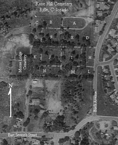
1993 aerial photo from the USGS.
1993 aerial photo from the
USGS.
Rose Hill Cemetery is Rifle's largest and main cemetery. The first burial was in 1896. Several 'residents' were moved from older cemeteries to Rose Hill so there are tombstones dating from 1893.
The Moose Lodge Cemetery joins Rose Hill on the west and until recently was operated as a separate cemetery. It was transcribed separately for this project.
The formal Rose Hill Cemetery lot system runs from #2 (the oldest) to #48 (the newest). The area that would be section #1 contains a pumphouse and maintenance shed. To aid in locating the official lots the cemetery was divided into 14 areas (A-L).
The lettered areas shown on the map above contain the following cemetery lots:
| Map Area | Cemetery Sections (Lots) | ||||
| A | 2 | 6? | |||
| B | 3 | 5 | |||
| C | 4 | ||||
| D | 7 | 14 | 15 | 22 | |
| E | 8 | 13 | 16 | 21 | |
| F | 9 | 12 | 17 | 20 | |
| G | 10 | 11 | 18 | 19 | |
| H | 23 | 30 | 31 | 38 | |
| I | 24 | 29 | 32 | 37 | |
| J | 25 | 28 | 33 | 36 | |
| K | 26 | 27 | 34 | 35 | |
| L | 45 | 46 | 47 | 48 | |
| M | 39 | 42 | 43 | ||
| N | 40 | 41 | 44 | ||
Return to: Garfield County USGenWeb Archives Index
Return to: Colorado USGenWeb Tombstone Transcription Project Index
Back to the Colorado Tombstone Photo Project - Rose Hill page.