Milam County Texas Archives
SURROUNDING COMMUNITIES |
|
| 1. Bethlehem | 16. Minerva |
| 2. Big Lump | 17. New Salem |
| 3. Black Jack | 18. Oak Hill |
| 4. Bushdale | 19. Pleasant Hill |
| 5. Duncan | 20. Praesel Addition |
| 6. Eagle | 21. Salty |
| 7. Forest Grove | 22. San Andres |
| 8 Gay Hill | 23. San Gabriel |
| 9 Hamilton Chapel | 24. Sand Grove |
| 10. Hickory Grove | 25. Sandy Creek |
| 11. Hicks | 26. Sharp |
| 12. Liberty Hill | 27. Sipe Springs |
| 13. Lilac | 28. Talbott Ridge |
| 14. Marjorie | 29. Tracy |
| 15. Millerton-Sandow | 30. Watson Branch |
Bethlehem, a farming community three miles north of Rockdale was named for the Biblical city of Bethlehem.
Some of the early settlers who came to this area were Wilhelm Guthman, August Seelke, Sr., Charles Brockenbush, Tom Phillips, S. W. Christian, Henry Walker, Antone Strelsky, J. M. Corley, Dr. Isaacs, Spratt Wilson, David Hamilton, William P. Henry, Oscar L. Moody, Joe Frank Horton, Carl Kraatz, William Luetge, J. Busby, and Thomas Murray.
The first school in this area was a one room building called Pleasant Grove located by the Murray Cemetery, later moving east of this location to land owned by the Kraatz family. Several years later a new building was erected on Dr. Isaacs' land near the Cat Tail Creek so it was called Cat Tail. On Feb. 8, 1897, Cat Tail school consolidated with the Bethlehem school which stood east of the intersection of Farm Roads 487 and 1712.
By 1919 the community was booming with oil so a new three room building was erected. Part of the building still stands, located one mile off Farm Road 487.
Dr. Isaacs came to the area about 1880. He acquired several hundred acres of land which is still called the Isaacs Ranch. He was a man who stood seven feet tall, making house calls here and in surrounding areas.
Mr. Busby was a constable as well as a United States marshal. He was stabbed to death by a Mexican.
The Carl Kraatz and William Luetge families arrived in Bethlehem Community about 1880. They came from Austin County and brought with them slaves, a colored family by the name of Cummings. Some of the Cummings family still live in Rockdale.
Since cotton was the main crop, a gin was built near the San Gabriel River. It was owned by the Phillips family. Later it was sold to Fritz von Gonten, Sr.
One of the most interesting citizens from Bethlehem was Fifer Caudle. He operated a refinery, a genuine oil refinery, built by his own hands out of whatever he could find to put it together. He operated it without any help. He use to boil off crude and make kerosene and two grades of gasoline that w-ould burn first rate in the automobiles used at that time. This was done in the 20's when Rockdale Oil Field activity was at its peak.
BIG LUMP
(Researched by Mrs. Ida Jo Marshall)
Big Lump was a former lignite mining community on the Missouri Pacific Railroad four miles west of Milano.
Big Lump had a Mexican Catholic Church. This building stood across the International and Great Northern Railroad tracks from the Big Lump stores. Big Lump had a post office. C. K. Stribling and Guy Clymore had charge of the post offfice.
Sam Taylor was superintendent of Big Lump Coal Mine. The coal company also operated a commissary where the employees bought their supplies. Guy Clymore was foreman of the Big Lump mine and was accidentally killed by an International and Great Northern switch engine on March 16 1927.
There was a cotton gin at Big Lump. It was built in the ear;y 1900's and operated several years.
BLACK JACK
(Researched by Mra. Myrtle Whlte Voorheis)
The early history of the Black Jack Community, also referred to as The Sand Hills, is limited to the memory of the present older generation. Several descendants of these early settlers, including the Willards, Keys, Mortons and Dosses, still live in this area and from them and others this historical information has been prepated.
Black Jack is located in Burleson County. It extends to the Milam County boundary line. It is a trade area of Rockdale.
There was a log building near and below the cemetery which served both as a church and a school. The seats were split logs called "puncheon." They were made of heavy, broad pieces of roughly dressed timber with one side hewed flat.
Later a school was built east of the present church. This school building burned in 1905 and was rebuilt. About 1925 a new school building was erected.
A Mr. Riddle taught in 1880 or near that time. Herman Price remembers Tom Parker teaching him when he was a boy. Mr. Price is now 87 years old.
He and Frank Willard recall that the year of 1898 was when the big flood came. It was the worst flood in the history of this area. Bridges, fences and soil were washed away leaving deep gulleys. Wade Brymer was the school's teacher in 1898.
Other early teachers were Hinton Pruitt, Lodge Hallaman, Mr. Reddick, Miss Jessie Goodman in 1907, Mr. and Mrs. Lloyd Green, J. H. Hilliard, Tommie J. Newcomb and others.
A new church was built. In 1953 the church had Sunday School rooms added. Although it is no longer an active church, the building is kept in good repair and serves the community as a place to gather for singing and for the annual homecoming.
The cemetery is well kept. The land was given by Newt Jones and later Mrs. Louis Leroy (Annie Doss) Willard gave more land to enlarge the cemetery. In recent years more land was given by Raymond Willard.
The fence around the cemetery was given by the Casey family. J. W. Casey of the Porter's Chapel community gave the fence posts. They were split mulberry from his Yegua farm and were cut and hauled by the black men on his farm. The money for the wire was given by Mrs. Mary Sproles Casey, widow of Dennis Casey who was a brother of J. W. Casey.
The tombstones bear witness to the names of most of the early settlers.
Perhaps the earliest of the settlers was the Adams family. Two graves are in the field where they lived with fieldstones for markers. The Mayes family was also early settlers. Other families were Mason, Guthrie, Rogers, Griffn, Castleberry, Pippin, Chandler, Doss, Willard, Key, Morton, Jones, Newman, Harklerode, Sproles, Hilliard, Boyd, Skinner, Wade, Ray, Butler, Burrough, Hillin, Perry, Tuma, and Cherry.
It was interesting to learn that many of the early settlers had come from Natchez and French Camp, Mississippi. They were friends there so when their relatives came to Texas they would follow. Newt Jones and his wife Mary Elizabeth Harklerode came from Mississippi soon after he had served in the Confederate Army during the Civil War. He settled near the Black Jack Church and in 1872 their first child was born. This was the mother of Mrs. O. V. (One Gravener) Massey.
Bill Newman married Betty Harklerode. He also served in the Civil War. The Harklerode family came from Mississippi where he had been the owner of a large plantation and slaves.
Bud Doss and wife, Mattie, came from Natchez. They were the parents of Annie Doss who married Louis Leroy Willard. He came from Chicago, Illinois, where he had served in the Union Army during the Civil War. While at a Union Camp some southern prisoners were brought in. He was informed that one of the prisoner's name was Willard. He looked up the prisoner and found he was his brother who had gone south some years before. The two brothers had a reunion after many years of separation.
Dennis Casey came from near French Camp, Mississippi. He was the son of Miles Casey who was from Fayette County, Alabama. Both had served in the Confederate Army.
James Nicolas Morton, wife and children came from Holmes County, Mississippi in 1885. He was a veteran of the Civil War serving with the Virginia Volunteers. When they arrived, Jim Morton, one of their children was twelve years old.
Isaac Chandler had a daughter named Belle who married R. F. Griffm. Lillie Virginia Chandler married Jim Morton.
This community is a rural, agricultural and cattle raising area. Various field crops are grown successfully.
Students from the Black Jack school in Burleson County attended the Rockdale Public Schools for the first time in 1949. School busses transport the students.
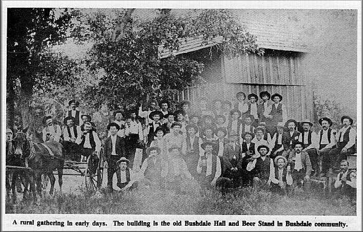
BUSHDALE
(Researched by Mrs. Roy Lee von Gonten)
Bushdale is said to have been named for the valleys and woods characteristic of the area. The earliest settlers were of German descent. Among the group that came were Adolph Stork, Jacob Stork, Frizt von Gonten, Sr., George A. Doss, Bernhardt Hirt, Henry Brockenbush, Herman Henniger, Ludwig Menn, Henry Gustav Backhaus, A. Mayer, John Strube, Paul Pieper, John Brockel, Ferdinand Voss and Mrs. Tracy Seidl.
Ben Loewenstein, a Rockdale resident, came to the home of Mrs. Tracy Seidl, a widow, to each the children in the community. Later a building was erected near the graveyard and was used for church services and for a school. Bushdale school consolidated with Rockdale July 6, 1949.
The Reverend Immanuel Glatzel organized Peace Lutheran Church on June 24, 1883, in the small German community a short distance from Rockdale. The first resident pastor, Reverend Julius E. H. Schroeder, a young theological candidate from a German seminary arrived in 1888. Under his leadership the first church and parsonage were built.
 Bushdale was a lively community in the early
days with a large dance hall where the Herman Sons Lodge #61 sponsored picnics with plenty
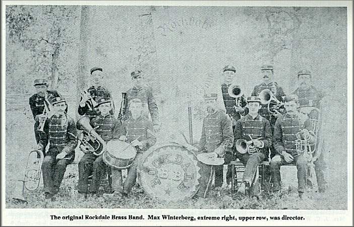
of barbecue and barrels of beer. The parade with a brass band under the direction of
August Seidl, Sr. would begin in Rockdale and continue to the hall for a dance.
Bushdale was a lively community in the early
days with a large dance hall where the Herman Sons Lodge #61 sponsored picnics with plenty
of barbecue and barrels of beer. The parade with a brass band under the direction of
August Seidl, Sr. would begin in Rockdale and continue to the hall for a dance.
The May Feast, July 4th holiday, October Feast and Christmas were the big celebrations. After the leader's death in 1907 the band disbanded. A man's singing group and the Farmers' Union held their meetings at the hall. In 1894 a Society of Froshin was organized.
Besides the hall, there was a grocery store operated by Johnnie Brockenbush, a cotton gin and a blacksmith shop owned by Henry Gustav Backhaus.
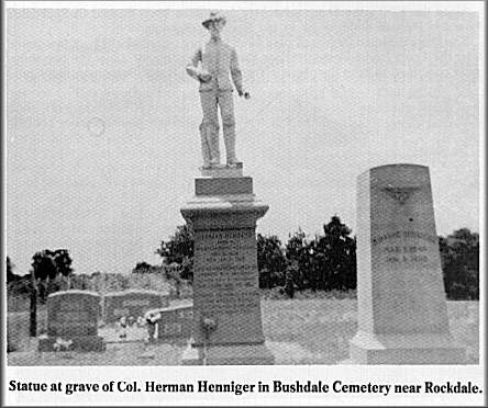 Herman Henniger, a farmer at Bushdale and the
man who gave the seven acres of land for the first Lutheran Church, immortalized himself
in the local graveyard by erecting an almost life size statue of himself in Federal Army
uniform with the inscription which recorded that he had been a "late and honored
member of Company B of the twelfth regiment of Illinois Calvary."
Herman Henniger, a farmer at Bushdale and the
man who gave the seven acres of land for the first Lutheran Church, immortalized himself
in the local graveyard by erecting an almost life size statue of himself in Federal Army
uniform with the inscription which recorded that he had been a "late and honored
member of Company B of the twelfth regiment of Illinois Calvary."
Another interesting citizen of this community was August Seidl, Jr. who was disabled by paralysis from the age five years. He was interested and active in all community affairs. He was election manager for 52 years. He was a school trustee, and an officer of the Cemetery Organization.
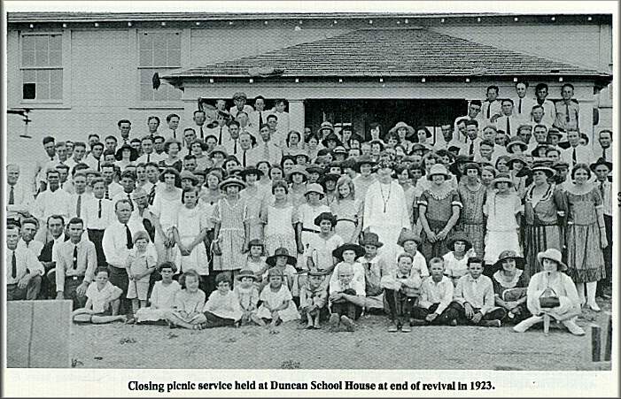
DUNCAN
Researched by Mrs. Mabel Charles)
 Duncan is an agricultural community twelve
miles northwest of Rockdale. It was named for the donors of two acres of land, George and
Elizabeth (Bettie) Duncan, where the first schoolhouse was built in 1892. It was located
on a, hillside north of Alligator Creek, in Milam County.
Duncan is an agricultural community twelve
miles northwest of Rockdale. It was named for the donors of two acres of land, George and
Elizabeth (Bettie) Duncan, where the first schoolhouse was built in 1892. It was located
on a, hillside north of Alligator Creek, in Milam County.
This school building had one room only. It was equipped with a blackboard and double desks in which the students sat. The attendance grew to about sixty. Two teachers were employed.
 After a few years of this crowded situation, a new building was needed. In order to
receive State Aid and approval, in 1917 the s~te was moved to level ground upon a hill.
One acre of land was donated and one acre was purchased. With increased space, Christmas
programs, home talent plays and other programs the school building furnished an
entertainment place for the young people.
After a few years of this crowded situation, a new building was needed. In order to
receive State Aid and approval, in 1917 the s~te was moved to level ground upon a hill.
One acre of land was donated and one acre was purchased. With increased space, Christmas
programs, home talent plays and other programs the school building furnished an
entertainment place for the young people.
During the early 1920's a union Sunday School was held in the afternoon.
A Presbyterian preacher from Sharp held a series of services one summer. Young people came from surrounding communities.
Ten grades were taught until 1931 when the high schoof~was consolidated with the Sharp school. Students living south of Alligator Creek went to San Gabriel. In the mid 1940's all the other grades and a teacher went to Sharp. Finally the building was torn down and moved to Sharp.
 Since the 1960's the Sharp school children have
been bussed to Rockdale. Now the Duncan children go to the Rockdale Schools, too.
Since the 1960's the Sharp school children have
been bussed to Rockdale. Now the Duncan children go to the Rockdale Schools, too.
The Duncan Home Demonsttation Club was organized in 1927. A few years later the 'I racy Home Demonstration Club was organized. Later the two clubs were combined to form the present Tracy-Duncan Home Demonstration Club.
EAGLE
(Researched by Mrs. Hallle McCoy)
The community of Eagle in Milam County was nine miles due south of Rockdale. In 1894 it consisted of a Primitive Baptist Church and a school.
In 1893 Mr. Jim White deeded an acre of land for the church which was moved to this location from Bealah, a community in Lee County.
In 1894 Mr. Jim White also deeded one acre of land adjoining the church ground to the school which was then moved to one-half mile away to this location.
Pleasant Swendell was the first person buried in the Eagle Cemetery which is across the road and just north of the church and school.
In the early 1900's there was a post office in the Neal [lolliman home which was very near Eagle. The mail was brought from Tanglewood by "horseback. "
An elderly doctor named "Wilson" lived in the Neal Holliman home a few years beginning with 1903. This was a great convenience for the people of this area.
Four times a year, at a Sunday preaching service, the pastor and members of this Primitive Baptist Church (called Hardshell Baptist Church) conducted "foot washing" services. This was a solemn and impressive service.
As time moved on, the members of the church moved away. Some time between 1930 and 1935 the church was moved to Rockdale. Services were held there until 1940 when the church was disbanded.
Eagle was the first school district in Milam County to build a new school, using money from a Rural State Aid Fund, created between 1914 and 1916. In 1918 Mr. Jim Tyler sold three acres of land to Eagle school. This affored more playground for the pupils.
Mrs. Alma Doss was the last teacher of the Eagle school. She and the pupils were moved to the Rockdale school in 1939.
In 1948 the Eagle school building was moved to Aycock School in Rockdale. In 1966 it was moved to its present location at the Rockdale Elementary School.
At the present time, the cemetery is all that is left of Eagle Community.
FOREST GROVE
(Researched by Mrs. Claude Spenco)
Years before this community was named Forest Grove, the cemetery was started on the hill west of the present church building and was called Hat Prairie. Two stories were related to this name:
1. The open space on the hill was shaped like a hat.
2. A fellow riding by on horseback lost his hat and sometime later found it on top of the
hill.
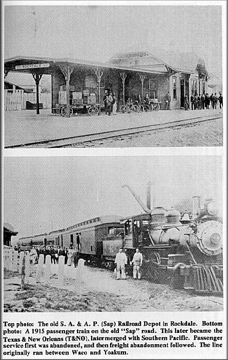 The first train on the S.A.&A.P. Railroad
came through in 1888-no railroad left now.
The first train on the S.A.&A.P. Railroad
came through in 1888-no railroad left now.
At a protracted meeting held by C. S. Watson and C. A. Leecraft in August, 1898, a congregation was organized by appointing as a board of elders, W. W. Kyle, J. R. Lothlin, and R. S. Stanley and as deacons, Richard Boswell, H. B. Duncum, Frank Bounds.
The congregation met at Oak Hill schoolhouse on Sept. 13, 1902, and reorganized with W. W. Kyle and J. W. Crim as elders, and Frank Bounds, J. B. R. Smith, J. P. Keen as deacons. The old church building was built in the fall of the same year at a cost of approximately $300 and was paid for except $25. W. W. Kyle suggested the name Forest Grove because he knew a place in Missouri by that name. The building was dedicated on the 4th Lord's Day in January, 1903.
Forest Grove had the first homecoming on October 15, 1956, and started a building fund for a new church. On the third Sunday of September, 1959, the last services were held in the old churchhouse with James Diamond preaching. The free-will offering on that day was $1600 for the fund. The old church was moved the following week and the recreation building was used for all services until the new church was finished. The first service in the new one was on January 24, 1960. Dedication services were on April 24, 1960, with five preachers in charge: James Diamond, James Mantooth, Edward Fraim, Charles Jarmon, and Hollins DuHon.
Hicks was a very activepart of the community for years. In the 1920's there were a section house, a depot, two stores, a cotton gin, a coal mine, several small rent houses, a three-teacher schoolhouse, a blacksmith shop, a post offce, and a commissary. Now none of these are left. In 1917 and 1918, rows and rows of cordwood were stacked beside the railroad near the school and several people said they would walk through the stacks on their way to school each day.
Some of the senior people told from memory some of these facts. Two doctors were in the Hicks community: Dr. T. L. McLarty and Dr. J. P. Sparks. Joe Magee was one of the managers of the coal mine. Robert Stence, Tom Paul, Will Crim helped operate the commissary. Lee Scarbrough, W. O. Hollowell, and Will Alexander were owners of the stores. Charlie Gard operated the gin. Teachers were Winnie Fitzgerald, Betty Childs, Myrtle Browder, Carrie Spence. A Woodman Hall stood south-east of the church and had active members. A Literary Society used the hall for meetings too.
There was another school in the area, Oak Hill, located on the southeast corner of the now Fritz Doss farm on Highway 77. Children who attended had to walk, some several miles. Teachers were Guy and Fred Eads, Edna Cook Ruby Aldridge, Ruby Hickman, Bolivar Carlyle, Johnny Cherry.
For entertainment baseball games were played, house parties held, basketball games, dominoes, etc.
Looking at the markers in the Forest Grove Cemetery the oldest one with printing that is readable is D. B. Hughes, died 1856. (relative of the Overmans)
At this writing, the church building is paid for and citizens are paying for the new three bedroom parsonage. Besides the regular church funds, the Forest Grove Memorial Fund was started at the death of Henry Spence, September, 1969, and the cemetery fund is used for upkeep.
GAY HILL
(
Gay Hill is a thriving community located seven miles west of Rockdale on Highway 79. The early settlers of this community were mostly of German descent: namely, John Timmerman, Sr., George Doss, Sr., Fritz Stolte, William and Julius Henke, Joseph Brown, Otto Praesel, Fritz Dornhoefer, Fritz Voss, Fritz Helmeke, Carl Pieser and Joesph Pelzel.
T. J. Eiland, M. Morrison, a Mr. Strader of Alabama, and Mrs. Frank and Joe Dockall were of Czechoslovakian descent.
Mr. Fritz Voss donated the land for a one-room. one-teacher school in the mid 1870's which was then District No. 26. In 1895 it became District 16 which it still remains. The first trustees were J. C. King., T. J. Eiland and H. J. Alford. In 1910 it became a two- teacher school. Another room was added to the original building. In 1929 a new, modern, three-room school building was erected, and three teachers were employed. On July 6, 1949, it consolidated with the Rockdale Public School System. The last trustees were C. L. Eiland and John Timmerman.
In earlier days the community had a post office. It was called Fletcher. A cotton gin was owned and operated by Fritz Dornhoefer, Sr. The gin was purchased later by Frank Dockall who also owned a grocery store and a dance hall. In the early 1920's the store was sold to John Timmerman and was operated by his son, Walter Timmerman. Also another grocery store and garage were owned by Emil Dockdall. These places of business ceased operation in the late 1930's.
There is also a cemetery at Gay Hill. Its name is the Davison Cemetery.
HAMILTON CHAPEL
(Researched by Dorls Shoppard)
Hamilton Chapel is a thickly settled rural, agricultural community three miles southwest of Rockdale. The land was purchased from land grants made during the Republic of Texas. Established were a school, a church, a cemetery, and a voting precinct. It was named Hamilton Chapel for John W. Hamilton.
Deed records dated January 15, 1877, show that W. A. Hamilton conveyed, to heirs of John W. Hamilton one acre of land for a Methodist church. This chapel was used for a church and a one-teacher school.
Later it became a two-teacher school from grade one through nine. The school was consolidated with the Rockdale Public Schools in 1939.
The voting precinct dates back to 1886 and was also transferred to Rockdale in 1939. The cemetery at this location has grave stones dated as early as 1869.
Private first class Hicks R. Carlyle, 141st Infantry, 36th Division, World War 1, one of the two Carlyle brothers for whom The American Legion Carlyle Pos~t in Rockdale was named, is buried in the cemetery. The brothers were kUled in the same battle on October 8, 1918. The body of Corporal James W. Carlyle' was not recovered for burial.
Most of this land has changed ownership many times and much of it now belongs to McAlester Fuel Company.
The Rockdale Country Club is located about one mile south of the cemetery.
HICKORY GROVE
(Researched by Mrs. Ida Jo Marshall)
Hickory Grove is a rural, agricultural community five miles northwest of Rockdale. It was settled by persons of German descent. Some of the earliest families of the community were Pelzels, Palmers, Dosses, Walters, von Gontens, and Storks.
There is a Catholic cemetery established there. A rural school was built and served for many years. It consolidated with the Bushdale and the Gay Hill rural schools later. When school consolidation became more popular due to bussing and more adequate financing, these two schools, Bushdale and Gay Hill, consolidated with the Rockdale School System.
HICKS
(Researched by Mrs. Thelma Kyle Watoon)
The Hicks community which is about one-third mile south of the Milam-Lee County boundary line and is located on old Highway 77. In years past, there was a railroad station, a freight offfice, large home for the section forman, and two small houses for the section hands.
There was a larger general store that sold everything a family would need from groceries, dry goods, to many types of implements.
There was a post office which was served by different postmasters. Mail carriers delivered the mail on Monday, Wednesday, and Thursday from December 1, 1919, to Nov. 1, 1933. At that time the Hicks route was consolidated with the Tanglewood rural route.
A gin was in Hicks which often ran 24 hours per day to take care of the large harvest of cotton that was produced in this area.
A lignite coal mine was situated in the community. This mine employed a large number of Latin-Americans who were supervised by Anglo-Americans.
In connection with the mine there were about fifty houses owned by the mining company, also a commissary that served the mine employees for several years. A cemetery was located east of the mine which was used for the purpose of burying Latin-Americans who died while laboring for the mine.
There was only one other cemetery in the Hicks community. It was named Honey Hill. It is located on the Sherar farm. Being a family cemetery, it was on the Sherar's Farm. It was here at the Sherars and the Anthises were buried. It is on the south bank of Allen's Creek.
Hicks now had rows of cordwood that were stacked near the railroad to be shipped to prairie towns that were located on the S.A.&A.P. Railroad. This cordwood was from the land being cleared for the purpose of making it fit for farming. Cotton and corn were the chief sources of money at that time.
The Hicks school district started with a one-teacher school that often had as many as 75 students from the first through the seventh grades. It finally had a three-room building with as modern classrooms as could be found in a rural school. Also, a one-room school for Latin-Americans and a two-room school building for the Negro children.
Following two fires (by arsonists) that destroyed the buildings the school district divided. The western half of the district consolidated with Tanglewood school district. Later, both east and west parts of the school district consolidated with Lexington Independent School District.
Hicks is now a community of improved pasture land. There are some fields of peanuts, corn and watermelons, but most of the area is used for cattle grazing.
Within the old Hicks School District there now reside only five people who attended the Hicks school. They are Buck Richards, T. J. Kyle, Thelma Kyle Watson, Alva O. Watson, and Hubert P. Watson.
LIBERTY HILL
(Researched by Mrs. Estelle Dykes)
Liberty Hill is an agricultural community ten miles northwest of Rockdale with a predominantly Negro population. It is located on Farm to Market Road No. 908.
The soil in this community is very fertile. Most farm crops thrive in this rich soil. Cattle, hogs, sheep, goats and poultry are raised in abundance.
The Springfield Baptist Church was organized in 1888 in an old log house.This church has grown greatly in the years since its founding. Luncinda Goff Haynes is the oldest member of this church at present. She gave the welcome address when the church was first organized. Many people have served in various positions in this church.
There were two schools in this community. One was called Little Two, which was on the south end of the community in the Ellison Ridge District. The other was called Big You and was close to the church in San Andres District. They were merged in the thirties. In1940 Big You burned. The term was finished in the white schoolhouse in the San Andres District. The next year the building was moved to Liberty Hill Community where the old school had burned. It remained at this place until the school transferred to Rockdale, Texas. The children had to ride a school bus. The school was in the San Gabriel District at this time and remained in this district until they were later transferred to Thorndale, Texas.
LILAC
(Researched by Mrs. H. L. Summero)
Lilac, a farming and stock raising community of northwest Milam County, is fifteen miles northwest of Rockdale.
The community of Lilac grew out of the plantation and cattle raising operation of Frederick Agustus Graves, an early day settler in northwest Milam County. He was born May 17, 1847, and settled there as a young man. So far as can be determined Lilac commenced about 1867, and was known as Oak Point until a post office was established. There was another Oak Point so the name was changed to Lilac. At one time the plantation was a self sustaining operation with a cotton gin, mill, blacksmith shop, brick kiln, grocery store, doctor and dentist offices, a school, a church and a cemetery. Justice Court was held there and a very active Woodmen of the World Chapter met in the old hall above the grocery store.
Later, Fred A. Graves moved to Rockdale. His son, Rufus Winton, remained in the Lilac community continuing in the cattle raising business until his death in 1965.
Thomas Graves, brother of Fred A. Graves, lived in the community and reared his family there. He and his sons, Paul and Henry, were all very active in cattle raising and farming. Mr. Thomas Graves is buried in the Lilac Cemetery.
On Dec. 9, 1884, Fred A. Graves deeded to Milam County one acre of land for a public school. (Court Records-Milam County Book 19-Page 352)
One acre of land was deeded by S. T. Rister in 1887 for a Baptist (:hurch and a cemetery at Lilac. (Court Records-Milam County Book 164-Page 1)
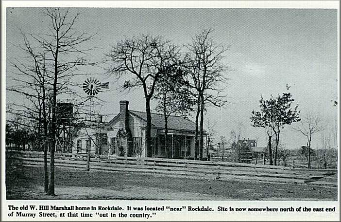 This community had many sturdy farm families.
Some of these were W. Hill Marshall, A. Norman, John Baldridge, Sam Richmond, Breeze
Wilson, Ed McRee, J. E. Hook, Will Stigall, Val Nenec, Antone Yakesch and many more. Mr.
Ross McQuarry who was very active in school affairs still resides here.
This community had many sturdy farm families.
Some of these were W. Hill Marshall, A. Norman, John Baldridge, Sam Richmond, Breeze
Wilson, Ed McRee, J. E. Hook, Will Stigall, Val Nenec, Antone Yakesch and many more. Mr.
Ross McQuarry who was very active in school affairs still resides here.
MARJORIE
(Researched by Mrs. Ida Jo Marshall)
 Marjorie is on the Missouri Pacific Railroad
five miles west of Rockdale. Here branches off the Rockdale Sandow and Southern Railroad
which leads to Rockdale Works of the Aluminum Company of America.
Marjorie is on the Missouri Pacific Railroad
five miles west of Rockdale. Here branches off the Rockdale Sandow and Southern Railroad
which leads to Rockdale Works of the Aluminum Company of America.
 Construction of the six mile long Rockdale Sandow and Southern Railroad was started by the
Federal Fuel Company in 1918. Before tbe little railroad could get into operation, the
Federal Fuel Company went bankrupt, and not until the McAlester Fuel Company took over,
did it begin to run. The McAlester Fuel Company's first car went out of the Sandow station
Christmas Eve of 1923.
Construction of the six mile long Rockdale Sandow and Southern Railroad was started by the
Federal Fuel Company in 1918. Before tbe little railroad could get into operation, the
Federal Fuel Company went bankrupt, and not until the McAlester Fuel Company took over,
did it begin to run. The McAlester Fuel Company's first car went out of the Sandow station
Christmas Eve of 1923.
The Rockdale Sandow and Southern Railroad hauled as many as 6,552 carloads of lignite a year over its roadbed from Sandow to Marjorie.
MILLERTON-SANDOW
(Researched by Mrs. Robert N. Baker)
 Millerton-Sandow community is located in the
southwest part of Milam County. A schoolhouse was built there before 1900. The building of
the schoolhouse was of prime interest to the local residents. It was built of bricks made
by hand. The location of the school was just north of the present Alcoa Administration
building. The school building stood until the Alcoa plant construction was well under way.
Millerton-Sandow community is located in the
southwest part of Milam County. A schoolhouse was built there before 1900. The building of
the schoolhouse was of prime interest to the local residents. It was built of bricks made
by hand. The location of the school was just north of the present Alcoa Administration
building. The school building stood until the Alcoa plant construction was well under way.
Also, this community has always been known as "Freeze-Out" but no knowledge of the origin of the name has been found. The school was paid for by money donated by Mr. Beardy Miller who was a bachelor from Georgia. He died as a result of injuries sustained from a bull. He is remembered for his generosity, thoughtfulness of others, and willingness to furnish what he could for a future generation.
There are two cemeteries in the vicinity, the Garner Cemetery and the Miller Cemetery.
MINERVA
(Researched by Mrs. lda Jo Marshall)
Minerva is an agricultural community on the Jose Leal survey south of Cameron. It's located in central Milam County, six miles north of Rockdale. Also, it is a rural community which contained churches, a school and a village. It was named for Mrs. Adeline Minerva Sanders who gave land for the town site, for the railroad, and for the Methodist Church.
Midway was the small village from which Minerva originated. Midway was about a mile or more from where Minerva was later built. It was a small village on the public "sandy" road. It was midway between the two larger towns of Rockdale and Cameron; therefore, it was named Midway. This small village consisted of a few homes with residents, a Church of Christ, a school, but no stores. The people had to go to Rockdale or Cameron to purchase their supplies.
About 1891, the San Antonio and Aransas Pass Railway company from San Antonio, Texas, was building their railroad from Waco to Yoakum. Mrs. Minerva Sanders sold this company the right-of-way through her property to induce the bringing of the railroad through this area. When they wanted to survey a town site there, she gave them about thirty acres of land for this purpose, requesting they keep a depot and an agent there for fifty years. In appreciation for her gift, they named the town Minerva in her honor. The last time their train went through this station was August 13, 1949.
Mrs. Minerva Sanders gave the land for the Methodist Church, also. The first pastor of this church was Reverend S. P. Brown and the first Sunday School superintendent was Mr. W. O. Cone. The first wedding in this church was that of Mr. John C. Wallace and Miss Willie B. Cone.
During the eighty active years of the Methodist Church, it was the center of the religious and social activities until it was closed on March 2, 1969. This is evidenced by former residents who return to visit the Annual Homecoming each year since it was started on October 7, 1961.
Minerva was a larger village than Midway, but it was still small. The town then consisted of a drug store, a few grocery stores, a post office, Methodist Church, Church of Christ, and the Baptist Church.
The first public school was built in 1884. It consisted of two rooms and was named Midway School because it was about half way between Rockdale and Cameron on the highway. It was Milam County School District #33. In 1913, the trustees, Mr. J. W. Wallace, Mr. W. A. Robinson and Mrs. J. W. Gore gave the school building and lot for one and one-half acres of land adjacent to Minerva town lots which were east of the Methodist Church. A three-room building was erected just outside the city limits. The name was changed to Minerva School. This was in 1913-1914. The Milam County School Board annexed one-half of the Minerva School, south of Cooper Hollow to the Rockdale School on July 6, 1949. The school building was donated to the Minetva community as a social center. It was named The Minerva Community Center.
One day oil was struck near Cattail Creek in Minerva. This discovery was made by Sam Whonstein about 1920. He worked with an oil drill and oil tools which sometimes broke and then would have to be fixed together again. Then one day he found oil. It was the year of 1921.
This oil was first leased and bought by individuals, but later companies came and bought the oil. Minetva increased greatly in population. Not only did it grow in population but soon consisted of many houses, stores, markets, and a post office. The oil refinery, in the oil fields, was supetvised by Mr. W. A. Jones who was from the State of Oklahoma. This oil field is closed now.
The first postmaster was Dr. Harber who was also a doctor. Mrs. Mason (Bernice) Longmire was the last post mistress. The post office closed Octobet 13, 1972.
Today Minerva has gone back to a very small village. Students are attending Rockdale Schools by bus.
NEW SALEM
(Researched by Mrs. Erned Foster)
New Salem is a rural eommubity five miles southeast of Rockdale. For a number of years it was a rather thickly populated area with a family for about each one-hundred acres of land. Farms were rented on a basis of third and fourth with the tenant paying the landlord one-third of the cotton and one-fourth of the grain. Gradually the community turned from farming to stock-raising and today there are only a few families living in the area. A voting precinct was established in the community in 1886.
The first telpehones were installed about 1910.
Oakdale, New Salem and Lewis rural schools were consolidatd and a two-story school building was erected near Harmony Church. The school trustees at that time were Y. A. Gjedde, Howard Richards and S. B. Ford.
Harmony Baptist Church was organized in 1875 by combining New Salem Baptist Church and Briar Branch Baptist Church with Elder W. T. H. Beasley as pastor. Membership of the church was twenty-four members. Rev. Beasley served as pastor for twenty years. Another pastor and outstanding citizen was Reverend J. D. Shelton who served the church for about sixteen years. He was also an excellent surveyor whose setvice was used by many citizens. Other pastors through the years were Reverend Spradley, J. M. Rankin Scales, L. S. Darling, W. G. Jackson, O. J. Morgan, Elvin Dickey, J. L. McRae and J. A. Harvey.
Y. A. Gjedde was Sunday School superintendent for many years. With the untiring efforts of himself and his wife, Emma, they manageed to keep the Sunday School active.
After a period during which members were few and the church inactive the few members met and held a conference. They voted to disband the church and to sell the building. The money from the sale was to be used for the upkeep of the Harmony Cemetery which had been established about the same time as Harmony Church. The cemetery is kept nicely and an occasional funeral is still held there.
A distinguished citizen who worked faithfully in the church and community was Dr. T. E. Riddle. He was the only physician in the community. He rode horseback to serve his patients and later travelled by horse and buggy all over the area. He received little or no pay for his setvices.
OAK HILL
(Researched by Mrs. Clyde Holllman)
In the late 1860's a school was built known as Oak Hill. It was located one mile north of Hat Prairie and eight miles south of what is now Rockdale on Highway 77.
Oak Hill was a one-teacher school and Mrs. Ann Richards, Miss Jennie Little and Miss Beulah Littlepage were among the first teachers. During this time there were 77 children attending school.
W. D. Wooten, W. D. Young and W. W. Kyle were the school trustees.
After 1915 or 1916 Oak Hill was a two-teacher school.
In the thirties the children of Oak Hill began attending the Rockdale schools and the school building was moved from Oak Hill to the site of the Forest Grove Christian Church and used as Sunday School classrooms and for a recreation building. It was also used as a church while the new church was being erected.
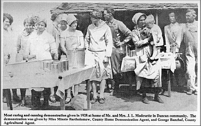
PLEASANT HILL COMMUNITY
(Resenrched by Mrs. Ilallle McCoy)
 Pleasant Hill, a community in Milam County
twelve miles south and slightly west of Rockdale, and three miles south and west of Alcoa
(Aluminum Company of America) was settled soon after the Civil War by pioneers from
Georgia, Alabama, Mississippi and East Texas.
Pleasant Hill, a community in Milam County
twelve miles south and slightly west of Rockdale, and three miles south and west of Alcoa
(Aluminum Company of America) was settled soon after the Civil War by pioneers from
Georgia, Alabama, Mississippi and East Texas.
In 1874 these people organized a Methodist Church. Then through the efforts of Wilbur Walker, Dan and Dave Thomson, W. A. Avrett, Henry Miller, Wesley Blackburn and Lewis Modesett a church building was completed in 1880 on four acres of land that had been donated by Travis Shaw for a church and a cemetery. The first person buried in the new cemetery was a child named Merriweather.
Travis Shaw also donated four acres of land for a school in 1883. The first school was a subscription school. It was taught by Miss Mollie Phillips.
Years later, in 1917, a new two-room school was built. From that time on two teachers were employed.
Pleasant Hill organized a Literary Society that was active for many years. Programs sponsored by this society added much to the social life of the community.
The church was used for religious worship continuously for three quarters of a century.
In 1944 the school was consolidated w*h Rockdale school and the children were bussed into town.
Because this land contained coal, and because the Aluminum Plant of America needed this coal most of the land of this community was sold by the 1950's. Consequently, all the citizens except two or three families moved away.
The church was disbanded in the early 1950's. At the present time, 1973, both the church and schoolhouse still stand. A few people still bury their dead in the cemetery. A Foundation, for the future care of the cemetety, has been established with the Citizens National Bank of Cameron. Twice a year cemetery worxings are held, and one day eacy-year a Homecoming is held by the present and former citizens, who are now too few in numbers.
PRAESEL ADDITION
(Researched by Mrs. Marlon Shoemate)
The Praesel Addition is two and one-half miles south of Rockdale on Highway 77. Floyd Praesel purchased one hundred and seventy acres of land in the fall of 1951 for lots.upon which to build homes, places of business and an office.
The first acre sold was for an eighteen trailer space. Homes began to be built quickly.
To provide water a ninety thousand gallon water storage tank was built.
Today there are ninety homes in the Addition. These homes are situated among beautiful trees, gardens and shrubbery.
A new church building, the Hillcrest Baptist Church, provides a place for worship. Residents are very proud of this church.
Business places consist of a filling station, fiber glass shop, beauty shop, a Teen-Age Club, lumber yard, a dine and dance establishment and Andy's Cafe which is noted for good food.
Later, Floyd Praesel bought more land so as to provide agricultural business and cattle raising.
SALTY
(Researched by Mrs. Dow Caffoy)
Salty is an agricultural community ten miles southwest of Rockdale. It was named for nearby Salty Creek. This creek received its name from salt deposits left on its banks after overflowing.
The first church at Salty was called "Thomson Chapel." In 1871 a new church was built. It was called Salty Methodist Church. Joseph and Sarah Frasure deeded two acres of land for this new church. The first trustees were Saaburn Stiles, Meblor Cropper, Whittington Ford, James Frasure and John Thomson.
In August, 1896, H. J. and Mattie Frasure sold one acre of land to the Salty Methodist Church. Trustees at this time were A. J. Jackson, B. F. Williams and G. M. Jinks.
Also, there was a Baptist Church at Salty. In 1924 this church was sold and the money was given to Buckner' Orphans Home.
In 1950 Salty Methodist Church was rebuilt on the rock foundation of the old church. It is now called Salty Community Church. The pastor at the present time is Reverend Howard Buchanan.
Mr. A. J. Jackson, a pioneer citizen of Salty, organized the Salty Singing Convention. This convention was carried on by his son, a grand-daughter and a grandson about seventy years. It was called The MLlam County Singing ConventJon.
At one time, two doctors, Dr. Brown and Dr. Harkness, lived in the Salty community. Salty had a parsonage, two gins, and a barber shop. A Mr. Amason had the first grocery store. There was a post office and a switch board for a telephone party line.
In 1886 Salty was made a voting precinct. In 1897 Salty was served by a rural mail route.
Some pioneer settlers were Frank Clement, N. Cooper, E. C. Caffey and a Mr. Ralston.
At some time, Walter Ramsel gave one acre of land for the Salty Cemetery. In 1959 Mark and Lucille Towery gave one acre of land to the cemetery. Today this cemetery consists of four acres.
In 1878 the old schoolhouse at Salty was one long building. In 1918 a new schoolhouse was built. It consisted of three rooms and ar~ auditorium.
In 1949 Salty school consolidated with the Thorndale school system.
In 1955 a Salty Homecoming was organized to be held on the second Sunday in August. This has been an annual event since that date.
Salty celebrated its Centennial August 8, 1971.
SAN ANDRES
(Researched by Mrs. Mabel Charles)
San Andres was a town that was laid off between the San Gabriel River and Brushy Creek, sometimes known as San Andres River in the middle 1850's.
From Capitan Domingo Ramon's reports, the first mention of Spain in Milam County was that he encountered the river in 1716 just above its conjunction with the Brazos. Also, Ramon encountered Little River in 1716 and called it the San Andres. Another stream which empties into it was called San Francisco Xavier (San Gabriel) River.
The territory along the banks of the San Gabriel River and Brushy Creek was occupied by various tribes of Indians. In 1744 a missionary from the Alamo came upon them and was granted permission to construct three missions in 1746. They were San Xavier on the Kolb place, San lldefonso on the fork of Brushy and the San Gabriel River, and Nuestra Senora de la Candelarla on the Porter farm.
Traces of these were noted only a few years ago. Marks of irrigation projects have been found on the Ditch Valley Farm.
In 1884 the Methodist Episcopal Church South bought land from Henry 1. and Matilda A. Cravy for a church, a school, and a cemetery. The church was built beside the river road. It was named Lebanon Church. It was on the Davilla charge. The 1921 flood damaged this church beyond repair. The Lebanon Cemetery was situated on a hill west of the river. The San Andres school was a one-room building just south of the cemetery. In later years it was replaced by a two-room building which was moved further south. Finally it was consolidated with the San Gabriel school system. For a few years services and prayer meetings were held in the schoolhouse during the 192D's.
Around a bend and a short way down the river was the Kolb's place which was a big white house on a hill. Also, there was a cotton gin and a store. There were several river crossings in the vicinity: namely, Kolb, Moss, Schulz, and San Andres which was on the main road to Davilla. Floods wrecked the bridge over the San Andres. A prominent man and land owner, Bailey Turner, lost his life in a 1921 flood. His body was finally found nears Port Sullivan.
The San Andres post office was made of huge logs. It was located on the north side of the river. This log building is now a barn on the Mabel Charles' place.
The old picnic ground on the south side of San Andres crossing was a lively place on April 21st for a number of years. Programs for the day were patriotic and political speeches, band music, etc.
Also, religious meetings were held on the picnic grounds.
SAN GABRIEL
(Researched by Mrs. Jun Stewart)
San Gabriel is a village in western Milam County near the San Gabriel River. It was settled during the 1840's by Peter and Jesse Mercer who built log cabins here.
In 1844, near the present village of San Gabriel, Indians killed Peter Mercer who was one of the two owners of the unfinished buildings in Washington-onthe-Brazos in which the Convention of 1836 had met. It was here that the Declaration of Independence had been signed, beginning March 3, 1836. According to local tradition, he was killed on a bluff now known as Mercer's Bluff and his body fell into the San Gabriel River. His grave in the Locklin Cemetery at San Gabriel is marked by a stone with the inscription:
Sacred to the Memory of Peter Mercer
Was born Dec. 25, 1807
and was killed by the Indians June 17, 1844
James A. Clark was among the first settlers, coming here as a young man around 1855 and settling near the Hare Community and later buying land at San Gabriel for 25 cents per acre. Here he lost three wives from illnesses. They are buried in Locklin Cemetery. He then married a woman who bore him seven children of whom four are still living at San Gabriel: namely, Winnie Clark Herron, Leah Clark Anness, Harry O. Clark, and Vallie Mae Clark Terry.
There was a post offce in San Gabriel in 1944. Mail was delivered by horse and buggy. Walter Clark was the carrier. This post office remained in operation until 1965 when it burned to the ground.
In October 1856, the San Gabriel Baptist Church was founded by Elder W. B. Eanes. During the next two years Elder W. N. Mason served as pastor. In 1871 there was a membership of 51. A Sunday School was organized in 1895. The present church was built in 1952 under the leadership of Pastor J. B. Perkins who was a student at the Seminary in Fort Worth.
The San Gabriel Christian Church was organized on April 21, 1854, on the San Gabriel River near Pecan Creek. Thirty years later John W. Hamblin gave the congregation two acres of land on which a building, known as Old White Church, was erected. In February, 1901, they voted to move to San Gabriel where the first service was held on November 10 in the school. A church building was soon erected and it served until 1923 when the present church was built.
A cotton gin, known as the Felton gin was built on the river and was later replaced by one at San Gabriel owned by W. H. Camp, Sr. He and his son, Hope Camp, Jr., operated this gin until the early 1950's. Mr. Frank W. Worley, who was also a breeder of Worley- Boykin cottonseed, built a gin on the San Gabriel River in 1926 and a few years later when the road was changed, he built another more modern gin near the new road and operated it until his death in 1946. Then his son, L. L. Worley, operated it until his death in 1970. This gin was destroyed by an explosion and was never replaced.
Throughout the years a good school, post office, two blacksmith shops, several garages and stores flourished. In 1973 there remains only one garage, no gin, no post office, one store and only the Baptist Church which is still active.
Some of the prominent families were the "Pappy" Camps, whose descendants remain as big land owners, namely Ike Camp and Hope Camp. Of the Locklins only Mrs. Gertrude Locklin Shavers remains on the land. Of the Bairds Harry Gamble is a descendant. Others were the Frank Worleys, of whom L. L. Worley remains, and daughters, Faye Worley Linke and Lula Worley Stewart; the Mel Gilchrist family, of whom only grandsons remain on the land; and the Moore family, of whom Hazel Moore Clark remains.
Dr. Whitfield was one of the early settlers and also Henry Baird who lived in a log cabin on the Felton farm. A Mr. Amason was a well-known store operator and post master for years in the early forties. There was also a Wilburn Clark and Ed Lincoln who owned and operated an ice cream parlor. Bud McQueen was know for his store and also an ice house.
SAND GROVE
(Researched by Mrs. lda Jo Marshall)
Sand Grove is a rural community, named for the sandy soil in a wooded area, in which a voting precinct was located in 1881. It is five miles south of Milano.
The Sand Grove church was organized by John Lincoln, a pioneer preacher, who lived near Lexington, Texas. It was a liberal church and all who wished to come and participate in the church worship and Sunday School were welcome.
Old settlers moved away. Baptist and Full Gospel ministers made attempts to establish churches but these did not endure but for a few years.
Alvin D. McNiel organized a Church of Christ which is still active.
Two cotton gins were built in this community. One was sold and moved away during the 1890's. The other gin was burned.
SANDY CREEK
(Researched by Mrs. Ida Jo Marshall)
Sandy Creek is a stock raising community five miles ftom Rockdale. It was named for nearby Sandy Creek. In 1892 a voting precinct was established in the community. Also, a Red Cross auxiliaty was formed in 1917-1918.
Sandy Creek community was represented by the Sandy Creek Baptist Church, the Christian Church, and later the Church of Chtist. Some of the first ministers remembered were Elmer Lincoln of the Chtistian Church and Reverend Pennington of the Church of Christ. No one seems to remember the Baptist minister. The Baptist Church was the first church at Sandy Creek. Mr. Sam Hamm gave three acres of land for the church and the cemetety. Rocks can still be seen in the northeast corner of the cemetery marking the foundation of the Baptist Church.
In later years the Church of Christ built a church on the south side of the cemetery fronting State Highway No. 79. The building was dismanued and completely rebuilt in 1963.
Bookkeeping records in the County Supetintendent's Office at Cameron, Texas, show that the Sandy Creek school was organized befote 1892-1893 Records before this date were destroyed by fire. This school was consolidated with the Milano Independent School Disttict in 1932.
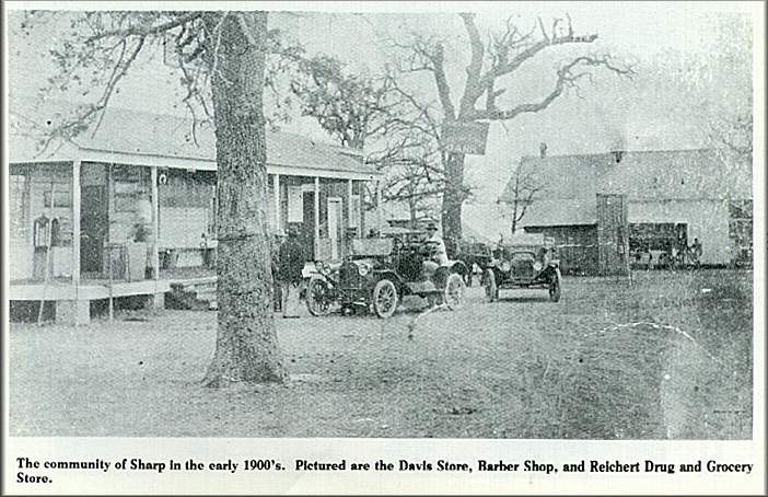
SHARP
(Researched by Mrs. Rufus Graves)
 Dr. W. F. Sharp, a pioneer doctor in Davilla,
practiced his profession over a wide area, riding horseback to see his patients. He was
well known by the people and twice was sent to serve in the State Legislature. He also
served many years on the State Medical Board in Austin. Having studied medicine in
Kentucky he was greatly respected for his medical knowledge, and was loved for his
devotion to his profession and concern for humanity. His financial assistance helped many
young people further their education. Not only did he administer medical aid, but food,
clothing, and shelter when needed without a thought of being repaid.
Dr. W. F. Sharp, a pioneer doctor in Davilla,
practiced his profession over a wide area, riding horseback to see his patients. He was
well known by the people and twice was sent to serve in the State Legislature. He also
served many years on the State Medical Board in Austin. Having studied medicine in
Kentucky he was greatly respected for his medical knowledge, and was loved for his
devotion to his profession and concern for humanity. His financial assistance helped many
young people further their education. Not only did he administer medical aid, but food,
clothing, and shelter when needed without a thought of being repaid.
In 1901 a post offtce was established in this little community without a name. Mr. C. R. Campbell submitted the name SHARP in honor of this beloved doctor. It was accepted. Now we citizens say that we live in Sharp with a tinge of pride.
 Sharp is located in northwestern Milam County
on FM 487 between the Little and San Gabriel Rivers about fifteeen miles from Rockdale.
The soil is black land and sandy loam which is suited to agriculture a'nd cattle raising.
The trees are mostly oak, mesquite and elm. Mesquite grass is one of the most important
native grasses. The bench mark at the cross roads reads 434 feet, somewhat higher in
Sharp, and reaching the highest point in the county above Lilac community.
Sharp is located in northwestern Milam County
on FM 487 between the Little and San Gabriel Rivers about fifteeen miles from Rockdale.
The soil is black land and sandy loam which is suited to agriculture a'nd cattle raising.
The trees are mostly oak, mesquite and elm. Mesquite grass is one of the most important
native grasses. The bench mark at the cross roads reads 434 feet, somewhat higher in
Sharp, and reaching the highest point in the county above Lilac community.
There are traces of old sunken roads through Sharp used over a hundred years ago. One is through the Davis Ranch that went to Friendship. One is through the Lannis Petty place that went to the trading post at Bryant Station on the Little River.
The low valley just east of Sharp is called Belcher's Gap. Old-timers say it was the path followed by the buffalo between the two rivers.
 There are many German settlers around Sharp. On
Feb. 17, 1894, S. W. Slayden sold to the trustees: T. E. Westerman, Ed Kastrop, and J.
Schroden three acres of land out of the D. Huffman survey, for the purpose of securing for
the community a building site for a school, church, a hall and a burial ground. This was
known as the Lutheran Church and the Felton School located southwest of Sharp. In 1955 it
merged with the Peace Lutheran Church in Rockdale and the buildings were torn down.
However, the burial ground was located on a piece of land donated by a Mr. Urban and is
known as the Urban Cemetery.
There are many German settlers around Sharp. On
Feb. 17, 1894, S. W. Slayden sold to the trustees: T. E. Westerman, Ed Kastrop, and J.
Schroden three acres of land out of the D. Huffman survey, for the purpose of securing for
the community a building site for a school, church, a hall and a burial ground. This was
known as the Lutheran Church and the Felton School located southwest of Sharp. In 1955 it
merged with the Peace Lutheran Church in Rockdale and the buildings were torn down.
However, the burial ground was located on a piece of land donated by a Mr. Urban and is
known as the Urban Cemetery.
The Cumberland Presbyterian Church, east of Sharp, was founded in 1872 by Widen Grantham. This is the location of the Sharp Cemetery, but a church is no longer there. The two oldest marked graves in this cemetery are those of Susan F. Dilworth (buried in ld~), mother of L. S. Dilworth, and F. M. Baldridge (buried in 1886).
There was a one-room school in the Dilworth pasture. Mrs. Ross McQuarry was once a teacher there, as were Mrs. Fred Davis, Miss Lavender Wilson and Miss Annie Lee.
 The pretty little white church that can be seen
in Sharp today is the United Presbyterian Church. It was built in 1902 and the bell tower
was added in 1912.
The pretty little white church that can be seen
in Sharp today is the United Presbyterian Church. It was built in 1902 and the bell tower
was added in 1912.
The first minister was Rev. W. E. Copeland who had lost his leg in the Civil War. He spoke
with an accent having originally come from Scotland.
There is a Negro Baptist Church on the north side of Sharp, in a shady grove of oak trees, known as Graves Chapel. This previously was the site of the Negro school.
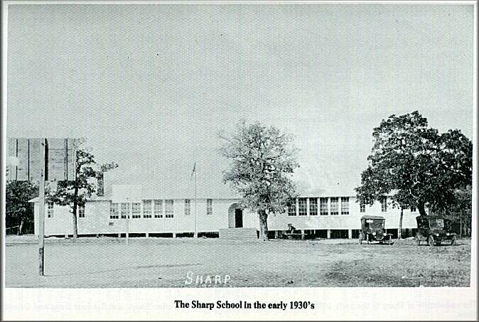
Shortly after the first church in 1872, a school was established. Dan G. Davis donated the land for the school. There have been several frame buildings to house the school. One was a two-story frame building. A fine brick building was completed in 1939, but unfortunately it was destroyed by fire before a day of school was conducted in it. Another one was built immediately on the same foundation. This is the impressive red brick building which is seen in Sharp today.
Sharp had the largest school district in Milam County, and one of the largest in the state, excluding the sparsely populated areas of West Texas. It covered an area of 75 square miles, and at one time had an enrollment of almost 500 pupils. It became a consolidated high school in 1931-32 and began work on accreditation. It soon became fully accredited.
As was trend of the times many people moved away from the rural areas to find employment in the cities. This district was no exception. The enrollment dwindled rapidly and in 1964 the Sharp Common School District consolidated with the Rockdale Independent School District.
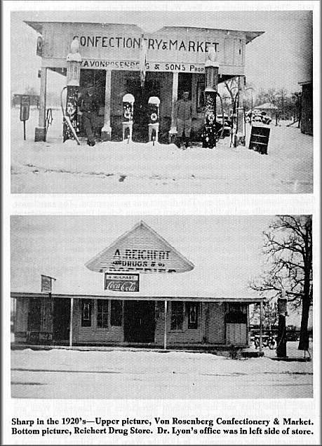
Large land owners contributed much to the development of Sharp. In 1896 at the age of 18, Will Davis built the cotton gin and the Davis store. Will Davis' son, Nelson, with his sons, Dan and Reed, continue to operate the farm, ranch and ginning business. Doris, daughter of Will Davis, and her husband George Triggs, have continued to run the store.
This store, gin, and the Harbuz garage are the only three business establishments that Sharp has in operation today. There was once a blacksmith shop; C. R. Campbell, J. B. Baldridge and John Hopkins were among the first store owners; then there was the Speigel Store, the Reichert Drug Store, Rosenberg Grocery, the Petty Garage, Hertenberger Garage, Stephen's Cafe, and the telephone exchange.
Dr. Lyons and Dr. Burns were two of the early-day doctors. Sharp had music and dancing in several halls. Three of them were:
Roseland Hall, Dinker Hall, and the Woodmen Hall. Mr. Ernest Backhaus and his band played in the years around 1915. At the age of 82 Mr. Backhaus is probably the oldest person living in Sharp today that has lived here for a long time. Jamie Clark and the Moonlight Serenaders and Lawrence Welk are musicians remembered to have played here.
During 1921-29 Sharp had fine baseball teams that created a high pitch of excitement for the community. In 1929 the Waco News Tribune sponsored a league that was won by Sharp.
SIPE SPRINGS
(Researched by Mrs. Ida Jo Marshall)
This is an agricultural community six miles southeast of Rockdale. It was named for natural springs nearby.
The school in this community was organized before 1892-1893. Records before this date were destroyed by fire. This school was consolidated with the Milano Independent School District in 1932.
TALBOTT RIDGE
(Researched by Ella Myrtle Caywood)
The community of Talbott Ridge is situated in central Milam County, north, northeast of Rockdale. In its beginning the community area began at the Rainbow Courts in Rockdale, extended east on Highway 79 to Sandy Creek and north on Highway 77 to near Minerva. Its sandy loam soil is ideal for vegetable and watermelon production.
In the early 1800's James B. Talbott with his wife, Martha, [eft fEngland for a new life in America. They landed in New Orleans and slowly made their way in covered wagons into Central Texas. Here on August 20, 1869, he purchased from a Mary F. Able three hundred acres of land that was a portion of the Jose Leal Spanish Land Grant. The hills and valleys were filled with deer and other game and fish in running streams. They and their children were soon joined in 1874 by the W. 1. Caywoods and the Jim Bullocks. Cotton was the principal crop. Several hundred acres were set aside for cotton production.
It was in 1895 that Mr. Talbott gave one acre of land on a ridge of his northern boundary which overlooked a valley. This one acre of land was to be for the School District No. 72 and the community was named Talbott Ridge in his honor. Mr. J. P. Marshall was hired as the first teacher at the salary of $40.00 per month with 83 students that grew at one time to 165 and included a Negro school taught by a Miss Julia Aycock in 1906.
The community grew and other farmers moved in. Some of the early families were the Vogels, Lorenzes, Leepers, Hansons, Witchers, Burgesses, Yoakums, Ingrams, Hills, Davenports, Ousleys, Robersons, McFaddens, Sanfords, Steinbergs, Hamils and many more.
Lignite coal was discovered in a small creek by Mr. Gus Vogel. This discovery brought a new era to Talbott Ridge. There were many mines opened. Some of these were the Compress, Big Lump, the Big Square, International, Vogel, Yoakum, the Texas, the Witcher and the Worley mines. Two of these were slope mines and cars of coal were pulled to the surface by mules. All this brought many more people to work the mines. The clay was fi~und suitable for brick and two brick kilns were started. One of these was started by Major Talbott and another by Vogel and Lorenz. Mr. D. Tannyhill found the clay ideal for pottery and set up his pottery wheel. Here many jugs, crocks, pots and churns were shaped and salt glazed a golden brown. Many workers were needed so the Mexican Nationals came bringing new foods, customs and happy music. They built a village of their own near the company "Big Store" where the Talbott Ridge road enters Highway 79.
Now there are no coal mines, no brick kilns, no pottery wheel, nor is there a school at Talbott Ridge. Students attend the Rockdale Schools through consolidation of the districts. Farming has almost gone the way of other occupations. Cattle raising has taken the lead. Land has been cleared of the tall trees and coastal grass affords food for pastures. The deer have moved farther south and east. Lakes and ponds have taken the place of the "ole fishing hole."
Time and progress have taken their toll and only the Lee Caywood family remains of the original settlers. New homes have replaced old ones and young families have started a new era of their own with hopes of another 100 years of better things for Talbott Ridge.
TRACY
(Researched by Mrs. Mabel Charles)
Tracy is a rural community ten miles northwest of Rockdale. It was named for Nat Tracy, an early land owner in Milam County.
People's Atlas of the World, c1894, has a map of Texas published in 1890 which shows Cameron, Rockdale, Thorndale, Milano, Gause, Baileyville, Branchville, Davilla, San Gabriel, Lilac and Leachville in Milam County.
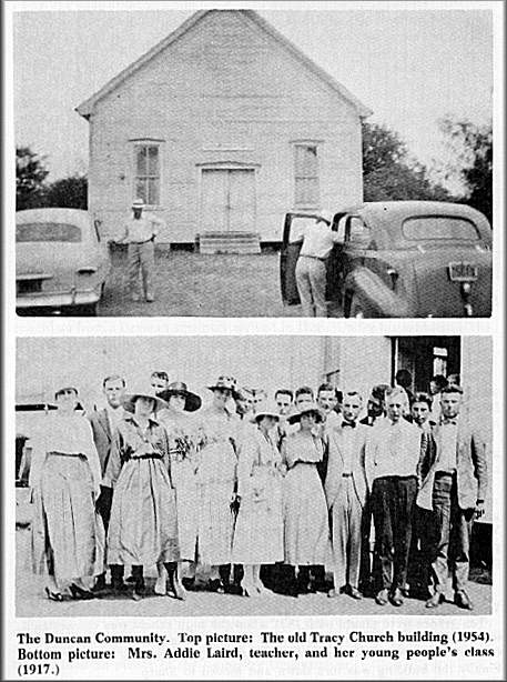
Leachville was a big school about two miles west of Tracy. A small Leachville, No. 2, was south near the San Gabriel River. The late Mrs. Addie Laird who was then Miss Addie Schulz, taught forty pupils there between 1892 and 1896.
At the turn of the century Tracy was a thriving community with two stores, blacksmith shop, a cotton gin, a school, a two-story Woodmen of the World Hall, a doctor's office, drug store, and three churches: namely, Methodist, built in 1899, Baptist, and Christian.
There was an oil boom for a few years prior to 1920.
Tracy High School was consolidated with Sharp in 1931, and the other grades in the mid 1940's. In the 1960's Sharp consolidated with the Rockdale Independent School District. Now the students are bussed to Rockdale.
A county precinct voting box No. 29 was located here until the early 1960's. Now Tracy citizens go to Sharp to vote.
The gin burned in 1940's. A number of homes in the community have been destroyed by fire through the years.
The Methodist Church is the only surviving building now serving the community. The Sunday School has been continuous since its beginning. The Methodist Church has never been without a pastor. The Reverend Perry D. Richardson of the First United Methodist Church of Cameron is in the pulpit at 9:00 a. m. each second and fourth Sunday each month. Sunday School is held at 10:00 a. m. each Sunday.
WATSON BRANCH
(Researched by Mrs. C. L. Yount)
In the southwest part of Milam County Mr. William Patton Pritchard donated land for a church to be built where all denominations could come and worship. This was Union Church, and the earliest records available are from the year 1891. The Reverend J. A. Stephens was pastor that year.
Early deacons of the church were: D. S. Todd, N. H. Scales, H. Poe, J. S. Brady, B. W. Rhodes, W. F. Scales, and T. J. Wauson. Mrs. Alice Poe was church clerk for many years.
In 1902, Mr. and Mrs. T. J. Barber gave land near the Watson Branch school for this church. In 1903 the old building was torn down and rebuilt at this new location which was two and one-half miles from its first locations.
This church joined the Baptist Association in 1919 or 1920.
The church building was destroyed by fire in 1948. A vacant house was used for a time. Later the school board gave the school building and the grounds to the church to be used as long as it would be needed. Sunday School and preaching services are still being held in this church regularly.
Watson Branch, a one-room school, was on the banks of Wauleye Creek in Southwest Milam County. It was located on land owned by Mr. and Mrs. Andrew Jensen.
The date of the beginning of this school is unavailable, but it was probably some time before 1900.
In 1916 Mr. and Mrs. T. J. Barber donated four acres of land when a new two-room school building was erected.
This school building was destroyed by fire in 1948. Then a building was moved here from Camp Swift and used as a school building. In 1950 the school was consolidated with the Thorndale Schools; consequently, the school building and grounds were deeded to Union Baptist Church.
Return To: History of Rockdale TX Table of Contents
Return To: Milam County, Texas Archives
Copyright 1996-Present USGenWeb Archives Project