
COPYRIGHT INFORMATION
LANE LAND TRACT
OWNERSHIP PLOT MAPS
Barbara Wentz, Cartographer
Eleanor Mayfarth, Deed Records
2003-4 Project for Mandy Helwig in her [futile] attempt to save the
Collegeville Dam.
1683 - 1701 PRE "LANE LAND TRACT PATENT" HISTORY
All descriptions of
the Land that was to become the Lane Tract are as reported by Williams,
"St. James Church, Perkiomen, Evansburg"8,
pp. 350-354 from his study of original papers, including survey map
graphics, Phila. Co. Patent Book A Vol. 2:175, and others.
1684-1685
12th day
4th month, 1684 Wm. Penn issued a warrant for the survey of
4,400 acres of land for Thomas Rudyard in the County of
Philadelphia and 1200 acres in "Newton Township in the
County of Cheshire."
[Newtown, Chester
Co.] Andrew
Robeson purchased 2,500 acres of the land in Philadelphia
Co. from Rudyard July 15, 1685.
1692/3 Penn's agents issued a warrant
11th
day of Feb., 1692 (/3) for "the remainder of Andrew's
land purchased from Thomas Rudyard" to be
surveyed.
1694
Andrew Robeson's will written 12 Nov., 1694, proved 24 Dec.,
1694 left his estate to his wife Elizabeth. [Codicil 14 Nov., 1694
left a legacy to nephew Andrew Robeson of West Jersey, who moved to Berks
Co. and was the father-in-law of Eleanor Robeson, dau. of Edward
Lane.] Thomas Fairman did the survey and
made his report 12th
day of 12th mo. 1694/5. His report showed the location of the land. This
survey was registered in Office of the Surveyor General 11
th day, 12th mo., 1698/99.
The map of the survey is shown following page 354 Williams.8
(Phila. Co. Will Book A:286: Andrew Robeson)
1698/9 Prior to his death Andrew had agreed to convey
this tract to Thos. Fairman. The latter thereupon sold his
right to purchase to Edward Lane. Samuel Robinson, heir
of Andrew, then joined with Thomas Fairman in a deed to
Edward Lane, dated the 12th day of the
9th month.
LANE TRACT MAP #1
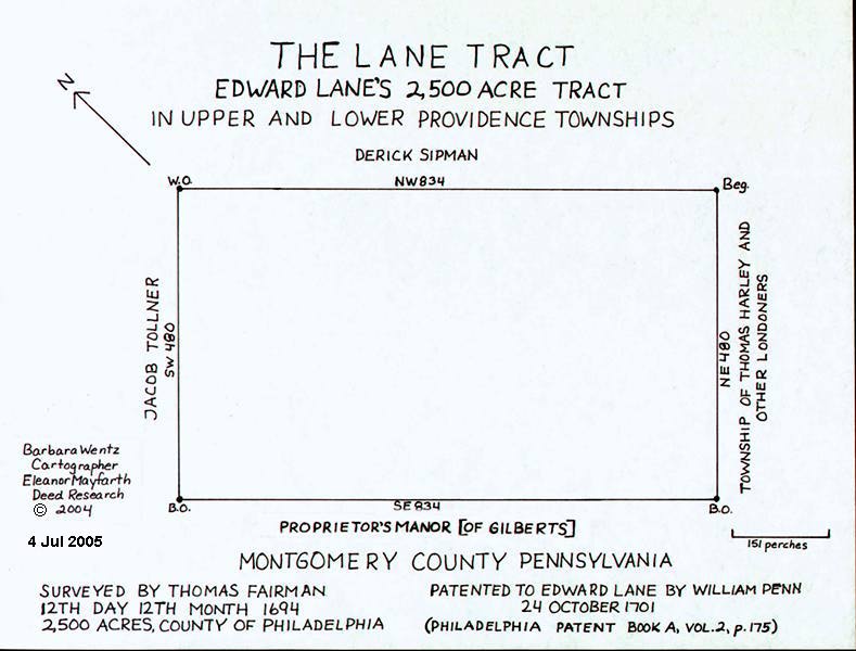
THOMAS FAIRMAN'S 1694
SURVEY
1701-1710
1701 Edward Lane was granted 2,500 acres in Providence
Twp. 24th day of October,
1701, by Wm. Penn.
(Phila. Co. Pat. Book A Vol. 2 page 175)
Note: At
some time during this period Edward Lane apparently gave land to St. James
Church. There is no extant deed from him nor his executors ceding land to
St. James Church, nor a bequeathal in his will that includes land to
it. There is evidence of a plot of land belonging to St. James prior to
1718 when his son William came of age, and no evidence of William ceding land
to St. James prior to the gift of additional land to St. James in his
1732 will. As Providence Twp. was not formed until 1725 some of
the later deeds and wills of this time frame are listed as nearby Skippack
Twp.
The acreage was over 2,500 acres when actually laid out. Williams
describes how this land was described several years later: "It was a
simple rectangular tract 480 perches wide by 834 perches long, and the
joiners on the respective sides were as follows: On the north
east by land of Dirck Sipman; on the north west by land of Jacob
Tolldner & Co.; on the south west by land of the Proprietors
Manor on the Perkiomen [the London Company's Manor of Gilbert]; and on
the south east by Tho. Harley's land. The Sipman
land is the VanBebber land subsequently purchased from Sipman by
VanBebber, and now forming a large part of the townships of Skippack and
Perkiomen."
Just beyond Edward Lane's holding and immediately joining him was the tract
of Matthias Van Bebber, commonly known as "Bebber's
Township". In the patent to Van Bebber's survey the first call in
the description is as follows: Beginning at a hickory sapling
at the corner of Edward Lane's, and, from thence by a line of marked trees
north east, &c'. until we come to the last clause then it reads
"then south east by the said Edward Lane's land 900 perches to a hickory sapling, the place
of beginning." This is probably the same hickory sapling referred to by
Fairman in the original survey.
(Williams8 pp.
350-354)
LANE TRACT MAP #2
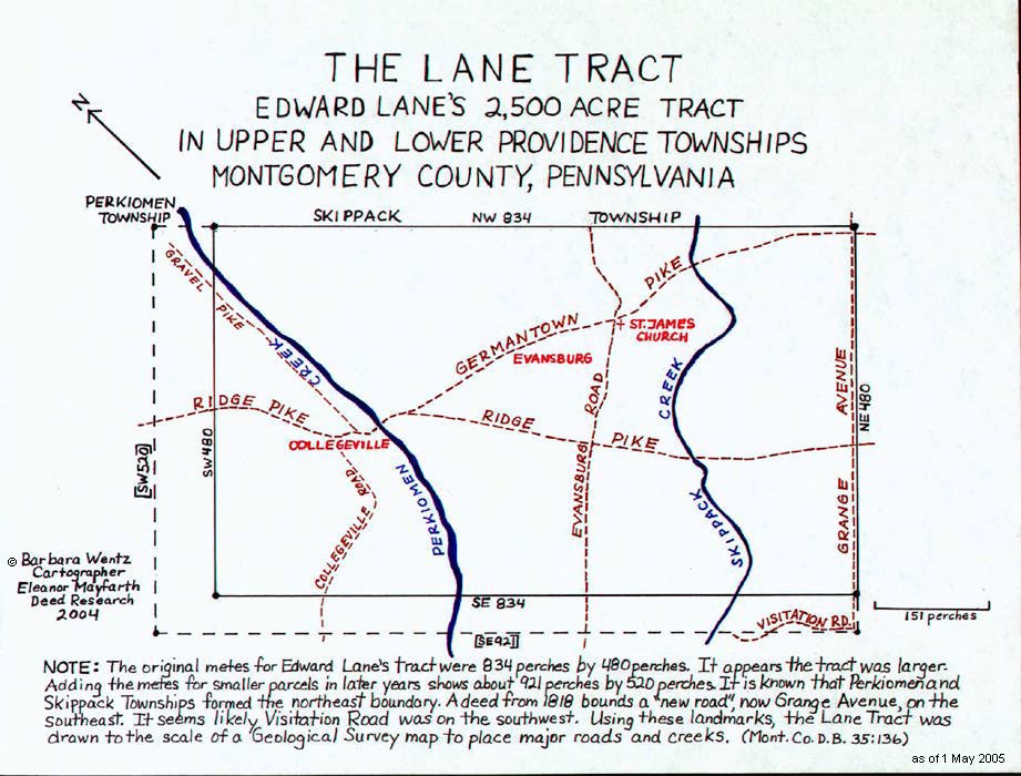
OUTLINE OF THE LANE TRACT WITH 2005 LANDMARKS
LANE TRACT MAP #3
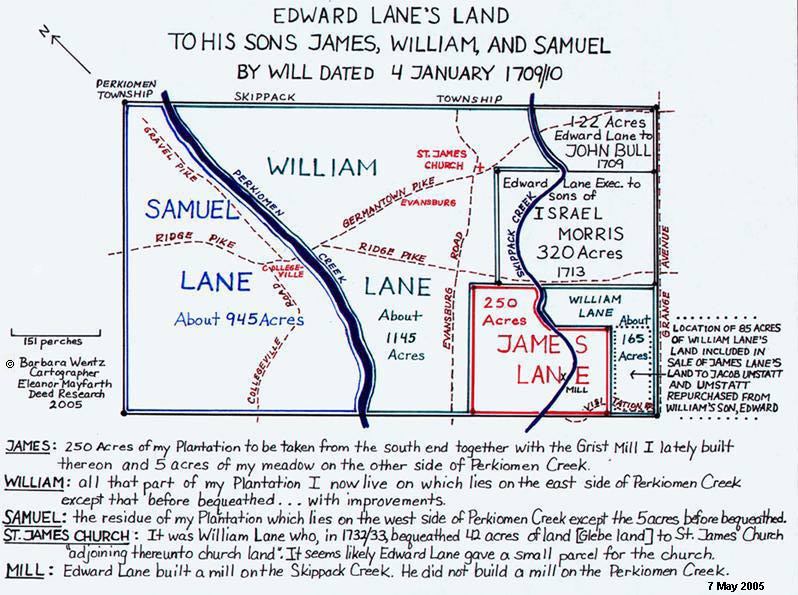
EDWARD LANE TO SONS, ALSO TO
ISRAEL MORRIS AND JOHN BULL
Reference and Notes [See
Will of Edward Lane, 1709/10]
LANE TRACT MAP #4
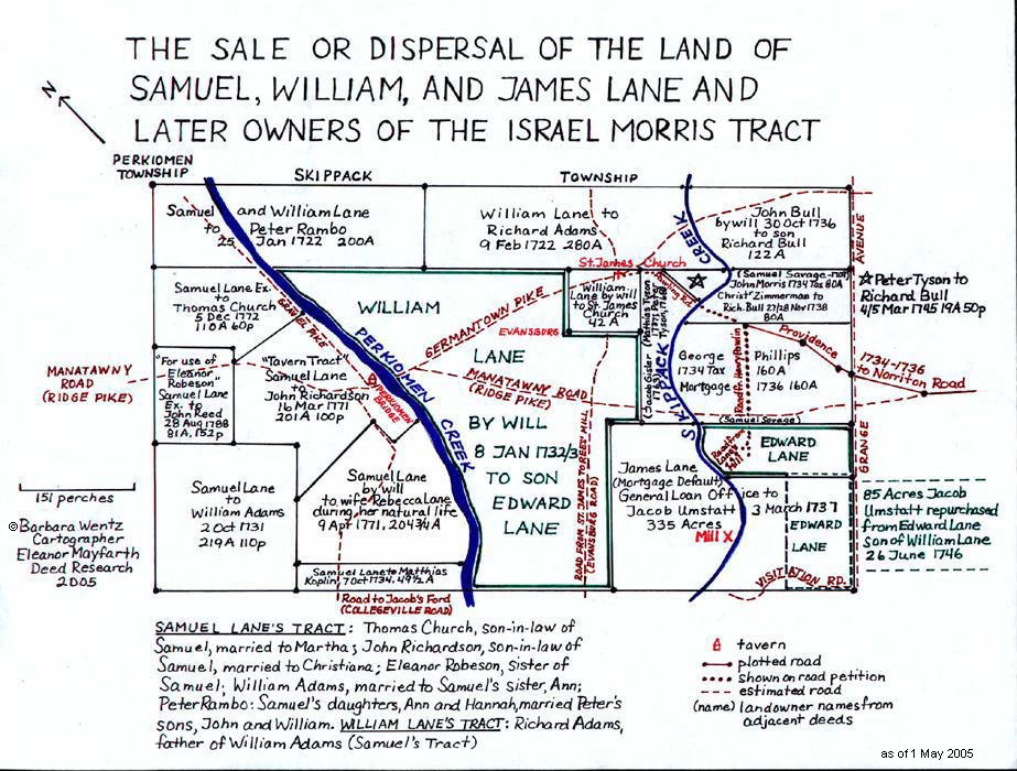
SALE OR DISPERSAL OF LAND OF EDWARD LANE'S SONS, ALSO ISRAEL MORRIS TRACT
Reference and Notes
LANE TRACT MAP #5
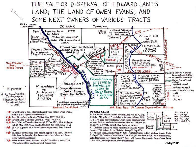
SALE OR DISPERSAL OF THE LAND OF EDWARD LANE [SON OF WM.] AND LAND OF
OWEN AND ELEANOR [LANE] EVANS, ALSO SOME NEXT OWNERS OF VARIOUS TRACTS
Reference and Notes
LANE TRACT MAP #6
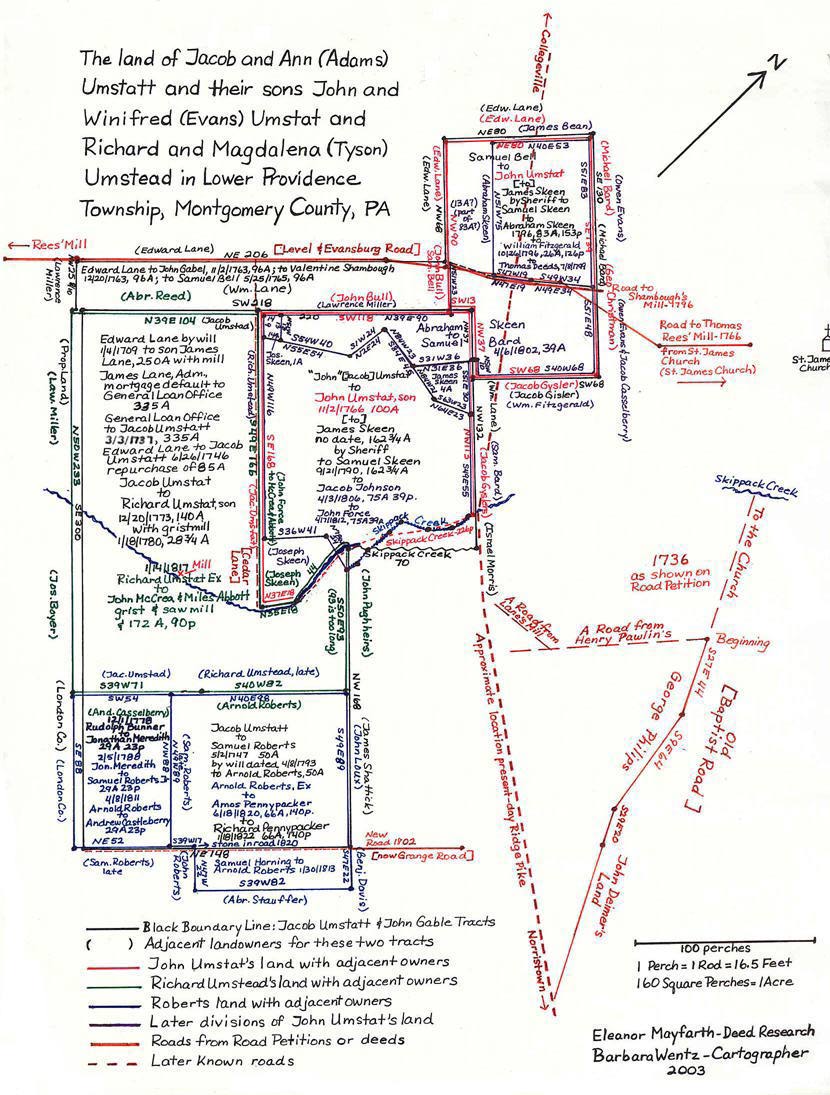
SALE OR DISPERSAL OF THE LANE LAND OF JACOB UMSTATT
Reference and Notes
Return to St. James Introduction
Return to 1790 Pew Holder's Chart
This page updated Saturday, 12-Aug-2023 05:54:58 EDT
You are our
 visitor.
![]()


visitor.