Pennsylvania USGenWeb Archives

Clearfield County


Copyright

Search

Contribute


Home · Bibles · Biographies · Cemeteries · Census · Court · Deeds · History · Military · News · Obituaries · Photos · Tax Lists · Tombstones · Vitals · Wills


Clearfield County Pennsylvania

Present and Past


by

Thomas Lincoln Wall

Ex-Supervising Principal

Boggs Township Schools


Library Edition

Published by Author


Copyright 1925

by

T. L. Wall


Transcribed for the Clearfield County PAGenWeb Project by

Ellis Michaels


 Chapter 16

Pages

233

234

235

236

237

238

239

240

241

242

243

244

245

246

247

248

249

250

251

252

253

254

255

256

257

258

259

260

261

262

263

264

265

266

267

268

269

270

271

272

273

274

275

276

277

278

279

280

281

282

283

284

285

286

287

288

289

290

291

292

293

294

295

296

Clearfield High School

Clearfield Academy


printer friendly version of this page


233

CLEARFIELD COUNTY - PRESENT AND PAST


CHAPTER XVI


Local Divisions of The County.


BECCARIA TOWNSHIP


     Beccaria is bounded on the north by Chest, Jordan and Bigler, on the east by Bigler and Gulich, on the south by Cambria County, and on the west by Jordan and Chest.


     Within it are the boroughs of Coalport, Irvona and Glen Hope.
 

     Clearfield Creek crosses the township and Muddy Run, one of its branches is on the east boundary. The Pennsylvania Railroad crosses the southwestern part, and the New York Central connects the township with the County Seat. There are good farms in the township, also mines of coal, so that farming and mining are the principal occupations.


     People. The population is nearly 4,000. There are a number of small towns among them being Utahville, Rosebud and Blaine City.


     The McCrees, Carsons, Hagertys, Gills, Dillens, Leonards, McNeals, Ricketts and Smileys seem to have been early settlers, also Dr. Keaggy, who was one of the first doctors and also a preacher. John Gill mined coal in 1810 and used it for blacksmithing. In 1813 a road was opened across the mountain to Tyrone, over which long-lap shingles were hauled to Birmingham and sold. There are numerous churches in the inclosed [sic] boroughs.


     Schools. Beccaria has a High School at Utahville and


234

CLEARFIELD COUNTY - PRESENT AND PAST


graded schools at Blaine City, Rosebud, New London, Lylevine and Beccaria, besides there are seven one-room country schools. There are nearly 1000 pupils in all. The schools are under the care of a supervising principal.


BELL TOWNSHIP, MAHAFFEY BOROUGH AND
GREENWOOD TOWNSHIP


     Bell is bounded on the north by Brady and Greenwood; on the east by Penn, Greenwood, Newburgh borough and Chest; south by Burnside, Newburg and Chest.


     The river crosses the southern part and Chest Creek flows into the river at Mahaffey. Other streams are Clover Run, Whisky Run,Deer Run, Miller Run, Laurel Run, Haslet Run and Curry Run. There is good farming land in the township, also coal. It was once a great country for timber. There are the New York Central and P. R. R. Railroads.


     People. The Population of Bell township is about 1500. Of Mahaffey around 800. Greenwood around 500. Farming and mining are now the principal occupations. There is a tannery at Mahaffey, but it is likely to be dismantled soon. Mahaffey is quite a railroad center, with a large number of trains passing through every day. The state highway towards Pittsburgh and connecting east with the Lakes-toSea Highway is being paved through the two townships and borough.


     Early Settlement. Johannes (John) Ludwig Snyder, though buried in the New Washington cemetery, seems to have been the pioneer of Bell Township, settling on Chest Creek about 1820. He was a Revolutionary soldier. John Smith, who came about the same time, built the first school house about 1827 or 28. His improvement was on the site of the hamlet of Bethlehem. Others were the Sunderlins,


235

CLEARFIELD COUNTY - PRESENT AND PAST


Weitsels, McGees, Johnstons, Weavers, Campbells, and Ellises. In 1831 Nathaniel Sabins made an improvement where Mahaffey now stands. Sabins was a great hunter.


     William Ramsey built a sawmill and later a woolen or fulling mill on Chest Creek on the site, later, of Mahaffey's grist mill. This venture was not altogether successful, so he changed the fulling mill into a grist mill. He built the first frame house in this section.


     Bell township was named after the Bells, though most, if not all who lived within the former limits of it, were taken into Greenwood township when it was organized in 1875.


     Robert Mahaffey was the founder of the town of Mahaffey, having purchased the land here in 1841 or 42, living for 25 years in the log house he built at that time. Prior to the building up of the town, the place was called Franklin by Mr. Mahaffey.


     McGees or McGees Mills is a small town at the mouth of Bear Run, first settled by Rev. James McGee in 1826. Many of his numerous descendants are yet living hereabouts.


     In 1833 a mail route was started between Curwensville and Indiana and at this point a post office was established, called Chest, and James McGee was made postmaster. Later the post office name was changed, but the postmaster- ship remained in the McGee family for many years.


     The pioneer church is the Methodist Episcopal, in the upper part of the township in the Sunderlin neighborhood. It was built in 1860.


     Greenwood township is bounded on the north by Penn, on the east by Penn and Ferguson, on the south by Bell and Ferguson. The river crosses it, the other principal streams being Haslett Run, Curry Run and Bell Run. The New York Central River and Beech Creek Lines intersect at Curry Run and cross the township. The river bottom is good farming land, also some of the ridges.


236

CLEARFIELD COUNTY-PRESENT AND PAST


     The hills are underlaid with coal. Bells Landing, Curry Run and Bower are villages along the river. Lumbering was formerly the principal industry.


     Greenwood Bell after whom the township was named, and William Haslet, who came in 1828, were probably the pioneer residents in the territory that afterwards became Greenwood township. Dr. John P. Hoyt, who was very active in getting the township organized, came in 1846 and built Hoyt's Mills on the river. Other early settlers were the McCrackens, Thompsons, Youngs, Passmores, Kesters, Hulihans, McLaughlins, Rowleses, Robinses, Thorps, Mitch- ells, Tates, Henrys, Hoovers, Rosses, Wileys, Smiths, Currys, Johnstons, Johnsons and others.


     There was for many years a woolen factory at Johnsons. There are churches at Bells Landing and Curry Run.


     Schools. Bell township has nine one-room mixed schools and two schools graded into grammar and primary. There are thirteen teachers and about 350 pupils.


     Mahaffey has a High School and four grade rooms with eight instructors in all and around 200 pupils. Greenwood township has five one-room mixed schools with about 125 pupils.


BIGLER TOWNSHIP


     Bigler, the youngest township, is bounded on the north by Jordan, Knox and Woodward townships, on the east by Woodward and Gulich townships, on the west by Knox, Jordan and Beccaria townships, south by Beccaria and Gulich townships.


     Clearfield Creek crosses, and its branches drain the township.


     The Pennsylvania and New York Central Railroads cross it. There are great deposits of coal and the land is generally good for farming, except along the sides of the creek hills.


237

CLEARFIELD COUNTY - PRESENT AND PAST


     People, Churches and Schools. The population is more than 4500. Madera is not a borough, but has a larger population (about 1800), than many of the boroughs in the county. Fires have nearly wiped out the town at different times. Other towns or communities are Belsena, Amesville and Banion.


     There are a number of Churches of the different denominations in the township.


     The schools have an enrollment of over 1300 between six and sixteen. There is a High School at Madera with four instructors including the principal. The building also houses the grades with eleven teachers.


     There are three other graded schools and nine one-room mixed schools, with sixteen teachers in all, outside of the town making an entire teaching force of thirty-one in the district.


     There are (1925) over 400 pupils in the Madera schools, of whom 131 are in High School. A course of study is outlined for Madera schools.


     Settlement and Organization. Bigler Township is in historic country. An Indian burial place was here,—remains having been found in different places near Madera. There was an Indian trail from the Juniata river near Cold Spring, passing through Three Springs Gap, then to the extreme head waters of the Moshannon on Tyrone Mountain, then up Moshannon a few miles in a nearly direct line to and down Muddy Run to its mouth about one-fourth mile above Madera, then up the creek to the "Oxbow". Here is where Capt. Edward Ricketts made a small clearing and built a cabin, as early, some say, as 1797. Others put the date earlier. He brought his family about 1801. His daughter, the wife of Scholey Scott, is said to have been the first white woman born in this part of the county. James Alexander left a pint of apple seeds with an old hunter who planted them in 1800. Some of the


238

CLEARFIELD COUNTY - PRESENT AND PAST


trees are still living near the Hagerty Mill. The first cabin stood on Alexander run.


     The early settlers were the Alexanders, the Hagertys, Shoffs, Puseys and others.


     Madera, or the part on the west side of the creek, was formerly called Puseyville, after Charles Pusey, a lumberman of the community.


     William R. Dicliinson is said to have owned the first logs run on the creek. They were destroyed by the timber men who thought logging interfered too much with the running of rafts. The Kellys were also interested in the struggle over the right to float logs down the creek.


     Bigler township was organized from parts of Woodward, Beccaria, Knox and Gulich townships in 1883.


BOGGS TOWNSHIP AND WALLACETON BOROUGH


     Boggs township is bounded on the north by Bradford, Lawrence and Graham townships (and surrounds Wallace- ton borough on three sides) on the east by Bradford, Graham, Morris and Decatur townships, on the south by Decatur and Woodward townships, on the west by Lawrence township. Clearfield and Little Clearfield Creeks form most of the boundary on the west and the other principal streams are Morgan Run, Long Run, Laurel Run and some other small streams.


     The surface in general is hilly and rough, but there is some good farm land and a few good farms. The township was formerly well covered with timber, and a good young second growth is coming on and will eventually be of much value if fire is kept out.


     There are valuable deposits of coal and fire clay.


     The Pennsylvania railroad passes through the township, as does also the Lakes-to-Sea Highway and as did the Erie Turnpike and the old state road.


     The town of Blue Ball, in the extreme eastern end, contains more than half the entire population of the township.


239

CLEARFIELD COUNTY - PRESENT AND PAST


Here is located the brick plant of the General Refractories Company, whose mines of coal and clay, and brick works give employment to most of the population of nearly 1000.


     The total population of the township is something less than 2000


     Schools. There are about 500 school children, of whom more than half go to Blue Ball School, a four-room brick building, built in 1911, but now much too small for best results in school work. There are also six one-room mixed schools in different parts of the district. The schools have been put upon a good working basis, but need better housing.


     There are two voting precincts, Blue Ball and Stoneville.


     The township, organized in 1838, was named after Judge Moses Boggs.


     Some of the early settlers were the Shimmels, Abraham Hess, Abraham Litz, Samuel Turner, Andrew Kephart, Jacob Haney, George Wilson. Alexander Stone built a tavern at Stoneville on the Erie Pike in 1820. There were also taverns on the pike at Blue Ball, Brealer's, Albert's, Robison's and Lumadue's.


     Blue Ball seems to have derived its name in some way from the sign of the blue ball, either at the old tavern here, or adopted by John Frazier, who coming from Blue Ball in Lancaster county, located here in an early day.


     There are a number of churches in the district, including Salem, one of the oldest United Brethren organizations in the county.


     The United Brethren have lately built a new church building in Blue Ball. The United Brethren and Methodists have Sabbath Schools with an attendance of over 100 each.


WALLACETON


     The Pennsylvania and New York Central Railroads pass


240

CLEARFIELD COUNTY - PRESENT AND PAST


through Wallaceton and the Lakes-to-Sea Highway is on the outskirts of the town.


     The town has a brick plant, feed mill, a number of stores, two churches, and a school of two rooms and about 60 pupils.


     The population is about 250.


BRADFORD TOWNSHIP


     Bradford Township is bounded on the north by Lawrence, Goshen and Girard townships, on the east by Graham, on the south by Boggs and Graham townships and Wallaceton borough, the river is on the north and Clearfield Creek is on the west. Roaring Run, Millstone Run and Moravian Run are the other streams. There is good farming land in the township.


     There are deposits of fire clay and coal.


     The Pennsylvania and New York Central Railroads extend through the township from Wallaceton to Clearfield Creek, as does also the Lakes-to-Sea Highway.


     The Indian path crossed the township.


     People and Industries. More than two-thirds of the people live in the towns of Bigler, Woodland, Mineral Spring and Barrett, there being brick plants at each of these places.


     The population is over 2500.


     In addition to the brick-making industry, the people are engaged in mining and farming. Lumbering was formerly an important industry.


     There are a number of country churches besides those in Woodland and Bigler.


     Schools. There are nearly 700 pupils in the district. There are seven of the ten rooms occupied in the new consolidated school at Woodland and two rooms at Bigler. The other pupils are provided for in eight one-room buildings in different parts of the township. A supervising principal is employed. There is little record of the early schools in


241

CLEARFIELD COUNTY-PRESENT AND PAST


Bradford, though Samuel Waring, school master, brought in a bill in 1822 for having taught three poor children. It is not certain that his school was within the present limits of the township.


     Early Settlement. Robert Ross and family settled above the mouth of Trout Run in 1812. The Forceys came in 1813 or 14, the Grahams seem to have come to eastern Bradford about 1811, the Hoovers, Turners, Hurds, Dales, Kylers, Pierces, Woolridges, Shireys, Wilsons, Stewarts, Graffiuss, Purges and Dixons were all early settlers. Besides these, there were two colored families, Adam Myers with only adopted children and Caesar Potter and his wife and family.


     The township was organized in 1807, being one of the first to be taken from Chinklacamoose, but its size has since that time been much reduced to form other townships.


BRADY TOWNSHIP AND TROUTVILLE BOROUGH


     Brady township is bounded on the North by Sandy township, on the east by Union, Bloom and Penn townships, on the south by Bell and Penn townships and on the west by Sandy township and Jefferson county. It entirely surrounds Troutville borough.


     The surface is hilly and picturesque as a landscape, but not rugged or barren. There are elevations of two thousand feet or over.


     Its drainage is nearly all towards the Allegheny river, though Anderson Creek heads in Brady. There are no large streams.


     Brady Township produces more farm produce than any other township in the county. There is also much coal mining.


     The Buffalo, Rochester and Pittsburgh, and the Buffalo and Susquehanna railroads and the trolley line between DuBois and Punsxutawney cross the township.


     The Lakes-to-Sea Highway traverses it, for much of the


242

CLEARFIELD COUNTY - PRESENT AND PAST


way on the line of the Erie pike. The old state road crossed Brady diagonally from south-east to north-west.


     The majority of the people are of Pennsylvania Dutch descent, are sturdy, reliable and good farmers. The principal occupations now are farming and mining. Formerly it was lumbering. There are about 2500 people.


     Schools. A few years ago Brady took a step forward in educational matters and employed a supervising principal.


     There are (1924-25) over 600 pupils in the district in sixteen school houses, with twenty-two teachers. Of the pupils, sixty are in High School and 563 in the grades. Average attendance 540. The average cost of schooling per pupil per term is $34. A monthly outline of work for pupils is made by the supervising principal.


     Whitson Cooper seems to have been the first teacher. He "kept school" in his log house, built on land of Major H. M. Luther, in Luthersburg in 1823-4.


     School was often taught in Lebbeus Luther's bar room, which seems to have been the general meeting place of the people for any and all purposes. Rev. Anderson first preached in Luther's bar room in 1822 or 23.


     Early Settlements. James Woodside seems to have been the first settler in 1785 or soon after that date. A monument has been erected to his memory at Luthersburg. He lived by himself or with only Indians for neighbors for many years,until Joab Ogden came about 1807. They lived on Stump Creek, Woodside, where Helvetia now stands, and Ogden a mile further down, where Carlisle Station now is. In 1820 Lebbeus Luther, from Massachusetts, located on a tract of land including the place where Luthersburg now stands, the town having since been named after him. Luther was land agent for Fox & Co. who owned thousands of acres in this vicinity. The first tract sold was to Benjamin Bonsal, who


243

CLEARFIELD COUNTY - PRESENT AND PAST


came from Perry county in 1824. Frederic Zeigler came from York county about the same time and settled on the old state road (and Indian path) at the Big Spring, one-fourth mile south of Luthersburg. Later this was called the Thompson place. John Carlisle from Lebanon county, came about 1828 or 29, settling at what is now known as "Goodlanders". In 1830 Jacob Kuntz came from Bavaria, Germany, and settled near where the Reformed church now stands. The first post- office in Brady was kept by David Irvin at Luthersburg, on the completion of the Erie Pike, in 1824.


     Among the others who came a little later were the Knarrs Weisgarbers, Wingerts, Korbs, Yoases in 1831, Jacob Trautwein (at Troutville) in 1832, and Henry Goodlander in 1837. Some of the early settlers were "squatters", that is they came and holding peaceable possession for 21 years acquired title. Matthew Irvin had the first store in Luthersburg in 1835.


     The road from Luthersburg to Troutville (nearly on the old Indian path to Punxsutawney) was a community enterprise, being opened by the volunteer labor of the settlers in 1831.


     The first grist mill in the township was Joab Ogden's, the bolting cloth of which turned by hand. John Carlisle once took a grist to this mill and undertook to grind it himself, which he did, but when done, could not stop the mill!


     Game was so plentiful that Adam Knarr once counted 40 deer in a four acre field. Frederic Zeigler shot over 600 deer in his time, then lost count, but killed many more. He also shot and captured 82 bears. "Uncle Billy" Long was a noted hunter, as was Joab Ogden.


     There were also panthers and wolves. Once when Mrs. David Haney was at home alone (the cabin had only a blanket for a door) the wolves came and attacked the cattle but she scolded them so vigorously that they fled.


     At another time when on the way to a neighbor's house,


244

CLEARFIELD COUNTY - PRESENT AND PAST


she met a panther, which lowered its tail and crouched as if ready to spring upon her, but she again scolded it so severely that it turned tail and leaped away.


     The Carsons located west of Luthersburg in 1814. Joseph Packer came soon after. He bored for salt at Luthersburg, but found none.


     Troutville. Troutville has a population of less than 300. It has a number of stores and a feed mill. It is in a good farming community and. is on or near where the old Indian path went to Punxsutawney.


     There are two churches and a grange.


     The school has two rooms, grammar and primary. There are about seventy pupils and two teachers.


     The Knarr hewed log house was the first. It had a clay floor tamped down on a log bottom, no second floor, and with the apex of the clapboard roof open to let the smoke out.


     Township and Borough Organization, Etc. Brady Township was organized in 1826. Troutville in 1854. Brady has numerous churches. The Sabbath Schools were Union until 1872, having been so organized at first in 1833 or 34. There were and still are a number of orders and lodges, including granges at Faudie and Salem. The people love music and by organized singing societies and bands have kept up interest in frequent meetings.


BURNSIDE TOWNSHIP, BURNSIDE AND NEW WASHINGTON BOROUGHS


     Burnside township is bounded on the north by Bell township and New Washington borough, on the east by Newburg and New Washington boroughs and Chest township, on the south by Cambria county and Burnside borough. The river extends through its whole length north and south and with its tributaries and those of Chest Creek drain the the township. The greater part of the township is a north


245

CLEARFIELD COUNTY - PRESENT AND PAST


and south ridge between the river and Chest Creek. The New York Central and the Pennsylvania are the only railroads.


     There are good farms on the ridge and along the river and creek bottoms. Farming and mining are the principal occupations.


     People. In Burnside township there are about 1300 people, in Burnside borough over 400 and in New Washington borough less than 100.


     The first settler was James Gallaher, who settled in 1816 on the present Cummings farm in New Washington. Caleb Bailey came in 1820, settling for a short time two miles east of Burnside.


     George Atchison settled on the river bank above Burnside in 1820. He was an Irishman and when quite young, shot some game on a gentleman's estate in Ireland and to avoid trouble, he came to America. He married in Center county and later brought his wife and one child to his new home in the wilderness, often going back to find work, bringing provisions on his back when he came home, for the family.


     Later when he built his fine large house on the hillside, he had a secret room constructed in which he hid runaway slaves, for his place was a station on the "underground railroad."


     Reeder King ran the first raft down the river all the way from Cherry Tree. John Ludwig Snyder, born in Ludwig, Germany, in 1746, died in 1860, aged 114 years, the oldest man that ever lived in the county. His wife was 105.


     Other settlers were the McKeehans, Byers', Lees, Riddles, Fultons, Westovers, Rorabaughs, Mitchells, Huttons, Kings, Neffs, Bairds, Youngs, Smiths, Breths, Patchins, Darrs, Yinglings and others.


     William Mahaffey was the first settler in Burnside borough, in 1827.


246

CLEARFIELD COUNTY - PRESENT AND PAST


     Hewed log churches were built at New Washington and Mt. Zion in 1837 and 1835. These have been replaced and there are a large number of other churches in these districts.


     Schools. In Burnside township there are nine one-room mixed schools and one graded school, grammar and primary. There are nearly 400 pupils in the district. In Burnside borough there are 35 high school pupils, 18 grammar, 30 intermediate and 35 primary pupils. In New Washington there is now one small mixed school. New Washington was formerly quite a center of learning, pupils coming here to Summer School from many sections of the county.


Organization. Burnside township was organized in 1835 New Washington in 1858 and Burnside borough in 1874.


CLEARFIELD BOROUGH


     Clearfield, the largest borough in the county, and the oldest, having been incorporated in 1840, is situated on both sides of the West Branch of the Susquehanna river, in the central part of the county. It originally included only that part of the present borough located on the east and south side of the river, but later the borough of West Clearfield was united with it. The town was named, as was the county, from the "cleared fields" that were here and in other nearby localities from and before the time of the first white settlement. It is, in general, well built and beautifully situated, extending along the river for nearly two miles.


     A Good Location For Business. The position of Clearfield for business purposes, is very good, having three railroad systems coming together at this point. The Pennsylvania, giving transportation facilities toward the east, and west as far as Grampian; the New York Central, extending up and down the river and to other sections of the county and farther, and the Buffalo, Rochester and Pittsburgh, extending to Du-


247

CLEARFIELD COUNTY - PRESENT AND PAST


Bois and to Buffalo, Rochester, Pittsburgh and other cities. The Pennsylvania Railroad was the first to enter the town, and came in February 1869. The Lakes-to-Sea Highway passes through the town and gives added business and social facilities.


     There are three banks, two first class and a number of smaller hotels, three railroad stations and a large number of garages and supply stations in the town. It is the terminal of the Fullington Bus Line, which operates busses to and from three sections of the town and also to Philipsburg, Tyrone and intermediate towns along the Lakes-to-Sea Highway. It is also the eastern terminus of the Edwards Bus Line, operating west on the Lakes-to-Sea Highway to DuBois, through Curwensville, Grampian and other towns.


     Industries, Etc. There are a number of manufactories in Clearfield, including a planing mill, four brick plants, machine shops, tannery, refrigerator works, silk plush mill, knitting machine factory, flour and feed mills, two or more ice cream factories, milk depot, four large bakeries, and seven printing establishments, one of which makes and handles school supplies on a very large scale. There are two department stores, several chain stores and a large number of other stores, both wholesale and retail. The assessed valuation of all property in Clearfield is over $3,570,000.


     Clearfield is in communication with the outer world by means of the Bell, and Huntingdon and Clearfield telephones, the Western Union, The Postal Telegraph and Cable Company, and by a number of private radio receiving outfits. The post office does more business than any other post office in the county.


     The Penn Public Service Company furnishes steam heat for many houses, from a central plant, and furnishes the town and its people with gas and electric light and power, while the


248

CLEARFIELD COUNTY - PRESENT AND PAST


Clearfield Water Company supplies pure water for all purposes. Clearfield has one of the finest parks in the state.


     The history of heating, lighting and power is contained in the chapter on that subject covering the county. The explosion of a boiler at the light plant one Sunday in November 1906, put the plant out of commission, at the time killing one man and completely wrecking Smith's grist mill adjoining the plant.


     Early History. The site of the old Indian village of Chinklacamoose is covered by Clearfield. This village was on the Indian path to the east, in one direction and to the northwest in the other direction. The Indian village dates back to 1755, when it was seen by white captives who were being taken through here by the Indians, on their way farther west. The old town was probably there many years before that time.


     The first white settler was Daniel Ogden, who came here with his son Matthew in 1796 or 97, and his farm house was situated nearly where Ogden Avenue intersects Second Street.


     The story is told that when Daniel Ogden had grown old and quite feeble and lived with his son Matthew, who was then running the farm, one evening at dusk he said, "Matt, I'll go down to the lick and kill an elk. When you hear the gun go off, come down and bring it in." Soon the family heard the gun crack, but the son who thought his father was growing somewhat feeble minded, paid no attention. However in a few minutes Daniel came hurrying up and said "I shot an elk and he ran across the river, but fell and is laying on the beach at the other side. Come and bring him in." And sure enough when the family went down to the natural "salt lick" which was on the river bank a few feet above the abutment of the present Second Street Bridge, there was a big elk laying at the edge of the water on the far side of the river.


249

CLEARFIELD COUNTY - PRESENT AND PAST


     This is believed to have been the last native elk killed in the county.


     Other events in connection with his settlement here, have been given as a matter of county history. The lands of Abraham Witmer were where the older part of Clearfield now stands, and adjoined those of Ogden. Certain lots of these Witmer lands were donated by him, with a sum of money, as an inducement to establish the county seat here, as noted elsewhere.


     Clearfield Water Supply. The Clearfield Water Company was incorporated January 3rd,1882, and began to supply water to Clearfield in the year 1883. The water was, at first, taken from Reed and Ogden's dam on Moose Creek. Later pipe was extended to the original intake dam, and afterwards to the intake dam farther up the creek. The present Moose Creek dam was built in 1910, and the distributing reservoir on the hill above town, in 1909. The Montgomery Creek water was first used in 1894, and the present dam built in 1903-4. The installing of water meters was begun in 1901. There are now 1781 meters installed in the town.


     The company has eight miles of main transmission lines and twenty-six miles of distributing street mains. The water comes from state lands and the water-shed is protected from pollution by strict regulations. Before the Water Company supplied Clearfield, the people had to depend on wells and springs within the town, and were in constant danger of epidemics of diseases like typhoid fever.


     Clearfield Schools. For the term of 1924-25, there were sixty-six instructors and teachers in the Clearfield Public Schools, including the Superintendent, Mr. George E. Zerfoss. Of these, there were thirty-two elementary teachers, twelve Junior High School teachers, thirteen Senior High School teachers and eight special teachers, including the school


250


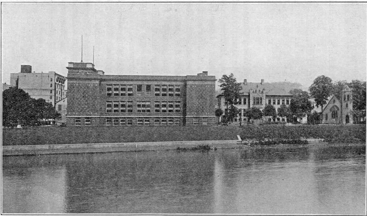
CLEARFIELD HIGH SCHOOL
With Junior High at right center and Episcopal Church at right.


251

CLEARFIELD COUNTY - PRESENT AND PAST


nurse. There is also an attendance officer, and a medical inspector for the schools.


     In the High School there is special instruction in manual training for the boys and domestic science for the girls, also instructors in music, drawing and physical training. The nurse looks after the health of the children, and milk is advised or furnished to under-weight or under-nourished pupils. An iodine preparation for the prevention and cure of goitre is given all pupils desiring it. The schools are well equipped for modern instruction and have high standing. There are in
all, six school, buildings.


     There were 1271 pupils in the Elementary Schools, which include the first six grades as follows: first 198, second 207, third 256, fourth 230, fifth 197, and sixth 183.


     There were 541 pupils in the Junior High School, which includes the seventh, eighth and ninth grades as follows: 7th 169, 8th 176, and 9th 196.


     There were 461 pupils in the Senior High School, which includes the tenth, eleventh and twelfth grades as follows: tenth 177, eleventh 164, and twelfth 120.


     There were 264 tuition pupils in the ninth, tenth, eleventh and twelfth grades, that come in from other districts, to High School and whose several districts pay a tuition for them. There are also some tuition pupils that come in and whose parents pay tuition for them. These are elementary pupils and for them, the districts are not required to pay. All these pupils are included in the general roster given above. There are many graduates of Clearfield High School who have and are now making their mark in the business, educational and financial world.


     Saint Francis Parochial School. The first Catholic School in Clearfield, Pa., was opened in 1893. Three Sisters from Erie, Pennsylvania, took charge of the educational work in the school. The number of pupils increased so rapidly that the


252

CLEARFIELD COUNTY - PRESENT AND PAST


school authorities were obliged to provide a more commodious building. In the fall of 1904, the new Saint Francis School was ready for occupancy. This building is situated on South Second Street, overlooking the West Branch of the Susquehanna river; it is a modern building with eight well lighted class rooms and a large auditorium.


     In 1909, Rev. M. A. Ryan, the superintendent, established and equipped the Commercial Department. He also increased the number of teachers to nine, and secured State accrediting for the High School. There are 379 pupils in attendance, of which 79 are High School Students. The primary and grammar grades occupy the first floor, the High School the second floor.


     Medical attention is given to the pupils, and special attention is given to physical culture, in both grades and High School. Courses in vocal and instrumental music are also offered. The cost to educate a pupil, per year, is $24.00. The following is a list of the number of pupils in each grade: primary 40, second 33, third 40, fourth 53, fifth 45, sixth 35, seventh 30, eighth 24, Freshman 25, Sophomore 28, Junior 16, Senior 10. Pupils attend this school from Clearfield, Grampian, Curwensville, Glen Richey and Woodland.


     The youngest Bank Examiner in the United States is Horace C. Whiteman, a graduate of Saint Francis School. Leo E. Shillenn, holding a very prominent position with the United States Steel Corporation, in New York City, is also a graduate of Saint Francis.


     The Early Schools. The first school near what is now Clearfield Borough, was taught in a log building, 1 I a miles Northeast of Clearfield, about the year 1806 or 1807. This was a "subscription" pay school as were all others until 1834, except those chartered by act of the Legislature in 1827.


     The old Academy which was chartered by this act, was


253


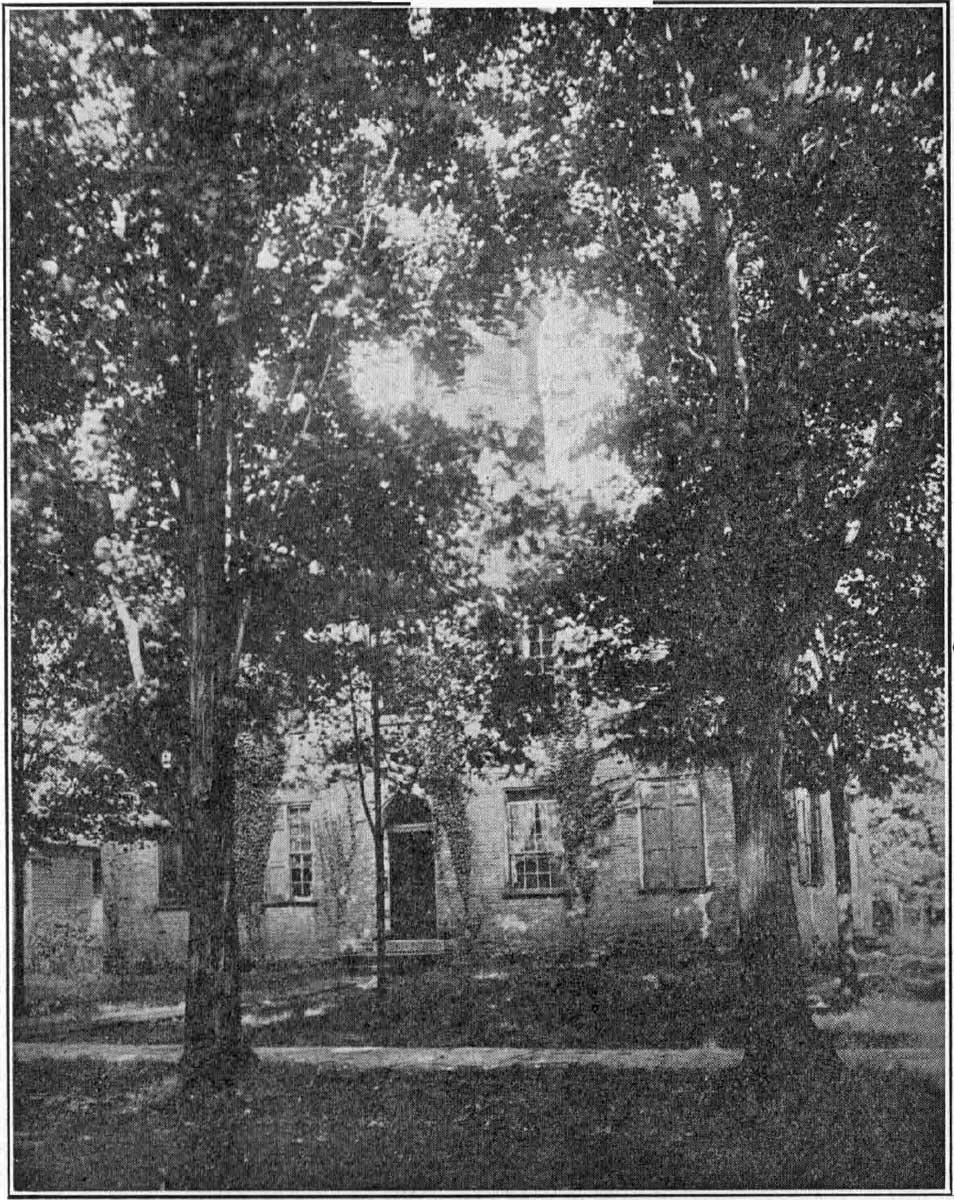
THE CLEARFIELD ACADEMY
It was Opened in 1830 and was the Highest School in the County until 1874


254

CLEARFIELD COUNTY - PRESENT AND PAST


opened in the fall of 1830, with A. T. Scriver, principal. This was while Clearfield was a part of Lawrence township. The academy was incorporated by the state and was required to receive not more than five poor children to be taught free, but for no longer than two years each. This was before the "general system of education by common schools" was established in Pennsylvania, (April 1, 1834), and therefore the academy was, with the exception noted, a pay school. From 1830 to 1874, the Academy continued to be the highest school in the county. Common schools were also held in the academy building.


     From 1852 to 1874, the common schools of the borough were held in the Town Hall, which stood on East Pine Street, and in the old Methodist Church building on Cherry Street. By arrangement of the directors of Clearfield borough and Lawrence township, the common school teachers were often paid alternately by each district, from the inauguration of the common school system in 1834, until 1874. The first County Superintendent was chosen in the Town Hall, in 1854,and the first County Institute was held here in 1855.


     A special act was passed by the legislature of Pennsylvania, to "establish graded schools in Clearfield", supplemented in 1872 by an amendment. James T. Leonard gave the lots and later a sum of money, to assist in the building of the Leonard Graded School, which was built and dedicated in 1874, after which time this building housed the common and High Schools of Clearfield for some years. It is still used for part of the elementary grades.


     What is now the Junior High School building, then the High School Building, was first occupied in 1903. A bequest of money to establish the Manual Training and Domestic Science Departments, was made by David McGaughey in his will, and Mrs. McGaughey afterwards helped substantially to equip the chemical laboratory for the High School.


255

CLEARFIELD COUNTY - PRESENT AND PAST


An addition to this building was first occupied in 1924, when the Freshman class was added to the Junior High School as the ninth grade. The present fine Senior High School building was first occupied in 1917. The County Institute is now held in its spacious auditorium.


THE CLEARFIELD HOSPITAL


     The Frederick Mossop Memorial Hospital. The Clearfield Hospital, though located just outside the borough of Clearfield, was first organized through the generosity of some of Clearfield's citizens, especially the Mossops. The following information is taken from statistical report for the year ending May 31, 1924. The number of admissions, 2,211. Of these 1,890 were pay patients and 280 were free patients while 41 were part pay patients. The number of out patients was 2,453. The average number of patients per day was 73. There were in all, 1,958 operations performed. There were 976 cases medically treated, and 1,942 surgically treated.


     The receipts from patients were nearly $121,000, from contributions nearly $230, from State Appropriation a little over $11,140, the total being about $132,370.


     The average number of pupil nurses is 44, Staff nurses 11, Special nurses 12, the average number of patients per nurse being one and one-third. An addition to the hospital was opened in 1923. The Hy. M. Kurtz Nurses' Home was contributed by the Hy. M. Kurtz Estate.


     The Hospital conducts a school of nursing with a corps of five nurses and six doctors as instructors. Thredbyears of training are required before nurses graduate, divided into Preparatory, or first year, Junior or second year and Senior or third year. The first three months the student is on probation; if she shows promise and is willing, she goes on with training.


     Churches and Sabbath Schools. Clearfield is well supplied


256

CLEARFIELD COUNTY - PRESENT AND PAST


with churches, most of which have their own buildings, others using halls or other rooms for services.


     People. The population is more than 9000. The citizens of the town are intelligent and enterprising. The sessions of Court and of the Institute bring in many people for those occasions.


     There are also many county and other conventions and meetings held here adding interest and value to life in the town.


     There is a very active Y. M. C. A. which does much for the young people, besides other organizations of which space does not permit the mention.


     So many individuals have contributed in both past and present to the upbuilding and betterment of Clearfield that it would be impossible within our limits to name them here. A number of those who have lived here at one time or another have also become prominent in other spheres of action; as an instance among others Cyrus E. Woods, who has been Secretary of the Commonwealth, Minister to Japan, etc.


COALPORT, IRVONA AND GLEN HOPE BOROUGHS


     These boroughs are all surrounded by Beccaria township, and were early settled by the pioneers of that district.


     The site of Coalport was an old farm along Clearfield Creek, on which was a sawmill and farm house owned by Francis Moran. This property was sold in 1876 to James Haines, and by him plotted and sold out in town lots. Lumber and coal operations here have made the town.


     Col. E. A. Irvin founded the town of Irvona, a mile or two from Coalport. Here he and others engaged in lumber and coal operations, and a large tannery was built.


     These towns are both connected with Bellwood, Cresson and Punxsutawney by the Pennsylvania, and the New York Central extends down Clearfield Creek from Irvona to Clearfield.


257

CLEARFIELD COUNTY - PRESENT AND PAST


     Glen Hope is an old settlement, having been located on the Janesville Pike many years ago, where it crosses Clearfield Creek. As other routes of travel have opened and the lumber business has gone, its growth, at one time quite rapid, has been checked. It is on the New York Central Railroad to Clearfield.


     Glen Hope was made a borough in 1878, Coalport in 1883 and Irvona in 1890.


     In the Coalport-Irvona High School there is a principal and three other instructors.


     In Coalport there are six grade teachers in the building. In Irvona there are six grade teachers in the building.


     In Glen Hope the school is divided into grammar and primary.


COOPER TOWNSHIP


     Cooper is bounded on the north by Covington and Karthaus Townships and Center County, on the east and south by Center County, on the west by Karthaus, Covington, Graham and Morris Townships. The river forms the northern boundary, Moshannon Creek the southern and eastern.


     The New York Central railroad crosses the southern part of the township. The old Indian path also crossed Cooper.


     People. The population is around 5000. Winburne, Kylertown, Viaduct, Peale and Grassflat are small towns.


     Coal mining is the principal industry in the southeast, but there are very good farms in the center of the township and especially around Kylertown.


     Churches and Schools. There are a number of churches in the different sections of the township.


     Cooper has a high school with five instructors, including the principal. All the other schools are more or less graded, except five which are one-room mixed schools. In all there are thirty-six teachers in the schools.


258

CLEARFIELD COUNTY - PRESENT AND PAST


     Settlement and Organization. The township, organized in 1884, was named in honor of Daniel Cooper, the pioneer settler who located near Kylertown in 1828.


     Kylertown was named in honor of the Kylers, who settled here at an early date and many of whom still live in the vicinity. Other settlers were the Hoovers, Fulmars, Hughes, Raymonds, Neabels, Stemdechners, Raders, Hartles, Bearns and Santcrofts.


COVINGTON TOWNSHIP


     Covington is bounded on the north by Elk and Cameron counties and Karthaus township, on the east by Karthaus township, on the south by Girard, Graham and Cooper townships, and on the west by Girard township.


     The river is on the southern line and Mosquito and Sandy Creeks flow across the township.


     The New York Central Railroad follows the river. The old Caledonia Pike crossed the township diagonally. There is some fairly good farming land, but much of the township is better adapted to timber culture, being hilly and rough. There is some coal.


     The township is about eleven miles long and three and one-half miles wide, giving it an approximate area of 40 square miles. The water power of the streams has been utilized in the past for running a number of sawmills.


     People. The population is around 500. The township was organized in 1817. Frenchville and Keewaydin are small towns or rather centers of communities round about.


     Early Settlements. It is hard to say who was the first settlers within what is now Covington township, as Karthaus township was taken from it and most of the earliest settlements were made in that portion. The real settlement of Covington was made by French immigrants, who came over at the invitation of John Keating, who mapped 22,000


259

CLEARFIELD COUNTY - PRESENT AND PAST


acres of land, publishing descriptions of the tract in France. The sale of these lands was begun in 1827.


     The first persons to locate were Nicholas Roussey and Irene Plubel in 1830. Next came Francis Coudriet and Claude F. Renaud. Coudriet was the postmaster at Frenchville, and held the office for 18 years. Among those who came later were the Mulsons, Hyacinths, Hugueneys, Brenoels, Gaulins, Bergeys, Barmoys, LaMottes, Leigeys, Garmonts, Biglemans, Rougeuxs, Verbecks, Tourails, Rollets Hugards,.LeContes and others. Many of the descendents of the early settlers now reside in other parts of the county.


     J. T. W. Schnarrs acted as agent for the sale of these lands. The settlers could not at first speak English and had with them an interpreter, Jacob Weiskopf. The first land surveys were made by Charles Treziyulney, a Polish engineer, who was also a Justice of the Peace in Center county. He had been a nobleman in his own country.


     About 1833 Irene Plubel died, and Rev. Father Leavey was here and said Mass at Plubel's house before he died. Later a log church was built. Now there is a substantial stone Catholic church. It was dedicated October 8, 1873. At Keewaydin there is an Evangelical Lutheran church


     Covington township has four one-room mixed schools with about one hundred pupils. A school house was built near Frenchville about 1838.


CURWENSVILLE


     Citizens. The Irvin and Patton families probably did most for the early and later material prosperity of Curwensvflle. In other ways, many left their mental impression on its life. Among them were Josiah Evans, Dr. Hoyt and 'Squire Thomas McClure. As a teacher, G. W. Weaver had a profound influence for good upon the pupils under his charge. Catherine Thompson, just lately deceased, who spent most of the hundred years of her life in the town, helped


260

CLEARFIELD COUNTY - PRESENT AND PAST


throughout her life of thrift and decision of character, and her example in training up her children in the way they should go, to mould the public sentiment that has made Curwensville the characteristically moral and religious town that it is. The names given are only representative of the many that might be mentioned but cannot, within the limits of this brief sketch.


     Of living citizens, we need not speak. Suffice it to say, they are upholding the honorable traditions of their forefathers and foremothers. The present population is over three thousand.


     Industries. Among the industries of the past, are the woolen mill, foundry, saw and grist mills, (the big saw mill was built in 1889,) match factory, tanneries of the old style, and lumbering. At present there are two steam tanneries, Crescent Fire Brick Works, blouse factory, job printery, lumber yard, milk depot, one newspaper, etc. There are two banks, and a large number of stores.


     The Pennsylvania Railroad came in 1874, the Buffalo, Rochester and Pittsburgh in 1893 and the New York Central in 1903-4. The Lakes-to-Sea Highway extends through Curwensville, east and west.


     Schools of the Present. There were 1020 pupils enrolled in Curwensville schools (1924), of whom 184 were High School pupils and 876 pupils in the grades. In charge of these pupils there were 24 instructors, including the Supervising Principal and Assistant Principal. There are six High School teachers, three Junior High School teachers and thirteen elementary grade teachers. The schools are much overcrowded at present, but provision to remedy this condition has been authorized and is now being made by adding to one of the three school buildings.


     Churches and Sabbath Schools. There are eight churches


261

CLEARFIELD COUNTY - PRESENT AND PAST


and Sabbath Schools. The first Sabbath School in the county was held in Curwensville in 1824, as noted elsewhere in this history.


     Early History. Paul Clover was the first settler who brought his family, his blacksmith shop being located where 'Squire John A. Dale's house now stands and his residence nearby. He afterward kept a hotel near where the Susquehanna house now stands. The junction of Anderson Creek with the River, is a very historical spot, as is shown in the general history of the county, given elsewhere. On the former bank of the Creek is the oldest graveyard in the county, shaded by a mighty maple. The Indians buried here before the coming of the white people.


     The big maple is seventeen feet, four inches around at six feet from the ground. It has two large branches, and must have been standing there when the white people first came. Some of its branches are dying. It should be preserved.


     The town was named by John Curwen, Sr., of Mongtomery county, who obtained letters patent for about three hundred and fifty acres of land, covering the site of Curwensville, from the State of Pennsylvania in 1798. On this land, Curwen had forty-eight lots laid out about the year 1805, between what are now known as Thompson and Locust Streets. John Curwen left his land to his son, George Curwen, from whom most of it was purchased later by John and William Irvin. Up to the year 1812, not a single building had been erected on the town plot.


     Paul Clover's house and shop seem to have proved to be on the Curwen lands, but were not on the plotted part. Job England had a log house where the John Patton residence now stands and a man named Weld, had a cabin opposite the present Swoope residence. In 1813, Daniel Dale built the first house in the town as then laid out, at the present corner


262

CLEARFIELD COUNTY - PRESENT AND PAST


of State and Filbert Streets. A post-office was established in 1821, and William McNaul was appointed the first postmaster, April 9th of that year.


     Coming of the Irvins. William Irvin came in the year 1818, having purchased, in 1811, more than three hundred acres of land across the river, opposite the mouth of Anderson Creek. Here he built a dam, said to have been the first on the West Branch, and erected a grist mill. The Erie Pike was completed in 1823 or 1824 through the town and brought an increased settlement. In 1845 six lots, two of them corner lots were bought for $60.00.


     The First School. The first school seems to have been taught by Jesse Cookson in 1812-13, in a dwelling house. Josiah Evans was the second teacher. The Curwensville Academy was started in 1833, and was exempt from taxation by the Act authorizing it, passed in 1832. Ground for the Academy was given by John Irvin. The Patton Graded School for the building of which John Patton gave nearly $20,000 was erected in 1885. The first school house built by the borough was in 1854.


     The borough of Curwensville was incorporated by Act of the Legislature, February 3, 1851. Before this, it was a part of Pike township. Curwensville has had its territory enlarged a number of times. By the census of 1880 it had a population of about 700.


DECATUR TOWNSHIP, CHESTER HILL AND OSCEOLA MILLS BOROUGHS.


     Decatur township is bounded on the north by Boggs and Morris townships, on the southeast by Center county, on the southwest by Woodward township. Moshannon Creek separates Decatur township and Osceola Mills from Center county.


     Coal Run and other branches of the Moshannon drain


263

CLEARFIELD COUNTY - PRESENT AND PAST


most of the township. There are deposits of coal and fire clay. There is good farm land in the township.


     The Pennsylvania Railroad and the New York Central pass through the township. The Lakes-to-Sea Highway passes through from Osceola Mills to Chester Hill and Philipsburg.


     People. Decatur township has about 3700 people, Osceola Mills about 2500 and Chester Hill about 800. The eastern and southern parts of Decatur are the most thickly settled on account of coal operations here. Before the coal came into market, the principal industry was lumbering, while the timber lasted.


     Early Settlements. Hardman Philips, who gave his name to Philipsburg, owned most of the land in what is now Decatur township in his time, and he offered the inducement of cheap land to all those who would settle here.


     Abram Goss, a Revolutionary soldier, settled at what is called Stumptown, presumably in 1797, supposing it to be in Center county. A little later came Henry and Nicholas Kephart. Henry's grandson, Abednego Crain, a veteran of the Civil War, lives (1925) in Oscecila Mills. Henry Kephart was later lost on the mountain, on his way home from visiting his daughter at Hickory Bottom in Center county, and was never found. Valentine Flegal came about 1800. A man by the name of Crane or Crain bought land from Philips adjoining Goss and Flegal and started a colony of negroes under the leadership of Samuel Green, but for some reason
many of them died. They lie buried in the old briar grown graveyard east of the Goss Cemetery. Others who came later were the Reeces, Reams and Crowells. Valentine Flegal was a local preather and held services at Goss' in 1815.


     Mr. Winters probably made the first settlement at Osceola Mills. Daniel Hoffman was also one of the pioneer settlers of Osceola Mills. Thomas Mays and his son John


264

CLEARFIELD COUNTY - PRESENT AND PAST


were the owners of what is now Osceola Mills in 1849 and lived in the only two houses.


     Chester Hill owes its existence to Jacob F. Steiner, a lumberman, who bought the land where it stands. It was the old Valentine Flegal property. He bought other lands and built a saw mill there.


     Schools. Decatur township has three graded schools with seven teachers and fourteen one-room mixed schools with fourteen teachers. A proposition to consolidate some of the schools has been twice voted down. The first school house in Decatur township is said to have been built on the farm of Adam Kephart. About 1848 there were but two schoolhouses.


     Schools of Osceola Mills. In the schools of Osceola Mills there are nearly 700 pupils, with an average attendance of over 600. In 1925 there were 138 in the four High School classes and 530 in the grades from one to eight. Fifty-three of the High School pupils and a few of the others were tuition pupils from outside of the borough. The average cost per pupil in 1923-24 was $38.00. There are twelve grade and five High School teachers including the Supervising Principal.


     In Chester Hill schools there are four rooms with one to three grades in a room and four teachers. There are nearly 150 pupils.


     Organization. Decatur township was organized in 1828, Osceola Mills in 1864 and Chester Hill in 1883.


DU BOIS CITY


     DuBois became a borough in 1881 and a third class city in 1910. It has a present (1925) estimated population of 14,000. There are five miles of street railway within the city. This also. connects DuBois with Sykesville, Reynoldsville, Big Run, Punxsutawney and Falls Creek.


265

CLEARFIELD COUNTY - PRESENT AND PAST


     There are also bus lines to Clearfield and intermediate towns, and to Sabula, Reynoldsville and Brookville.


     It has the main line of the Buffalo, Rochester and Pittsburgh Railway passing through it, with a branch to Clearfield, also the Allegheny Division of the Pennsylvania, and is the terminus of the Buffalo and Susquehanna Railway. 59 passenger trains arrive and depart every twenty-four hours.


     The city is supplied with natural gas, electricity and good water.


     The streets with a few exceptions are well paved and improved.


     There is a city and community playground and park covering 27 acres.


     The Civic Organizations are: The Chamber of Commerce, DuBois Business Men's Association, Modernized Credit Exchange, Community Rest Rooms, Rotary, Kiwanis, Community Red Cross Nurse.


     The Associations are: Acorn, Elks, Country Club, Knights of Columbus, Masons, Y. M. C. A., American Legion and other fraternities.


     There are a number of department stores and others, as hardware, shoes, men's goods, etc. There are also six wholesale institutions which cater to home and outside communities.


There are two hospitals, the DuBois Hospital and Maple Avenue Hospital.


     There are four banks: The Deposit National Bank, The DuBois National Bank, The Union Banking and Trust Company, The People's State Bank, having an aggregate of deposits of $7,500,000. The City has a morning and an evening daily newspaper, The Courier, and The Express.


     The industries are as follows: Adrian Furnace Co., J. R. Osborn Machine Co., Alpha Silk Mills, Vulcan Soot Cleaning


266

CLEARFIELD COUNTY - PRESENT AND PAST


Co., DuBois Overall Works, DuBois Clay Co., DuBois Iron Works, Jackson China Co., DuBois Locomotive Works, DuBois Car Shops, B. & S. Car Shops and Terminal, DuBois Granite Co., G. W. Pifer & Sons Lumber Co., Pyramid Stone Mfg. Co., Huston & Irwin Mfg. Co., Hydraulic Pressed Brick Co., DuBois Candy Co., DuBois Co-operative Dairyman's Association, DuBois Fertilizer Works, DuBois Flour Co's. Mill, L. M. Kriner Milling Co., Atlantic Refining Co., Freedom Oil Works, Penn Public Service Co., etc.


     There are exchanges of the Bell Telephone Company and the Somerville Telephone Co. and offices of the Western Union and the Postal Telegraph Companies.


     There are the Avenue Theater, the Elk Theater and the Carlton Theater.


     Early Settlement. Prior to 1812 Mr. John Casper Stoeber, of Dauphin County, Pa., grandfather on the mother's side of the present generation of Scheffers (some write it Shaffer now), who with their descendants still reside in DuBois and vicinity, pre-empted some land in this section of the State, which in the course of time was entailed to Mrs. George Scheffer (daughter of Mr. Stoeber and mother of George, Frederick and Michael Scheffer). George Scheffer and his wife and their three sons and an equal number of daughters left Dauphin County in the spring of 1812 to hunt up his inherited land, with a view to improving it. They arrived at Joab Ogden's (now Carlisle Station on the B. R. & P. Railroad about five miles south of DuBois), which by the way was the only family except the bachelor James Woodside, for twenty miles around. "The next day, May 13th, they went as far as where the `Rumbarger House' now [1887] stands, and put up a bark shanty beside the spring."


     The land on which they built their bark shanty belonged to a Mr. Gaskill from whom George Jr. bought it. This is the land that John Rumbarger finally bought in 1865. The


267

CLEARFIELD COUNTY - PRESENT AND PAST


Stoeber pre-emption claim lay a few miles up Sandy Lick Creek. It is now known as the "Aunt Katy Shaffer Place," where Shaffer station now is.


     In the summer of 1872 the town was laid out and called Rumbarger. About this time John DuBois appeared upon the scene.


     John DuBois commenced his little mill in the fall of 1872, and the large mill in 1873, completing the same and putting it in operation in May, 1876.


     The DuBois Iron Works were built in 1875-6. The electric light connected with the works was started in 1885 and first furnished light in January, 1886.


     For many years Bell, Lewis and Yates, carrying on large mining operations in Sandy township had their general offices and a large store in DuBois.


     The population is given, as in 1872, three families, in 1880 U. S. Census 2,719. In 1925 there are 14,000 people in DuBois City.


     Up to 1885 there was no telegraphic accomodations [sic] except at the offices in connection with the railroad stations, but in that year the Western Union established an office in the central part of town.


     In August 1885, the Central Pennsylvania Telephone Co. established their office in a drug store on the corner of Long and Courtney Street, thus giving telephone connection with Luthersburg, Curwensville and the County Seat.


     DuBois, having been at first of rapid growth at a time when timber was yet plentiful, the buildings were for many years practically all constructed of wood, so that it is not to be wondered at that there were many fires, notably in November 1880, December 1883, in February 1886 and worst of all in 1888, starting near the B. R. & P. Station and nearly finishing up the town. At that time there was no adequate fire protection.


268

CLEARFIELD COUNTY - PRESENT AND PAST


     Churches. DuBois has the following denominations holding religious services in the City: Baptist, Roman Catholic, Christian Science, Episcopal, Evangelical, Lutheran, Presbyterian, Methodist, Jewish Synagogue and Salvation Army. In all there are 22 churches and religious meeting places in DuBois.


     First Church Services and Churches. In 1868 Rev. T. J. Baker preached occasionally in the dwelling of John Rumberger. In 1870 Rev. L. G. Merrill held a revival meeting in the old white school house on the West Liberty road. These were held by the Methodists. The first church building in DuBois was by Rev. J. A. Dunlap of the Evangelical Association, who built a chapel on "Cottage Hill", second ward.


     Schools. The public Schools of DuBois are housed in six quite modern buildings and are fairly well equipped, though there is in school matters as elsewhere, always room for improvement. Wm. C. Sampson is city superintendent.


     There are in all 88 instructors, as follows: Superintendent of Schools, secretary to the superintendent, four grade principals, fifty-nine grade teachers, one High School Principal and twenty-three High School instructors, including a physical director, a supervisor of music, a supervisor of drawing and a school nurse.


     In the schools there are, in all, 2,758 pupils, of whom 2,170 are in the grades as follows: 1st grade 313, 2nd grade 279; 3rd grade 260; 4th grade 321; 5th grade 307; 6th grade 252; 7th grade 251; eighth grade 187.


     In the High School there are 588 pupils as follows: 9th grade 242; 10th grade 154; 11th grade 124; 12th grade 68. Of these twenty were tuition pupils. Special provision is made for instruction in music, art and physical education.


     Vocational training in the High School consists of home economics for girls and manual training for boys.


     Under the school nurse there are nutrition classes for


269

CLEARFIELD COUNTY - PRESENT AND PAST


under-nourished children, who are given milk. Iodine pills are given to all pupils once a week as a prevention and cure for goiter.


     St. Catherine's Parochial School. The building was erected in 1889, at which time there were four teachers instructing about 250 children. At present there are 12 teachers and a principal.


     There are 12 classes in all-8 grades and four years of High School as follows: pupils in first grade 72, second grade 63, third grade 69, fourth grade 63, fifth grade 57, sixth grade 51, seventh grade 43, eighth grade 36, ninth grade 35, tenth grade 37, eleventh grade 25, twelfth grade 24; total 575; of whom 121 are in High School and 454 in the grades. Percentage of attendance 99 per cent. Cost per pupil $14.86 for the past year.


     Some of the teachers have their degrees, and all the others are engaged in university work, leading to degrees.


     DuBois Business College. The DuBois Business College gives instruction in six different courses, and is a member of the National Association of Accredited Commercial Schools.


     It had an enrollment last year of 193 students, with a faculty consisting of five instructors. The newly instituted annual banquet has become a distinct feature, bringing back each year former students and thus keeping students and school in touch with each other.


     The DuBois Business College was organized in 1892 by J. N. Woolfington and so continued until 1896. After having been under a number of different managements since that time, it is now owned by Rosetta C. Turner, Manager, and Ralph E. Kendig, Principal.


     Early Schools of DuBois. Before DuBois was incorporated as a borough, it was a part of Brady township. The


270

CLEARFIELD COUNTY - PRESENT AND PAST


first school in the vicinity was in a one-room building and was called the White school. In 1876-7 a one-story, two-room building was erected. Later as the town grew, this building was replaced and others erected. In 1887 there were 1,192 pupils in all. Since that time the growth of the schools has well kept pace with the growth of the city.


FERGUSON TOWNSHIP


     Ferguson township is bounded on the north by Greenwood and Penn townships, on the east by Pike, Knox and Jordan townships, on the west by Penn, Greenwood and Chest townships, on south by Knox and Jordan.


     The river is on the north boundary, and branches of Little Clearfield Creek help to drain it.


     The Beech Creek Line of the New York Central Railroad crosses it. The surface is hilly, but fairly good for farming.


     There is some coal found.


     The population is about 600. Kerrmoor is the only town. It is small Marron is an old center. Gazzam, a former coal town is gone.


     Churches and Schools. There are a few country churches. There is one school graded into grammar and primary at Kerrmoor, and five one-room mixed schools with seven teachers and about 160 pupils in all. The first school house in the township was built on John Ferguson's farm sometime before 1841. Ross Robison was the first teacher.


     People, Organization and Settlement. Robert McKee seems to have been the first settler in the township some time before 1819. John Ferguson, Jr., son of John Ferguson, Sr., who had settled on the river above Arthur Bell's at an early date, Thomas McCracken, John Hockenberry, William Wiley and John Campbell all came to the township in 1823. The township was named in honor of John Ferguson.


271

CLEARFIELD COUNTY - PRESENT AND PAST


     Grier Bell, son of Arthur Bell, Sr., and the first white child born in the county, in Pike township in 1799, was one of the first settlers.


     The Bells, Straws, Moores, Tubbs, Youngs, and Watts are others who have been early settlers of the township. The present population is around 600. The township was organized in 1839.


GIRARD TOWNSHIP


     Girard township is bounded on the north by Elk county on the east by Covington township and on the south by Bradford and Graham townships.


     It is drained by the river on the south and by Surveyor Run, Deer Creek and Mosquito Creek. The Northern part is high and rough. Girard Knob is 2280 ft.


     It is crossed by the old Caledonia Pike. The New York Central Railroad is along the river. There are a few good farms, but the main industry is coal mining.


     Surveyor, LeContes Mills, Bald Hill and Odessa are small towns, whose populations vary with the running or stopping of the mines.


     The population is about 1000.


     The first settlement was made by the Livergoods, probably in 1817, near the mouth of Surveyor Run. This run was so named because a party of surveyors had camped here before any settlements were made. It was near this place on an old Indian path that Monks hid Giles' bloody shirt after the murder of Giles in 1817. Giles' dog afterward discovered and pulled it out of a hollow log. Other settlements were made by John Irwin in 1821, John Murray in the same year, John Spackman and Thomas Leonard, who came with their families in 1824.


     Abraham Jury was a potter and burned his ware in a kiln he made.


     Peter Lamm was a mill-wright and built a saw mill at


272

CLEARFIELD COUNTY — PRESENT AND PAST


the mouth of Deer Creek. Later millstones were added for grinding feed. Zacheus Mead came and cleared out a farm in 1826. The "Knobs" was settled at an early day by a number of families, as the Krises, Shopes and Smiths. The French settled in the eastern part near the Covington township line. Among them was Alphonso LeConte and later his brother Augustus. He built a saw mill and later a grist mill on Deer Creek, where he made flour. Many saw mills were built, all at first being run by water, later by steam. The township was organized in 1832.


     Churches and Schools. There were occasional religious services held as long ago as 1827, when Rev. William McDowell, of the Methodist Church preached at the home of the widow of John Murray. George Philip Gulich also sometimes preached. The French residents are principally Catholic and go to Frenchville to Church. There is now a Presbyterian Church in the township.


     Schools. There are two graded schools in the district, each divided into grammar and primary, and four one-room mixed schools, with eight teachers and about 130 pupils in all. The first school house in the township was of logs and the first school in it was taught by Cornelia Kincdde, at the place afterward called Congress Hill.


GOSHEN TOWNSHIP


     Goshen township is bounded on the north by Elk County and Girard township, on the east by Girard and Bradford townships, on the south by Lawrence and Bradford townships and on the west by Lawrence township. It is drained by Lick Run, Trout Run, Surveyor Run, Medix Run and the river.


     The New York Central Railroad passes through the township for a short distance.


     There are coal deposits in the southern part.


273

CLEARFIELD COUNTY - PRESENT AND PAST


     The farming section is in the south-central part also. Farther north it is rough and mountainous, making good huckleberry country.


     It has been a good timber country and is growing a second crop. The old Caledonia Pike crossed Goshen township.


     People. The population is nearly 600. Along the river are the small towns of Shawsville and Lick Run Mills.


     There are a number of camps belonging to different clubs. They are in the wilder northern part.


     Churches and Schools. There is an M. E. Church at Shawsville and a church and grange hall at West Goshen.


     There are four one-room mixed schools in the district, with four teachers and around 100 pupils. The first school house was built upon land of Isaac Graham about 1845 or 46.


     Settlement and Organization. The Bumgardner family took up land near the mouth of Trout Run, and a settlement was made there in 1820. Joseph Thorndyke came to Trout Run in 1822. He lived alone and was a trapper and hunter.


     Other settlers were the Irwins, Ross', Leonards and Flegals. Ellis Irwin was a prominent resident, and built the improvements at Lick Run Mills.


     Shawsville was started by Richard Shaw in 1849. He built a grist mill here in 1852, using the Matthew Ogden millstones. This was improved and a roller flour process put in later by A. B. Shaw. Later his son Edward made further improvements. The township was organized in 1845.


GRAHAM TOWNSHIP


     Graham township is bounded on the north by Girard and Covington townships, on the east by Morris and Cooper townships, on the south by Wallaceton borough, Boggs and Morris townships and on the west by Girard, Bradford and Boggs townships.


274

CLEARFIELD COUNTY - PRESENT AND PAST


     The river is on the north, Alder Run in the eastern and Moravian Run in the western part. The old Indian path crossed it near Grahamton. There is coal and possibly fire- clay, but the principal industry is farming. It has a number of good farms.


     People. The population is about 600. Grahamton and Sington are small towns or hamlets. The township was named in honor of James B. Graham, who came to the township about 1837. The Hublers and Crowells came in 1827 or 28. Others who came a little later include Thomas H. Forcey and Conrad Kyler. Graham township was organized in 1856.


     There are a number of country churches, both Methodist and United Brethren, in the township.


     There are five one-room mixed schools in the district, with a little over one hundred pupils.


GULICH TOWNSHIP AND RAMEY BOROUGH


     Gulich township is bounded on the north by Bigler and Woodward townships, on the east by Woodward township and by Center and Blair counties, on the south by Cambria county and on the west by Beccaria and Bigler townships. The Moshannon is on the eastern boundary and Muddy Run on the west. Gulich township surrounds Ramey borough.


     People, Churches and Schools. The population of Gulich township is something less than 3000, of Ramey borough less than 1000. The principal industries are mining and farming. There are a number of country churches, besides those in Ramey. Beulah Church was built about one- half mile from the present site of Ramey in 1859 by the Presbyterians. This was one of the first churches. In 1855 Henry Alleman organized a Union Sunday School from which originated the first church in Allemanville.


     Gulich township has four graded schools and four one-


275

CLEARFIELD COUNTY - PRESENT AND PAST


room mixed schools, with fourteen teachers and over 500 pupils.


     Ramey has a High School with two instructors, including the Principal, and six grade teachers in the building, with about 240 pupils. The first school house in the township of Gulich is said to have been built by Joseph Fry, Henry Alleman and Daniel Fulkerson in 1855 near Allemanville, on the land of Henry Alleman.


     Settlement and Organizations. Peter Gulich, or as it was then "Geulich", was probably the pioneer settler. John Glasgow came in 1840. Others were the Cresswells, Nevlings, the Hannahs, the Frys, the Allemans, the Hummells, the Fulkersons, the Rameys, the Flynns, the Conrads, the Ganoes, the Davis', Kingstons, McKeirmans, Stephensons and Ginters.


     Gulich township was organized in 1858 and Ramey borough in 1878.


     Smithmill (Janesville), Allemans, Ginter and Smoke Run are small towns or centers of population.


     The Janesville or Tyrone Pike was an important thoroughfare passing through Gulich township in by-gone days.


HUSTON TOWNSHIP


     Huston township is bounded on the north by Elk county on the east by Pine and Lawrence townships, on the south by Union and Pine townships, and on the west by Elk county and Sandy township.


     Bennett's Branch of the Sinnemahoning and Laurel Run, another branch of that stream, and the head of Anderson Creek drain the township.


     The Pennsylvania and the Buffalo and Susquehanna Railroads cross it.


     Parts of Huston have good farm land, but the south-


276

CLEARFIELD COUNTY - PRESENT AND PAST


ern part is mountainous and barren. There are deposits of coal near Bennett's Branch, and it was once well timbered over most of its surface.


     The Penfield Pike connects Penfield with Clearfield.


     People. The population is over 2000. Tyler, Penfield and Winterburn are small towns on Bennett's Branch and the Railroads. Tyler is a coal town, Penfield and Winterburn were started in lumbering days. The present industries are farming and mining.


     Churches and Schools. Before 1830 itinerant preachers came through Bennett's Branch valley, holding meetings at the houses of the few settlers. There are churches in different sections of the district, including Penfield, Tyler, Winterburn and Hickory. Huston has a school at Penfield that includes a High School and grades. There is also a graded school at Tyler. Besides these, there are five one- room mixed schools in the township. There are in all seventeen teachers and about 500 pupils.


     Educational matters seem to have moved rather slowly in early times. In 1856 teachers received from 12 to 16 dollars per month of twenty-four days and "boarded round."


     Settlement. The first settlers seem to have been John S. Brockway, Jesse Wilson and G. R. Hoyt. Brockway afterward moved to where Brockwayville now stands and gave it his name. Mr. Hiram was another early settler.


     "Uncle Billy" Long lived and hunted in this district for many years. P. P. Bliss, the singer, was born in the township when it belonged to Elk County. Lucian Bird came in 1869. He and his family have been valuable citizens.


     Huston township was organized in 1839.


JORDAN AND KNOX TOWNSHIPS


     Jordan township is bounded on the north by Ferguson and Knox townships, on the east by Knox, Bigler, and Bec-


277

CLEARFIELD COUNTY - PRESENT AND PAST


caria townships, on the south by Chest and Beccaria townships and on the west by Ferguson and Chest townships.


     Knox township is bounded on the north by Ferguson, Pike and Lawrence townships, on the east by Lawrence, Boggs, Woodward and Bigler townships, on the south by Jordan and Bigler townships and on the west by Ferguson and Jordan townships. Both townships are drained by branches of Clearfield and Little Clearfield Creeks. The New York Central Railroad enters both townships and the Pennsylvania goes through Jordan. The Janesville Pike crossed Jordan, and the old wagon route from Tyrone to Punxsutawney crossed Knox.


     People. The population of Jordan is around 1100. That of Knox nearly 2000.


     The principal industries are mining and farming. In Jordan are the towns of Ansonville, Berwinsdale and McCartney, and in Knox, New Millport, Carnwath and Boardman Ansonville was named for Anson Swan, a deaf mute.


     Schools. Jordan township has two two-room schools and five one-room mixed schools with nine teachers and nearly 300 pupils. The first school was built in 1820 near where Fruit Hill Church now stands.


     Knox township has one four-room school at Boardman, two two-room schools and five one-room mixed schools in other parts of the township, with thirteen teachers in all and about 400 pupils. The first schoolhouse in Knox township was built in what is now New Millport in 1842. The first teacher was Benjamin Roberts.


     Settlement. The first settler in Knox township seems to have been John Rea, who came here in 1806, and he was also the first settler of Jordan, moving there in 1819. When he first came, it was hard to keep domestic animals, especially


278

CLEARFIELD COUNTY - PRESENT AND PAST


sheep on account of the wolves and bears that prowled around the settlers shanty in great numbers.


     John Swan, James McNeal, and David Williams were other settlers of Jordan John Swan did quite a business making and shipping lye made from wood ashes, burning wood for ashes to produce it and also buying ashes from his neighbors. Robert Patterson came about 1823 or 24 and bought land in Jordan from Morgan, Rowles and Peters. The land in that vicinity is yet known as "Morgan's Land."


     Other settlers were the Blooms, Johnstons, Thompsons and others.


     In Knox township, James Hagerty came soon after James Rea, but was murdered mysteriously.


     Six or eight years before his drowning in the West Branch near Curwensville in 1824, Peter Erhart had located some land in what is now Knox Township. His sons later improved it and also in connection with it, another tract where New Millport now stands. The first dwelling house in New Mill- port was built by David Erhart, Sr., about 1834.


     The first industry here being mills, .suggested the name Millport and the word "New" was added to distinguish it from Millport in Perry county, when it was made a post office.


     Churches. Rev. Samuel Miles was a well known Baptist preacher, who traveled and preached in the county as early as 1835. In 1841 he organized the society that later built Zion Baptist Church, in Jordan, between 1843 and 1846. Later a brick church was built in Ansonville.


     In 1835 Revs. David McKinney and Samuel Wilson were sent as missionaries to Clearfield county, preaching in private houses, often in Jordan township In 1839 the organization at Fruit Hill was affected. In 1845, the church was built. A brick church was built in 1877. The Fruit Hill Picnic held


279

CLEARFIELD COUNTY - PRESENT AND PAST


here every year has come to be very largely attended by people from all over the county.


     In Knox township there are churches in different parts, including country and towns.


     Organization. Jordan township was organized in 1835 and Knox township in 1854.


KARTHAUS TOWNSHIP


     Karthaus township is bounded on the north by Cameron county, on the east by Clinton and Center counties, on the south by Center county, Covington and Cooper townships, and on the west by Covington township.


     It is drained by the river on the southeast, and by Basin Run, Mosquito Creek, Salt Lick Run and Upper Three Runs.


     The New York Central Line is along the river. The northern part is a rather wild country. There are some good farms in the central and southern part. There are beds of iron ore near the town of Karthaus.


     People. The population is around 900. Karthaus is a small town on the river, Pottersdale is on Three Runs. There are three or four church organizations. There is a graded school with three rooms in the town of Karthaus, and three one-room mixed schools in other parts of the district.


     Settlement and Organization. Peter Karthaus owned a large tract of land here and he and his agent, J. T. W. Schnars, came in 1815. In the year 1817, Karthaus and Geisenhamer built the old furnace at Moshannon Creek, as in the meantime bog ore had been discovered near the head of Buttermilk Falls, some four miles below Karthaus. The ore was conveyed up the river in canoes and flat boats and the iron extracted. Connected with the furnace, a foundry was built and hollow iron ware, stoves and other articles manufactured.


280

CLEARFIELD COUNTY - PRESENT AND PAST


Trouble however was experienced in getting the product of furnace and foundry to market, as the rafts and flat boats on which an effort was made to transport them down the river were often wrecked among the rocks of Buttermilk, so that pots and kettles and pans went to the bottom of the river, instead of to the housewives for whom they were intended. Eventually the enterprise was therefor abandoned. The present town of Karthaus is at the mouth of Mosquito Creek, quite a distance below the mouth of the Moshannon where Peter Karthaus' furnace was located.


     The later development of the timber and coal business for a time revived industrial conditions. The township was organized in 1841.


LAWRENCE AND PINE TOWNSHIPS


     Lawrence township is bounded on the north by Elk county, on the east by Goshen, Bradford, Boggs and Knox townships, South by Bradford and Boggs township, on the west by Pike, Pine and Huston townships. It formerly took in more area than at present, but is still one of the largest townships. It entirely surrounds Clearfield, and much of its early history is bound up with that of the county and has been given under that head.


     The West Branch crosses the township and it and Clearfield Creek form parts of the southeastern and western boundaries. The other principal streams are Moose Creek, Montgomery Creek and Little Clearfield Creek. Pine township was organized in 1873. It is attached to Lawrence and is west of it.


     The two bus lines that pass through the township on the Lakes-to-Sea Highway and the three railroads give good facilities for travel and transportation. The northern part of the township is rough and mostly covered by forest reservations and hunting camps.


     People and Industries. The population of Lawrence township is less than 5000. Parts of the township around


281

CLEARFIELD COUNTY - PRESENT AND PAST


Clearfield are most thickly peopled. The villages of Hyde, Glen Richey and Dimeling are in the southern part. The principal occupations are farming and mining, though many men and women work in mills, factories and offices in Clearfield. The nickel works at Hyde, the brick and tile works at Riverview and the tile works near the County Home are the principal industrial plants in the township.


     In early times there were many small saw and grist mills on the river, creeks and runs. Lumbering was the leading industry in its time. Considerable reforestation is being done on cut-over lands. There are two granges in the township, Lawrence and Mt. Joy.


     Schools. There are eighteen schools, with twenty-seven teachers and nearly 1000 pupils. There are seven graded schools and eleven one-room mixed schools. The school at Hyde was the first consolidated school established in the county. A new four-room brick building has lately been erected at Plymptonville, and one room has been added to Kerr.


     Early Schools. The first school house mentioned in historical accounts of the county and township is that it "was built one mile northeast of where Clearfield town is now situated." R. Will Thompson says that his mother, many years ago, pointed out to him the log remains of the old school house where she went to school. This was in sight of the present Paradise school buildings, on the present Charlton farm. School was "kept" in this old house at a very early date, probably in or soon after 1806.


     The next school house was probably near where the Collins greenhouse now is. In 1824 land was donated by Philip Antes to build a school where Wright's nursery was later. These old houses were built after the fashion of the day, such as have already been described, and schools were also held in rooms in dwellings, or in old discarded


282

CLEARFIELD COUNTY - PRESENT AND PAST


buildings. The Waterford school near the County Home is a very old school location, the first house having been erected in 1834 by private subscription. In the "Tom Hainey School" one teacher taught her pupils to read and spell backwards, running her spinning wheel while they recited. One of the first school houses on the "ridges" was built about 1823 or 24, not far from the present Pine Grove School. , In 1831 the first school house was built at Pine Grove.


     Early Settlement. The first settlement of the land now embraced in Lawrence township has been touched upon in the account of the settlements in the county. Martin Hoover Frederic Hennich or Haney, Abraham Passmore, Henry Irwin and Thomas Kirk, Samuel Fulton, George Philip Gulich, were other settlers, also John Kline who settled on the creek afterward called Montgomery in honor of the Philadelphians who owned the land hereabouts. Hugh Frazer, Peter Young, the Welches, John Carothers and Benjamin Jordan settled on or near the river.


     Alexander Read, called "Red Alex" came in 1802 and settled on the ridge where the Mitchell Stone House now stands. "Black Alex" Reed came in 1811. They were of different families and the two Alex's were distinguished by the color of their hair. Hugh Jordan and others also located on the ridges.


     Organization, Etc. Lawrence township was organized in 1813, it being taken from old Chinklaclamoose district, but it was not made a separate election district until 1821, voters casting their ballots in the County Court House.


     The first post office in the county was in Lawrence township, being on the present Mitchell Stone House Farm, in 1813, kept by Alexander Read until 1819 when it was abolished.


     The township was named in honor of Captain Lawrence.


283

CLEARFIELD COUNTY - PRESENT AND PAST


Center Church is one of the oldest Methodist organizations in the county.


     Mrs. Heisey, who was probably the oldest woman who ever lived in the county, died a few years ago at the age of 107.


LUMBER CITY BOROUGH


     This borough takes in so much territory that a former school superintendent once remarked that "it is the only city whose farmers raise enough produce on their farms to feed its whole population."


     The only industry within its limits at present is the Good Brick Plant, employing most of the population, at times.


     The older part of the town is pleasantly situated on the north side of the West Branch and the newer part called Good is on the same side of the river farther down, and near the brick works. Its population is around 300.


     The borough was organized in 1858, at which time and for many years later it was a thriving metropolis of the lumber industry,—hence the name "City".
Former Industries. Besides the lumber business which was very extensive in its time, much timber being rafted in here, Lumber City has had in its time a grist mill, and saw mills run by water from a dam on the river, foundry, shook shop, splint mill for preparing wood for matches, three hotels, post office and a number of stores. For many years it had two doctors of the older times, Ross and Fetzer.


     An iron bridge that spans the river has taken the place of the wooden bridge that was built by the Kirks about 1851, and stood for fifty years or more.


     Settlements. Benjamin Fenton moved onto what is now the John Kreps farm in the spring of 1803. John Ferguson settled on the river, on the farm now owned by the J. B. Ferguson heirs, in 1803. He was a Revolutionary soldier and


284

CLEARFIELD COUNTY - PRESENT AND PAST


lies buried in the Ferguson graveyard on the farm. Jason Kirk settled just above, about 1812. The Scofields bought the Benjamin Fenton place and later, about 1846 probably, the Kellys located on the same farm.


     The Hiles came to Lumber City and bought what is now the older part of the town about or before 1830.


     Education, Schools and Churches. The present school building is of brick and was built in 1910. There is a teacher for each of the two rooms, grammar and primary. There are about 75 pupils. The people of the town take an active interest in education.


     The first school that was within the present limits of the borough was probably located at the river near the Ferguson place.


     The second was on the hill above the Hipps farm. When this school was established, it was on the old state road. The land belonged to Jason Kirk, and he planted apple and peach trees around it so the children could later have the fruit.


     There are two church buildings, Methodist and Presbyterian, in Lumber City, but the Methodist only is used. There is a Sabbath School with over one hundred in attendance every Sunday.


MORRIS TOWNSHIP


     Morris township is bounded on the north by Graham township, on the east by Cooper township and Center county, on the south by Center county and Decatur township, and on the west by Graham, Boggs and Decatur townships.


     It is drained by Moshannon Creek which forms its southeastern boundary.


      Two lines of the New York Central pass through the township. An electric railroad connects its towns with Philipsburg.


285

CLEARFIELD COUNTY - PRESENT AND PAST


     People. The population is around 5000. Morrisdale, Allport, Munson and Hawk Run are mining towns. Mining is the chief occupation, though there is a little farming.


     Churches and Schools. There are a number of churches of different denominations, especially in the towns.


     Morris township has a High School with three instructors including the principal. All the other schools are graded except four, which are one-room mixed schools. There are thirty teachers in all, with over 1000 pupils. There were a number of school houses of the old style built in the township in the days when there were no public schools, and those who sent children had to pay for their tuition.


     Settlement and Organization. Among its first settlers was Capt. Jacob Wise, Samuel C. Thompson, James Allport, etc. Morris was organized in 1836, but has been much reduced in size since then, Graham and Cooper having been taken from it. The township was named in honor of a patriot of the Revolution, Robert Morris.


PENN TOWNSHIP AND GRAMPIAN BOROUGH


     Penn township is bounded on the north by Brady, Bloom and Pike townships, on the east by Bloom and Pike townships, on the south by Greenwood and Ferguson townships, extending to the river, and on the west by Ferguson, Greenwood and Bell townships.


     Little Anderson Creek, Bell Run, Poplar Run and Curry Run flow through it. The borough of Grampian is entirely inclosed within it and Lumber City is at the southeast corner.


     The Lakes-to-Sea Highway extends for four or five miles through the township. There are about 900 people mainly of English, Scotch and Irish ancestry. There are a few of other nationalities.


     The first settlers were Scotch-Irish, Scotch, and Quakers of English ancestry. William Hepburn was the first settler,


286

CLEARFIELD COUNTY - PRESENT AND PAST


about 1803. Dr. Samuel Coleman, the Boones, Johnsons and Spencers came in 1808 and 1809, the Moores in 1810 and 1811 and some of the Walls in 1812. Among others who came a little later were the Bennetts, Englands, and the Severns and Cochrans (colored people). Samuel Cochran, a mulatto, came to the county in 1804 from Lycoming county, first settling on the south side of the river and later took up 300 acres of land in the Grampian Hills. He became a thrifty and successful farmer. His house was a stopping place for teamsters on the old Kittanning or State road.


     The Story of Joseph Boone and Dr. Samuel Coleman. Joseph Boone was formerly Sheriff of Washington, and while in office, had in his custody one John Nicholson, who escaped, leaving Boone liable on his official bond, and his property was thus swept away. Afterward Boone found Nicholson in Philadelphia, and in order to repair the losses suffered by Boone, Nicholson transferred to him and his sureties a number of land warrants which were afterwards surveyed to Hopkins, Griffith and Boone. Boone seems to have transferred title to 300 acres of this land to his friend Dr. Samuel Coleman, who came onto it a little previous to Boone's arrival.


     Dr. Coleman was a Scotchman, who had three men along with him to assist in clearing out his farm.


     One of these men was a colored slave named Otto. They camped at first in an open shed, thatched around with brush and slept on beds of chestnut bark "with the soft side up."


     The Grampian Hills. Dr. Coleman said the country reminded him of his native hills in Scotland, so he called it the Grampian Hills, by which name it has ever since been known. He settled on the farm now owned and occupied by D. D. Miller near Grampian,'and lies buried on the hill. Coleman was the first doctor in the county.


287

CLEARFIELD COUNTY - PRESENT AND PAST


     Boone, with his family, came up the river from Williamsport in a boat, and arrived at Squire Thomas McClure's in the early summer of 1809. They proceeded to Coleman's camp in wagons. The next day they built a log cabin and roofed it with bark.


     Boone was a man of education and a devout Catholic. He gave 100 acres of land for a Catholic Church building, graveyard and farm in Penn township. He was later chosen Prothonotary and Recorder of the county. He afterwards lived for some years at Clearfield.


     Others who came a little later than those mentioned were Caleb Davis, Gideon Widemire, Jonathan Waln and Joseph Iddings, with their families.


     Township Organization. Penn township was taken from Pike Township in 1834, on petition to the Court and was so named in honor of William Penn and in deference to the Friends or Quakers who helped very substantially to settle it.


     The first enumeration after it was made a township reports fifty-seven taxables. Joseph Cullingsworth was enrolled as having a post-office (one-half mile east of the present village of Hepburnia) Samuel Johnson, a sawmill, James and Elah Johnson, a sawmill, Jeremiah Moore a sawmill and a grist mill, and Spencer and Company a sawmill.


     The Irish Settlement. Not far from this time the twelve original Irish immigrants came from southern Ireland and with others who came a little later formed the "Irish Settlement" in the west central part of the township. Some of them walked from New York City.


     A Progressive District. The Grampian Hills has had a reputation for progressiveness in different ways for many years. A good share of the credit for this progress is assigned to the intelligence of the early Quakers who settled it, but


288

CLEARFIELD COUNTY - PRESENT AND PAST


much is also due to one man who, in spite of the difficulties of a pioneer life, acquired a valuable education, mainly through his own efforts. Elisha Fenton had the most complete library in the county in his day, and did all he could to interest others in a broader education. During the California gold excitement of 1849, he made the remark that there was more money for a young man to be made out of the soil of Clearfield county than he would find in California. In view of the mineral wealth that has been dug out of our hills since that time, this was prophetic. On his death Elisha Fenton left his books to found a library in this district. Before his death, about 1878, he prophesied that buggies without horses would later be seen running everywhere on the roads.


     Schools. A great deal of interest has always been taken in education.


     There are six schools with eight teachers, two of the schools being each divided into grammar and primary. The others are one-room mixed schools. There are nearly 300 pupils in the district. The first school house was on the farm now owned by Warner Wall, prior to 1818. It was built of logs.


     Schools of Grampian Borough. Grampian has a four- room building in which the schools are graded with four teachers and about 140 pupils. The first school house within the present limits of the borough was on the hill above the main part of the town.


     Organization. Grampian was first organized as Pennvine in 1885. Later, 1895, the name was changed to Grampian, to correspond with the name of the post office and railroad station. The Boones and the Moores were the first settlers within the limits of Grampian.


     The population is nearly 700.


     There are a number of stores and a grist mill, also


289

CLEARFIELD COUNTY - PRESENT AND PAST


the American Chickeries, a hatchery with two incubators whose total capacity is 100,000 eggs. 425,000 chicks were hatched in the spring of 1925, besides the custom hatching of 10,000 to 15,000. This is the second largest hatchery in Pennsylvania. There is also a poultry farm where a number of chickens are raised.


     The Grampian Hills Juvenile Fair was organized for the children some years ago. Its aim has been to interest children in agricultural pursuits. The fair is held in Grampian.


     Churches. There are three churches. Methodist, Friends and Catholic. The Catholics have the largest congregation. The Methodists and Friends each conduct Sabbath schools. The Methodist organization is a division of the original Spencer Hill Society, the other church being at Lumber City. Both are on the same clerical circuit. The parsonage is now located at Grampian.


PIKE TOWNSHIP
 

     Pike is bounded on the north by Pine township, on the east by Lawrence and Knox townships, on the south by Knox and Ferguson townships and on the west by Bloom, Penn and Ferguson townships. It surrounds Curwensville. The river crosses it and the other principal streams are Anderson and Montgomery Creeks, with Little Anderson Creek on the south. The land is hilly, with some good farms. There is coal, fireclay and building stone, and the township was formerly covered with fine timber, a second crop of which is coming on in many places.


     People and Industries. The population is less than 2000. The villages of Bloomington and Olanta are in the southern part. Farming and mining are the principal industries, though the brick plant at Stronach is in the edge of


290

CLEARFIELD COUNTY - PRESENT AND PAST


the township. There is also a grist mill in the village of Bridgeport.


     Schools. There are eleven one-room, mixed schools in the district. They have a supervising principal. It will be remembered that the first school in the county was at McClure's, which is in Pike township.


     Early Settlement. Arthur and John Bell, William Bloom and Thomas McClure were probably the first settlers with their families. Those who came a little later include the Smiths, Rosses, Caldwells, Dunlaps, Hartshorns, Maxwells, McCrackens, Rowles, Irvins, Halls, Liggits, Creswells and Askeys.


     The township was organized in 1813. Much of its territory has since been taken to form other districts.


SANDY TOWNSHIP


      Sandy township is bounded on the north by Jefferson and Elk counties, on the east by Brady, Union and Huston townships, on the south by Brady and Union townships and on the west by Jefferson county. The township surrounds the city of DuBois, in fact DuBois has overflowed into Sandy township quite extensively.


     Sandy Lick Creek flows across the township. The surface is not very rough. Falls Creek, Sabula and Shaffer's are the towns in the township. The Buffalo, Rochester and Pittsburgh, The Pennsylvania and The Buffalo and Susquehanna Railroads cross it. The electric railroad also goes through the township, and the Lakes-to-Sea Highway is just at its edge.


     The principal resources have been lumber and coal, and employment has been given many of its people in these industries. The population is around 7000, the major part of the people being found near and around Falls Creek and DuBois.


291

CLEARFIELD COUNTY - PRESENT AND PAST


     First Settlement. The Scheffers first settled on what is known as the "Aunt Katy Shaffer Place" at Shaffer's Station in 1812. There was no store nearer than "Old Town" as Clearfield was then known. The merchants at that time wagoned their goods from Philadelphia. The nearest mill was on the Clarion River forty miles away. They lived here for ten long, lonesome years before they had any neighbors, some Germans who commenced to settle about Troutville. The township was organized in 1878.


     Schools. The schools of Sandy township housed in 29 buildings have 45 teachers and a district superintendent, this being a third class school district. W. M. Spiglemyer is Superintendent. There are 1957 pupils in school, and about 50 out on permits and employment certificates. Of the whole number in school 203 are in High School and 1754 in the first eight grades. The High School Building has in all 15 rooms including rooms for all purposes. Many of the rooms in different parts of the district are crowded and one portable building is being used to house pupils.


     In the district there are a number of places where two one-room buildings stand on the grounds of a school, the one a grammar room and the other primary. Besides these there are six one-room mixed schools. Departmental teaching is carried on in the High School only, but this feature is expected to be extended to the 7th and 8th grades that will be housed in the High School Building this year.


     Special medical inspection and treatment is provided for pupils. The State Course of Study is used.


UNION AND BLOOM TOWNSHIPS


     Union township is bounded on the north by Sandy and Huston townships, on the east by Pine township, on the south by Bloom and Pike townships and on the west by Sandy and Brady townships. The streams are Anderson


292

CLEARFIELD COUNTY - PRESENT AND PAST


Creek and branches of Sandy. The DuBois water dam on Anderson is in Union.


     Bloom township is bounded on the north by Union township, on the east by Pike township, on the south by Penn township, and on the west by Brady township Anderson Creek and its branches drain it.


     The former Snowshoe and Packersville Pike crosses Union township, and the former Erie Pike crosses Bloom township.


     The Buffalo, Rochester and Pittsburgh Railroad now crosses both and the Lakes-to-Sea Highway crosses Bloom. Parts of Union are wild land and parts of Bloom are rough, but there are some good farming lands.


     People. The population of Union township is about 600 and of Bloom township about 400.


     Rockton and Home Camp are villages in Union. In Bloom, Greenville, Chestnut Grove and Bloom's Run are neighborhoods.


     There are churches at Rockton in Union township and Greenville and Chestnut Grove in Bloom township.


     Schools. Union has five one-room mixed schools. The first school house was of logs with board roof built at or near Rockton before 1839.


     Bloom has four one-room mixed schools.


     Settlement. The Laborde, Brubaker, Burns, Dressler, Whitehead, Welty and Kirk families helped to settle Union township, also Caleb Bailey, who had lived in other parts of the county before coming to Union.


     Before 1835 Jason Kirk and Jeremiah Moore of Penn township built a saw mill and later a grist mill. These mills were on Anderson Creek, presumably at the lower end of Rockton. Later William F. Johnson had a woolen mill here.


293

CLEARFIELD COUNTY - PRESENT AND PAST


Later still Joseph Seiler and sons owned and run the saw and grist mills and store.


     Isaac Rodden was one of the pioneer settlers of Bloom. James Bloom, son of William. Bloom, Sr., Jonathan Taylor, James McWilliams, John Ellinger and the Henrys were other pioneers.


     On the present Reams Farm, on the Lakes-to-Sea Highway is the location of the place known for many years as Packersville from Isaac Packer, who built a hotel here and made it a famous resort on the Erie Pike in the old days. The Snowshoe and Packersville Turnpike did not really pass here at all, but through Union township. The Erie Pike for a portion of its length hereabouts was later incorporated as the Cream Hill Pike.


     Organization. Union township was organized in 1848 and Bloom township in 1860.


WESTOVER BOROUGH, CHEST TOWNSHIP AND NEWBURG BOROUGH


     Chest township is bounded on the north by Bell, Ferguguson and Jordan townships, on the south by Beccaria township and Cambria county, on the west by Burnside township, and on the east by Ferguson, Jordan and Beccaria townships. Chest Creek flows north through its whole length and through Westover and Newburg Boroughs, and with its branches drains the township. There is a good deal of rough land and some good farming country. There are large deposits of coal.


     The Pennsylvania Railroad extends through the township and boroughs. The passenger service north and south is supplied over that part of the P. R. R. by the New York Central.


     People. The population of Chest township is about 800,


294

CLEARFIELD COUNTY - PRESENT AND PAST


of Newberg (or LaJose) around 200 and of Westover six or seven hundred.


     Five Points, Waukesha and McPherron are hamlets and there is also the McGarvey Settlement in the center of the township


     Among the first settlers were the Snyders, many of whose descendents are still living here. Other settlers were the Rorabaughs, Ramseys, Lees, Rosses, Lingafelters, Smiths. McGees, Thurstons, Hurds, Toziers, Michaels and others,


     Chest township was organized in 1826, but has been much reduced in size since that time. Newburg borough was organized in 1885. It is now generally known as LaJose, as that is the name of the post office and railroad station, from G. W. Jose who in the past had large lumber and farm operations here.


     Westover was organized in 1895. It was named after the family of that name. James McEwen laid out the town. The first house on the site of the town was built by T. S. Williams about 1840.


     Chest township has six one-room mixed schools with about 150 pupils.


     Newburg borough has one school divided into grammar and primary with about 60 pupils in all.


WOODWARD TOWNSHIP, HOUTZDALE AND BRISBIN BOROUGHS


     Woodward township is bounded on the north by Boggs and Decatur townships, on the east by Decatur township and Center county, on the south and west by Knox, Bigler and Gulich townships. Clearfield Creek is the line between Woodward and Knox on the northwest and Moshannon Creek between Woodward township and Center county.


     It is drained by affluents of these streams.


     The P. R. R. crosses the township. The township sur-


295

CLEARFIELD COUNTY - PRESENT AND PAST


rounds the boroughs of Brisbin and Houtzdale. A paved road connects with Osceola and the Lakes-to-Sea Highway.


     People. The population of Woodward township is about 3000. Of Houtzdale 1500 and of Brisbin 500. Woodward is most thickly settled in the southeastern part, on account of the mines of coal. The principal industries are mining and farming.


     Churches and Schools. There are churches of most denominations in Houtzdale and Brisbin and a few in the country districts.


     There is a High School in Woodward with two instructors including the High School principal. There are 59 pupils in the High School.


     The other schools are all more or less graded except five which are one-room mixed schools. For the grades there are seventeen teachers. In the grades there are about 700 pupils. There are 12 tuition pupils in the grades and seven in the High School. There are 10 school buildings. A course of study is outlined.


     Houtzdale has a high school with three instructors, including the principal. There are (1925) 73 high school pupils. The elementary pupils are divided into eight grades with a teacher for each grade. There are 308 pupils in these grades. The average attendance is about 97 per cent. Average total attendance in 1923-24 was 375 pupils. There are six tuition pupils in High School. State suggestions are used for outline. The cost per pupil in 1923-24 was nearly $40.


      The first school house was probably a frame structure erected at the corner of George and Mary Streets in 1874.


     Brisbin School is divided into High, eighth grade, intermediate, and primary. There are four teachers and over one hundred pupils.


     Settlement and Organizations. The land in Woodward


296

CLEARFIELD COUNTY - PRESENT AND PAST


township all belonged at one time to Hardman Philips who sold it to settlers on time at reasonable prices, often paid in "trade", that is a sack of meal or a bushel of potatoes or oats or wheat. The Hendersons were among the early settlers.


     Woodward was organized as a township in 1846.


     John Haley, now of Grampian, helped cut the timber where Houtzdale stands, in 1869. In the same year the town was first plotted under the direction of George M. Brisbin. Thirteen years afterward the town was re-surveyed. The first house was a log one. For several years after it became a mining town, it was a "rough town" in more ways than one. Houtzdale was organized as a borough in 1872. It was named in honor of Dr. Houtz, who owned the land on which the town was built.


     Brisbin was named in honor of George M. Brisbin, who built a log camp here in 1854. Isaac Goss lived near. Brisbin was organized as a borough in 1883.


     Mining of coal is the principal industry that keeps up these towns. In years past there have been many strikes, Much of the disorder resulting from these strikes might have been avoided if prohibition had come forty or fifty years earlier.


     There is a tradition that about a half mile south of Houtzdale a terriffic battle was fought with the Indians by General Wayne. It is said that relics such as arrow heads, bones, etc., have been found here. This does not seem like a very creditable story as it is not likely that General Wayne was ever in this vicinity.


County File Manager - Gary L. Caldwell


Return to Clearfield County Index

USGenWeb Archives

PAGenWeb

USGenWeb

USGenWeb Archives

PAGenWeb Project

USGenWeb Project


Copyright 1997-2024, USGenWeb Archives


Last update: Saturday, 12-Aug-2023 05:55:00 EDT