Fort
Henry.
Map
of Site of Fort Henry, Berks County.
Fort
Northkill.
Map
of Present Site of Fort Northkill.
Fort
At Dietrich Snyder's, Lebanon (and William), and Franklin.
Map
of Present Site of Fort Lebanon.
Map
of Present Site of Fort Franklin.
Forts
Everett, at Lehigh Gap and South of Lehigh Gap.
Map
of Present Site of Fort Everett.
Map
of Site of Fort Lehigh.
Map
of Site of Kern's Block House (Trucker's Fort).
Indian
Outbreak of 1763, Forts Deshler and Ralston (Brown's of Northampton
Co.)
Illustration
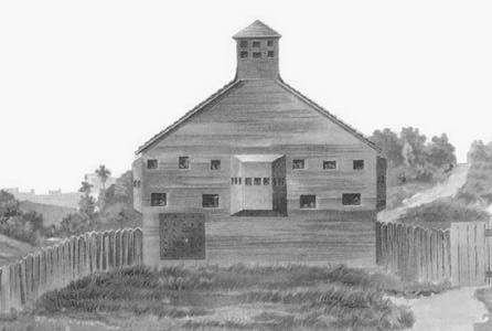
of Front View of Deshler's Fort, 1895.
Map
of Site of Deshler's Fort or Block House.
Illustration
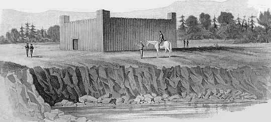
of Deshler Fort or Block House, Built 1760.
Illustration
of Ralston and Brown's Stockade. "Irish Settlement.
" (1) Illustration
of Ralston and Brown Stockade, in the "Irish Settlement.
" (2) Map
of Site of Ralston's Fort or Block House.
Fort
Allen.
Illustration
of Plan of Fort Allen. 1756.
Map
of Present Site of Fort Allen.
Forts
Norris, Near Wind Gap and Peter Doll's Blockhouse.
Map
of Present Site of Fort Norris.
Map
of Fort or Block House Near Wind Gap.
Map
of Site of Doll's Block House.
Nazareth
Stockade, Stockaded Mill at Friedenstahl, Gnadenthal & Christian's
Spring.
Illustration
of Old Whitefield House at Nazareth.
Historical Map
of the Barony of Nazareth.
Map
of Friedensthal, a Settlement of the Moravian Economy.
Illustration
of Christians' Spring. Stockade.
"Rose
Inn" and Fort Hamilton.
Illustration
of The Rose Tavern. Stockade.
Map
of Stroudsburg Showing Site of Fort Hamilton.
Illustration
of View of Stroudsburg In 1842, Showing Site of Fort Hamilton.
Forts
Hyndshaw, Dupui and Penn.
Map
of Site of Fort Hyndshaw.
Map
of Fort or Block House at Depui's.
Illustration
of Old Shawanee Church, Site of Fort Dupui
Map
of Site of Fort Penn at Stroudsburg.
II.
THE FRONTIER FORTS NORTH AND WEST BRANCHES OF THE SUSQUEHANNA RIVER.
By John M. Buckalew.
Introduction
to Part II and Forts Augusta at Sunbury and Jenkins.
Map
of Plan of Fort Augusta.
Illustration
of Headquarters of Commandant, Fort Augusta, 1757.
Illustration
of a Fort Augusta Cannon.
Illustration
of Remains of the Old Magazine of Fort Augusta.
Illustration
of Site of Fort Jenkins, Southwest View, Showing North Branch.
Illustration
of Site of Fort Jenkins, Southwest View, Showing Old Well.
Forts
Wheeler, McClure, Bosley, Rice, Freeland, Boone's Mills, Swartz and
Brady.
Illustration
of Site of Fort McClure, Town of Bloomsburg.
Illustration
of Fort Rice, at Montgomery's, Northumberland County.
Map
of Scene of the Sugarloaf Massacre, 1780.
Illustration
of Site of Fort Freeland, Showing Spring and Old Kitchen.
Forts
Muncy, Menninger, Antes, Horn and Reid at Lock Haven.
III.
THE FRONTIER FORTS WITHIN THE WYOMING VALLEY REGION.
By Sheldon Reynolds,
M. A.,
President of the
Wyoming Historical and Geographical Society.
Introduction
to Part III, Memoriam, Forts Durkee, Forty, Wintermoot's & Jenkins.
Map
of Position of the Wyoming Forts.
Illustration
of Forty Fort, Wyoming, in 1778.
Forts
Pittston, Stewart's Blockhouse, Wallenpaupack, Sullivan & Wyoming.
Illustration
of Pittston Fort on Susquehanna at Pittston.
Illustration
of Stewart's Block House.
IV. THE
FRONTIER FORTS IN THE CUMBERLAND AND JUNIATA VALLEYS.
By Jay Gulfillan Weiser.
Introduction,
Forts of Bedford and Blair Counties.
BEDFORD
COUNTY FORTS: BEDFORD
- RAYSTOWN, MARTIN,
PIPER, WINGAWN.
BLAIR
COUNTY FORTS: FETTER, HOLLIDAY, LOWREY, ROBERDEAU, ROLLER.
Forts
of Centre and Cumberland Counties.
CENTRE
COUNTY. POTTER'S.
Map
of Site of Fort Potter.
CUMBERLAND
COUNTY: Lowther, Morris, Franklin, Letort, Croghan, Dickey, Ferguson,
McAlister, McComb's.
Map
of Site of Fort Lowther.
Plan
of Fort Lowther, Carlisle.
Map
of Shippensburg, Pa.
Forts
of Dauphin and Franklin Counties.
DAUPHIN
COUNTY: Halifax
Map
of Site of Fort Halifax.
Illustration
of Plan of Fort Halifax.
FRANKLIN
COUNTY: Chambers, Davis, Loudoun, McCord, McDowell, Steel, McConnell's,
Lyttleton.
Map
of Site of Forts in Lower Cumberland Valley.
Map
from Mr Darlington's "Fort Pitt."
Forts
of Huntingdon County: Anderson,
Hartsog, Lytle, McCormick's, Crum's, McAlcvy's, Shirley, Standing
Stone, Bingham.
Map
from Mr Darlington's "Fort Pitt."
Forts
of Juniata, Mifflin, Perry and Snyder Counties.
JUNIATA
COUNTY: Patteron 1 and 2.
MIFFLIN
COUNTY: Granville
Map
of Site of Fort Granville, Mifflin Co., Near Lewistown.
Map
from Mr Darlington's "Fort Pitt."
PERRY
COUNTY: Robinson
SNYDER
COUNTY: Hendricks, A Blockhouse; McKee's.
Illustration
of Remains of Hendricks' Block House, Snyder County.
Introduction
and Notes, Jumonville's Camp and Fort Necessity and Notes.
Fort
Duquesne.
Illustration
of Fort Duquesne.
Map
showing Braddock's Route, 1755.
Illustration
1 of Troup Formations, Braddock's Battle.
Illustration
2 of Troup Formations, Braddock's Battle.
Illustration
3 of Braddock's Battle.
Fort
Pitt.
Illustration
of Redoubt at Pittsburg.
Map
of Fort Pitt.
Illustration
of Old Redoubt at Fort Pitt.
Map
of Fort Pitt in 1795.
Fort
Fayette and Notes. (Including Notes to FortDuquesne and Fort
Pitt.)
Fort
Ligonier. Part
I and
Part II. (Including Notes to Fort Ligonier. Remarks.)
Facsimile
of Washington's Account of Engagement Near Ft. Ligonier.
Plan
of Fort Ligonier with Part of the Retranchment.
Copy from Official Map
of the Borough of Erie Made in 1837.
Hannastown
and Notes, Miller's Station, Fort Hand and Notes.
Map
of Hannastown with Line of the Forbes Road and Route of the Indians
at the Time of its Destruction July 13th, 1782.
Carnahan's
Blockhouse, Forts Crawford and Notes, Wallace and Barr's.
Forts:
Palmer's, Shields', Walthour's, Pomeroy (Pomroy's), Wilson and Rugh's
Blockhouses, Allen
(Hempfield Twp.), Kepple's, & Stokely's & McDowell's &
Marchand's Blockhouses, Shippen at Capt. John Proctor's, Lockry's
Blockhouse, Philip Klingensmith's House, Gaspard Markle's House and
Station.
Map
of Fairfield Twp & Part of Ligonier Valley, Westmoreland,
Co.
Plan
of Fort Palmer.
Forts:
Burd - Redstone Old Fort & Notes, Settlers' Forts of Fayette Co.
& Notes: Minter's, Gaddis', Pearse's, Craft's, Cassell's, Ashcraft's,
Mason's, Conwell's, Spark's, Beeson's, Graybill's & Valentine
Crawford's Blockhouse.
Illustration
of Fort Burd or Redstone, Brownsville, PA.
Catawba
Trail. Forts of Washington County: Rice's, Lindley's, Wolf's,
Miller's (Blockhouse), Beelor's, Dillow's, Vance's, Hoagland's, Allen's,
Dinsmore's,
Roney's, Reynold's (Blockhouse), Wells', Doddridge's, Teeters', Beeman's
(Blockhouse), Marshall's (Blockhouse), Burgett's, Campbell's (Blockhouse),
Froman's, Williamson's Station, Bayon's (Blockhouse), Taylor's, Norris',
Cherry's, Lamb's Becket's, Milliken & McFarland, Woodruff's (Blockhouse),
Cox's, McDonald's Station.
Forts
of Greene and Indiana Counties.
GREENE
COUNTY: Jackson's, Garard's, Swan & Van Meter, Ryerson's, Statler's,
Martin's, Harrison's.
INDIANA COUNTY: Moorhead's & Inyard's (Blockhouse), Robinson's
Strong-House, Station at Black-Legs Creek, Armstrong - (Kittanning),
Notes, Description of Indian Town at Kittanning.
BEAVER
COUNTY (1): Fort McIntosh and Notes
Illustration
of Fort McIntosh - Site of Town of Beaver.
Illustration
of Site of Fort McIntosh Beaver.
Beaver
County Forts (2): Battle of Bushy Run & Notes
Sketch
of Col. Bouquet's Engagement with 400 Indians, 1763.
Beaver
County Forts (3): Presqu' Isle & Notes
Illustration
of Plan of City of Erie.
Plan
of Presque Isle and Harbor of Erie, 1793.
Erie
County: Fort Le Boeuf and Notes.
Sketch
of the Site of Fort Le Boeuf, Waterford, Erie Co., PA.
Illustration
of Fort Le Boeuf, 1796.
Venango
County: Forts Machault & Notes, Venango & Notes, Franklin,
the Old Garrison & Notes.
Illustration
of French Fort Machault.
Illustration
of English Fort Venango, 1760-1763.
Blockhouses
and Stations and Places of Defense Erected or Used After 1783
on the Western Frontier of Pennsylvania: Reed's Station - (Westmoreland
Co.), Blockhouse at Freeport or Buffalo Creek - (Armstrong Co.), Fort
Green - (Armstrong Co.), Clark's Blockhouse - (Armstrong Co.), Claypoole's
Blockhouse - (Armstrong Co.), Blockhouse at Bull Creek - (Allegheny
Co.)
INDIANA
COUNTY: McConaughy's, Allison's, Peelor's, Elder's, Thompson's,
McCartney's Blockhouses.
CRAWFORD COUNTY: Mead's Blockhouse - (Meadville)

Return
to State Wide Archives
Table of Contents
Technical
Problems?? Email Joe.
You
are our  visitor


 visitor