REPORT OF THE COMMISSION TO LOCATE THE SITE OF THE FRONTIER FORTS OF PENNSYLVANIA.
VOLUME TWO.
CLARENCE M. BUSCH.
STATE PRINTER OF PENNSYLVANIA.
1896.
THE FRONTIER FORTS OF WESTERN PENNSYLVANIA.
Pages 382-399.
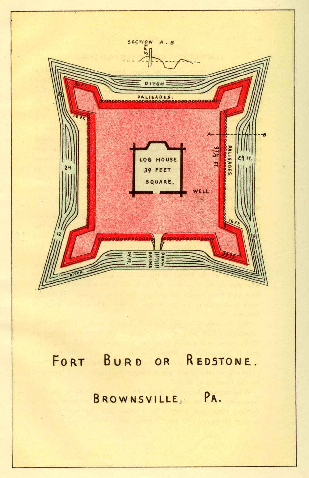
FORT BURD—REDSTONE OLD FORT.
Illustration of Fort Burd or Redstone.
The first occupancy of the place known as Redstone Old Fort was by Capt. Trent for the Ohio Company, who erected here, in February, 1754, a strong storehouse for their supplies and munitions. In the Journal of M. Coulon de Villiers, who commanded the French at the affair at Fort Necessity, it is thus described:
"June the 3oth.—Came to the Hangard, which was a sort of fort built with logs, one upon another, well notched in, about thirty feet in length and twenty in breadth; and as it was late and would not do any thing without consulting the Indians, I encamped about two musket-shots from that place. At night I called the sachems together, and we consulted upon what was best to be done for the safety of our periaguas [large canoes], and of the provisions left in reserve, as also what guard should be left to keep it.
"July the 1st.—Put our periaguas in a safe place. Our effects and everything we could do without we took into the Hangard, where we left one good sergeant with twenty men and some sick Indians. Ammunition was afterward distributed, and we began our march."
This force was sent out by the French, who had lately taken possession at the Forks of the Ohio, to intercept Washington, who was on his way from Wills creek with a force of Virginians and Provincials to occupy the same region. Washington's instructions, in the words of Gov. Dinwiddie, were as follows: (2.)
"By the advice of my Council, I gave orders to the Commander-in-Chief [Col. Fry] to collect his Forces together at Wills creek and march over the Allegheny Mountains; if he find it impossible to dispossess the French of the Fort, he is to build a Fort at Redstone creek, the crossing Place [Gist's?), or any other place proper that may be determined by the Council of War."
Washington, however, was obliged to capitulate at Fort Necessity and so returned with his forces without getting further than that point. No further attempt was made to occupy Redstone Old Fort during the French occupancy.
In the latter part of 1759, Col. James Burd was sent out with two hundred men, by order of Col. Bouquet, then commanding the King's troops at Carlisle, to open and complete the road which had been opened by Braddock, to the Monongahela river, at or near the mouth of Redstone, and there erect a fort. The English, under Gen. Stanwix, were, about the same time, commencing to build Fort Pitt, at the head of the Ohio. (3.) The great object of Col. Burd's expedition was to facilitate communications with this important fort from Maryland and Virginia, by using the river.Col. Burd was instructed, when he had cut the road and finished the fort, to leave one officer and twenty-five men, and march with the remainder of his battalion to Pittsburgh. In his Journal for Saturday, 22nd of September [1759], he says: "This morning I went to the River Monongahela, reconnoitred Redstone, &c., and concluded upon the place for the post, being a hill in the fork of the River Monongahela and Nemocollin's Creek, the best situation I could find, and returned in the evening to camp."
Fort Burd was erected on the site of "Redstone Old Fort;" but in common, or even official designation, could never supplant it, in its name. (4.) According to the science of backwoods fortification in those days, it was a regularly constructed work of defense, with bastions, ditch and drawbridge; built, however, wholly of earth and wood. The bastions and central "house" were of timbers laid horizontally; the "curtains" were of logs set in the ground vertically, like
posts, in close contact—called a stockade or palisades.In the twelfth volume of the Penna. Archives, page 347, are the plan and dimensions of the fort, as found among the papers of Jos. Shippen, an engineer, etc., who accompanied Col. Burd: "The curtain, 97-1/2 feet; the flanks, 16 feet; the faces of the bastions, 30 feet. A ditch, between the bastions 24 feet wide, and opposite the faces, 12 feet. The log-house for a magazine, to contain the women and children, 39 feet square. A gate 6 feet wide and 8 feet high; and a draw-bridge, — feet wide."
From this description has been constructed the accompanying diagram:
The gallant colonel had rather a hard time of it, in constructing this fort. "I have," says he, "kept the people constantly employed on the works since my arrival; although we have been for eight days past upon the allowance of one pound of beef and half a pound of flour per man a day; and this day we begin upon one pound of beef, not having an ounce of flour left, and only three bullocks. I am, therefore, obliged to give over working until I receive some supplies." He, however, soon got some supplies, and held on. The following is from his journal: "Oct. 28.—Sunday.—Continue on the works; had sermon in the fort." The last entry is: "Nov. 4.—Sunday.—Snowed to-day; no work. Sermon in the fort. Dr. Allison sets out for Philadelphia.""The Fort was not designed to be a place of great strength for danger. Col. Burd garrisoned it with one officer and 25 men. How long the garrison held it is unknown. But it seems to have been under some kind of military possession in 1774, during "Dunmore's War;" and during the Revolution and the contemporary Indian troubles, it was used as a store-house and a rallying point for defense, supply and observation by the early settlers and adventurers. It was never rendered famous by a siege or a sally. We know that the late Col. James Paull served a month's duty in a drafted militia company, in guarding continental stores here, in 1778. It is said that in and prior to 1774, Capt. Michael Cresap (who has unjustly acquired an odious fame by being charged with the murder of Logan's family), made this fort the center of operations for a long period. He was a man of great daring and influence on the frontier. He early acquired a kind of Virginia right to the land around the fort, which he improved, erecting upon it a hewed log, shingle-roofed house—the first of that grade in the settlement. He held his title for many years, and sold out to John McCullough, or to Thomas, or Bazil Brown, to whom a patent from Pennsylvania was issued in 1785." (5.)
The incidents related in the following extract belong to a period of time shortly after the erection of the fort. It is taken from Wither's Chronicles of Border Warfare:
"Thomas Decker and some others commenced a settlement on the Monongahela river, at the mouth of what is now Decker's Creek. In the ensuing spring it was entirely broken up by a party of Delawares and Mingoes, and the greater part of its inhabitants murdered.
"There was at this time at Brownsville a fort, then known as Redstone Fort, under the command of Captain Paull. Oue of Decker's party escaped from the Indians who destroyed the settlement, and making his way to Fort Redstone, gave to its commander the melancholy intelligence. The garrison being too weak to admit of sending a detachment in pursuit, Capt. Paull despatched a runner with the information to Capt. John Gibson, then stationed at Fort Pitt. Leaving the fort under the command of Lieut. Williamson, Capt. Gibson set out with thirty men to intercept the Indians, on their return to their towns.
"In consequence of the distance which the pursuers had to go, and the haste with which the Indians had retreated, the expedition failed in its object; they, however, accidentally came on a party of six or seven Mingoes, on the head of Cross Creek, in Ohio [near Steubenville]; these had been prowling about the river, below Fort Pitt, seeking an opportunity of committing depredations. As Capt. Gibson passed the point of a small knoll, just after day-break, he came unexpectedly upon them—some of them lying down; the others were sitting round a fire, making thongs of green hides. Kiskepila, or Little Eagle, a Mingo chief, headed the party. So soon as he discovered Capt. Gibson, he raised the war-whoop and fired his rifle—the ball passed through Gibson's hunting shirt and wounded a soldier just behind him. Gibson sprang forward, and swinging his sword with herculean force, severed the head of the Little Eagle from his body. Two other Indians were shot down, and the remainder escaped to their towns on Muskingum."
"When the captives, who were restored under the treaty of 1763, came in, those who were at the Mingo town when the remnant of Kiskepila's party returned, stated that the Indians represented Gibson as having cut off Little Eagle's head with a long knife. Several of the white persons were then sacrificed to appease the manes of Kiskepila; and a war dance ensued, accompanied with terrific shouts and bitter denunciations of revenge on the Big Knife warrior. This name was soon after applied to the Virginia militia generally; and to this day they are known among the northwestern Indians as the "Long Knives," or "Long Knife Nation."
These are believed to have been the only attempts to effect a settlement of Northwestern Virginia, prior to the close of the French war. The capture of Fort Duquesne and the erection and garrisoning of Fort Pitt, although they gave to the English an ascendancy in that quarter, yet they did not so far check the hostile irruptions of the Indians as to render a residence in that portion of Virginia by any means secure. It was consequently not attempted till some years after the restoration of peace, in 1765.
During Pontiac's war the post was abandoned for want of men. (6.)
The following extract from Campbell's History of Virginia refers to the outbreak of Dunmore's war, 1774:
"Apprized of impending danger, many of the inhabitants on the frontiers of Northwestern Virginia retired into the interior, before any depredations were committed in the upper country; some took refuge in forts which had been previously built, while others, collecting together at particular houses, converted them into temporary fortresses, answering well the purposes of protection to those who sought shelter in them. Fort Redstone, which had been erected after the successful expedition of Gen. Forbes, and Fort Pitt, at the confluence of the Allegheny and Monongahela rivers, afforded an asylum to many. Several private forts were likewise established in various parts of the country; and everything which individual exertion could effect, to insure protection to the border inhabitants was done."
The following particulars are taken from Day's Historical Collections of Pennsylvania, into which they were copied, by permission, from a manuscript sketch by James L. Bowman, Esq. He afterward sent the sketch to the American Pioneer, where it appeared in February, 1843:
"The name given to the fort at that time constructed was "Fort Burd;" but so accustomed had the traders and hunters been with that of "Redstone Old Fort," that they did not abandon it. Blockhouses were also erected, but how long it remained a stationed military post we cannot state; certain it is, however, that it pre-eminently was a place of rendezvous for the white men, who acted as spys to watch the movements of the numerous tribes of Indians inhabitating the head waters of the Ohio and tributaries; and when settlements were made on the west side of the Allegheny ridge, it was resorted to as a place of concentration for defense in cases of alarm or expected attacks. * * * * This fort was Capt. Cresap's rallying place for himself and those under his direction. Thither they resorted at stated periods to interchange views and adopt plans for future action; or at more congenial times, when the warlike dispositions of the red men were lulled into inaction, and the tomahawk and scalping-knife, stained with the blood of innocent victims, were converted into emblems of the chase."
From the same authority, in speaking of the Indian war which broke upon the frontier in 1777, we have the following:
"In the commencement of Indian depredations on northwestern Virginia, during this war, the only places or refuge for the inhabitants, besides private forts and blockhouses, were at Pittsburgh, Redstone, Wheeling and Point Pleasant. Garrisons had been maintained at Fort Pitt and Redstone, ever after their establishment, and fortresses were erected at the two latter places in 1774. They all seemed to afford an asylum to many when the Indians were known to be in the country, but none of them had garrisons strong enough to admit of detachments being sent to act offensively against the invaders. All that they could effect was the repulsion of assaults made on them amid the expulsion from their immediate neighborhoods of small marauding parties of the savage enemy.
"The establishment, from 1770 to 1774, of several stockade forts at different points on the Ohio, with intermediate private ones and blockhouses, restricted the operations of the savages pretty much to the west side of that stream, and intercepted marauding parties upon the settlements upon the east side. Security being thus given to the settlements on the Monongahela, induced others to join, and the country became rapidly depopulated. In 1785, the town of Brownsville was laid out the site of the old fortification."
In January, 1778, Lieutenant-Colonel George Rogers Clark, who had planned a secret expedition against the Illinois country, then in possession of England, arrived in the Western Department to enlist soldiers for the enterprise. By the end of the month, he had all his recruiting parties properly disposed, and at Redstone Old Fort he prepared books, light artillery and ammunition." (Wash.-Irv. Cor., 15.)
At this point the Virginians in the civil troubles of 1774 held frequent musters (Arch., iv, 481), and the first public meeting of the discontents during the whiskey insurrection was held here, July 27th, 1791.
Notes to Fort Burd—Redstone.
(1.) The Hangard—Storehouse.
(2.) Records, vi, 137.
(3.) Col. Mercer reports to Gov. Denny, from Pittsburgh, September 15, 1759 (Arch. iii, 685), that Col. Burd was forming a post at Redstone creek.
(4.) The Monongahela of Old, p. 30.
(5.) Id, p. 32.
(6.) Bouquet to Maj. Gladian, August 28, 1763.—In Fort Pitt, by Darlington, p. 144.
______
SETTLERS' FORTS IN FAYETTE COUNTY.
In the following mention of settlers' forts and blockhouses which were erected within the limits of what is now Fayette county, we have followed literally the account of them given by the late Judge James Veech in his Monongahela of Old, and the extracts are indicated in each instance by quotation marks. This authorit y is so excellent and the book so rare that the insertion of these extracts here is made without comment. At the time he wrote (the title page bearing the imprint 1858, but his material was collated earlier) he had difficulty in obtaining the little information he imparted, although his opportunities were good and his zeal apparent. The historical mention of any of these forts is vague and unsatisfactory. The reason is obvious. These structures were erected in the earliest periods of the settlements, and were first needful at the outbreak of Dunmore's War, 1774. After that war there were few incursions of the savages in force east of the Monongahela. These structures, such as they were, in most instances were erected in that emergency, although some of them were in use much later.
Fayette county was not erected until September 26th, 1783, when it was taken out of Westmoreland county; but the name of the county is used to designate the locality of these forts as we are now accustomed from association to speak of them.
I am indebted to James Ross, Esq., of High House, Fayette county, Pa., for much aid in locating these structures with regard to their present surroundings; and also to the gentlemen of the Fayette County Historical Society for favors and courtesies.
"The territory of Fayette county," says James Veech, the historian of this region, "was, after the end of the old French War in 1763 and during all the period of its early settlement, remarkably exempt from all those terrific incursions of the savages which made forting so common and necessary in the surrounding country. Hence, we have but few Settlers' Forts, and those few of but little note.
These forts were erected by the associated effort of settlers in particular neighborhoods, upon the land of some one whose name was thereupon given to the fort, as Ashcraft's, Morris', etc. They consisted of a greater or less space of land, enclosed on all sides by high log parapets or stockades, and cabins adapted to the abode of families. The only external openings were a large puncheon gate and small port-holes among the logs, through which the unerring rifle of the settler could be pointed against the assailants. Sometimes, as at Lindley's, and many of the other forts in the adjacent country west of the Monongahela, additional cabins were erected outside the fort, for temporary abode in times of danger, from which the sojourners could, in case of attack, retreat within the fort. All these erections were of rough logs, covered with clap boards and weight poles, the roofs sloping inwards. A regular-built fort, of the first class, had at its angles, blockhouses, and sometimes a ditch protected a vulnerable part. These blockhouses projected a little past the line of the cabins, and the upper half was made to extend some two feet further, like the over-jut of a barn, so as to leave an overhanging space, secured again entrance by heavy log floors, with small port-holes for repelling close attacks, or attempts to dig down, or fire the forts. These rude defences were very secure, were seldom attacked, and seldom, if ever, captured. They were always located upon open, commanding eminences, sufficiently remote from coverts and wooded heights to prevent surprise." [Mon. of Old, p. 21.]
______
MINTER'S FORT.
"One of the earliest erected forts of the kind described by Veech, was by John Minter, the Stevensons, Crawfords and others, on land of the former, since Blackiston, then Ebenezer Moore." * * * * John Minter made improvements in 1769; obtained his land on Virginia warrant calling for four hundred acres. Surveyed December 17, 1785, found to contain three hundred and ninety-seven and one-fourth acres and allowance. Entered February 7th, 1780. Situate near the Youghiogheny and Jacobs creek in Upper Tyrone township, about a mile and a half westwardly of Pennsville. On land now of the H. C. Frick Coke Co., about three-fourths of a mile southwest of Tinsman's Station, on the Mount Pleasant and Broadford railroad.
______
GADDIS' FORT.
"There was one on the old Thomas Gaddis farm where Bazil Brownfield now (1858) lives. But what was its real name we cannot certainly learn, or by whom or when erected; probably, however, by Col. Gaddis, as he was an early settler, and a man of large public spirit." (Veech.)
Col. Thomas Gaddis was third in command in Crawford's unfortunate expedition. (Wash.-Irvine Cor., 365.)
Situate in Georges township, south of Uniontown, about two miles, near the road leading from Uniontown to Morgantown, W. Va., on land now owned by the Brownfields. The site of the old fort is on that part which is still called the Brownfield farm, in the ownership of Isaac A. Brownfield, a son of Bazil Brownfield. It was still standing when Daniel Boone with his company of settlers went by it on his way to Kentucky; as the association of his name with it came from the circumstance of his camping near it with his companions. (James Ross, Esq., MS.) It is known as Gaddis's Fort. The approximate location of the fort, as preserved in the memory of those who had seen some remains of it (probably the stockade excavations), is about one hundred and fifty rods from the residence of the present owner and occupier.
______
PEARSE'S FORT.
"Pearse's Fort, was on the Catawba Indian trail, about four miles from Uniontown, near the residence of William and John Jones, in North Union township. Some old Lombardy poplars, recently fallen (1858), denoted its site." It was erected on what was called the Isaac Pearse tract, a part of which is in the ownership of the Jones family.
______
CRAFT'S FORT.
"Craft's Fort was on land of John Craft, about one mile northwest of Merrittstown. Its name is forgotten." (Veech, 1858.) This fort was sometimes called Patterson's Fort. It was originaly the dwelling-house of the owner of the land, was built about 1773 or ‘74, and stood about one and a half miles northward of Merrittstown, Fayette county, on the farm owned by John Craft, then Daniel Sharpnack, and latterly by Doctor Henry Eastman. During the summer of 1774 and afterward in the early years of the Revolution, the settlers there were kept in a state of constant fear from the Indiana, who were very troublesome, so much so that a stockade was built around the fort, enclosing a considerable area of ground. The women remained here while the men attended to their usual agricultural pursuits. A number of children were born in this fort; and the fact is well preserved that a number of dogs owned by the frontiersmen were kept here and utilized for guards. The last person who lived in what originally had been the fort house (so called) was William G. Sharpnack, who occupied it from 1876 to 1881. The structure was destroyed about the year 1885." (Wm. G. Sharpnack, MS.)
______
LUCAS' FORT.
"One of considerable capacity was erected on the old Richard Brown farm, now (1858) Fordice, near the Presbyterian frame meeting-house, in Nicholson township." * * * Now the Pierce Griffin farm. It was built on the hill a short distance from the house. Mr. Griffin has lived here nearly all his life; he was born September 2d, 1809. He had a sister born in what was called the old fort. Tradition preserves the report of a fight between the settlers and Indians near it.
______
SWEARINGEN'S FORT.
"Swearingen's Fort was in Springhill township, near the cross-road from Cheat river towards Brownsville. It derived its name from John Swearingen, who owned the land on which it stood, or from his son Van Swearingen, afterwards sheriff of Washington county, a captain in the Revolution and in the frontier wars, and whose nephew of the same name fell at St. Clair s defeat."
The Swearingen Fort was on the Catharine Swearingen tract of 468 acres, surveyed April 17th, 1786; not more than one mile from Morris Cross Roads. It stood on a knoll; the spot can be pointed out definitely. Duke Swearingen was captured by the Indians near it while fetching the cows. He never returned.
"The fort was built of split puncheon and dirt [stockade], and covered a large space of ground. There are no signs of the old fort visible, except what is indicated by the surface of the ground being at this place a little higher than the surface immediately around it." (Geo. H. Swearingen, MS.) The land originally was owned by John S. Van Swearingen; it is now owned by the heirs of Michael Grow, dec'd. This fort was made in 1774.
______
McCOY'S FORT.
"McCoy's Fort, erected on land of James McCoy, stood where now stands the barn of William O. Dixon, the present owner (formerly Eli Bailey), in South Union township."
"James McCoy, upon locating here, built a log cabin, which was situated at the foot of the Bailey orchard. Very soon, however, this cabin was re-constructed and made into McCoy's Fort, which was the rendezvous for all the immediate neighbors in times of danger, the ‘Col. Thomas Gaddis' Fort' being two miles away to the southwest." (Hist. of Fayette Counly, Pub. Everts & Co., Phila., 1882, p. 681.)
______
FORT RIFFLE.
Fort Riffle, situate in Nicholson township, was built by Nicholas Riffle, about 1779-80. Court was held in it in 1782, Virginia jurisdiction. It was also the voting place for German, Georges, and Springhill townships until after the second election of James Monroe. A few logs of the original structure remain. The site is owned by Mr. James Richey, and is near the Lutheran church.
______
CASSELL'S (CASTLE) FORT.
Cassell's Fort or Castle Fort was on the Monongahela river just above the mouth of Little Redstone, at or near the site of an old Indian fort (so called), which "Indians forts" were plentiful in the Fayette county region. "The sites of the ‘old forts' were sometimes chosen for settlers forts. This was the case with the site on the Goe land, just above the mouth of Little Redstone, where, as already stated, was a settlers fort, was Cassell's, or Castle." (Veech.) Nothing further has been learned of this fort.
______
ASHCRAFT'S FORT.
"Ashcraft's Fort stood on the land of the late Jesse Evans, Esq., where Phineas Sturgis lived, in Georges township. Traditon tells of a great alarm and resort to this fort, on one occasion. It appears that to this eminence the early settlers were wont, in times of danger, daily to resort, to reconnoitre the country, sometimes climbing trees, to see whether any Indians had crossed the borders, by which they judged by the smoke of their camps. This hill commanded a view from the mountains to the Monongahela, and from Cheat Hills far to the northward. On this occasion, the alarm being given, the settlers from all over the country with their wives and children, guns and provisions, flocked to Ashcraft's Fort. Happily, the alarm proved false; and the tradition of the occurrences remains to this day." (Veech)
Ashcraft's Fort, built by Ichabod Ashcraft, near a spring on a tract of land called Buffalo Pasture. Patented May 29th, 1770. Owned now by Benjamin Goodwin. This fort was, as were nearly all the old settlers forts in that region, a two-story log blockhouse with stockade.
______
MASON'S FORT.
Mason's Fort, at Masontown, was built by John Mason, between 1774-78. The site belongs to S. T. Gray; and is near a spring in his field east of the town. The structure was removed into Masontown by John Debold in 1823, and utilized as a "pot shop." It is now standing on the west side of Main street in Masontown; is weather-boarded and used as a dwelling-house. Owned by Mrs. Isaac N. Hague. (James Ross, Esq., MS.)
______
CONWELL'S FORT.
A fort, or blockhouse, was built by Jehu and Capt. William Conwell in 1774, on the Colman plantation, on the west side of Dunlap's creek, near Merrittstown. (Veech.)
In the History of Fayette County, published by L. H. Everts & Co., Philailelphia, 1882, it is said: "Jehu Conwell and his brother, Capt. Wm. Conwell, settled within the limits of this (Luzerne) township in June, 1767. * * * * * The country was at that time infested by savages and wild beasts, but with neither had the settlers then any trouble, for the former were friendly, and the latter not so much inclined to pursue man as afraid of themselves being pursued. By and by, however, the Indians began to show signs of hostility, and the Conwells thought it advisable to withdraw for a brief season to a more populous locality. In August, 1772, Jehu returned to his old home in Delaware, in October was married, and in November of the same year set out with his wife for the Luzerne clearing. Existence was comparatively quiet and uneventful until 1774 when Indian aggression set in in earnest. Jehu Conwell and his brother, Capt. William, then bestirred themselves and started the project of building a fort. A site was selected upon the Colman plantation, on the west side of Dunlap's creek, not much more than half a mile from Merrittstown, on the place now (1882) occupied by Harrison Henshaw. There a blockhouse was hastily constructed, to include within its inclosure the spring near the present Henshaw house. Assisted and directed by the Conwells, the settlers had the fort completed in quick time, and in May, 1774, it was occupied. There appears to be no evidence that the fort was ever attacked, or that the people living in that portion of Luzerne met with serious injury at the hands of the savages, although they were for a time in great terror for fear of Indians. Several children are said to have been born within the fort during 1774. One was Ruth, daughter of Capt. Wm. Conwell. She married Abram Armstrong. Another was a daughter of Jehu Conwell. She married Judge Wm. Ewing. After the autumn of 1774, the clouds of alarm cleared away, the blockhouse life was abandoned, and the peaceful pursuits of the pioneer were pushed forward with renewed vigor."
______
SPARK'S FORT,
Spark's Fort, on the south side of the Youghiogheny, is mentioned as one of the places where the people of one of the two districts into which Westmoreland county was divided for the election of representatives in the convention of 1776 to form a Constitution, met to hold their election. Hannastown was the other voting place. The Youghiogheny was the division line.
"Spark's Fort was near Burns' ford, in what is now Perry township, Fayette county. Observe how that the residents west of the Monongahela were disregarded, either as supposed to be within the power of Virginia at that time, or were treated as living south of the Youghiogheny." (Hon. Boyd Crumrine's Hist. of Wash. Co., p. 155, n.)
The judges appointed to hold the election at Hannastown were James Barr, John Moore and Clement McGeary. Those appointed to serve at Spark's Fort were George Wilson, John Kile and Robert McConnel. There is nothing but the name to indicate the character or further history of the place.
______
BEESON'S BLOCKHOUSE.
A blockhouse—probably but the domicile of Henry Beeson, and likely a strong structure,—stood within what is now the borough limits of Uniontown, near the sheriff's residence and jail as they now stand. It was near the mill then in operation; and was erected approximately about 1774, by Henry Beeson, the founder of the town, although Mr. Beeson had located there and made a settlement several years before that time.
The following is extracted from the History of Fayette County, published by Everts & Co., 1882:
"The locality was known far and wide as ‘Beeson's Mill,' and here in 1774 was built a strong blockhouse of logs as a place of refuge for the few inhabitants of the surrounding country during the universal panic which, in the spring and summer of that year, attended the opening of the hostilities known as Dunmore's war. When this primitive defensive work was built, there were few, if any, inhabitants other than Henry Beeson's family within the limits of the present borough (Uniontown) to avail themselves of its protection; but there were many other settlers located within a few miles of it, and its site was probably chosen because of its proximity to the mill, which was the most public place in all the region,—the place to which the earliest intelligence of Indian incursions would naturally come, and where, moreover, there was usually to be found a considerable supply of grain and meal for the subsistence of families who were suddenly driven from their homes and obliged to seek its shelter against the savages. The site of this old blockhouse was on the brow of the bluff, and very nearly indentical with the spot where the sherif s residence now stands."
______
GRAYBILL'S BLOCKHOUSE.
Captain J. C. Woodward, of Brownsville, Fayette county, states in writing that there are the remains of an old fort-house on the farm which he owns, situate one mile south of Brownsville, on the edge of Bridgeport borough. He has known of it since 1819. The tract descended from the original patentee through intervening holders to the present owner. This house was built of hewn white oak logs, and had loopholes, still discernable, for rifles. It is not known by any other name than the "Old Blockhouse." Part of it is still standing, being utilized as a smoke-house.
The loop-holes are an unmistakable evidence of its design. This house was probably built at a time when it was common and necessary to take such extra precautions; and although it was manifestly so fitted up, yet there is nothing connected with its history to justify the assertion that it was ever used as a place of refuge or defense.
The land was patented to Joseph Graybill, August 27th, 1788; now owned by Capt. J. C. Woodward; situate in Luzerne township, Fayette county.
______
VALENTINE CRAWFORD'S BLOCKHOUSE.
In a letter from Valentine Crawford to Gen. Washington, written from the Fayette county region, where Washington owned land, May 25th, 1774, he says: "I have, with the assistance of some of your carpenters and servants, built a very strong blockhouse, and the neighbors, what few have not run away, have joined with me and we are building a stockade fort at my house. Mr. Simpson, also, and his neighbors have begun to build a fort at your Bottom; and we live in hopes we can stand our ground till we can get some assistance from below."
The lands known as Washington's Bottoms are situate near Perryopolis, on the southwestern side of the Youghiogheny river, in the northwestern part of Fayette county. "These forts were in what is now Perry township, and probably one of them within the limits of the town of Perryopolis." (James Ross, Esq., MS.)
Valentine Crawford was the agent of Washington, and had control of his lands in this region.
Gilbert Simpson, whom Washington sent out to manage his mill and that part of his property about it, built his cabin near the present residence of John Rice, in Perry township.
______
Note to Settlers' Forts, Fayette County.
Note.—Although Morris Fort was not a Pennsylvania fort, yet it was used by Pennsylvanians, being just across the line separating the states. It attained notoriety far beyond the ordinary settlers' fort, chiefly from the fact that it had for its historiographer the celebrated Dr. Joseph Doddridge. Judge Veech speaks of it as follows: "Morris Fort, which was one of the first grade, was much resorted to by the early settlers on the Monongahela and Cheat, and from Ten Mile. It stood on Sandy creek, just beyond the Virginia line, outside our county limits. It was to this fort that the family of the late Dr. Joseph Doddridge resorted, in 1774, as mentioned in his Notes. The late Col. Andrew Moore, who resided long near its site, said that he had frequently seen the ruins of the fort and its cabins, which may yet be traced (1858)."
______