REPORT OF THE COMMISSION TO LOCATE THE SITE OF THE FRONTIER FORTS OF PENNSYLVANIA.
VOLUME ONE.
CLARENCE M. BUSCH.
STATE PRINTER OF PENNSYLVANIA.
1896.
The Frontier Forts in the Cumberland and Juniata Valleys.
By Jay Gilfillan Weiser.
JUNIATA COUNTY.
PATTERSON'S FORT (I.)
Pages 593-602.
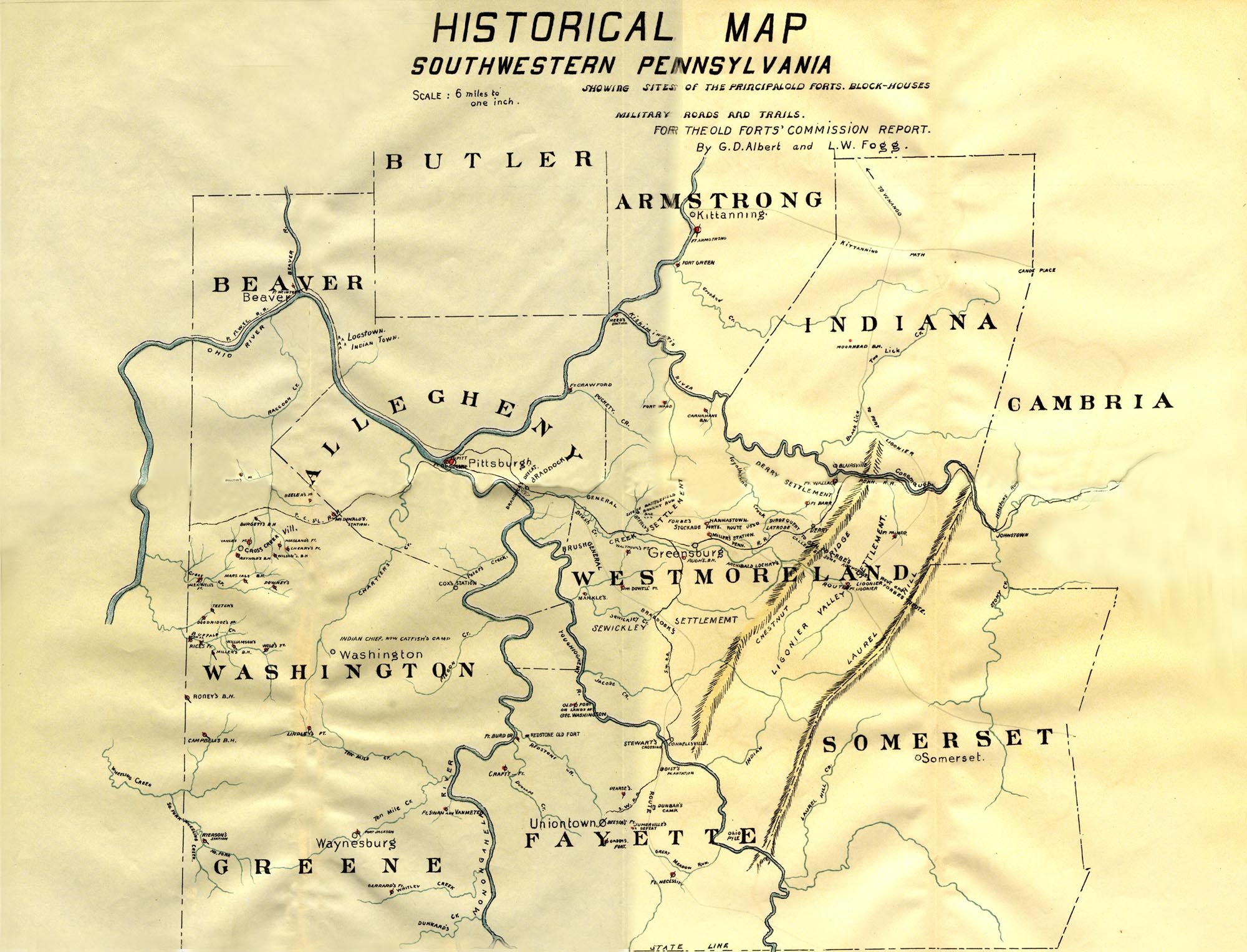
Useful maps:
Historical
Map of Southwestern Pennsylvania, by G. D. Albert & L. W. Fogg
of the Old Forts' Commission Report, Volume II.
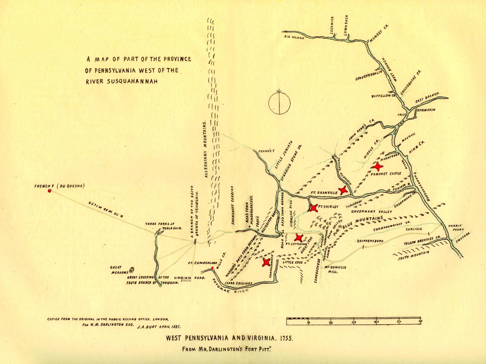
Darlington's
1755 Map
from
"FORT
PITT AND LETTERS FROM THE FRONTIER"
edited by Mary C. Darlington, 1892.
The Historical Map of Pennsylvania places this fort on the north side of the Mahontonga creek, in Snyder county, immediately beyond the dividing line of Juniata and Snyder counties, and in the vicinity of Pomfret Castle, which, perhaps, is often taken for Fort Patterson, but the writer finds much confusion existing relative to the facts aimed at by the different gentlemen of historical attainments and achievements, and hence we must leave its definite time and place of establishment, together with all the attendant circumstances, to the researches which we append.
In the year 1751, James Patterson, with five or six other gentlemen, all being Scotch-Irish, came from Lancaster county and settled in the Juniata Valley at now the town of Mexico, where he took up a large tract of land, lying on both sides of the Juniata river. He proceeded to clear his land, engage in farming and erected a log house, which was afterwards called Fort Patterson, it being used as a place of refuge and defence by the settlers in attacks made upon them by the savages. Patterson was a very daring man and was looked upon by the Indians as a great shot. He used to take a target and lean it against a tree and whenever the friendly Indians came to his house he would take his rifle and begin to shoot at the target, never missing it, the Indians thus making up their minds that he was a very dangerous man and that he had better be let alone. He was, doubtless, a unique character, as we find in the defiance of his manner, with relation to the important transactions of that early period. He lived upon this plantation for a number of years and regarded the Penns as being very uncharitable people because they undertook to exact from him payment for his lands, to which proceeding he very strongly objected, regarding it as a very unchristianlike way of dealing with the pioneer settlers. He claimed that the Penns acquired title to millions of acres of valuable lands for the paltry sum of four hundred pounds, and looked upon the treaty at Albany as devoid of any motive of honesty, and thought, therefore, that he was perfectly justifiable in establishing his own claim. After he had resided in this locality for a long period, hostilities with the Indians became very great, and in fact he was ultimately, as a last resort, compelled to retire from the neighborhood and go into Shearman's Valley, where he remained for some time. After returning to his former plantation, he found his lands parcelled out among others who had gone through the formality of the land office for the purpose of perfecting title to their land. Undaunted by this proceeding which stripped him of all his property, he again took up lands with his mind set upon the determination that he would not pay for any part of it. Being threatened with arrest by the authorities, he nevertheless still maintained that his claim was just and right. After having been called into service by the Provincial government, we gather from data that they forgave any claims which they had against him on this account, and he was permitted to settle upon his lands without any further controversy.
About the time of the trouble between the French and Indians, and after the defeat of General Braddock in 1755, we find there was a fort erected at Mexico, overlooking the Juniata river, and to further authenticate this statement that there was a fort erected there, letters of T. Lloyd under date of October 14th, 1756, show that there was twenty thousand weight of Provincial flour left at Capt. Pattersons,' his place having been used as a base of supplies.
The troubles with the Indians, at this time were becoming
great and we find that Capt. William Patterson, son of Capt. James Patterson was called
to Fort Augusta for the purpose of getting instructions to settle difficulties on the path
through the valley, leading from Fort Augusta, by way of Middle creek on up the valley to
Pomfret Castle, which was supposed to have been located near Patterson's Fort. Thus we find
at this time that the name was recognized as Patterson's Fort.
Whilst on this scouting expedition, after having received his instructions, he fell in with
some Indians at Middle creek, one of which they killed and scalped, put the rest to flight,
and took off their horses; that one of Capt. Patterson's men was wounded; that the woods
from Juniata to Shamokin (probably Fort Augusta, now Sunbury) are full of Indians seeking
for plunder and scalps; that they found many houses burnt and some burning, and that it
was feared that few, in a short time would be left standing, and that all the grain would
be destroyed. "We also hear from the same place, Carlisle, that some Indians have been
seen very lately within seven or eight miles of that town; that Patterson's Fort on Juniata
was fired on several times by them a few days ago, and one Mitcheltree was carried off;
that a few of them had been seen about Granville and Juniata, and that the inhabitants of
Cumberland county, in general, are in greatest distress and confusion imaginable, many of
them leaving their habitations, and not knowing where to go or what to do." These Indians
committing these depredations were known as the Delawares. It is reported that they were
incited by the chicanery and bribery of the French in Canada, who seemed to be largely grieved
about the sale of lands.
Benjamin Franklin gives the following directions to George Croghan in a letter dated December 17th, 1755:
"You are desired to proceed to Cumberland county and fix on proper places for erecting three stockades; namely, one back of Patterson's * * * * * each of them fifty feet square, with a blockhouse on two of the corners, and a barracks within, capable of lodging fifty men." * * * *
The Stump's run massacre which was perpetrated by Frederick Stump, the "Indian Killer," and an accomplice in the year 1768, on the Middle creek, now Snyder county, serves to illustrate the heroic character of Captain William Patterson, and while that massacre will be fully and more particularly treated of in the history pertaining to the forts, etc., in Snyder county, the writer deems it quite essential and relevant to here note that these men, committing this massacre, wholly unprovoked, being only goaded on in their fiendish purpose by the brutal impulses of a selfish and murderous nature, were subsequently arrested by the brave Captain Patterson and a detachment of nineteen men, safely lodged in the jail at Carlisle, but they afterwards escaped the clutches of the law through some disputes arising concerning their trial, and it is stated that Stump never returned to Snyder county, but making his way down into the Virginia country, remained there until his death.
As has been before alluded to in this narrative, Captain James Patterson occupied his land, upon which he subsequently erected Fort Patterson and also built a mill bearing his name, in the vicinity of Mexico, Juniata county, Pennsylvania—that he did this in violation of the rights of the Proprietary government, or without any direct authority from that government, as some authorities have detailed, yet we have the authoritative statement that Captain James Patterson got his warrant for a tract of land containing four hundred and seven acres at Mexico, February third, 1755, and which he had surveyed February twenty-ninth, of the same year, being the first and only tract patented in this county. Hence, the whole story of his bidding defiance to the law and refusing to go through the formalities of the land office for his title would appear to be without the slightest foundation and does the Captain great injustice. We might simply add in conclusion that he was one of the most illustrious pioneer settlers in Juniata county, and deserved the respect and esteem of all the provincial authorities, as was indicated by the many letters which passed to and fro between them.
As near as we can learn by tradition and fact, this
fort was erected on the public road leading from the village of Mexico to the Juniata river
bridge on a commanding eminence, midway between where the old mill now stands and the ruins
of the Pennsylvania canal. Some, however, by tradition, fix it as being immediately in front
of the house and lands now owned by Mr. Porter Thompson. The writer is unable to reconcile
this contrariety of opinion, not being able to accurately ascertain its true location. This
noble and bravehearted pioneer died at this fort and his remains now lie in a grave on the
land owned by Mr. Jerome N. Thompson, Sr.
The confusion of names, dates, localities, etc., presents a field often times of speculation and much uncertainty to him who essays to draw facts from the records of the past, and the writer here adds a note from the late Prof. A. L. Guss, a historian of repute in the Juniata Valley, concerning the two Patterson forts, the two Captains Patterson, James, the father, heretofore referred to, and William, his son, and the much written of and mythical Pomfret Castle: In order to properly locate both these Forts Patterson, Capt. William was located on the opposite side of the river from Mexico on the farm now owned by Byron L. Shuman and their labors in defence of their settlements seemed to go hand in hand. We give Mr. Guss article:
"There were two Capt. Pattersons and two Patterson's Forts, and these have been the means of much confusion Capt. James, the father, lived at Mexico and had a house fitted up for defence against Indians, soon after Braddock's defeat; at all events, it had the name of Patterson's Fort before the close of 1755. Capt. William Patterson lived opposite Mexico, at Byron L. Shuman's place, and had a house fitted up for defence, the logs of which were in position within the writer's memory, but this fort was not built until after the French and Indian war, probably in 1763, and hence is not the one referred to in Colonial Records and Archives and on the maps. The order of the Commissioners, December 17th, 1755, for the erection of forts west of the Susquehanna, designated one of the three to be located back of Patterson's. It was to be on the Mahantongo creek (near Richfield) and was to have been built by Col. Burd and Capt. Patterson. Although the Governor wrote to other Governors that these forts were all finished on January 29th, 1756, yet on February 2d, he hoped it would be finished in ten days; yet it appears from his own letter that this one, which was to be called Pomfret Castle, had nothing done to it yet on February 3d, and on the 9th he again says, ‘It is erected, but on the 14th of June he orders Capt. George Armstrong ‘to build it where it was laid out by Major Burd; and it is doubtful whether any work was ever done upon it. Patterson put up or strengthened his own fort at Mexico, and great confusion has arisen by confounding it with the supposed Pomfret Castle, or rather, it locates them both at Richfield. The same view was taken by the compiler of the State Archives in the article on Forts. The error, perhaps, arose from the directions to Paymaster Elisha Salter, who, on leaving Fort Granville, was directed to go in charge of the guard to Pomfret Castle, or Patterson's Fort. This might mean that the latter was only another name for the former. It may also and in this case does mean hat he is to go to the other place, or the other as circumstances on his arrival pointed out. It was certainly known that the soldiers were likely at Patterson's, at Mexico, and the instruction was that if he learned at Fort Granville that they were still at Patterson's he was to go there. In the text accompanying the Historical Map of Pennsylvania it is stated that Patterson's Fort was built in 1751, and Pomfret Castle built in 1756, both in Snyder county. This is a strange jumble. Patterson's Fort was not built in Snyder, nor in 1751. No man can prove that this, or any other fort in this region, was built at that date. The map gives an Indian path, from Shamokin by way of Pomfret Castle and Mexico, to Mifflintown. This path came to the Delaware run where, it seems, Musemeelin lived in 1744, when he followed and killed Jack Armstrong, and it is said to be the same place that the Dutchman Starr settled. The several relations of the capture of Hugh Micheltree, already given, are also relied upon to prove that Patterson's Fort and Pomfret Castle were the same."
It appears by a letter written by Governor Morris to General Shirley that he and Capt. Patterson were given directions to build Pomfret Castle, but instead of doing this work they had gone to Sugar Cabins, in the vicinity of where Fort Lyttleton was erected and "nothing is yet done." In the meantime murders were occurring as the Indians who committed these murders passed near by where this fort was authorized to be built, the imputation was whether or not a good deal of mischief would be done by their remissness. A short time afterwards, about the 29th day of March, 1756, Pomfret Castle was fired on by a party of Indians who took one Hugh Mitcheltree as their prisoner and as narrated before, this occurred three miles below Patterson's Fort, and as by a subsequent letter by Governor Morris to Col. Armstrong the fort was not built June 14th, 1756, or at least it was not then finished. Hence we infer from the Mitcheltree affair, being but a short distance below the location of Fort Patterson, that Forts Patterson and Pomfret Castle were fruitful sources, in historical research, of the greatest confusion, but from all evidence we can gain, the fact would seem to remain indisputable that the Mitcheltree affair occurred, as Governor Morris says in his letter, "within sight of Patterson's Fort."
In conclusion, the writer begs leave to say that none of the histories of this locality, nor the traditions or memories of the oldest residents in the neighborhood of Richfield, where Pomfret Castle is alleged to have been erected, sustain the theory that ever a fort was erected there known as Pomfret Castle.
In behalf of so faithful a character as this pioneer we submit a sketch prepared by Samuel Evans, Esq., of Columbia, Pennsylvania, which we deem worthy of consideration in the history of the man and of this fort: "Capt. James Patterson, son of James, was born on his father s plantation in Conestoga manor, in 1715, where he remained assisting his father in the Indian trade, and upholding his right to property on the west side of the river with a vigorous hand against the encroachments of Capt. Cresap and his gang of outlaws, who held him a prisoner several times in their fort. He remained with his father until his death in October, 1735. In the same year he married Mary Stewart, daughter of George Stewart, esquire. After his marriage he removed to Donegal. During Cresap's war he frequently shouldered his musket and marched to the relief of the Pennsylvanians, who were sorely pressed by superior numbers from Maryland. He established a trading post upon James Letort's nine hundred acre tract a mile northeast of what is now known as Schock's mill. * * * * * In 1754, Capt. James Patterson, with his brother-in-law, Captain James Lowrey, moved to the Juniata and at about this time, in connection with a number of pioneer settlers, he proceeded to the Valley of the Juniata, where he took up a tract of several hundred acres of land where the present town of Mexico is in Juniata county.
"In the year 1751 he built a fort for the protection of settlers at the mouth of Tuscarora Valley, then the principal crossing used by the Indians in traveling north to Shamokin, or going south to Virginia. Mr. Patterson was not only in constant danger from the attacks of the savages, but he occupied an unpleasant position in relation to the proprietaries of Pennsylvania who refused to give him a patent for his land because the Indian title to it had not been extinguished. In fact, all of the settlers along the Juniata and in the valley south of it were ordered by the Governor and Council to remove from these rich valleys. Capt. Patterson, unlike his father, became very much embittered against the Penns, and refused to leave his settlement. The impending conflict between the French and the Indians soon gave the settlers plenty to do to save themselves, and the authorities at Philadelphia, and the Assembly, after quarreling among themselves and permitting hostile Indians to roam at large along the frontier, without giving the settlers the means to defend themselves, were brought to a realizing sense of their danger by the defeat of Braddock in July, 1755. There was no time then to be quarreling with the pioneer settlers about their land titles. Capt. Patterson probably commanded a company of rangers during the Braddock campaign, attached to the Provincial forces under Capt. James Burd, when they were hewing a road through the forests and over mountains to the Monongahela. After Braddock's defeat he did not flee, like Col. Dunbar, who did not stop with his army until they arrived in Philadelphia, thus exposing the entire frontiers to the attacks of the victorious savages. He hastened with his brave followers to his fort and prepared to defend the settlers. He and his gallant son William, then but a boy, struck back at the Indians whenever they got a chance. On October 2d, 1755, the savages suddenly appeared in Tuscarora Valley, the vicinity of Patterson's Fort, and killed and captured forty persons. Jennie McClain, a young girl then residing with a Mr. Frazer, mounted a horse with a man and fled toward the fort, and when but a short distance from it, the Indian shot the horse through the body, when Jennie fell off the horse and was taken prisoner. The horse sprang forward and carried the man safely to the fort. The Indians surrounded the fort, but the Pattersons defended it bravely and drove them away. Other forts were surprised and destroyed, but the savages were not able by stratagem or superior numbers to capture this one, which stood for many years and was the scene of bloody encounters with the Indians.
"In 1756, Capt. Patterson was under the command of Major James Burd. He assisted in the erection and was in command of Pomfret Castle in 1756. The following is a copy of an original letter written to Major Burd, dated from Fort Pomfret Castle, February 5th, 1756:
"Excuse my not sending a guard according to your request. I have tomorrow morning a detachment of twenty-four men to Carlisle in order to Eschort provisions from thence to my fort. I have sent you Patren of two match coats. I have Purchast two Beeves, one of which I, send you. As for the milch cow, you wrote for, I cannot purchase without cash. The nails and axes I have sent by the men. The rest of the tools I have, I cannot spare."
"In the summer of 1756, Col. John Armstrong destroyed the Kittanning. The French threatened to retaliate upon the settlers, and large bodies of Indians moved upon the West Branch of the Susquehanna river, to be within striking distance of the English settlements. The Governor took immediate measures to build a fort at Shamokin, now Sunbury, which was called Fort Augusta. Capt. Patterson and his company, under direction of Major Burd, marched to Shamokin and commenced its construction. In the spring of 1757 Capt. Patterson was detailed and placed in command of Fort Hunter, five miles above Harris Ferry. In the fall of 1757 he was constantly sending out ranging parties along the base of the mountain toward Robinson's Fort, and up various creeks and across to the Juniata. Lieut. Allen was the only officer he had at the fort and he was often compelled to range with the squad of men twenty-five and thirty miles away from the fort. * * * * * Capt. Patterson continued in command at Fort Hunter and his company furnished ranging parties and the guards for the batteaux fleet under the command of Daniel Lowrey, brother of James, who transported supplies from Harris Ferry to Fort Augusta. * * *
"In the beginning of July, 1758, Capt. Patterson and about three-fourths of the command at Ft. Augusta were ordered to march to Raystown, (Fort Bedford), and join Brigadier Forbes army in their march to Fort Duquesne. Their line of march was probably via Fort Patterson and Tuscarora Valley through Buffalo Valley, Standing Stone, (Huntingdon).
"After the Indians were whipped into subjection, Capt. Patterson returned to his own fort, and gave his attention again to his much neglected land. He did not, however, omit the taking precautionary measures to keep his Fort in good repair, and provided it with the material for defence. The Indians remained quiet until Pontiac's war broke out in 1763, when the savage barbarities were fearful. Capt. Patterson and his son, Lieut. Wm. Patterson, were again on guard. They followed them to their places of concealment, and gave them many hard blows. Capt. James Patterson died at his Fort and is buried in the graveyard on the present property of Jerome N. Thompson, Sr.
______
PATTERSON'S FORT (II.)
Pages 602-605.
This Fort was erected some time about the period of Braddock's defeat, 1755, by Capt. William Patterson, on the land of his father, Capt. James Patterson, opposite Mexico, in the Tuscarora Valley, being a large tract of land at the foot of the mountain, and extending down to the river. The present site of this Fort is now owned by B. L. Shuman and traces of it still remain visible. This stockade or blockhouse was standing until within a few years ago. The land was then in the possession of Mr. Strouse. The stockade was twelve feet square and eight logs high, being protected by a slate roof to guard against fire. The apertures between the logs were filled with stones and loopholes were cut out on a flare, so as to admit of the pointing of a gun in any direction. The building finally served the purpose of a corncrib. Much has been said of this important person in the narrative of Capt. James Patterson, the father and owner of several hundred acres of valuable land in this locality, on part of which land Capt. William Patterson, the son lived and in connection with this brief description we here append some of Mr. Samuel Evans data concerning him: Capt. William Patterson, son of James Patterson, was born in Donegal township, Lancaster county in 1737, and went with his father to the Juniata Valley in 1750. The first act of the old pioneer was to erect a blockhouse, to clear the land and till the soil and make it capable of producing grain and vegetables, which required a good deal of time and labor, before the settlers could make it self-supporting. William Patterson, from the time he came to the valley to the period of old age, was the most expert marksman along the frontier. His father, who was an Indian trader and kept a store at the crossing of the Juniata in the direct line of the travel between the southern and northern Indians, often had large numbers of savages about his store, and he knew from experience that nothing would elicit the admiration or wholesome dread of the white man's power so much as being an expert marksman, and he was certainly excusable for erecting a target about sixty yards from the door of his dwelling. Whenever the Indians made their appearance old Capt. James Patterson or his son William leisurely took down their rifle and stepping to the doorway fired at the target, which they invariably hit in the centre, or very close to it. This astonished the Indians on account of their skill. By resorting to a trick of this kind they were able for a long period to play upon their fears, but about the time of Braddock's defeat the Indians began a general slaughter of the frontier settlers. When his father commanded a company of rangers under Major James Burd making a road over the mountain, William was with him. After his father raised a company and was regularly mustered into the military service under Major, afterwards Colonel, James Burd, William was appointed ensign and marched with his father to Shamokin, where the troops commenced the erection of Fort Augusta, now Sunbury, in 1756. December 12th, 1757, William was promoted for meritorious service to a lieutenant. He was still a minor. For many months he and his father, with details of privates, ranged the mountains and streams in search of Indians. William Patterson not only displayed great capacity as a partisan soldier, but was equally conspicuous in civil life. He marched in advance of General Forbes army to Fort Duquesne in 1758 and participated in the battle of Loyal Hannon, in October, 1758. He also served under Col. Burd, in conveying live stock and subsistence from Fort Cumberland to Fort Burd and Fort Pitt in 1759. After his return from the army, Capt. Patterson seems to have devoted his time to land surveying and the strengthening of his block house on the opposite side of the river to that of his father's, where he located several hundred acres of land. His fine presence and dashing character won the admiration and esteem of the pioneer settler, especially of the young men, who followed the chase and provided game for the large and growing settlements in Tuscarora Valley and around Patterson's Fort.
Pontiac's war coming upon the settlers in 1763, without any previous warning, fort after fort and many private blockhouses were destroyed and the feeble garrisons put to the hatchet or stake, and the imminence of the danger of complete devastation of the entire frontier settlements by the savages, the settlers generally abandoned their newly found homes and rushed into the counties of Lancaster and York to escape the fury of their enemies. Capt. William Patterson called his young hunters around him and bid defiance to the Indians. Pontiac had boasted that no wooden fort or stockade could escape destruction if he desired to destroy them.
When they could not induce the garrison by cunning and lying to surrender, they would load a wagon with straw or hay and set it on fire, and back it against the timbers and let the demon fire do the work. Although Patterson's Fort was surrounded by savages repeatedly, they were driven away or kept a distance by the expert riflemen under the command of Capt. Patterson.
As has been told in the sketch of Capt. James Patterson, William Patterson in 1768, arrested and safely lodged in the jail at Carlisle, Frederick Stump and his accomplice for committing an unprovoked massacre, the victims being Indians. This action required the greatest heroism and firmness of character, but it was safely accomplished and he received the approval of all fair-minded men in and out of provincial authority at the time. The Governor of the Province of Pennsylvania at that period was so highly pleased with the prompt action of Capt. Patterson that he gave him a special commission as justice of the peace, and judge of the common pleas court of Cumberland county. He was also appointed a commissioner to lay out Northumberland county in 1772. Capt. William Patterson is described in the Shippen papers as "a gentleman of limited education, a very good soldier and does his duty well," and is often mentioned in Burd's Journal.
______
MIFFLIN COUNTY.
FORT GRANVILLE.
Page 605-611.
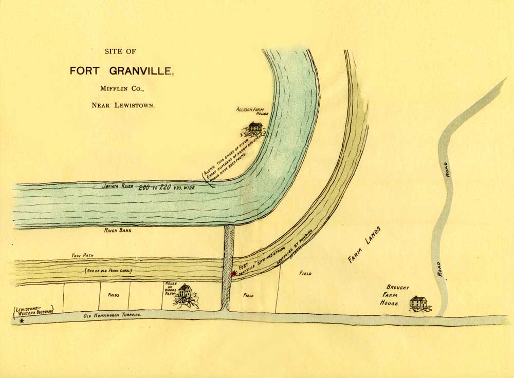
Site of Fort Granville, Mifflin Co., Near Lewistown.
This Fort was erected on the site about one mile west
of where the borough of Lewistown now is, immediately on the north side of the Juniata river
and westward from where the Kishacoquilas creek empties its waters into the Juniata, about
the distance of one mile. The date of its erection was shortly after Braddock's defeat in
the autumn of 1755. It was about a mile west of the present Lewistown, Mifflin county, on
the north bank of the Juniata. There was a spring in the enclosure of the Fort which was
destroyed in making the canal; no remains at present are to be seen of the Fort. The land
upon which this Fort had been located was owned by James Turner, which subsequently became
vested in the Commonwealth of Pennsylvania for the use of the Pennsylvania canal. The digging
of this canal almost obliterated the site as well as the spring, so that the nearest statement
we have of its actual location is that it is one mile above the town of Lewistown or "Old
Town" as it had been called in Provincial times.
This was one of a "chain of forts" erected on the west side of the Susquehanna
and placed about twenty miles from the other forts, and was about fifteen miles northeast
of Fort Shirley at Aughwick, now known as Shirleysburg, in Huntingdon county, Pennsylvania,
and about fifteen miles from Fort Patterson at Mexico. "It was selected because it
commands a narrow pass where the Juniata river falls through the mountains, which is so
circumstanced that a few men can maintain it against a great enemy, as the rocks are very
high on each side and less than a gun-shot from below." This declivity extended for
six miles eastward and westward, so that the enemy could be easily seen in their approaches
from "Every direction." Upon this site so selected, was built the stockade work
which received the name of Fort Granville, and was garrisoned by a company of enlisted men,
under regularly commissioned officers. The work was commenced soon after the order was given
to Captain Croghan that the Fort should be completed and garrisoned during that winter,
as shown by a letter written by Elisha Salter, dated Carlisle, April 4th, 1756.
As early as the date of the old French war of 1755, a few adventurous pioneers from the Scotch-Irish settlements on the Conococheague, had passed up the old Raystown road, and found their way down the Raystown and Aughwick branches to the fertile and lovely valley of the Juniata. Arthur Buchanan, his two sons and three other families, all Scotch-Irish, came to where Lewistown now stands and pitched his tent and took up land where Lewistown now stands, in the year 1755. Buchanan was a man of great force and energy, who loved to roam in the woods far from the habitations of men. His cabin stood near the mouth of the creek about where the canal bridge stood in the times when the packet was the mode of transportation in those early days. As before stated, this frontiersman had several sons, one of whom became distinguished as Col. Buchanan. After the location of this settler, Buchanan, he called upon the Indians and signified his intention to purchase lands. They were at first unwilling to sell, but Capt. Jacobs, as Buchanan christened the chief, because of his close resemblance to a burly German in Cumberland county, who was the head chief, having been liberally plied with liquor, decided that Buchanan should have the much coveted land. What was paid for it has never been divulged, but it is more than probable that the contents of his rum keg, a few trinkets, and some tobacco made him the sole possessor of this soil.
After the defeat of General Braddock, the Indians made sudden incursions upon all parts of the unprotected frontier. The attack upon Fort Granville was made in harvest time of the year 1756. The Fort at this time was commanded by Lieut. Armstrong, a brother of General Armstrong, who destroyed Kittanning. The Indians, who had been lurking about this fort for some time, and knowing that Armstrong's men were few in number, sixty of them appeared, July 22d, before the fort, and challenged the garrison to a fight; but this was declined by the commander in consequence of the weakness of his force. The Indians fired at and wounded one man, who had been a short way from it, yet he got in safe; after which they divided themselves into small parties, one of which attacked the plantation of one Baskins, near the Juniata, whom they murdered, burnt his house and carried off his wife and children. Another made Hugh Carroll and his family prisoners.
On the 30th of July, 1756, Capt. Edward Ward, the commandant of Granville, marched from the fort with a detachment of men from the garrison, destined for Tuscarora Valley, where they were needed as guard to the settlers while they were engaged in harvesting their grain. The party under Capt. Ward embraced the greater part of the defenders of the fort, under command of Lieut. Edward Armstrong. Soon after the departure of Capt. Ward's detachment, the fort was surrounded by the hostile force of French and Indians, who immediately made an attack, which they continued in their skulking, Indian manner through the afternoon and following night, but without being able to inflict much damage on the whites. Finally, after many hours had been spent in their unsuccessful attacks, the Indians availed themselves of the protection afforded by a deep ravine, up which they passed from the river bank to within twelve or fifteen yards of the fort, and from that secure position succeeded in setting fire to the logs and burning out a large hole, through which they fired on the defenders, killing the commanding officer, Lieut. Armstrong, and one private soldier and wounding three others.
They then demanded the surrender of the fort and garrison, promising to spare their lives if the demand was acceded to. Upon this, a man named John Turner, previously a resident in the Buffalo valley, opened the gates and the besiegers at once entered and took possession, capturing as prisoners twenty-two men, three women and a number of children. The fort was burned by the chief Jacobs, by order of the French officer in command, and the savages then departed, driving before them their prisoners, heavily burdened with the plunder taken from the fort and the settlers houses which they had robbed and burned. On their arrival at the Indian rendezvous at Kittanning, all the prisoners were cruelly treated, and Turner, the man who had opened the gate at the fort to the savages, suffered the cruel death by burning at the stake, enduring the most horrible torment that could be inflicted upon him for a period of three hours, during which time red-hot gun barrels were forced through parts of his body, his scalp was torn from his head and burning splinters were stuck in his flesh until at last an Indian boy was held up for the purpose who sunk a hatchet in the brain of the victim and so released him from this cruel torture.
In a letter from General Armstrong to Robert Hunter Morris, dated Carlisle, August 20th, 1756, we find the following relating to this fort; it was claimed that Peter Walker was taken a prisoner at this fort by the French and Indians, who, with others, afterwards made his escape: "This McDowell told Walker they designed very soon to attack Fort Shirley with four hundred men. Capt. Jacobs said he would take any fort that would catch fire, and would make peace with the English when they had learned him to make gun powder. McDowell told Walker they had two Indians killed in the engagement; but Captains Armstrong and Ward, whom I ordered on their march to Fort Shirley to examine everything at Granville and send a list of what remained among the ruins, assure me that they found some parts of eight of the enemy burnt, in two different places, the joints of them being scarcely separated; and part of their shirts found through which there were bullet holes. To secrete these from the prisoners was doubtless the reason why the French officer marched our people some distance from the fort before he gave orders to burn the barracks, &c. Walker says that some of the Germans flagged very much on the second day, and that the lieutenant behaved with the greatest bravery to the last, despising all the terrors and threats of the enemy whereby they often urged him to surrender. Though he had been near two days without water, but little ammunition left, the fort on fire, and the enemy situate within twelve or fourteen yards of the fort under the natural bank, he was as far from yielding as when at first attacked. A Frenchman in our service, fearful of being burned up, asked leave of the lieutenant to treat with his countrymen in the French language. The lieutenant answered, "The first word of French you speak in this engagement, I'll blow your brains out," telling his men to hold out bravely, for the flame was falling and he would soon have it extinguished; but he soon after received the fatal ball. (Col. Rec., Vol. ii, pp. 232.)
We hereto append the deposition, or so much as is pertinent, of John Hogan, one of the escaped prisoners, which was taken before Col. Armstrong and is as follows: "Cumberland county, June 1st, 1757, before me, John Armstrong, Esquire, one of his Majesty's justices of the peace for the county of Cumberland aforesaid, came John Hogan, late a soldier belonging to Capt. Edward Ward's company of Foot in the pay of the Province of Pennsylvania, who declares and says that on or about the first day of August he with several others was taken prisoner at Fort Granville by a party of French and Indians—consisting of one hundred Indians and fifty French— who took him and the rest of the prisoners to Kittanning, where they were about three hours, at which time John Turner, one of the prisoners, was burnt. They were then taken down the river to Fort Duquesne where they were a few hours; the French and Indians not agreeing; where they proceeded to Logstown where he continued until he made his escape. And this deponent further says that the Indians sold a prisoner to the French for which they received a nine-gallon keg of brandy. The deponent states that he and George Hily another prisoner considered this a good time to escape, because it was customary for the Indians on such occasions to get drunk and have a frolic, which they did whereupon they set off and brought with them Martin Borrowelly, another prisoner, and arrived at the south branch of the Potomac in three weeks from the time of their escape. Sworn at Carlisle the first day of June, 1757, before John Armstrong."
The Indian massacres of the summer of 1756 closing with the capture of Fort Granville and its garrison, struck terror to the hearts of the pioneers of the region west of the Susquehanna and caused the precipitate abandonment of the settlements along the Blue mountains northward and westward to the West Branch. From this Valley a stream of fugitive settlers with their families retired for safety to Fort Augusta, and thence eastward to their former homes, while those who had located themselves along the Juniata and in the valleys of its tributaries, fled for their lives across the mountain and took refuge at Carlisle and Shippensburg. The inhabitants of York county were very much alarmed and they all complained since the capture of this fort that their prospects for safety and protection had vanished, finding one of the best forts upon the frontier burned and destroyed and many of the men carried into barbarous captivity. A year ago there were three thousand men fit to bear arms in that county, they were certain they did not now amount to one hundred and that never was there a more abundant harvest. The burning of Fort Granville by the Indians being in harvest time, many of the farmers abandoned their plantations and left what corn was then stacked, or in barns to perish on the ground. Immediately after the Fort Granville affair, the whites retaliated with vigorous and incisive measures, Col. Armstrong, with a large force marching westward on his famous Kittanning expedition, the Indian stronghold situated where the present thriving town of the same name is, forty-five miles above Pittsburgh. Kittanning was attacked at daybreak, September 8, 1756, and, in revenge for the destruction of Fort Granville and other atrocities, was completely destroyed, its houses and huts being burned, while a large number of the Indians were killed, among them, it is averred, Capt. Jacobs, though this is a mooted question. The severe blow dealt by Col. Armstrong had the effect to render the Indians less bold and aggressive and to withdraw many of the Delawares from the French lines. The negotiations with Teedyuscung and the eastern Delawares, also, had a favorable effect; but the bands of Capt. Jacobs, and other western Delawares and Shawanese who still remained in league with the French, continued their murdering and burning raids wherever exposed white settlements could be found, until 1758, when the treaty of Easton brought peace once more to the harrassed frontiers of Pennsylvania. Thus many of the settlers who had fled in terror during the bloody summer and fall of 1756 came back to reoccupy their lands which they then were enabled to enjoy with comparative freedom from any molestation whatever, until 1763 when the artful plots of the western chief, Pontiac, began to exhibit themselves and thus bring about another period of bloodshed and horror.
______
PERRY COUNTY.
FORT ROBINSON.
Pages 611-618.
This was variously spelled, Robison, Robeson and Robinson —we prefer the latter.
Data concerning this fort are quite meagre and rather difficult to obtain. There is no mention made of it in the volume of the Pennsylvania Archives, especially devoted to a history of the early fortifications, in Pennsylvania, when the pale face fled almost helpless and defenceless from his more warlike and relentless forest neighbor—the Indian; nor does it find a place on The Historical Map of Pennsylvania, although the name of "George Robinson" appears thereon, at the confluence the the Juniata river and the Buffalo creek, south of the Tuscarora mountain, Perry county, 1754. While we are led to the conclusion, therefore, that this place was not a fort under the direction or control of the provincial authority, there is, nevertheless, sufficient reliable information at hand to warrant the writer in placing it in the same category with the other long line of well established fortifications in Pennsylvania, finding their historical authenticity well founded in the patient and accurate researches made by our historians.
The Robinson family figured prominently in the trials of early pioneer life, a brother of George Robinson who located this stockade or fort was a member of Col. Armstrong's expedition, as well as one of the early pioneers of Shearman's valley.
The early settlers, being harrassed by predatory bands of Indians, this fort was erected by the Robinson brothers, the warrant of the land upon which it was built, being in the name of George Robinson. The fort was built in 1755, in what is now Haines township, Perry county, Pennsylvania, on lands now owned by Adam Roy. From a narrative of Robert Robinson, the history of this fort is gathered. The fort was evidently more of the nature of a blockhouse than anything else and was surrounded by a stockade. This family here at least, for a period of nine years occupied the land before securing a warrant for it. Another important fact connected with the history of this place, is that it was on the line of the traders path from Harris Ferry westward, to Fort Bingham, in Juniata county, located at the base of the north side of the Tuscarora mountain. From the best information obtainable, it is certain that this path extended from the Conococheague settlement, through Croghan's Gap, into Shearman's Valley, thence westward, leading to a point at Bingham's Fort, in Juniata county.
The fort was of easy access from every direction and from the number mentioned by Robert Robinson as being in the fort during the harvest of 1756, we can safely infer that not only the settlers of Shearman's Valley themselves sought the security of its friendly walls, but many of those living in the Tuscarora Valley. From 1756 to 1761 settlers were frequently driven to it for protection. To further show the importance of this point, we have the following from the Provincial Records, as has already been shown in this article and to be followed by other facts.
In the year 1754 Conrad Weiser called at the house of Andrew Montour, who lived in Shearman's Valley, on his way to Aughwick to hold a Treaty with the Indians. And in his Journal says:. "September 1st, crossed the Kittatinny mountain at George Croghan's (Sterrett's) Gap, and Shearman's creek and arrived that day at Andrew Montour's accompanied (from Harris Ferry) by himself, the Half-King, and another Indian, and my son. I found at Andrew Montour's about fifteen Indians, men, women and children; and more had been there, but had gone." The next day, Weiser, accompanied by Andrew Montour and those who were with him before, went toward Aughwick.
Toward the close of December, 1755, the Indians committed some murders in Shearman's Valley.
The following is an extract from the Narrative of Robert Robinson, as contained in Loudon's Narratives, pp. 171 and 2: "The next I remember of was in 1755, the Woolcomber's family on Shearman's creek; the whole of the inhabitants of the Valley was gathered at Robinson's, but Woolcomber would not leave home, he said it was the Irish [Scotch-Irish] who were killing one another, these peaceable people, the Indians, would not hurt any person. Being at home and at dinner, the Indians came in, and the Quaker asked them to come and eat dinner, an Indian announced that he did not come to eat, but for scalps; the son, a boy of fourteen or fifteen years of age when he heard the Indian say so, repaired to a back door, and as he went out he looked back, and saw the Indian strike the tomahawk into his father's head. The boy then ran over the creek, which was near to the house, and heard the screams of his mother, sisters and brother. The boy came to our Fort (Robinson) and gave us the alarm; about forty went to where the murder was done and buried the dead."
Sometime in the month of July, 1756, the Indians appeared again in Shearman's Valley, and abducted Hugh Robinson. "I was," says Robinson," taken captive by the Indians from Robinson's Fort, in Shearman's Valley, in July, 1756, at which time my mother was killed; I was taken back to their towns, where I suffered much from hunger and abuse; many times they beat me most severely, and once they sent me to gather wood to burn myself, but I cannot tell whether they intended to do it, or frighten me; however, I did not remain long before I was adopted into an Indian family, and then I lived as they did, though the living was very poor. I was then fourteen years of age; my Indian father's name was Busqueetam; he was lame in consequence of a wound, received by his knife in skinning a deer, and being unable to walk, he ordered me to drive forks in the ground and cover it with bark to make a lodge for him to lie, but the forks not being secure, they gave way, and the bark fell down upon him and hurt him very much, which put him in great rage, and calling for his knife, ordered us to carry him upon a blanket into the hut, and I must be one that helps to carry him in; while we were carrying him I saw him hunting for the knife but my Indian mother had taken care to convey it away, and when we had got him again fixed in his bed, my mother ordered me to conceal myself, which I did; I afterwards heard him reproving her for putting away the knife; for by this time I had learned to understand a little of their language. His passion, however, wore off, and he did very well for the future . . . . .
"Having now been with them a considerable time, a favorable opportunity offered me to regain my liberty. My old father Busqueetam lost a horse, and he sent me to hunt for him. After searching some time I come home and told him that I had discovered his tracks at considerable distance, and that I thought I could find him; that I would take my gun and provisions and would hunt three or four days, and if I could kill a bear or deer I would pack home the meat on the horse. Accordingly, I packed up some provisions and started for the white settlements, not fearing pursuit for some days, and by that time I would be out of the reach of the pursuers. But before I was aware, I was almost at a large camp of Indians by the creek side. This was in the evening and I had to conceal myself in a thicket till it was dark, and then passed the camp and crossed the creek in one of their canoes. I was much afraid that their dogs would give the alarm, but happily got safe past. I traveled on for several days, and on my way I spied a bear, shot at and wounded him so that he could not run, but being too hasty, ran up to him with my tomahawk; before I could give him a blow he gave me a severe stroke on the leg which pained me very much, and retarded my journey much longer than it otherwise would have been.
"However, I traveled on as well as I could, till I got to the Allegheny river where I collected some poles with which I made a raft and bound it together with elm bark and grape vines, by which means I got over the river, but in crossing I lost my gun. I arrived at Fort Pitt in fourteen days from the time of my start."
In the same year Robert Robinson in his Narrative states that there was a murder committed by the savages in close proximity to this fort, given in the following language: "I forgot to give you an account of a murder done at our own fort in Sherman's Valley in July, 1756. The Indians waylaid the fort in harvest time, and kept quiet until the reapers were gone; James Wilson remaining some time behind the rest, and I not being gone to my business, which was hunting deer for the use of the company. Wilson standing at the fort gate, I desired liberty to shoot his gun at a mark, upon which be gave me his gun and I shot. The Indians on the upper side of the fort, thinking they were discovered, rushed on a daughter of Robert Miller and instantly killed her, and shot at John Simmeson; they then made the best of it they could and killed the wife of James Wilson and the widow Gibson, and took Hugh Gibson and Betsy Henry prisoners. The reapers, being forty in number, returned to the fort, and the Indians made off. While the Indian was scalping Mrs. Wilson, the relator shot at and wounded him, but he made his escape."
"There was another war in July, 1763. The Indians came to Juniata, it being harvest time, and the white people were come back to reap their crops; they came first to the house of William White; it was on the Sabbath day; the reapers were all in the house; the Indians crept up nigh to the door and shot the people lying on the floor, and killed William White; and all his family that was there, excepting one boy, who, when he heard the guns, leapt out of the window and made his escape.
"This same band of Indians took their course toward Robert Campbell's on Tuscarora creek where they surprised some of the settlers, following up their course as far as Bingham's Fort. The brave Robinson brothers, having a number of friends along this path, were fearful lest they should be surprised by the Indians lying in ambush, followed. They organized a band of twelve, composed of William Robinson, who acted as captain, Robert Robinson, the relator of this narrative and Thomas Robinson and a number of other settlers in the vicinity of Sherman's creek, all of whom went over for the purpose of protecting them. They divided their force into two companies of six men each. They followed the tracks of the Indians and found where they had committed depredations, burned down buildings and murdered some of the inhabitants. They came into contact with them at Nicholson's, across the Tuscarora mountain and had a severe engagement with them in which five of their number were killed and one wounded. The persons killed being William Robinson, who was shot in the stomach with buckshot and got about half a mile from the ground. Not far from this spot William Robinson was weltering in his blood, says the relator, and in his last agonies he requested when I appeared that if ever I had opportunity to kill an Indian to do it for his sake. Thomas Robinson stood on the ground until the whole of his people were fled, nor did the Indians offer to pursue him until the last man had left the field. Thomas having charged and fired a second time the Indians were prepared for him, and when he took aim past a tree, a number fired at him at the same time; one of his arms were broken, he took his gun in his other and fled, going up a hill where he came to a high log, and clapped his hand in which his gun was, on the log to assist in leaping over it, while in the attitude of stooping a bullet entered his side, going in a triangular course through his body, he sunk down across the log; the Indians sunk the cock of his gun into his brains and mangled him very much."
Thus ended this unfortunate affair to those engaged, but at the same time it appears as if the hand of Providence had been in the whole transaction; for there is every reason to believe that spies had been viewing the place the night before and the Indians were within three-quarters of a mile of the place from which the men had started, where there would have been from twenty to thirty men, perhaps, in the field reaping and all the guns that could be depended on were in this small company, except one, so that they might have become an easy prey, and instead of those five brave men who lost their lives, three times that number might have suffered. As to the men described above we can only conjecture, which pleasure is left to the indulgent reader. Whether the two brothers murdered on Buffalo creek are buried here, history is also silent. It is however, altogether probable that they are, and likewise Miss Miller, Mrs. James Wilson and the widow Gibson, who were killed, as stated above, during the harvest of 1756.
From the number of volunteers it can safely be conjectured that the capacity of the fort was considerable. Of this fort traces yet remain. The tradition of the oldest inhabitants clearly locates it in the orchard back of Mr. Loy's house and not far from the high bank overlooking the stream. To further show the desperate straits into which the pioneers of that locality, in the vicinity of this fort, were driven, we have evidence in the brief but incontrovertible fact that on the thirtieth of July, 1756, Captain Ward left fort Granville, with all his men except twenty-four under the command of Lieut. Armstrong to guard some reapers in Shearman's Valley. Whilst, therefore, this fort was not erected under provincial authority, nor manned by it, yet, owing to the fact that it was on or near the important path leading from the Conococheague settlement to the westward, through Sterrett's Gap by Bingham's Fort, on to Aughwick, it was used very largely by the early pioneers and settlers moving westward, and would also tend to establish the belief that the settlement in Shearman's Valley was an important one at that early day.
Fort Robinson was a great rendezvous for all those who traveled westward, the hospitality of the Robinson family being very great, and all who traveled by it had extended the comforts and security which such a place held out to them in those times. It appears from history that a great many Indian depredations were committed in that locality, that the settlers were in constant danger of their lives, that they were unable safely to gather their harvests, in consequence of which and doubtless facing the countless other exigencies common to the lot of the pioneer settler, George Robinson erected this fort.
That it was not under Provincial authority, is further proven by the fact that it was not garrisoned by troops furnished by the government then, nevertheless they undertook, at their own expense, these few intrepid men, to protect themselves and harbor their people in the enemy s country. They were compelled to rely entirely upon their own unaided efforts for security and protection, not being furnished, as was the custom with regularly established garrisons, on behalf of the government, with powder, lead and firearms. We also have the fact that Conrad Weiser was sent into Shearman's Valley to meet the men there and to confer with Andrew Montour concerning the settlement of Indian troubles, thus making it, in the light which we have, a very important post.
Could there be a place in our Commonwealth more worthy of the fostering care of her people?
______
SNYDER COUNTY.
HENDRICKS' FORT—A BLOCKHOUSE.
Page 618-621.
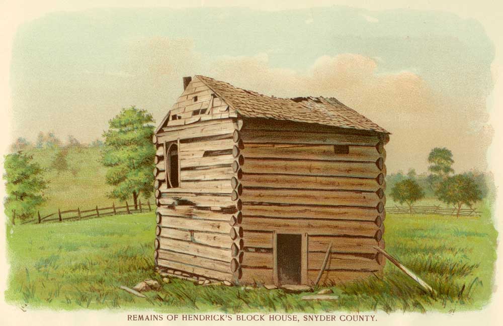
Remains of Hendricks' Block House, Snyder County.
This fort or blockhouse was erected as nearly as can be ascertained, from information gathered from the oldest citizens in the community of its location, about the year 1770. It stands in Middlecreek township, Snyder county, Pennsylvania, within a stone's throw of the public road leading from Selinsgrove to Lewistown, and but a few rods west of Samuel Rumbaugh's hotel. It is on the south side of the road and built over a very fine spring of water. The tract of land on which it stands belongs to Mr. Charles Keck, of Kreamer, Pennsylvania. The land is in the nature of a meadow and for over one hundred years this fort or blockhouse has stood upon its well built foundation of stone in what might be called a morass, in which weeds, tall grasses and the long, green blades common to low lands thrive abundantly. Its location is about one-half mile due south of the scene of the Stock massacre, which occurred in this township in the year 1781, whereby four or five persons lost their lives through the fiendish acts of the Indians.
This fort is supposed to have been built by the Hendricks , a bold and energetic people living in that locality, at that early day, some of their offspring still residing thereabouts. It was a place or refuge for the settlers in times of trouble with the redskins, and the people living there now point out the location of two early houses built by the settlers, near here, from which they invariably repaired in the evening or at nightfall to the fort for the purpose of passing the night in security and safety from the attacks of the Indians. The fort is strongly built, having a floor of very stout planks running across it about six feet from the earth. On this floor the settlers gathered themselves and fired through two loopholes not far from the roof, in case of an attack. On the west side of it there is an immense chimney of stone starting at the base with a very wide foundation and taking up about half of the entire western side of the building. The chimney was heavily plastered with something resembling mortar—a yellow clayey substance—which can still be seen sticking to the stones and it has been decorated in an ingenious fashion by the hand of some inventive painter who sought, before this mortar became dry and hard, to ornament it somewhat, with lines running parallel and again at right angles with each other.
A view is herewith appended of this blockhouse, which is still in a very good state of preservation, the timbers used in its construction being of the very best, but one or two logs showing any signs of decay after a lapse of over one hundred years of exposure to the elements. The owner of this property, Mr. Keck, an old gentleman, is willing that the fort should be properly marked and is liberally inclined with regard to such project, he being anxious to have it remain a monument to the times and privations which have passed by, and any effort on behalf of the State to place the same in a condition of permanent preservation will receive his liberal and generous approval. This fort has been variously used as a spring house, tobacco house, etc.
In connection with what meagre data we have at hand relative to this fort, the writer must not omit to make, mention of the massacre of the Stuck, or Stock, family, which was perpetrated here in the year 1781. Mr. Matthias Dauberman, a life-long resident or this locality and whose residence is due north of where Fort Hendricks now stands, perhaps, one-half mile or thereabouts, narrates through Mr. William K. Miller that he heard his grandfather frequently detail the incidents of this horrible massacre, when he, the present Mr. Dauberman, was but five years of age. His grandfather was an eye witness, so to speak, of the affair, and lived east of where the Stucks lived, the second house, about one-fourth of a mile. It appears the men were in the fields at work when some Indians who had been lurking in the woods nearby, swooped down upon the small log house and attacked the defenceless women and children. They killed outright old Mrs. Stuck and two of the children and also a man who happened to be near. They then dragged away with them young Mrs. Stuck, wife of one of the Stuck boys. She was so much terrified with what she had beheld that she fainted when but a short distance from the house and, after reaching the woods beyond the cleared fields, they dragged her a considerable distance into the thicket, where the Indians killed and scalped her.
The entire neighborhood became aroused at the sudden onslaught and they immediately resolved upon pursuit. At that time there lived in the neighborhood of what is now known as the Shamokin Dam, three brave and experienced Indian fighters by the name of Grove, Pence and Stroh, and, with the assistance of these men, the settlers immediately followed the fleeing savages. They were captured in the course of a few days while sitting about their fire in the forest, having made off in the direction of the New York border, and all who are supposed to have had a hand in this butchery were killed by the Indian fighters above named and the settlers who were with them.
Mr. Dauberman relates that he heard his grandfather state that the young Mrs. Stuck, who was dragged into the woods, was not discovered until some days afterwards, when the dogs discovered her and began to feast upon her decomposing flesh, thus betraying the place of her repose, when her remains were gathered up and given appropriate sepulture. The narrator of these particulars, Mr. Dauberman, is now seventy-five years of age, tall and vigorous in frame, with a ruddy countenance and a memory as bright and keen as we might expect to find in a man who has spent his life in the peaceful pursuits of the husbandman, and ever in close touch with nature.
______
McKEE'S FORT.
Page 621-627.
With regard to the time of the erection of this fort and its precise location, history is somewhat at variance. Some writers have attempted to place it on the east side of the Susquehanna river. From data at hand which will be subsequently treated of, the probabilities are that its location was upon the west side of the Susquehanna river. The writer feels perfectly assured, from all the evidence there is upon this subject, that it was more likely that this fort was placed on the west of the river, than upon the east side of it. The Historical Map of Pennsylvania, hitherto referred to, places it on the Northumberland side and gives the date of its location as the year 1756, but we have before found occasion to question the entire accuracy of this publication as to dates, times, etc., being sustained in such criticisms by indisputable authority.
Thomas McKee, we find was an Indian trader who located at the falls (now called McKee's one-half falls) in 1744. He was one of a party of traders who discovered the body of Jack Armstrong who was murdered at what is now Mt. Union. He may have resided at this place at that time but it was not certainly known. But upon the opening of the land office in 1755, Thos. McKee took out a warrant March 5th, 1755, for a large tract of land beginning below the mouth of the Mahontonga creek and which extended along the river above, embracing the Half Falls. To further establish this fact, the title papers, now in the possession of J. L. Weiser, at Mahontonga, J. B. Hall and John S. Rine, now owners of this land, show that it was originally owned by Thos. McKee, being a most significant fact tending to give the location of this fort or post at McKee's Falls, which is now known as McKee's Half Falls. An Indian path ran across the plantation, which was known as McKee's Path. It extended from Shamokin, now Sunbury, to the Juniata river, and touched the Susquehanna at the mouth of the Mahontonga creek and crossed westerly to the mouth of Delaware run, near Thompsontown, on the Juniata river.
The plantation taken up by Thomas McKee was evidently extensive in its area, embracing many acres of land of the most fertile soil along the Susquehanna river. The country being an open one from Fort Halifax, on the east side of the river, up to McKee's Falls, where Thos. McKee was located (on the west side), it is altogether probable that the fort had a better location on the west side of the river on account of the place being more accessible to garrison or troops going from one fort to another. The topography of the country hereabouts would also be a significant factor in determining the location. The country, at many places on the west side of the river, extending back in width several miles before the hills were reached, so that an approach by the enemy could be more easily detected for a considerable distance around, the land being very level and fertile along the western side of the river from here on down to a point opposite where Fort Halifax was situated.
The argument, therefore, of selecting fertile soil and many acres of it in extent, as his place of abode, would seem to outweigh any assertion that he had chosen the eastern side, where the land is bluffy and not adapted to agriculture, and where troops and garrison would find less convenient place.
On the western side, also, the writer knows that there have been dug up the remains of the red man in large quantities. It is stated and the statement would seem to be supported, that there was here, in this vicinity an Indian burial ground, the many remains, such as bones, arrows, Indian implements of almost every fashion going to substantiate this assertion, and Thos. McKee must at some time have held title to these lands, now held by the Weisers, the Halls, the Rines, as appears in subsequent conveyances of the real estate on the west side of the Susquehanna river.
In order to further negative the statement that the fort was located on the east side of the river, we present the fact that the letters passing between the Provincial authorities and Thomas McKee show that there was a fort in existence or mentioned in such letters as early as 1756. And we find that eleven years later than this period he was granted a patent for four hundred acres of land across the river, in Northumberland county. This fact would not dispute his ownership to the land previously taken up on the west side of the river and would also tend, by reason of the priority of time in acquiring lands on the Snyder county side, to establish more firmly the belief that his fort was erected upon the plantation first owned, as all history proves that the means of defence against the raids of the savage were first provided for and it is, hence, unlikely that McKee would live hereabouts for this length of time without erecting some fortification to protect himself against the hostile Indians.
The Sechrist meadows, as they were later on patented, were his. The Sechrists are a large and influential people, now living in the vicinity of, McKee's Half Falls, postoffice, in Snyder county. These meadows were sold by McKee to the Sechrists, as appears by patent of July 26, 1767, executed to Jacob Sechrist. The three islands in the river - Shuman's, of one hundred acres; Hays', of seventy acres, and Kline's (now Yeager's), of eighty acres, were included in this warrant. One hundred and fifty acres of land above the Half Falls tract was sold to Rudolph Smelzer, August 7, 1766.
In order now to come back to the Provincial records in establishing the fact that the fort was built by Thomas McKee, we find the matter referred to in the history of the other forts south of it on the Susquehanna river, McKee's Fort being placed about twenty-five miles above Fort Hunter. As is contained in instructions to Thomas McKee, in a letter dated January 26th, 1756, we have: "You are to receive from the officer now commanding the detachment of Capt. Reed's company at Hunter's Mill, and who you are to relieve, such arms, accoutrements, blankets, tools and stores as he may have in his hands, belonging to the Province, with which you are to furnish your company, but if that be not sufficient, you are to apply to Capt. Frederick Smith for a further supply out of what he will receive from Capt. Reed and Capt. Hendricks." And, again, we find him appointed under a commission as captain of a company to consist of twenty-eight men and two sergeants, besides himself and lieutenant, and is instructed to proceed immediately to raise the company; when complete, they are to be mustered before James Galbraith, Esquire, and, after being mustered, they are to march to a place called Hunter's Mill, on the Susquehanna, and either complete the fort already begun there or build another at such convenient place as James Galbraith shall advise, and in case it should be thought necessary to erect a new fort, you are to build it of the form and dimensions herewith given you.
The next important data we have is a letter dated Lancaster, April 19, 1756, from Edwin Shippen to Governor Morris, in which he states, "I have been at Capt. McKee's Fort, where I found about ten Indians, men, women and children; three of the women lying very ill in bed. The Captain tells me that John Shekellamy is greatly dissatisfied with being there, and has several times been out of temper, which he would hope was owing to nothing but the sickness of the Indians, and to their being often insulted by the fearful ignorant people who have sometimes told Shekellamy to his face, that they had a good mind to scalp him. Shekellamy informed me that he wished the Indians would be moved down where Capt. McKee's women and children were and afterwards, if the Governor thought proper he would go to Wyoming and endeavor to bring down a Shawanese captain, who would have come with him, but the Delawares would not permit it. At the council at Wyoming, whither your Honor sent Silver Heels and The Belt to know why the Indians struck their brethren, the English. This Shawanese captain observed that it was not more than one year and a half since he had taken the Governor by the hand and heard everything that he said and why he should so soon forget him. That he was sitting between the Six Nations and the Governor, takes one in each hand."
"That council consisted of Shawanese, Chickasaws, Mohickans and some of the Six Nations, and Shekallamy ,was appointed to give the answer, who spoke and said: 'You, my young brothers, the Shawanese, it may be, know the reason of striking the English, as you are always in council with the Delawares.' 'No,' answered the Shawanese, speaking to the Six Nations, saying, 'Old brothers, ,we cannot tell why the hatchet was taken up against the English, but you know the reason of it, who are always with them at General Braddock's battle.' Shekallamy says: There are about four hundred Indian Warriors at Tioga, of the Six Nations, Delawares, Munsees and Shawanese, and about forty more at Wyoming. He says if we attempt to go up to Shamokin to build a fort, we may expect to be attacked by a body of five hundred Indians in our march.
"According to your Honor's instructions to Mr. Burd, I have prevailed with Shekellamy to stay where he is until we can hear again from your Honor. I pity the sick Indians much because there is neither sheep, calves or poultry to be got in that part of the country, though game is very plenty; yet the Indians dare not venture out of the fort for fear of being murdered, and the captain informs me that the garrison has been poorly served, the provisions having been very ordinary but they are now a little better used, yet he would fain believe the persons employed about them do their best, he finds that one pound of Burlington pork will go as far as two pounds made in that country.
"John Harris has built an excellent stockade around his house, with a good cellar room, which is the only place of security that way. He has but six or seven men to guard it, and if the government would order six men more there, it would, in my opinion, be of great use to the cause, even were no provision to be stored there at all, though there is no room for any scarce in Capt. McKee's fort. . . . . .
"Without this small addition of men above-mentioned, and the Indians should destroy it, the consequence would be that most of the inhabitants within twenty miles of this place would immediately leave their plantations. The enemy can come over the hills at five miles distance from McKee's fort. But, notwithstanding all I have said on this head, I am convinced that the number of stockades set up and down the country do more hurt than good.
"By the best intelligence I can get, it will be best for Col. Clapham to march his regiment on the west side of the Susquehanna, after first marching eight or nine miles on this side; the only difficulty will be in crossing the river. I know there are several bad passes, as far as Capt. McKee's plantation, where I have been; it is but twenty-five miles from Hunter's Mill."
And here comes the point that is important in the location of this fort. As stated before, the country on the west side of the river being the most accessible for a garrison to march between these points up and down the Susquehanna with no obstructions, it is all the more likely and convincing that Fort McKee was located where McKee's Half Falls now is.
"I ought to have acquainted your Honor before that I have cautioned Capt. McKee against suffering anybody to abuse the Indians for the future, and by all means advised him to keep a straight watch over the young Frenchman whom he has under his care. * * * *
In 1749, Conrad Weiser, on his way to Shamokin with a message from the Governor, met the sons of Shikellimy at the Trading House of Thomas McKee, which he delivered to them there, because he had been informed that all the Indians were absent from Shamokin.
The following letter from Conrad Weiser establishes also, and is confirmatory of the fact that there must have been a fort at McKee's, because he states that he happened to meet the eldest and youngest son of Shikellimy at the Trading House of Thomas McKee, being distant from Shamokin, now Sunbury, about twenty miles.. In a letter from Col. Clapham to Governor MORRIS, dated Fort Halifax, .July first, 1756. * * I shall leave twenty-four men at McKee's, each under the command of an ensign and captain, as I have removed all the stores from Harris' and McKee's to this place.
In another letter from Col. Clapham to Governor Morris, dated Fort Augusta, August 17th, 1756, he says: "I omitted to inform your Honor that the garrison at McKee's have very little ammunition. I hope the commissioners will make the greatest dispatch in furnishing all these necessary supplies."
An interesting fact to note in conclusion concerning this spot, now bearing the name of its immortal founder, is that the name of the great Indian chief, Kishacoquillas, who was a power amongst his own people in the vicinity north of Lewistown and along the southern base of the range of the Seven Mountains, is inseparably linked with it, he having died there August, 1754, and his name thus becomes identified in his death, with this fort, while in Mifflin county, where he roamed in Indian fashion, directing his warriors as only the red chieftains could, his name was impressed by the deeds of his lifetime upon the history of that county, there being a Kishacoquillas valley and a creek, a wild and rushing stream bearing his name.
The date of the death of Thomas McKee is given as in the year 1772. The picturesque and romantic surroundings of the landscape on both sides of the Susquehanna, where Capt. McKee located himself and erected his fort, should inspire this commission if not prompted by the authentic history attaching to it, relative to Provincial times, to erect a memorial tablet, thus rescuing from the gnawing tooth of time the facts in the case and transmit them to future generations.
[Without disputing with the writer of the foregoing article on McKee's fort, it is a pity he did not pursue his researches further. Bishop Cammerhoff, in going to Shamokin in the winter of 1748, kept to the east side of the Susquehanna and tarried at McKee's, where he was hospitably entertained. There is no doubt of the location of McKee's residence].
______
End of Vol. I