REPORT OF THE COMMISSION TO LOCATE THE SITE OF THE FRONTIER FORTS OF PENNSYLVANIA.
VOLUME ONE.
CLARENCE M. BUSCH.
STATE PRINTER OF PENNSYLVANIA.
1896.
The Frontier Forts in the Cumberland and Juniata Valleys.
By Jay Gilfillan Weiser.
DAUPHIN COUNTY.
FORT HALIFAX.
Pages 522-527.
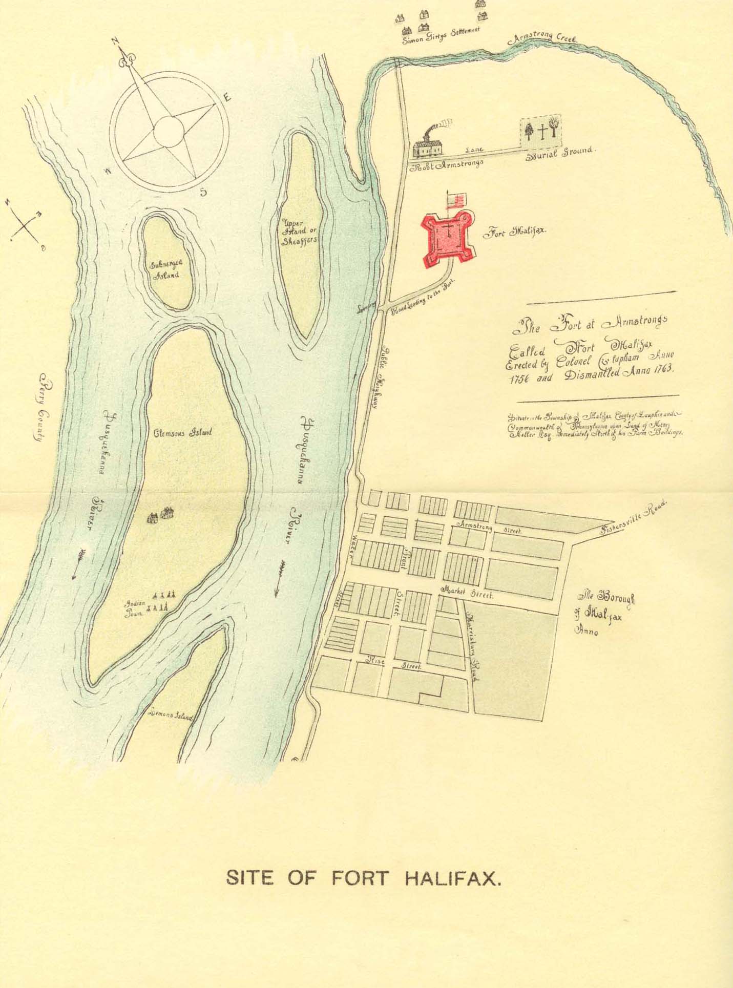
Site of Fort Halifax. Plan of Fort Halifax.
This fort was classed among a line of fortifications erected at different periods between 1752 and 1763, by the Provincial government, between the rivers Delaware and Potomac. Fort Halifax was built at the mouth of Armstrong creek about half a mile above the present town of Halifax. There is nothing left now to mark the spot, except a slight elevation of the ground and a well known to have belonged to the fort. The fort was built in 1756 by Colonel William Clapham. The Colonel selected it as the most convenient place on the river between Harris and Shamokin for a magazine, on account of its good natural situation above the Juniata Falls. In addition to this there was plenty of pine timber on the ground and the nearness of this place to Shamokin, he therefore concluded to erect a fort at this place. According to plans furnished he had squared two hundred logs about thirty feet in length which he drew to the place in order that it could be built as quickly as possible, so the troops would not be delayed. After he had done all these things he undertook to finish it in two weeks. Under guard of an officer and thirty men, being satisfied with the progress that was made at the fort he proceeded on the march with these troops up the river in batteaux to McKee's store.
In a letter dated June 20th, Governor Morris states to Col. Clapham, "The progress already made in this fort renders it impracticable for me to comply with the Commissioner's desire to contract it at which I was surprised, as I expected every day orders to enlarge it, it being yet, in my opinion, too small. I shall leave an officer and thirty men with orders to finish it when I march from hence." In a postscript the Colonel adds, "The fort at this place without a name till your honor is pleased to confer one." Up to this time, this place was known as Camp Armstrong.
Philadelphia, June 25th, 1756, Governor Morris writes: "The Fort at Armstrong's, I would have it called Fort Halifax.
Immediately on receiving instructions, Col. Clapham proceeded to erect the Fort, as appears from the following: "After receiving a proclamation enjoining, a cessation of hostilities for a period of thirty days, and which proclamation was carried out by him, he claimed he was at a great loss to know how to proceed, not having any instructions as to whether his marching into the country may or may not be deemed an act of hostility. And in order to justify this action was compelled to leave it to the opinion of a council of war. He also complains "that the Fort at this place is not in a condition to be left, as the waters of the river are daily falling and the opportunity of carriage by water to Shamokin, might fail."
Col. Clapham was further ordered to proceed to Shamokin, now Sunbury, and previous to embarking for that post he wrote to Governor Morris, under date of July first, 1756, as follows: "I shall leave a sergeant's party at Harris , consisting of twelve men, twenty-four at Hunter's Fort, twenty-four at McKee's store, each in command of an ensign; and Capt. Miles with thirty men at Fort Halifax, with the endorsed instructions, as I have removed all the stores from Harris Ferry and McKee's to this place."
On the 1st of July, 1756, Col. Clapham writes from Fort Halifax: "You are to command a party of thirty men at Fort Halifax which you are to finish with all possible expedition, observing not to suffer your party to straggle in small numbers into the woods or to go any great distance from the fort, unless detached as an escort, or in case of special orders for that purpose. You are to build barracks within the fort for your men and also a store house thirty feet by twelve, in which you are carefully to lodge all provisions, stores, etc., belonging to the Province; if the boards purchased for that purpose are not sufficient to finish the banquette and execute the other designs herein recommended, your men are to be employed in sawing more out of the pine logs now lying near the fort. You are to keep a constant guard, and relieve regularly, to have continual one sentry in each bastion and in case of an attack to retreat to the fort and defend it to the last extremity. If anything extraordinary occurs, you are immediately to dispatch notice thereof to his honor, the Governor, and to signify the same to me, if any relief or instructions may be necessary."
From the imperfect historical data at hand it appears as though Fort Hunter was subsequently abandoned and the garrison removed to Fort Halifax. In August, 1757, in a petition to the Provincial Council, the inhabitants of Paxtang set forth "that the evacuation of Fort Hunter is of great disadvantage to them; that Fort Halifax is not necessary to secure communication with Fort Augusta and is not so proper a station for the batteaux parties as Fort Hunter; pray the Governor would be pleased to fix a sufficient number of men at Hunter's, under the command of an active officer, with strict orders to range the frontiers daily." This petition was backed up by personal letters to the officers of the Council, among which was the following from the Rev. John Elder: "Paxton, July 30th, 1757. As we of this township have petitioned the Governor for the removal of the garrison from Halifax to Hunter's, I beg the favor of you to use your interest with his Honor in our behalf. The defence of Halifax is of no advantage; but a garrison at Hunter's under the command of an active officer, will be of great service; it will render the carriage of provisions and ammunition for the use of Augusta, more easy and less expensive; and by encouraging the inhabitants to continue in their places, will prevent the weakening of the frontier settlements. We have only hinted at these things in the petition, which you will please to enlarge on, in the conversation with the Governor, and urge in such a manner as you think proper. ‘Tis well known that representatives from the back inhabitants have but little weight with the gentlemen in power, looking on us either as incapable of forming just notions of things, or as biased with selfish views. However, I am satisfied that you, Sir, have more favorable conception of us; and that from the, knowledge you have of the situation of the places mentioned in our petition, you will readily agree with us and use your best offices with the Governor to prevail with him to grant it; and you will very much oblige, Sir, your most obedient and humble Servant, John Elder."
Pending the consideration of this question in Council, Commissary Young was called before that body. He stated that Fort Halifax is a very bad situation, being built between two ranges of hills, and nobody living near it, none could be protected by it; that it is no station for batteaux parties, having no command of the channel, which runs close on the western shore, and is besides covered with a large island between the channel and fort, so that numbers of the enemy may even in daytime run down the river without being seen by that garrison.
These petitions for assistance from the neighborhood of Fort Hunter were inspired by the fact that the Indians made several invasions there in 1757 and one man was killed within twenty rods of Hunter's barn. While the Provincial Council was not convinced of the advisability of abandoning Fort Halifax at that time, it was satisfied of the inadequacy of the force at Fort Hunter. Just when re-inforcements were ordered there does not appear, but when Col. Burd visited the fort in 1758, the garrison consisted of Captains Patterson and Levis and eighty men. They were, however, so poorly provided with powder and lead as to be practically useless, the Captain testifying that there were not on hand three rounds to a man. Fort Halifax was dismantled and abandoned in 1763, and, as previously stated, nothing now remains to mark its location but a slight elevation of the ground and the old well which was inside the circular bastion.
If the purpose of its construction was, as some of the correspondents would lead us to believe, the protection of the batteaux which then carried stores, provisions and passengers to Forts McKee and Augusta, the site was ill chosen, because, as claimed in the petition to the Council for its abandonment, the channel was on the opposite side of the river, and between it and the fort were two islands which would have effectually hidden the passage up the river, either by day or night of armed enemies.
One of these islands is that owned by John Clemson, while the other is now but a ledge of rocks. There was little use for the fort as a protection for the settlers in the immediate vicinity as there were practically none north of Peter's mountain at that time.
John Meetch is said to have located upon the land now owned by one of his descendants, William B. Meetch, in Halifax township, some time in 1752, and is claimed to have been the pioneer in this section of the county. Some member of the Armstrong family must either have been here then or came shortly after, as Governor Morris in his letter to Col. Clapham, dated June 21st, 1756, in relation to the name of the fort said: "The Fort at Armstrong I would have it called Fort Halifax." From this it is evident that there was then in the vicinity some settler by the name of Armstrong from whom the fort took its temporary name. And what is more conclusive, a Moravian missionary, passing through in 1746 reported Armstrong as being here then and the only white man in the vicinity. It is probable, therefore, that Armstrong was the first settler and at the time the fort was constructed his family and that of John Meetch were the only white persons in the neighborhood. It would, consequently, seem rather strange that the Provincial government should incur the expense of erecting a fort for the protection of such a handful of people. It is more than likely however, that the primary object of the fort was to afford a safe shelter for the wagon trains which made the journey from Fort Hunter to Fort Augusta in two days. This fact is borne out also by letters written between the Provincial authorities and Col. Clapham that it was to be a place used more particularly as a base of supplies for those forts north or up the river.
Travelers and wagon trains passing here spent the intervening nights at the fort, in going up and down the river between Fort Hunter and Fort Augusta. Such protection was essentially necessary at that time, because the large island now owned by Albert Clemson was the home of a considerable number of Indians who would have exterminated the trains had there not been some safe place for them to pass the night. At or near this historic place, lived Simon Girty the outlaw's father of the same name, an Indian trader. After he was driven out of Shearman's Creek settlement he removed with his family near where the town of Halifax is situated, subsequently removing westward.
The fort was a quadrangle with four bastions and was an earthwork about ten feet high, surrounded by a ditch of equal depth. The land on which it was located is now owned by Henry A. Kelker, Esq., of Harrisburg.
______
FRANKLIN COUNTY.
Map of Site of Forts in Lower Cumberland Valley.
FORT CHAMBERS.
Pages 527-533.This fort was erected by Benjamin Chambers in the year 1756 in the Conococheague settlement. Its site was at the confluence of Falling Spring and the Conococheague creek, where now the town of Chambersburg stands. It was considered the most defensive and safe fort in the Conecocheague settlement. A more specific location of the fort was furnished the writer as follows: Fort Chambers was on the bank of the Conococheague creek where the Falling Spring enters, the stockade enclosing the mouth of the spring. It stood just west of North Main street and midway between Market and King streets, in the borough of Chambersburg. Most of the ground upon which this fort stood is covered by the Chambersburg woolen mill, now owned by P. K. Appenzellar, of this place. And part of it, covered by the town mill, owned by a Mr. Reigner.
The founder of this fort, Benjamin Chambers, with three other brothers, emigrated from the county of Antrim, in Ireland, to the province of Pennsylvania, between the years 1726 and 1730. They first settled at the mouth of Fishing creek, in Dauphin county, on the Susquehanna river, and built a mill. After remaining there some time, they were encouraged by the proprietary officers and agents to make settlements west of that river. Although the lands were not purchased from the Indians until October, 1736, yet the agents and proprietors knowing the feelings of the Indians to be favorable, encouraged the settlers to come hither and issued to them special licenses for the settlement and securing of such tracts of land, beyond the Susquehanna, as might please their fancy. It is stated that Benjamin Chambers, the founder of this fort, was probably the first white man who made a settlement in what is now known as the county of Franklin. And here it was that he began his operations at the confluence of Falling spring and Conococheague creek. He improved his location by the erection of a hewed log house, which he covered with lapped shingles, fastened by nails, a style of building out of the common mode of round logs and clapboard roofs secured by beams. Some time after, Mr. Chambers leaving his house unoccupied for a short time, on his return found it burned to ashes. This was afterwards ascertained to be the work of an unprincipled hunter, who was induced to do it for the sake of the nails, which at that early day, in this wild region, were esteemed no ordinary prize. This may or may not be true. When Benjamin Chambers located here he was attracted to this spot by the vivid description of a hunter who was familiar with that section of country, and related to him the benefits of a fine water power, such as he had seen in that territory. Being somewhat of an artisan, in the art of mill-work, he took advantage of this information. After his house had been burned by the hunter vandal, he prosecuted anew his improvements, building houses, clearing lands, and soon after the commission from the proprietary government to Thos. Blunston allowing licenses for the settlement of lands west of the Susquehanna, Benjamin Chambers was granted a license, to take and settle and improve four hundred acres of land at the Falling spring mouth, on both sides of the Conococheague creek, for the convenience of a mill and plantation.
This license was granted specially, in order to fill up the valley as speedily as possible with settlers, and also south, and thus be the means of crowding out and preventing encroachments made by newcomers under Maryland rights, chiefly on account of the disputes and long delay in determining the boundaries between the two provinces. Mr. Chambers, however, did not obtain a patent for his land until the fourteenth of March, 1764, and it then contained five hundred and twenty-three acres. For a long time, he maintained a friendly intercourse with the Indians, who became attached to him. He traded with them, and had so much of their confidence and good will, that they did not offer to injure him or molest him. He also exerted a great effort among his acquaintances to induce them to settle in his neighborhood, directing their attention to desirable and advantageous situations for farms. He was also commissioned a justice of the peace and made a colonel of the militia under the provincial government, at an early period. As an arbitrator, he was just and equitable, and called in to settle many controversies between his neighbors, and whose judgment was always sought after by the early settlers, with whom he exerted a powerful influence.As the western Indians, after the defeat of Braddock, in 1755, became troublesome and made incursions into the valley, killing and making prisoners many of the settlers, Colonel Chambers, for the security of his family and his neighbors, erected a large stone dwelling house, surrounded by the water of Falling spring, and situate where the paper mill now is.
In order to make the house more secure against the attacks of the Indians, it was roofed with lead. The dwelling and the mill were surrounded by a stockade. This fort, with firearms, blunderbuss, and swivel, was so formidable to the Indians that they seldom assailed it, while those who ventured out were either killed or carried off as prisoners. As the records show, at a meeting of the general committee, of Cumberland county, convened by order of John Potter, sheriff of the county at the house of Mr. Shippen, October 30, 1755, at which eighteen persons were present, it was resolved to immediately build five large forts, namely: "Carlisle, Shippensburg, Col. Chambers', Mr. Steele's Meeting House, and one at William Allison's Esquire, in which the women and children were to be deposited," from which an alarm or intelligence was to be sent to the other forts.
Mr. Chambers was one of those present at this meeting, but it does not appear, from any information obtained, that this plan was executed, at least so far as relates to this fort. (Shippen papers, No. 35.) It is therefore believed that this was a private fort, erected by Mr. Chambers, in 1756, which was visited by James Young, who, October 17th,, speaks of it thus:
"In our journey to Fort Lyttleton we stopped at Mr. Chambers' Mill, ten miles beyond Shippensburg, towards McDowell's where he has a good private fort, and on an exceeding good situation to be made very defensible, but what I think of great consequence to the government is that in said fort are two four pound cannon mounted, and nobody but a few country people to defend it. If the enemy should take that fort, they would naturally bring those cannon against Shippensburg and Carlisle. I, therefore, presume to recommend it to your Honor, either to have the cannon taken from thence, or a proper garrison stationed there."
Acting probably on this suggestion, the Governor wrote respecting them, to Lieutenant Colonel John Armstrong, who in reply, November 30, 1756, says:
"I have wrote to Mr. Chambers concerning the guns at his Fort, according to order, but he thinks by going to Philadelphia, he may prevail with your Honor to let them stay where they are."
In the year 1756, he got into trouble with the Provincial authorities about"His great guns." They were fearful that the French and Indians might capture Mr. Chambers' fort and turn these guns toward other places. Lieutenant William Denny demanded these guns of Colonel Chambers in 1757, and commissioned the sheriff of Cumberland county to seize them. Colonel Chambers resisted the demand, and his neighbors sustained him in his refusal to give them up. The people throughout this whole valley were greatly excited at what they conceived the unjust demand of the government. Colonel John Armstrong, writing about Mr. Chambers' conduct says: "It is thought he designs to give trouble as he has the brass and malice of the devil."
Colonel Chambers held on to his guns, and having given bond to try his rights in court, the Government quietly dropped the matter. This had a tendency among all the justices of the peace of Cumberland county to cause them to resign their commissions, and Colonel Armstrong says, there was much difficulty in filling their places, on account of the "Governor's treatment of Benjamin Chambers in regard to his guns."
The writer here inserts what is reported to have been the final result in a letter from Colonel Armstrong, June 30th, 1757: That despite his recognizance to appear before the Governor, who issued the writ, the cannon seemed to be still in his possession, and it was suggested that the Governor should write to Colonel Stanwix, who may think it necessary to seize the guns himself. It is intimated that a suit was intended by Colonel Chambers, and that the Governor's treatment of him may have caused some difficulty in the appointment of magistrates.
From volume twelve, first series of Pennsylvania Archives, we give a letter by George Chambers, dated October 31st, 1855, in which he says: "The most defensive and safe fort in the Conecocheague country was that erected by Colonel Benjamin Chambers at the confluence of the Falling spring and the Conococheague creek, where the town of Chambersburg is located. It was erected in the winter and spring of 1756, being a stockade, including the dwelling house, flour and saw mills, of the proprietor. Within the fort, he erected a large stone building, two stories in height, the waters of the Falling spring running under part of it, for safe access to the water. Its windows were small and adapted to defence. The roof of it was covered with sheet lead to protect it against fire from the savages. In addition to small arms, Colonel Chambers had supplied himself with two four-pound cannon, which were mounted and used.
"Within the fort he remained in safety with his family throughout the whole series of Indian wars. It was also a place of shelter and security to many of the neighboring families in times of alarm. Though the fort was assailed sometimes by the Indians, no one was injured that remained within its enclosure. The name and reports of the cannon made the enemy cautious how they approached the fort, and kept them from it a considerable distance."
A man by the name of McKinney, who had sought shelter with his family in the fort about 1756, ventured out in company with his son, to visit his dwelling and plantation, where the paper mill now stands along the creek. They were discovered, however, by the Indians and both killed and scalped, and their dead bodies brought to the fort and buried.
Colonel Chambers was active in organizing the militia, and was of a great deal of assistance to General Forbes in giving him information and aiding him in the opening of a road as well as affording him supplies in his march through the valley and across the mountain in his campaign. He saw that the flour mills were of such accommodation in the Conococheague settlement, that they achieved a great notoriety, far and wide, and were known as "The Mills." Colonel Chambers, at a very early period appropriated as a burial ground a beautiful and romantic cedar grove adjoining the Falling Spring church. The spot is yet one of the most appropriate places of sepulture to be found in the Cumberland valley. He made this conveyance, in 1768, with additional grounds, in trust for the Presbyterian congregation of the Falling Spring church, of which he was an active and efficient member.
At the commencement of the Revolutionary struggle, being aged and infirm, and yet an ardent patriot, in full sympathy with his struggling countrymen, he sent three of his Sons. James, William and Benjamin, to the army at Boston, to do what he could not, namely, to fight for the independence of their native land. As Mr. McCauley remarks, Colonel Chambers lived to see the country of his adoption, one of the free and independent nations of the earth, beginning her career with every prospect for national prosperity and greatness— when, on the 17th of February, 1788, he closed his long, busy and eventful life and was buried in the cemetery his munificence had set apart for the use of his neighbors and those of his religious faith on the banks of the clear and beautiful Conococheague.
The lineal descendants of this brave and magnanimous man are living on the very spot where this fort was first erected. They are to-day, as were their hardy and patriot progenitors, haters of oppression and lovers of liberty. They like their fathers of old, help to bear the heavy burdens of society and play a prominent part in the further development and promotion of this latter day enterprise which is making our country and our State among the foremost in the civilized world.
______
FORT DAVIS.
Page 533-534.This fort was erected by Philip Davis in 1756, being about nine miles south of Fort Loudoun, near the Maryland boundary line, and at the northern termination of one of the Kittatinny ranges, and which in early times, and since has been known as Davis' Knob. The fort was occasionally garrisoned by companies of rangers, who passed between the fort. By information furnished the writer by Doctor H. G Chritzman, of Welsh Run, Franklin county, Pennsylvania this fort seems to have been located on a slight knoll, known as Casey's Knob, overlooking a spring, on the McPherran farm, now owned by Royer's heirs, being two miles southwest of Welsh Run, this county.
In Rupp's History of Franklin county, reference is made to a paper which was found among some documents in the Secretary's office at Harrisburg, the paper being without date. It is headed "A Plan for the Defence of the Frontier of Cumberland County, from Philip Davis to Shippensburg: Let one company cover from Philip Davis to Thomas Waddell's and as John McDowell's Mill is at the most important path, most exposed to danger, has a Fort already made about it, and their provisions may be most easily had for these reasons, let the chief quarters be there. Let five men be constantly at Philip Davis', William Marshall's and Thomas Waddell's and ten return from thence in the evening. Likewise ten men sent from the chief quarters to the utter extremity, daily, to go by William Marshall's to Philip Davis' and returning the same way in the afternoon.
"By this plan the whole bounds will be patrolled twice every day, a watch will be constantly kept at four most important places, and there will be every night forty-five men at the chief quarters, ready for any exigency. Another company may cover as much more of the frontier, beginning where the first ends and reach towards and back of Shippensburg, by fixing a chief quarter in some convenient place, about the middle of said bounds, and thence patrolling the ground twice a day, and keeping watches at the most proper places as above, one of which watches may be constantly at Mr. Armstrong's and another at a proper place at the other extremity.
"This plan supposes each of the companies to consist of sixty men in all, as fewer cannot so patrol, keep watch and have any force together to answer such exigency as may occur. These may be furnished by deducting seventeen out of each of the four forts, back of our frontier, this leaves sixty in each fort, and makes up a new company of sixty men, and eight to be added to Captain Potter's company."
Doctor Egle says: "This fort was sixty-three miles from Harris Ferry, according to the only notice in the archives, volume two, pp. 134. From B. Chambers', sixteen and one half miles and twenty miles from Shippensburg. Its situation can be seen as laid down on the lithographic plan of 1764."
The writer can gain no information as to the founder of this fort, his acts and deeds. The information directly concerning this location, was furnished by Rachel Davis, of the state of Indiana, who is a direct descendant of Philip Davis.
______
FORT LOUDOUN.
Pages 534-542.This fort was located about one mile distant from the present town of Loudon, Franklin county, Pennsylvania. It was erected by Colonel Armstrong, in the year 1756, and was situated about two miles southwest of Parnell's Knob, on the east side of the West branch of the Conococheague creek, where Nathan Patton lived. The village of Loudon is situate about one mile west of the old fort. The ground upon which this fort was located is a farm that originally belonged to the Stenger family; but now owned by Mr. Hoerner, of Loudon. It is thirteen miles west of Chambersburg and one mile from the turnpike road. There are still some faint indications outside of the yard, showing where it was erected. The writer, on a visit to this spot, was shown the foundation and the chimney walls of an outbuilding, erected on Mr. Hoerner's premises, and was informed that many of the stones and the logs constituting this building, were taken from the remains of this fort, and are still to be seen, to this day. The first intention, when this fort was about to be erected, was to place it at Barr's, which was near McDowell's mill, but by subsequent reports Barr's place was abandoned, because the soil was considered too strong and heavy, and, therefore, the site was cast near to Parnell's Knob as we have stated before, Mr. Patton lived.
The settlement in which this fort was located, was among the first in that section of the country, and many were the stirring scenes enacted there in the old colonial times. This fort was erected by the Provincial government for the protection of the frontier settlers against the incursions of the Indians. It was frequently garrisoned by British as well as Provincial troops. Before the wagon roads were built over the mountains, it was a great point of departure for pack horse trains, for Bedford, Fort Cumberland and Pittsburgh. All transportation was done by pack horses, each carrying a burden of about two hundred pounds. Sir John Sinclair, quartermaster general of General Braddock, moved much of his supplies by that route, and had one of his principal magazines at McDowell's fort. After Braddock's defeat, a large part of his dispirited and destitute troops returned by that route and were quartered at Shippensburg and Carlisle. In 1755, the Province of Pennsylvania made a broad wagon road from Fort Loudoun westward, which General Forbes and Colonel Bouquet and others used in their western expeditions. Upon that road, for the greater part of its length, the present Chambersburg and Pittsburgh turnpike was built.
It was at this fort that many prominent military characters of the day rendezvoused, and numerous were the incidents that transpired in its vicinity, of which, however, very little has been preserved, excepting in a doubtful, uncertain and conflicting tradition. The earlier records subsequently printed seem to be somewhat at variance. Passing by much of this tradition, this fort appears to have been commenced under the direction of Colonel John Armstrong in the autumn of 1756. As stated heretofore, it was intended at first to place it at Barr's, which was near to McDowell's mill, and to have commenced it early in November of that year, "but was then prevented by having to escort some cattle to Fort Lyttleton." By another letter dated November 19th, Col. Armstrong appears to have selected another place after examination at Barr's, and says he "Could not find in it a proper situation for a fort, the soil being too strong to admit the ditch, and the spot itself overlooked by an adjoining hill, but have fixed on a place in that neighborhood, near to Parnell's Knob, where one Patton lives;" * * "as it is near the new road, it will make the distance from Shippensburg to Fort Lyttleton two miles further than by McDowell's. I am making the best preparation in my power to forward this new fort as well as to prepare the barracks, etc., all the others, for the approaching winter."
On December 22, 1756, Mr. Stevens says, "The public stores are safely removed from McDowell's mill to Fort Loudoun— the barracks for the soldiers are built and some proficiency made in the stockade, the finishing of which will doubtless be retarded by the inclemency of the weather. Yesterday the escort of one hundred men returned from Lyttleton, who left the cattle, etc., safe there, and today will begin to dig a cellar in the new fort. The logs and roof of a new house having there been erected by Patton before the Indians burned his old one; we shall first appraise this house and then take the benefit of it, either for officer's barracks or a store house or provisions."
At this time the fort had not received a name, and Colonel Armstrong asked if it may be called "Pomfret Castle," from which it appears that he did not know that another fort was already so called. It is probable, therefore, that he was directed to name it "Fort Loudoun," after Lord Loudoun, who arrived July 23d previously, as general and commander-in-chief of all His Majesty's forces in North America. The situation of this fort may be seen on the plan of 1764. "It was about two miles southwest of Parnell's Knob, a termination of one of the Kittatinny range of mountains, and about five miles east of the Cove or Tuscarora mountain, on the west branch of the Conococheague creek. The town of Loudon, in Franklin county, a small village, on the west, about a mile distant, was named after the old fort, but unfortunately the proper orthography is not preserved. It extended over something more than an acre of ground, the foundations being of stone, are still visible—the fort erected above being of logs, which have disappeared. The foundations of chimneys of buildings occupied within the enclosure are still to be seen. During the Indian wars that followed Braddock's defeat, it was occupied by military companies of the Provincial and Royal regiments, for rendezvous, as well as for military stores and army supplies. In 1757 it was decided that only four forts over the Susquehanna were to remain—of these, Fort Loudoun was one, with a garrison of two companies of Colonel Armstrong's battalion, to be employed in patrolling between these forts.Captain Croghan, in June, 1757, received a long letter from Mr. Atkin, informing him that, thirty-three Cherokees had stolen away from the southern district, towards Pennsylvania. Another body of Indians arrived with presents to be distributed. They were much out of tune at hearing of Colonel Washington's putting some of their brethren in prison at Winchester, the cause of which being unknown, Mr. Smith and a guard were sent to Colonel Washington to ascertain the reason—who are to meet them at this fort—they profess to be part of a powerful band who could furnish five hundred warriors. Provisions were very scarce and twelve men went down with the "Flux." Colonel Stanwix orders provisions to be purchased.
General Forbes, on his way to Fort Duquesne to expel the French and their savage allies from the frontiers, while here, addressed a letter to Governor Denny, urging the importance of a hearty co-operation of the Governor and the people of the Province of Pennsylvania to ensure success against the enemy. On the ninth of September, 1758, he wrote the Governor: "Everything is in readiness for the army's advancing, but that I cannot do unless I have a sufficient quantity of provisions in the magazine at Raystown." In October, 1758, General Forbes recommends to the Governor, the absolute necessity of distributing twelve hundred men among the different forts, one hundred of whom were to be stationed at Fort Loudoun. He had previously been here on his way to Raystown.Captain Samuel Miles, in his "Journal," says: "In the year 1758, the expedition against Fort Duquesne was undertaken and our battalion joined the British army at Carlisle. At this time Captain Lloyd had been promoted to the rank of Lieutenant Colonel, but retained his company, of which I had the command as captain-lieutenant, and was left some time in command of the garrison at Shippensburg. On my marching from thence with a brigade of wagons under my charge, at Chambers about eleven miles from Shippensburg, the men mutinied and were preparing to march, but my reasoning with them and at the same time my threatening them, the most of them consented to resume their march to Fort Loudoun, where Lieutenant Scott was with eight or ten months pay. While the army lay at Ligonier we were attacked by a body of French and Indians, and I was wounded on the foot by a spent ball.
In November of this year, the army took possession of Fort Duquesne under the command of General Forbes, a poor, emaciated old man, who, for the most part of the march, was obliged to be carried in a horse litter. At about this time, Fort Duquesne was evacuated by the French, and in June, 1764, Colonel John Armstrong advises Governor Penn, from Carlisle, that by advices received from a Captain Murray, of the Royal Highlanders, on the morning of the 5th, thirteen persons were killed and several houses burned to the ground about four miles south of Fort Loudoun by the Indians, whose number was not then ascertained.
"At this time a number of the traders suffered at the hands of certain persons who sought to kill them, or at least alarm them in order to get their goods. The traders went back to Fort Loudoun and applied to the commanding officer there and got a party of Highland soldiers and went with them in quest of the robbers, as they were called, and without applying to a magistrate, or obtaining any civil authority, but barely upon suspicion, they took a number of creditable persons prisoners, and confined them in the guard house at Fort Loudoun. It was then that three hundred riflemen marched to Fort Loudoun and encamped on the hill in sight of the fort. They were not long there, until they had more than double as many of the British troops prisoners in camp as they had of our people in the guard house. Captain Grant, a Highland officer, who commanded Fort Loudoun, then sent a flag of truce to our camp, where we settled a cartel and gave them above two for one, which enabled us to redeem all our men from the guard house, without further difficulty. After this, Captain Grant kept a number of rifle guns, which the Highlanders had taken from the country people and refused to give them up. As he was riding out one day, he was taken prisoner and detained until he delivered up the arms. He also destroyed a large quantity of gunpowder that the traders had stored up, lest it might be conveyed to the Indians. The King's troops and our party had now got entirely out of the channel of the civil law and many unjustifiable things were resorted to by both parties."
The following letter, dated at Carlisle, June 1, 1765, contains much of interest and spirit of the ‘times:
"I received letters from Lieutenant Grant, commanding at Fort Loudoun, complaining much of some late insult, received from the rioters near that post. He says on the 28th ult., (May), he was taking the air on horseback and about half a mile from his post, was surrounded by five of the rioters, who presented their pieces at him. The person who commanded them, calling to them to "shoot the bugger"—that one of them fired at him, frightened him and his horse that he ran into the bushes and occasioned his being thrown upon the ground. They then disarmed him, carried him fifteen miles into the woods and threatened to tie him to a tree and let him perish if he would not give them up some arms which by his orders were taken from the first party of the rioters that had appeared at his post. When he saw they were determined to put their threats into execution, he thought it was best to promise them their arms and was made to give security to deliver them up in five weeks under a penalty of forty pounds, which being obtained in that manner, certainly cannot be binding."
Another letter from Fort Loudoun, of the 4th of June, 1765,
"The first rendezvous of the rioters was at Justice Smiths, about five miles from Fort Loudoun, the sixth day of March last. From thence they followed the first convoy of goods, consisting of eighty-one horse loads, twelve miles further and burned and pillaged sixty-three loads. Captain Callender applied to Lieutenant Grant for a sergeant and twelve men, which he agreed to, who saved the remaining loads, chiefly consisting of liquors, and made some of the rioters prisoners, who were afterwards released upon bail, and took eight rifles, in all which Lieutenant Grant is justified by Brig. Bouquet, in his letter of the 14th of March, who desired him to keep the rifles in his possession, till the owner's name shall be found out, which was accordingly done."
To come back to a narrative as detailed by Captain James Smith in his adventures, we deem it of interest to insert the same: "In the year 1763, after peace had been restored, new hostilities were again commenced by the Indians and were busily carried on by them, they being engaged in killing and scalping the inhabitants of various parts on the Pennsylvania frontiers. The whole Conococheague valley, from the North to the South mountain, had been almost entirely evacuated during Braddock's war. This state was then a Quaker government, and at the first of this war the frontiers received no assistance from the state.
"As the people were now beginning to live at home again, they thought it very hard to be driven away a second time, and hence were determined to make a stand, if possible, against the enemy. They raised some money by collections and subscriptions, in order to pay a company of riflemen for a stated period. The subscribers organized a committee to manage the business, and James Smith was made their Captain. He had the power to choose his own subalterns and selected from their number two active young men, who had been long in captivity with the Indians. The men were ordered to be dressed in Indian fashion, and as nearly as the Highlanders wear their plaids. They wore red handkerchiefs instead of hats, and painted their faces red and black like Indian warriors. They were taught the Indian discipline, as that was considered better to meet all the emergencies of the British. They succeeded beyond expectation in defending the frontiers, much to the praise of those higher in authority, from which he received a commission in the regular service under King George.
"In the following year he went out on General Bouquet's campaign against the Indians on the Muskingum and brought them to terms and promised to be at peace with them, upon condition that they would give up all our people that they then had among them. They, accordingly handed over three hundred such prisoners and said they could not collect them all at that time, as they were scattered far and near; but promised to bring them to Fort Pitt the following spring and entered into security for the faithful fulfillment of that negotiation.
"About March 1st, 1765, a number of wagons loaded with Indian goods were sent from Philadelphia to Henry Collins, Conococheague, and from thence seventy pack horses loaded with these goods to carry into Fort Pitt. This alarmed the country, and Mr. William Duffield raised about fifty armed men and met the pack horses near Fort Loudoun. Mr. Duffield desired the store of goods to be stored up until further orders, but this was not obeyed, and they proceeded on their journey, notwithstanding, the great danger of the Indians attacking them and destroying the party. They were fired upon by the rear by the savages at a point in the march, their goods taken and burned. The traders went back to Fort Loudoun, applied to the commanding officer for aid and it was then that three hundred riflemen marched to Fort Loudoun and encamped on the hill in sight of the fort, heretofore referred to."
We thus see by the foregoing data relative to Fort Loudoun, that it was an important post on the frontier at a period when the red man held almost undisputed sway in the now far-famed Cumberland and Shenandoah valleys, rich and teeming under the guiding hand of the faithful husbandman, in these latter days; that its location on the great commercial highway to the West, leading to Forts Pitt and Bedford, gave it a pre-eminence in the catalogue of early frontier defenses, rendering it worthy now of receiving the State mark as suggested in the act of Assembly and that its importance as a military, trading and rendezvousing post cannot be overestimated.
______
FORT McCORD.
Page 542-545.This was a private fort erected in 1756, along the base of the Kittatinny mountain, north of Parnell's Knob. It was occupied temporarily during the early Indian wars. By an inspection of this site, the writer locates this fort a few miles northwest of Loudoun, near Bossert's Mills, and is now upon the land owned by ‘Squire Bossert. The site of this fort was three or four rods east from the public road, leading from Strasburg to St. Thomas, seven miles from the former place and six miles from the latter. It is six rods due south of the location of Mr. Bossert's barn. This is one of the oldest forts in this county, in Hamilton township. It was erected as a place of defence for the settlers. Mr. Bossert remembers having heard detailed information, that a few white persons and Indians were buried near this fort in a grave yard, fenced off from a side of the garden, belonging to the residence in which he lived. The fort was torn down by Mr. Bossert's grandfather. It was constructed of heavy timber and it was dug deeply into the ground which surrounded it.
There was a severe engagement had at this fort, in which it was captured by the Indians on or about the fourth day of April, 1756, and burned, and all the inmates, twenty-seven in number, were either killed or carried into captivity. This circumstance very much impaired the confidence the settlers had in private forts, and it is presumed no doubt lead to the erection of forts of greater security. At the time of the capture of this fort, Doctor Jamison, of Colonel Armstrong's battalion, was killed by the Indians near McCord's Fort; and at about the same time persons employed by William Mitchell to harvest his crops were all killed or captured in the fields when at work.
This fort in the Conococheague was burned by the Indians according to Rupp's Cumberland County, etc., pp. 104, etc., and twenty-seven persons were killed or captured. The Indians escaped the pursuit of two parties of inhabitants of the vicinity, who had divided themselves into three parties to seek them. Several other forts along the frontier line were watched by outlying parties of savages, and every straggler was made a prisoner or shot down. The third party came up with the enemy at Sideling Hill, with whom they had a smart engagement for two hours during which they fired twenty-four rounds, but were overpowered by numbers, the Indians having been relieved by an additional force under Shingas. Each side sustained a loss of about twenty killed and as many wounded. This engagement was led under the command of Captain Culbertson. In a letter from Hance Hamilton to Captain Potter, dated Fort Lyttleton, April 4th, 1756, 8 o'clock P. M., he says:
"These come to inform you of the melancholy news of what occurred between the Indians, that have taken many captives from McCord's Fort and a party of men under the command of Captain Alexander Culbertson and nineteen of our men, the whole amounting to about fifty, with the captives, and and a sore engagement, many of both parties killed and many wounded, the number unknown. Those wounded want a surgeon, and those killed require your assistance as soon as possible, to bury them. We have sent an express to Fort Shirley for Doctor Mercer, supposing Doctor Jamison is killed or mortally wounded in the expedition. He being not returned, therefore, desire you will send an express, immediately, for Doctor Prentice to Carlisle, we imagining Doctor Mercer cannot leave the fort under the circumstances the fort is under."
From the narrative of Richard Bard, a native of Franklin county, Pennsylvania, who was taken captive by the Indians on the 13th of April, 1758, we have the following referring to McCord's Fort:
"Having secured the prisoners, they took all the valuable effects out of the house and set fire to the mill. They then proceeded towards the mountain and my mother enquiring of the Indians who had care of her, was informed that they were of the Delaware nation. At the distance of about seventy rods from the house, contrary to all their promises, they put to death Thomas Potter, and having proceeded on the mountain about three or four miles, one of the Indians sunk the spear of his tomahawk into the breast of the small child, and after repeated blows, scalped it. After crossing the mountain (evidently the Kittatinny) they passed the house of Mr. Halbert T____, and seeing him out, shot at him but without effect. Thence, passing late in the evening McCord's old fort, they encamped about half a mile in the gap. The second day, having passed into the Path Valley, they discovered a party of white men in pursuit of them, on which they ordered the prisoners to hasten, for should the whites come up with them they would all be tomahawked. Having been thus hurried, they reached the top of the Tuscarora mountain and all had set down to rest, when an Indian without any previous warning, sunk a tomahawk into the forehead of Samuel Hunter, who was seated by my father, and by repeated blows put an end to his existence." * * * * *
We have also a slight reference to Fort McCord in this connection, though two years anterior in time to the occurrence of the event above narrated, in which Robert Robinson, of the famous Robinson brothers of the Juniata and Tuscarora settlements says:
"In the year 1756 a party of Indians came out of the Conococheague to a garrison named McCord's Fort, where they killed some and took a number prisoners. They then took their course near to Fort Lyttleton. Captain Hamilton being stationed there with a company, hearing of their route at McCord's Fort, marched with his company of men, having an Indian with him who was under pay. The Indians had McCord's wife with them; they cut off Mr. James Blair's head and threw it into Mrs. McCord's lap, saying that it was her husband's head; but she knew it to be Blair's."
There are succeeding references in this same "Narrative," to transactions in and about Fort McCord, but the writer deems it unimportant to add them hereto, as the facts given sufficiently well establish the location. We might add that this fort, of course, had its prominence in the early troubles between the settlers and the Indians, being situate along the base of North Mountain, where the marauding bands of Indians were constantly on the alert for occasions to plunder and destroy life and property. The writer has no data at hand, whereby he is able to establish the fact that this fort was ever rebuilt; or that it ever thereafter figured in the subsequent history of the Province.
______
FORT McDOWELL.
Pages 545-549.The Historical Map of Pennsylvania places this fort midway, in a straight line, between Reverend Steel's Fort on the south and Fort Loudoun on the north, in Franklin county, Pennsylvania, east of the Kittatinny mountains, being in the western part of the county. It was built in the year 1756, at Bridgeport, Franklin county, where McDowell's mill stands. This fort was near the passes through the western mountains. It was about two miles south of Fort Loudoun, and upon the east bank of the west branch of the Conococheague creek. The writer received information from several of the older citizens in this locality that they had seen the old fort. It was built of logs, rectangular in shape, and had loop-holes in it. It stood until the year 1840. The property formerly was owned by James B. Scott. There is a store house erected on or near the site of this fort, which stands northeast of the store about ten feet. The present owner of the premises is William Branthaver.
This place seemed to be one of great notoriety and was referred to frequently by public officers and agents and was known as McDowell's Mill. From all accounts we can gather, this fort was a private establishment, and the earliest notice taken of it is in a letter from General Braddock, dated June 18th, 1755, signifying his approbation of the deposits being made at McDowell's Mill, instead of at Shippensburg.In July it is reported that the road cutters had returned as far as McDowell's Mill. These men were detached to construct a path through the forests and over the mountains for the English general and his army. On the 3d day of July, 1754, large numbers of the western Indians, says McCauley, in his History of Franklin county, acted with the British troops, in the capture of the Colonial forces, under Colonel George Washington at Fort Necessity, and they were mainly instrumental in causing the defeat of General Braddock, in July, 1755, and for nine years thereafter the frontier settlements were ravaged and desolated by their incursions.
In November, 1755, they ravaged the Great Cove. Out of a population of ninety-three persons, forty-seven were killed or taken captive. A few days after the house of the widow Cox, near McDowell's Mill, in Peters township, was burned, and her two sons and a hired man were carried off. In February, 1756, two brothers, John and Richard Craig, were captured by nine Delaware Indians, about two miles from McDowell's mill. In the same month a party of Indians made an incursion into the same township. They were discovered by a Mr. Alexander near Thomas Barr's house. He fled and they pursued him to McDowell's Fort, thus, apparently, at this early date, recognizing McDowell's Mills as a fort. The next day an engagement took place between the Indians and a portion of Captain Croghan's company, and about twelve young men, in which one of the soldiers and several of the Indians were killed and Barr's son wounded. The same party of Indians attempted to surprise the fort, but failing in that, retreated, and shortly after killed a young Dutch boy coming from foddering his master's cattle. They burnt Mr. Barr's house, consuming their dead in it, and meeting five men coming from Mr. Hoopes' to McDowell's, they fired upon them, killing one and wounding another very severely. Everywhere along the frontier did the Indians commit the most horrible murders. Their implacable cruelty was stimulated by the promise of reward for scalps, on the part of the French, besides the promise of restoring them their lands."
The Pennsylvania Archives gives us the following information concerning the establishment of this fort:
Governor Morris writes to General Braddock, July 3d, 1755, that he has sent certain enumerated officers to Shippensburg, where "They will remain till I go up into the country, which will be on Tuesday next, and then I shall form the magazine at or near McDowell's Mill, and put some stockadoes around it, to protect the magazines and the people that will have the care of it. For without something of this kind, as we have no militia, and the Assembly will maintain no men, four or five Indians may destroy the magazine, whenever they please, as the inhabitants of that part of the province are very much scattered. I send you the plan of the fort or stockado, which I shall make by setting logs of about ten feet long in the ground, so as to enclose the storehouses. I think to place two swivel guns, in two of the opposite bastions, which will be sufficient to guard against any attacks of small arms."
On the 6th, he says to the General, "The panic that has taken possession of the people near the mountain, since the Indians have begun to scalp will make it next to impossible to carry the magazine farther back than Shippensburg. However, I shall judge better of that when I am upon the spot and fix it either at McDowell's Mill or Shippensburg, or at some place between them."
In a letter from Colonel Armstrong to Governor Morris, dated Carlisle, August 20th, 1756, he says: "Tomorrow, God willing, the men march from McDowell's for Fort Shirley, and this afternoon some part of my own company with the provisions here set out for Shearman's Valley, then to halt till the residue come up. * * * * * * The harvest season with the two attacks on Fort Granville, has left us bare of ammunition, that I shall be obliged to apply to the stores here for some quantity for the expedition. The Captains Hamilton and Mercer have broken open the part I sent to McDowell for Fort Shirley, and given them receipts as for the expedition, though I know it, for the particular defence of those two posts, nor will it be in my power to prevail with double the number of men, and a double quantity of ammunition to keep a fort, that would have done it before the taking of Fort Granville. * * * Forts Lyttleton, Shippensburg and Carlisle, the two last not finished, are the only forts now built, that will in my opinion, be serviceable to the public. McDowell's, or thereabouts, is a necessary post; but the present fort is not defensible."
On the 6th of November apprehensions existed that George Croghan, at Aughwick, was in distress, though Captain Burd with forty men had just left the Conococheague for his relief, and Adam Hoopes writes that: "We intend to join him to-morrow, at McDowell's Mill with all the force we can raise. On the same day and month, he writes: "Hance Hamilton is now at McDowell's Mill with upwards of two hundred men, and about two hundred from this county, in all about four hundred men." On Wednesday, February 11th, 1756, two lads were taken or killed at Widow Cox's, just under Parnell's Knob, and a lad who went from McDowell's Mill to see what fire it was, never returned, the horse coming back with the reins over his neck; they burned the house and shot down the cattle. There were also various parties of Indians discovered by their tracks.
The Rev. John Steel is instructed, March 25th: "You will receive a commission appointing you Captain of a Company in the pay of the Province, which is to be made up by drafts of thirteen men out of each of the companies, composed by James Burd, Hance Hamilton, James Patterson, and Hugh Mercer, Esquires, to whom I now send orders to make the drafts accordingly; also a commission appointing James Holliday your Lieutenant. You will, therefore, as soon as may be, after your arrival in Cumberland county, send an officer, with my orders to the several Captains, to whom they are directed, to receive from them the drafts, agreeable to my orders. When you have formed your Company you are to take post at McDowell's Mill upon the road to Ohio, which you are to make your headquarters and to detach patrolling parties, from time to time, to scour the woods in such manner as you shall judge most consistent with the safety of the inhabitants. You are to inform me from time to time what you do, and of everything material that happens upon that part of the frontier, and of the number and motion of any body of French or Indians that you shall receive intelligence of."
In November, 1756, Samuel Perry and his two sons, going from the fort to their plantation, were killed, scalped and covered over with leaves. A party sent from the fort to search for them, were shortly after attacked by about thirty Indians. Our people fought for some time, but four of them falling, the rest made off. Six of our people got into the fort. What became of the rest is not known." Two families were cut off and grain and houses burned in the coves. It is further stated that at this time one hundred men are at the Fort, guarding and escorting public provisions to Fort Lyttleton, and they were on their way there. Colonel Armstrong writes from Carlisle, "The public stores are safely removed from McDowell's Mill to Fort Loudoun, the barracks for the soldiers are built and some proficiency made in the stockado."
The locality in which this fort stood was the scene of bloodshed, murder and devastation. A number of soldiers were killed, and many persons carried off as prisoners. The settlers were alike reduced to the hardships which were incident to the locality and the times. Of the settlers who were killed hereabouts were Samuel Perry, Hugh Terrell, John Culbertson and John Woods and his mother-in-law and Elizabeth Archer. Of those missing were four children of John Archer and a boy named Samuel Meily.
The family whose name this fort bears were among the earliest settlers in the Cumberland Valley. They were of Scotch Irish descent, and held various positions of trust, and today there are descendants who own large tracts of land in the very vicinity which was so fruitful of savage attacks and bloodshed in the early days.
______
FORT STEEL.
Page 550-555.This fort was erected in the year 1755. Its site is on the south side of the east branch of the Conococheague creek, being about twenty miles north from Mason and Dixon's line, and a little to the west of in a straight line of where Hagerstown, Maryland, stands. It was known in frontier times as Rev. Steel's Fort. It was situate where what is called the Presbyterian White Church, about five miles south of Fort Loudoun, and about three miles east of Mercersburg. It was a place of notoriety during the Indian wars. It was erected shortly after Braddock's defeat and was referred to shortly afterwards in connection with the Indian invasion which occurred in November of that year.
With regard to the appellation, Rev. Steel's Fort, Judge Chambers, an influential citizen of the community, states: "The first fort I have any information of in the Conococheague settlement is this one; this settlement composed nearly the whole of the county of Franklin. This was at John Steel's meeting house, which was surrounded by a rude stockade fort in 1755. Upon a visit of the Indians to this settlement in November, 1755, the Reverend Steel, with others to the number of about one hundred went in quest of them, but with no success. The location of this site was in one of the oldest settlements in the Conococheague Valley, and indeed, we find that settlements began as early as the year 1736. The land was assumed to be taken from the Proprietary by those only who designed to settle upon it and the settlement soon became numerous. A few years later they formed themselves into a congregation and enjoyed supplies of preaching from that time. Subsequently to this period, the congregation became divided and different churches were erected, but so united were they in their tenets that one preacher usually supplied several congregations. It is from this fact that we find one of the churches, known as The White Church, called the Reverend John Steel's Church. It was in this church that he was installed as the pastor in 1754, and at the same time holding a charge in the east Conococheague. In the year following this, this settlement was very greatly disturbed by the interruption and forays of the Indians on account of the injurious defeat of General Braddock. This was continued for upwards of two years until the settlement was entirely broken up. But after quiet was restored, the people again returned to their desolated homes and adopted their old form of a congregation and engaged supplies from the Presbytery of Donegal."
We here append data relative to the character of the Reverend John Steel, and show that his services in his pastoral relations hereabouts at that early time, were equaled by intrepidity on the field of battle as well, for we find him engaging in the frontier defences with a vigor characteristic of the brave pioneer of that day. Though a man of peace and engaged in teaching the doctrine of his Divine Master, yet his heart burned within him on account of the sufferings inflicted upon his parishioners and neighbors, and he speedily organized a company of rangers for their defence, of which he was unanimously elected the captain and was commissioned by the Provincial government.
After General Braddock's defeat in 1755, the Indians again swept over the western and southwestern part of this county, murdering and plundering the settlers, and, as we have stated before, Mr. Steel's congregation was for a time almost broken up and dispersed. Frequent mention is made of Mr. Steel and his men in the history of those troublous times. In a letter of instructions to John Steel, in 1756, we have the following: "With these instructions, you will receive a commission appointing you Captain of a company in the pay of the Province, which is to be made up by drafts of thirteen men out of each of the companies, composed by James Burd, Hance Hamilton, James Patterson and Hugh Mercer, Esq., to whom I now send orders to make the draft accordingly, and also a commission appointing James Holliday, your lieutenant. You will, therefore, as soon as may be, after your arrival in Cumberland county, send an officer, with my orders to the several Captains, to receive from them drafts agreeable to my orders. When you have formed your company, you are to take post at McDowell's Mill, upon the road to the Ohio which you are to make your headquarters and to detach patrolling parties from time to time, to scour the woods, in such manner as you shall judge, most consistent with the safety of the inhabitants. In case any of the men you receive should be unfit for service, you are to pay and discharge them, and enlist others in their stead, taking care to observe the form of enlistment prescribed to Captain Potter, from whom you will receive copies of the papers necessary to guide you in this particular. You are to inform me from time to time what you do, and of everything material that happened upon that part of the frontier, and of the number and motions of any body of French or Indians that you shall receive intelligence of. You are to apply to Mr. Adam Hoopes for the Provincial allowance of provisions for the men under your command." Under an order to James Burd. "a draft of thirteen private men made out of his company were to be delivered to John Steel, who was appointed Captain of a company."
In another letter from Rev. John Steel to Governor Morris, dated April 11th, 1756, written from Peters township, Cumberland county, we have the following:
"May it please your Honour, upon my return to Cumberland county, I applied immediately to Captain Burd and Captain Patterson for the drafts of their companies, according to your Honour's instructions, but the time for which most of their men had been enlisted, being expired, they could not fulfill your Honour's orders. Most of the force had not received their full complement of guns, but were in a great measure supplied by the arms the young men had brought with them. Captain Patterson had received but thirty-three fire arms, Captain Mercer had not so many, but he is supplied by Mr. Croghan's arms, and Captain Hamilton had lost a considerable number of his at late skirmishes, beyond Sideling Hill. As I can neither have the men, arms nor blankets, I am obliged to apply to your Honour for them. The necessity of our circumstances has obliged me to muster before two magistrates, the one half of my company, whom I enlisted and am obliged to borrow guns. I pray that with all possible expedition fifty-four fire arms and as many blankets, and a quantity of flints may be sent to me, for since McCord's Fort has been taken, and ye men defeated, yet forsooth, our country is in utmost confusion.
"Great numbers have left the county and many are prepared to follow. May it please your Honour to allow me an ensign, for I find yet a sergeant's pay will not prevail with men to enlist in whom much confidence is reposed. I beg leave to recommend Archibald Irwin to your Honour for this purpose. As Mr. Hoopes can given your Honour a particular account of the late incursion of the enemy, I need not trouble your Honour with any account of mine." As the records show, at a meeting of the General Committee, of Cumberland county, convened by order of John Potter, sheriff of the county, at the house of Mr. Shippen, October 30th, 1755, at which eighteen persons were present, it was then resolved "to immediately build five large forts, namely, Carlisle, Shippensburg, Col. Chambers, Mr. Steel's Meeting House, and at William Allison, Esquire, in which the women and children were to be deposited, from which on alarm intelligence was to be sent to the other forts."At one time, it is stated, that Revered Steel was in charge of Fort Allison, located just west of the town, near what afterward became the site of McCauley's Mill. At this time the congregation had assembled in a barn, standing on the farm now owned by Adam B. Wingard, Esquire. During this period, when Mr. Steel entered the Church and took his place back of the rude pulpit, he hung his hat and rifle behind him, and this was also done by many of his parishioners. On one occasion, while in the midst of his discourse, some one stepped into the church quietly and called a number of the congregation out and related to him the facts of a murder of a family by the name of Walker by the Indians at Rankin's Mill. The tragic story was soon whispered from one to another. As soon as Mr. Steel discovered what had taken place he brought the services to a close, took his hat and rifle, and at the head of the members of his congregation, went in pursuit of the murderers. His meeting house was turned into a fort, was stockaded for defence, and often was the refuge of the laboring people when the country was invaded by the Indians.
It was subsequently burned by the savages, in one of their forays. About the year 1763 or ‘64, in consequence of these frequent attacks of the Indians, Mr. Steel took charge of the Presbyterian church at Carlisle, where he spent the remainder of his days.
Mr. Steel was a man of great intrepidity of character, and often did he lead forth companies of armed men to repel the invading savages. He was a good preacher and a sound Divine, but his labors here were of too short duration, and the country too much disturbed to have been as greatly or as extensively useful as he would have been under more favorable circumstances. The conditions of life at that time, as compared with those of the present, were vastly different. It was theirs to toil and struggle and ours one of comparative ease and safety.
From information received from Mr. D. Witherspoon, Culbertson post office, Franklin county, Pennsylvania, the writer would state that there was a fort in Guilford township, Franklin county, Pennsylvania, located on the Etter farm, now known as the Latshaw farm, near Guilford Springs. This blockhouse or fort was built in defence against the Indian raids made upon the early settlers of Franklin county, Pennsylvania. He states that his wife's great grandfather settled in that section as early as 1743.
Some years ago a daughter of Mr. Etter found an Indian tomahawk where this old fort stood, in Guilford township. It was made of iron or steel. He also states that there was a man killed by an Indian close by, while be was on his way to the fort. He states that this information was given to him by his father, David Witherspoon, his grandfather, James Witherspoon, having settled in that township shortly after the Revolutionary war.
The same writer also furnishes the following information, that there was an old fort at the head of Row springs, in Greene township, is known as Culbertson's Row. This old fort, he states, was erected in 1752, shortly before the time of Braddock's defeat at Fort Duquesne. This old fort stood about one hundred yards from where D. C. Witherspoon, the informant, lives, at the head of Row springs. He further states that information that was furnished him by his wife s great grandfather, Joseph Culbertson, one of four brothers, who emigrated from Ireland, and that he helped to erect this old fort. The old fort has been pulled down long ago, and some of the logs that were used in the construction of it are in a house owned by Adam Killinger, about one mile from this place--Culbertson's. These places were merely blockhouses._____
McCONNELL'S FORT.
Page 555.This fort is claimed to have been erected in the year 1764, near Armstrong's, lying between McCord's Fort and Fort Loudoun, east of the Kittatinny mountains. By a later authority, McConnell's Fort was at what is now known as Upper Strasburg, Franklin county. It was located on the Conodoguinet creek, where that stream emerges from the mountain to take its course to the eastward. The writer can do nothing, after an examination of all the facts in the case, but state that this fort having been established is merely one of hearsay and tradition, although it appears on the Historical Map with an interrogation at the end of it. Viewing it in the light with other private stockadoes, it was possibly an unimportant one for the purposes for which these series of forts were intended, and they were, therefore, lost sight of, owing to the fact that it was considered more secure and safe to have fewer forts and better manned and equipped than to have so many with a poor defence.
______
FORT LYTTLETON.
Page 555-561.See also:
Darlington's 1755 Map
from
"FORT PITT AND LETTERS FROM THE FRONTIER"
edited by Mary C. Darlington, 1892.Fort Lyttleton, or Littleton. This fort was established by Governor Morris in 1756, at Sugar Cabins, upon the new road, called Fort Littleton. It is about twenty miles southward of Fort Shirley, at Aughwick. It was built in regular form, so that by little work it could be made to resist a cannon, and was within sixteen miles of another fort in Maryland. This fort was, during the French and Indian war, a conspicuous frontier post, and occasionally a strong garrison was stationed here to protect the settlers and prevent the hostile incursions of the Indians to the interior. In April, 1756, the people had all fled from this neighborhood.
Elisha Salter, an officer, wrote Governor Morris from Carlisle, April 5, 1756: "Upon my arrival here, I found the people in the greatest confusion, the troops abandoning the forts and the country people gathering in the greatest consternation. * * * * I have prevailed on the people that left the forts to escort me to Fort Littleton."
Captain Hance Hamilton was here at the time, when Salter was at Carlisle, with a company of men, and on his return from the Kittanning expedition, Col. Armstrong stopped several days. In June, 1757, several murders were committed near this fort. Captain Hamilton addressed Capt. Potter as follows:
"Sir: These come to inform you of the melancholy news of what occurred between the Indians that have taken many captives from McCord's Fort, and a party of men under the command of Capt. Alex. Culbertson, and nineteen of our men, the whole amounting to about fifty with the captives, and had a sore engagement, many of both parties killed and many wounded; the number unknown; those wounded want a surgeon and those killed require your assistance as soon as possible to bury them. We have sent an express to Fort Shirley for Doctor Mercer, supposing Dr. Jamison is killed or mortally wounded in the expedition, he being not returned; therefore desire you will send an express immediately for Dr. Prentice of Carlisle, we imagining Dr. Mercer cannot leave the fort, under the circumstances the fort is under. Our Indian Isaac has brought in Capt. Jacob's scalp (?)."
At or about the same time, there was a company of Cherokee Indians in King's pay, being at Fort Lyttleton, and Capt. Hamilton sent some of them to search along the foot of the Allegheny mountains to see if there were any signs of Indians on that route, and these Indians came upon Capt. Mercer, unable to rise; they gave him food, and he told them of the other; they took the captain's track and found him and brought him to Fort Lyttleton, carrying him on a bier of their own making. They took fourteen scalps on this expedition.
The following facts we glean from the Pennsylvania Archives, with respect to this fort:
Late in the fall of 1755, the Indians annoyed the inhabitants of Cumberland county, Shearman's Valley and Great Cove, so that it became necessary to enter upon some systematic mode of defence. In pursuance of which, we find General Armstrong writing to Governor Morris a letter dated at Carlisle: "I am of opinion that no other means of defence than a chain of blockhouses along or near the south side of the Kittatinny mountains from the Susquehanna to the temporary line, can secure the lives and property even of the old inhabitants of this county, the new settlements being all fled except Shearman's Valley, whom (if God do not preserve) we fear will suffer very soon." So that measures were at once taken to erect forts at different points along and between these mountains.
On January twenty-ninth, 1756; Governor Morris enumerates four forts erected, prior to this date, on the west side of the Susquehanna, and expected a chain of forts from Delaware to the new road made towards the Allegheny hills to be completed in ten days, which will be garrisoned by about eight hundred men. Among the forts already erected he enumerates this as the fourth, and locates it "at Sugar Cabins upon the new road, called it Fort Lyttleton," and placed there a garrison of seventy-five men, and ordered them to range the woods each way. He says, "I am told it is within about sixteen miles of a fort that Governor Sharp erected, and I have directed the party there towards that fort." (Probably Fort Frederick, Md.) The geographical position of Fort Lyttleton in 1764 will be seen, in a lithographic view.
Again, in a letter to General Shirley, February 9th, 1756, Governor Morris says: "It [Fort Lyttleton] stands upon the new road opened by this Province, towards the Ohio, and about twenty miles from the settlements, and I have called it Fort Lyttleton, in honor of my friend George. This fort will not only protect the inhabitants in that part of the Province, but being upon a road that within a few miles joins General Braddock's road, it will prevent the march of any regulars into the Province and at the same time serve as an advance post or magazine in case of an attempt to the westward. For these reasons I have caused it to be built in a regular form, so that it may, in a little time and at a small expense, be so strengthened as to hold out against cannon."
E. Salter, commissary general of musters, is "Instructed after mustering and paying, if proper, Capt. Potter's men at McDowell's, to proceed along the new road to Fort Lyttleton, under an escort to be furnished by Capt. Potter, and thence to proceed to Fort Shirley." Governor Morris directs E. Salter, April tenth, 1756: "When you get to Fort Lyttleton you will take upon oath what proofs you can of the certainty of Indian Isaacs having taken the scalp of Captain Jacobs, that he may be entitled to the reward."
Col. Armstrong says, November eleventh, 1756, he was obliged to send one hundred men to take some cattle to Fort Lyttleton. This was one of four forts which were to remain garrisoned over Susquehanna with two companies. October seventeenth, 1757, Captain Hamilton is at Lyttleton, settling with and paying off his men.
General Amherst says, June twenty-fifth, 1763, "I find Mr. Croghan has very judiciously engaged twenty-five men to garrison Fort Lyttleton, and I make no doubt but the Province will readily defray the expense of those men, so long as it may be judged necessary to continue them."
Having given the general location of this fort, the writer having been on the ground, ascertained that it is situate on the land now owned by Doctor Trout, of McConnellsburg, Pennsylvania, and is about sixty feet on the north side of the road, known as the old State road. This fort stood on a rise in the field near a peach tree now standing. All the older citizens agree that this was the proper location of the fort and report that they have found old knives, bullets and iron taken from, the ground.
______
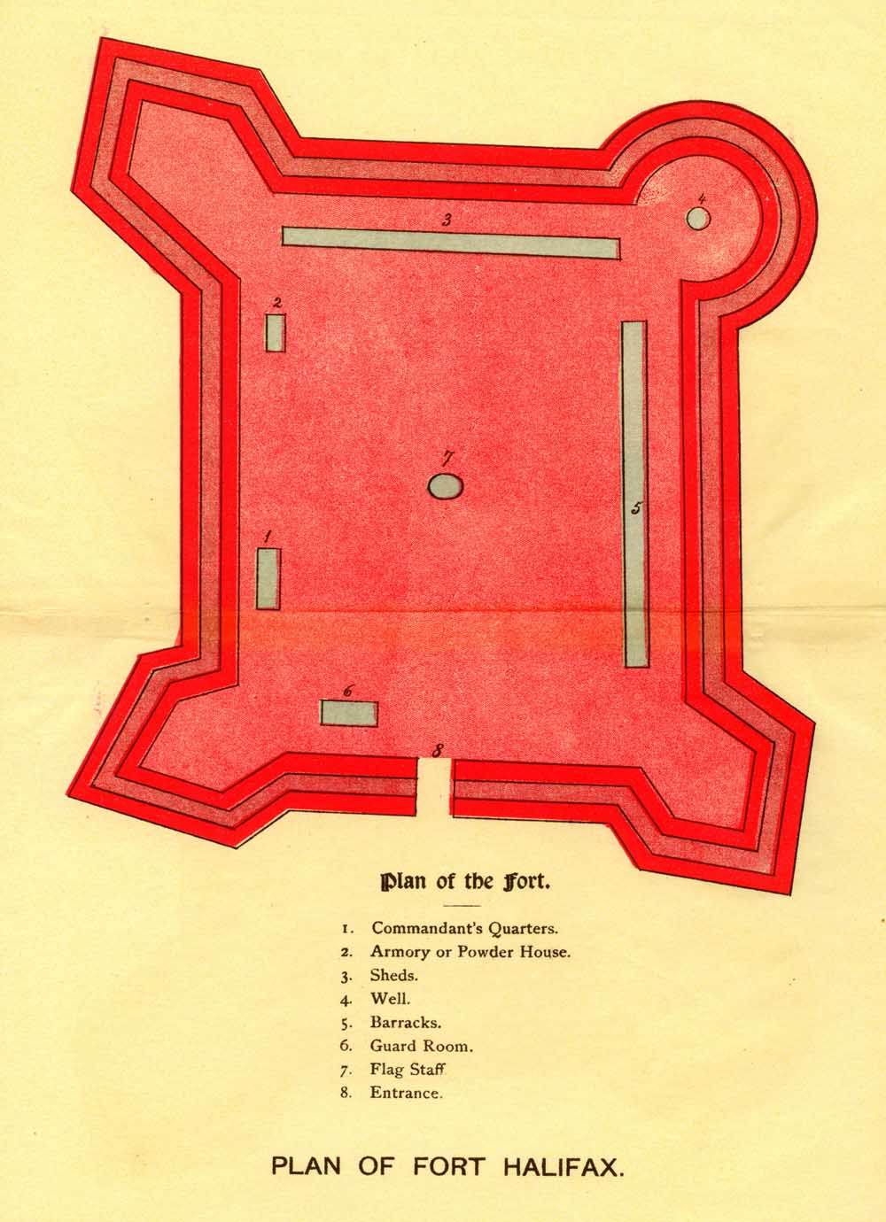
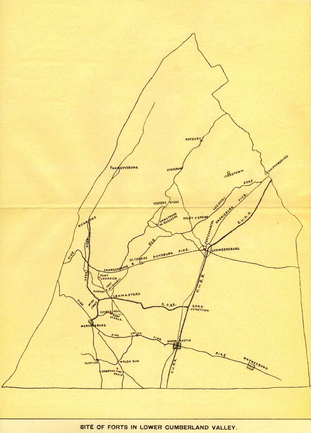
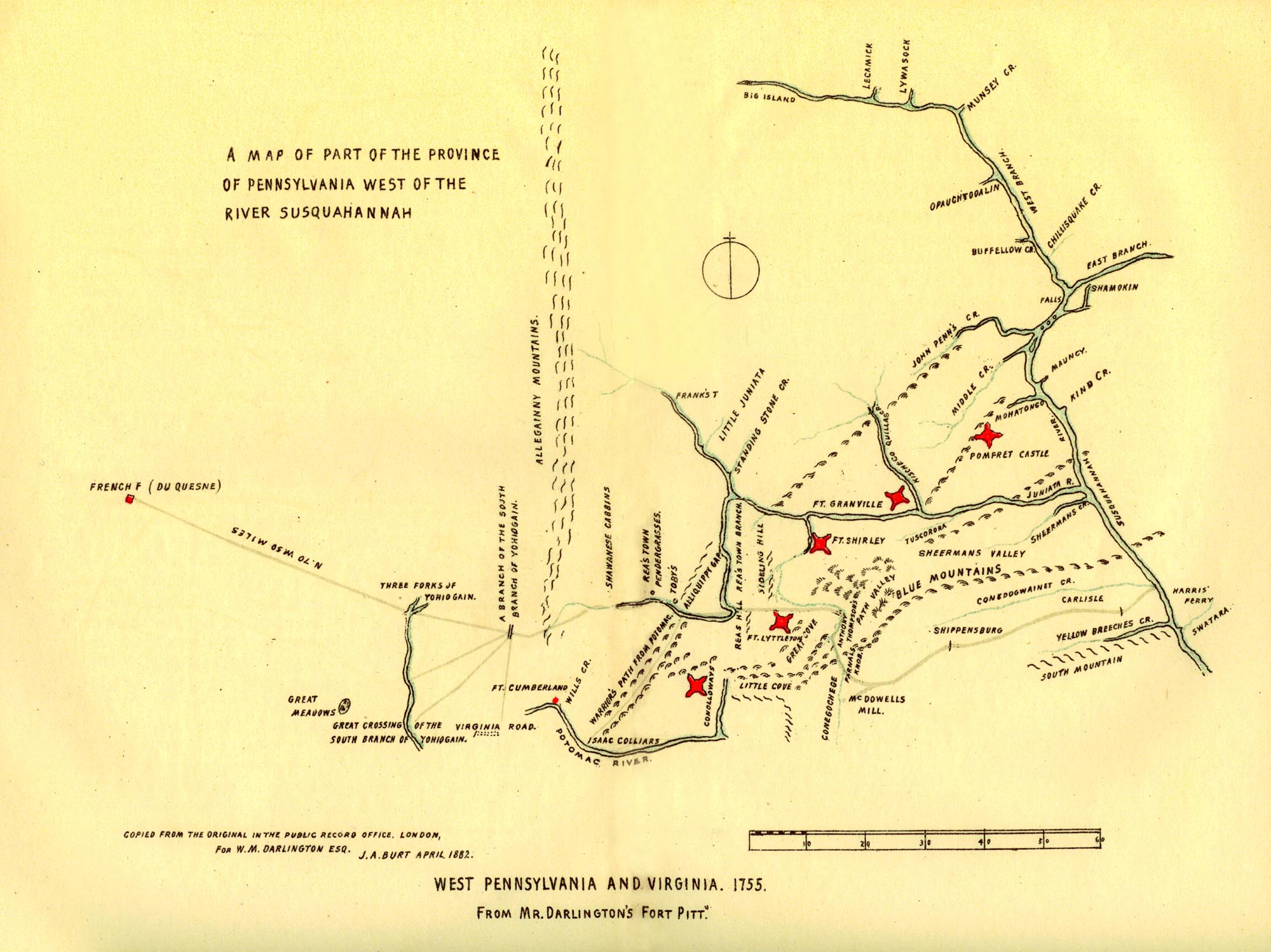